Return to California letterboxes menu
Montaņa de Oro State Park Series
| Placed: |
November 2001 |
|---|
| Created by: |
Ryan Carpenter ([email protected]) |
|---|
| Number in Series: |
9 |
|---|
| Clue Difficulty: |
Easy |
|---|
| Terrain Difficulty: |
Moderate (Best done over several days) |
|---|
| Status: |
alive and well |
|---|
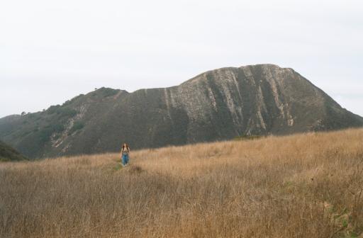 This has got to arguably be one of the most beautiful state parks in the state, and this series is meant to show you around a large portion of it. The Bluffs Trail takes you past breathtaking rock formations formed by the waves crashing against the cliffs. Peaks like Valencia Peak, Oats Peak, or Alan Peak allow incredible views of the area. The park contains a eucolyptus forest, strangely growing in a very semetrical pattern. These eucolyptus trees were originally planted to farm later for wood, but the trees--native to New Zealand--didn't grow straight like they did in their original location, and the idea was abandoned. Snakes (including rattlers) aren't too difficult to find if you're persistent enough.
The hikes in the park range from very easy to very strenuous, but I've hidden the boxes on two loops in the park I consider moderate in difficulty. They are each about eight miles in length with about 1,500 feet in elevation gain. However, if that's too much in a day, you can usually find a shorter route to any single box. Check yourself for ticks at the end of the hike. There's a lot of them out there--especially at certain times of the year. Pants might be a good idea as well, since some boxes will require a little "cross-country" hiking to reach, and not all trails are well-maintained. It'll keep the poison oak off your legs as well. =)
The picture on the right was taken near Oats Peak, honestly one of the duller areas of the park, but it's the only place I have a digital picture of to show off the park!
The nine stamps of this series make up a mural of sorts. If your stamp book is large enough, make a seascape out of it. Draw a line at the top of the page to represent the swells of the ocean. Draw little bubbles coming from the mouths of a fish or seahorse. The hermit crab is best stamped using black ink, then go back later with colored pens to color him in like a coloring book. If you get all nine letterboxes, the whole mural affect is quite impressive!
Directions: From San Luis Obispo, drive west on Los Osos Valley Road. In Los Osos, it'll curve south and turn into Pecho Valley Road. Stop at the Visitor's Center at Spooner's Cove for a free map of the park. (It's the only visitor center in the park, so if you find one, you're in the right place.) If the visitor center is closed, they'll stick the maps in the door for you to grab.
Clues:
Loop 1: Oats Peak/Coon Creek/Bluffs Trail
Placed: November 21, 2001
Status: Alive and well as of August 12, 2002
This loop first takes you up to incredible views from Oats Peak. The Oats Peak Trail is moderately steep starting at sea level and peaking at 1,373 feet along an otherwise dull trail. There is very little shade along this part of the trail, so sunscreen or a hat probably isn't a bad idea! From the peak, the trail barrels down into Coon Creek. The further down the mountain you progress, the more manzanita bushes, oak trees will start jumping out at you. Then the trail follows Coon Creek, a pretty year-round creek with all sorts of interesting stuff to look at. Wildflowers can be pretty spectacular in the spring. Watch out for poison oak along this portion of the trail, because it's very common. You follow the creek (and the trail) to where it empties into the Pacific Ocean, then follow the Bluffs Trail back to where you started from. There are no letterboxes hidden along the Bluffs trail (too many people and not any good places to hide them), so if your feet are tired at the end of the Coon Creek Trail, you can follow Pecho Valley Road back to the visitor center and skip the bluffs, but the Bluffs Trail is the most scenic (and popular) trail in the park, so it's definitely worth the effort of doing!
School of Fish: From the visitor center, follow the Oats Peak Trail (possibly labeled Reservoir Flats Trail at the beginning, since the two overlap). When the visitor center is at 275 degrees (magnetic), look for a tall pine tree on the right side of the trail. It's a good 20 feet tall, and the only pine tree of any substance you'll pass on the trail. From the pine tree, take another 22 paces up the mountain. Stop and smell the black sage bush on your right. (Smelly things, aren't they?) Just above it, in a crevace, and covered by small rocks, the first box sits waiting for you. If you've reached the trail junction with Valencia Peak, you've gone too far. Be sure to stamp this stamp several times to make a whole school of fish for your mural. =) I used a gray stamp, but any color will probably do. Draw air bubbles coming from their mouths. Very cute.
The Dolphin: Continue on to Oats Peak. You'll see the daunting Valencia Peak on your right, but don't worry about that mountain. You're going for a taller one instead. =) At last, you finally reach the top of a peak, only to realize you're still not at Oats Peak. That's the NEXT peak down the line. The two peaks make a "saddle" between them the trail drops into and back out of. The dolphin is hidden in this saddle at the base of a lonely, almost dead-looking oak tree to the left of the trail. The person wearing the pants ought to get this one due to ticks, thorn bushes, and who knows what else hides by this box. Pulling out a long-sleeved shirt and gloves might not be a bad idea either! Use a grey ink pad if you have one, and make the dolphin look as if it's jumping out of the water like dolphins always like to do. =)
Bubbles: I lied about Oats Peak being the "next" peak down the line. When you get to the top, you'll realize you've STILL got the wrong peak, but I didn't want to disappoint you just yet. =) However, the NEXT peak down the line really is Oats Peak. That trail you see following the ridge for the next several miles goes out to Alan Peak, where I didn't hide any boxes. You'll know you have the right peak because there's a marker at the top of Oats Peak labeling it as such. Anyhow, continue along Oats Peak Trail, being sure to take the right fork at the junction with Alan Peak Trail. You'll quickly start decending into Coon Creek. About half way there, when Valencia Peak is at 300 degrees, you'll come to the first wooden enclosement on your left. At the point where you can go off the trail and into the "oak forest", there will be a large, arched oak tree at 60 degrees about 27 paces from the trail. Bubbles (a fish) is hidden in the base of the tree, covered with leaves and other debris.
Starfish: Continue down to the trail to the junction with Coon Creek Trail. Go left if you don't want to leave any corner of the park unexplored--the grove of trees at the end is quite pretty. It dead ends, though, and no letterboxes are in that direction. Head right instead if you want to miss this beautiful little area, though. Cross over two bridges (or creek crossings if the bridges wash out!). After the second bridge, watch for a small, overgrown trail leading to a large oak tree and a meadow on your right. The person with the pants (and a long-sleeve shirt, if you've got it) can whack 34 paces through this overgrown trail to reach the tree at the meadow. The box is hidden in a hole in the branch laying on the ground, covered with bark. Please note: The bushes you are wacking through have TONS of poison oak in them. Unless you're feeling especially brave, don't get it without long pants and a long sleeve shirt, and change out of them immediately after getting the box!
Seahorse: Continue along the trail over two more bridges, then watch for another clearing with a large, knarled oak tree on your right. It's probably the most famous tree in this park--at least for those who've ventured out on the Coon Creek Trail. It seems like everyone stops here, so be discreet if others are around, or wait for them to leave. From the base of the large oak tree, take 14 paces at 110 degrees to another oak tree. The box is hidden in a hollow at the base of the tree and is covered with a large rock and a small log.
That's it! You've gotten all of the boxes on this loop. Ready for loop #2?
Loop 2: Hazard Peak/East Boundry/Islay Creek Road
Placed: November 23, 2002
Status: Alive and well as of April 2004
This loop starts shortly before the visitor center near sea level, climbs at a fairly good rate to the top of Hazard Peak (1,076 feet above sea level) along Ridge Trail. From there, it's mostly back downhill continuing along the Ridge Trail to East Boundry Trail, then follows the more-or-less flat Islay Creek Road back to where you parked. It's probably about seven miles total, with options along the way to extend it longer if wanted. Unfortunately, there's not a whole lot you can do to shorten the hike, but you can still pick up some of the letterboxes if you choose not to do the whole loop.
Hermit Crab: From the parking area, hike up Ridge Trail. At the first bench you reach, the trail forks. This fork is not shown on the map I picked up from the visitor center. On the left side of this unmarked trail is an old, barbed-wire fence. The letterbox is hidden at the base of the third post from the trail.
Orca: Continue along Ridge Trail. Admire the view from Hazard Peak. But don't dally too long, there's more letterboxes to be found! Continue along Ridge Trail until you reach East Boundry Trail. From where East Boundry Trail and Barranca Trail intersect, head up into the grove of oak trees at 45 degrees (magnetic). The letterbox is hidden in the base of one of the larger oaks, covered with leaves and other debris, near the center of the grove.
Trifish: If you're wondering what a "tri-fish" is, it's a star fish I stamped three times with three different colors--because I liked lots of colors in my mural. =) Continue along the East Boundry Trail until you reach a bridge. Take 24 paces beyond the bridge, and the letterbox will be in a tree/log on your right.
Aqua Fish: But then, what fish isn't an aqua one? Keep heading down the East Boundry Trail. At the intersection with Islay Creek Road, head west until you reach an old barn. The letterbox is tucked under a wall at the back, right corner of the barn. It's easier to access from the outside, though, so don't try pulling it out from the inside. You'll likely break the box it's in.
Congrats! You're done! Now you just have to finish walking back to your car. Islay Creek Road ends at Pecho Valley Road, and you have to walk up the road a couple hundred feet to get back to where you parked. If you haven't had enough of Montana de Oro, not to worry! I plan to extend this series more in the future! =)
NOTE: Always take adequate precautions (such as prodding with a stick and/or wearing gloves) before reaching into dark crevasses and holes in the wild. Before you set out read the waiver of responsibility and disclaimer.
Return to California letterboxes menu