 |
| Favorite Flying Locations |
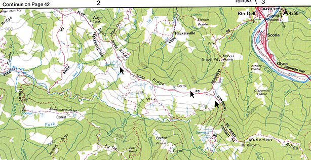
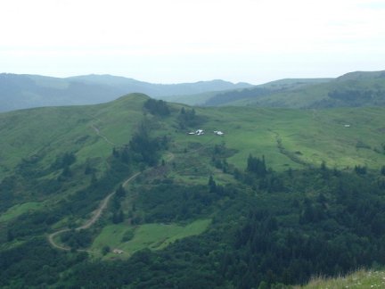
| Directions: From Rio Dell: Drive on US 101 about 21 miles south of Eureka, and turn off at Rio Dell. Go south on the main street, and turn right at 0.5 miles on Davis Road (just past Humboldt Gables Motel). Drive one block, then turn left on Pacific. Follow Pacific as it becomes Monument Road. After a winding 4.5 miles, veer right just after road becomes gravel onto Bear River Ridge Road and continue to the ridge top. Select a site along the road based on the type of flying you are after and the wind direction. The eastern most part of the ridge (the first part you will see from the Rio Dell access) is the best exposure for a northwest wind. Nearly the entire rest of the ridge gives varying degrees of southern exposure. If the wind is from the NW, use the access described above. If from the southeast, southwest, or west, you can drive the three miles or so along the dirt road on the ridge to the better south to southwest facing slopes, or come up from Ferndale to the other end of the ridge as follows: From Ferndale: Turn off Hwy. 101 at the Ferndale/Fernbridge exit and follow the signs toward Ferndale. Turn right to cross the Fernbridge bridge, and drive the 3.9 miles to Ferndale. At the other (south) end of town, take a right on Ocean at the Victoria Inn. Drive about one block, and turn left up the hill at the CapeTown/Petrolia sign. Drive 6 winding miles to the top of the hill, and turn left on Upper Bear River Ridge Road. Drive 3.9 miles, staying left at the fork in the paved road, to a nice SW facing slope just past the power lines. This spot is about 0.7 miles past where the road changes from paved to gravel, but there are several flyable slopes--select the best based on wind direction. Description: This high miles-long grass-covered ridge is often clear when Eureka/Arcata is fogged in. In the summer, winds are usually from the northwest, with the occasional spat of southwest wind as a prelude to a passing front. But in the winter, the southwest wind can blow your car off the ridge road and blow for a week at a time, usually before and during a passing storm system. You can fly the ridge with wind from either direction. Slopes facing south have nice upslope lift with generous thermals in the morning for light hand launch gliders or other floaters if any sun is shining at all. Excellent, intense, wide open slope soaring with an enormous lift band can be had if the wind is blowing. Numerous south through southwest facing slopes make this place the slope of choice when no northwest wind is blowing to make Table Bluff flyable. Besides awesome flying, the view is spectacular. Caution: This ridge forms the boundary between two large private land holdings (one a lumber company and the other a cattle ranch.) Wave and say hello to everyone you see. The property owner may stop and talk with you for a few minutes. He enjoys talking about his flying days. Pick a landing spot for your prized glider well in advance--many of those tufts of grass hold a rock. Check your receiver batteries before you chuck your plane--the valley floor is miles and miles away. Make sure those folks stopping on the ridge a bit further up the road don't pull out a glider on your channel. Drive carefully! Watch out for cows on the ridge roads, they are able to cross the road freely. Logging trucks roll down Monument road during weekday working hours, and portions of the paved access roads routinely wash out in the winter and are in various states of repair. Estimated time to fly from Eureka: 1 hour More pictures of Bear River Ridge. |
 |
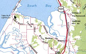
| Place: Table Bluff Type: Slope Flying Location: South Jetty of entrance to Humbolt Bay, opposite side of jetty from Table Bluff Light House Directions: About 7 miles south of Eureka on Hwy 101, turn off at the Hookton Road (Loleta/Humboldt Bay) exit. At the stop sign, continue straight across Ranch Road to Hookton road (between the barns and across the one lane bridge.) Follow this same road, and continue straight as it becomes Table Bluff Road. (No turns are necessary, but the road will wind back and forth!) Park at the bluff overlooking the south jetty beach. Description: The road goes along the edge of this high bluff, then drops to the beach below. As the edge of the bluff is rounded, you can pick an area of lift to match your tastes and wind direction. Land in the deep grass of the field behind the bluff (behind the fence), or if necessary on the beach below. Almost always a soarable site at some time of the day, light in the morning and heavy in the afternoon, and you can fly for hours at a time. Kind of fun wow'ing the tourists with acrobatics. The national open class slope duration record was established here in May 1992 by our own Jess Walls -- 12 hours 33 minutes! -- and it still stands as of today. In April 2001, the RSA held another slope duration contest and five records were set that day! Click here to see more about the 2001 contest! Caution: An amazing rotor can really toss your plane in the landing area -- some people will only land on the beach below. Piles of sticks in the landing area seem small, but loom large in the turbulence. Seems like cars always zoom along the road just as you are trying to land. The four foot fence between road and the field makes a low approach interesting. The brush and steepness make landing on the actual slope rough. The access gate to the beach is now usually open during daylight hours. A restroom is located at the bottom of the bluff, near the parking lot on the beach. It *used to be* that access to the beach was restricted with an impressive gate erected just beyond the slope soaring site. Fortunately, they have improved the site somewhat, and it is now more accessible. Access keys to the gate were available at the County Parks Office at 1106 2nd Ave, Eureka, CA. Their number is: 445-7651 if you have any questions. There was/is a $25. refundable deposit for the key if you wish to access the beach area by car. You will need to carry your permit in the car with you, and follow the regulations regarding access after sunset. You can still reach the beach to collect your plane, but expect a brisk 30 minute walk down the road, or a steep walk down a cliff trail. It's best to land your foamy in the bushes at the crest, catch your plane, or land your beauty in the rotorized field behind the slope. Practice makes perfect! Estimated time to fly from Eureka: 30 minutes. More pictures of Table Bluff. | 2001 Duration Contest. | 1999 Night Fly |
 |
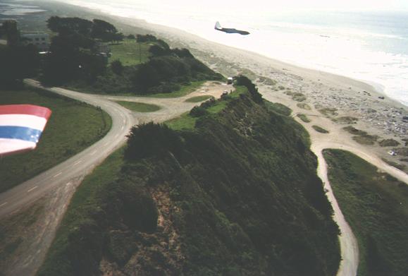 |
| Dean Thomas took this aerial photo from his "Panther" of the bluff facing SW with Mike Ackerman's Kawafoamie in the foreground. |
| Place/Location: Bear River Ridge, near Rio Dell and Ferndale, CA. Type: Slope soaring, adiabatic slope soaring, thermaling. |
| Elk River Flying Field, Eureka CA |
| Table Bluff, Loleta, CA |

|
 |
| Bear River Ridge, Rio Dell, CA |
| Temporarily closed to all flying. Please contact Dave for new information. |