|
|
Beris Dam |
|
|
|
|
| |
Here is a brief description of the Beris Dam: - |
|
|
LOCATION
.
The Beris Dam is located on Sg.Beris about 2.6 km upstream
of the confluence of Sg.Muda and Sg.Beris. The site is about
65 km south-east of Alor Setar, the capital city of Kedah
Darul Aman in Malaysia. The purpose of the dam is for water
irrigation and water suply. |
|
|
|
|
|
STRUCTURES
.
The Beris Dam consists of the following structures: -
1). A 5-metre diameter horseshoe -shaped Diversion Tunnel about
200 m in length.
2).A 40-metre high and 155-metre long Concrete-Faced Rockfill
Main Dam.
3). A 27-metre high and 195-metre long Central Earth-Core
Rockfill Saddle Dam.
4). A Spillway consisting of a 30-metre wide ungated Overflow
Weir and 89-metre long Channel with a Flip Bucket and Plunge
Pool at the downstream end.
5). An Outlet Works consisting of a 33-metre high Intake Tower,
1500mm-diameter Twin Mild Steel Conduit Pipes 184-metres long
and 1200mm-diameter Fixed Cone Valves.
6). A 7.5-meter wide, 11-Kilometre long asphaltic-concrete
pavement Diversion Road with two R.C.Bridges - Sg.Terenas Bridge
(390-metre long) and Sg.Beris Bridge (225-metre long). |
|
|
|
|
|
|
|
|
|
|
|
|
|
|
|
|
|
|
ORGANISATIONS
.
The Beris Dam is developed and owned by the
Drainage and Irrigation Department of Malaysia
under its Director-General, Dato' Ir.Hj.Keizrul
bin Abdullah.
The design and supervision of the dam were
carried out by a consortium of three (3)
Engineering Consultants: -
Wan Mohamed and Khoo Sdn Bhd of Malaysia,
CTI Engineering Co.Ltd. of Japan and
Associated Consulting Engineers Pvt Ltd of
Pakistan led by the Chief Resident Engineer,
Ir. Roslan bin Karimudin.
The Contractor for the project was a
Joint-Venture undertaking between Shimizu of
Japan and Muhibbah Engineering Bhd of Malaysia,
led by the Project Manager, Mr.Masayuki
Iwashita. |
|
|
|
|
|
|
|
|
|
|
|
|
|
|
|
|
|
|
 |
|
 |
|
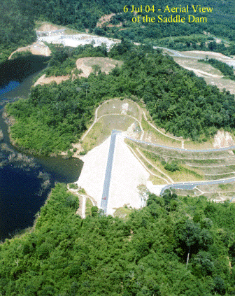
The photo shows an aerial view
of the Saddle Dam. When the photo was taken, the
dam was at its final stage of impoundment.
The Sadle Dam is a Central
Earth Core Rockfill Dam and 27-metre high and
195-metre long.
|
|
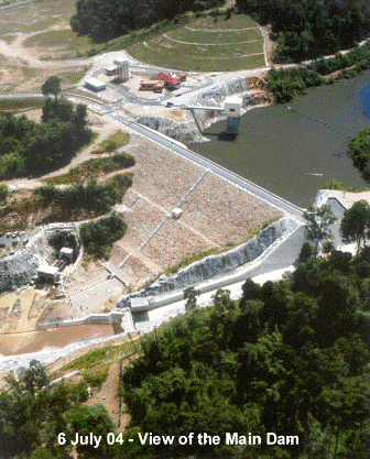
The photo shows an aerial view
of the Main Dam. When the photo was taken, the
dam was at its final stage of impoundment.
The Main Dam is a Concrete-Faced Rock
fill Dam and 40-metre high and 155-metre long. | |
| |
|
|
|
|
|
|
|
|
|
|
|
|
|
|
 |
|
 |
|
|
|
At a height of 40 m, the reinforced concrete Sg. Beris
Bridge is considered to be the highest bridge in Kedah. |
|
At 390m in length, the reinforced concrete Sg.Terenas
Bridge is considered to be the longest bridge in Kedah |
|
|
| . |
|
|
|
|
|
 |
|
OTHER PROJECT DETAILS
.
Original Cost of Project = RM 184.4 Million
.
Duration of Project = Four Years (10/8/00 to 8/7/04 )
.
Date of Impounding = 2nd Feb 04
.
Reservoir Area = 16 Km2
.
Catchment Area = 116 Km2
|
|
|
|
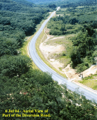
The above 11-km Diversion Road was
constructed to replace the existing Sik-Nami Road, which
was submerged by the Dam's reservoir at the end of the
project. |
. |
|
|
|
|
|
|
|
|
|
|
|
|
|
|
|
|
|
|
|
|
|
|
For further enquiries or information, please
write to [email protected] |
|
|
or fill and send the mail
form |
|
|
|
|
|
Address: 8C, Jalan Mesra 1, Taman
Mesra, Shah Alam, Selangor Darul Ehsan,
MALAYSIA. |
|
|
|
|
|
|
|
|
|
|
|
Tel: +603-5519
1855 |
|
Fax : +603-5519
2866 |
|
Mobile: +6013-2020
998 |
| |
|
|
|
| |
|