 |
|
|
|
|
|
|
|
|
|
|
|
|
|
|
|
|
|
|
|
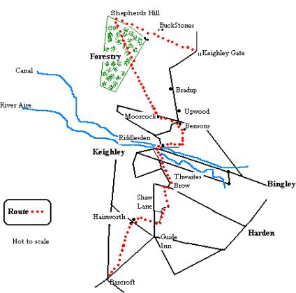
| Walk/Run the Bingley Boundary 2: Keighley Gate to Barcroft |
|
|
|
Distance 10 miles approx. |
|
|
|
 |
|
|
From the radio masts, follow the wall north-west as it heads up towards East and West Buck Stones. Ahead you can see the Tilhill Economic Forestry plantation. The actual boundary heads off left at the wall and now we have the right to roam we can legally turn left but a better if longer route is to follow a faint path which heads off right from the Buck Stones down into the perpetual bog of Crawshaw Moss. The path skirts round to the right in an attempt to follow the least boggy line. Follow it but when it heads off away to Addingham Moorside stick by the wall. Keep by the wall, pass the boundary stone and carry on until you hit the ladder stile. On the O.S. map this is marked as Shepherd's Hill where, according to historian, Cowling, worked flints and pieces of chert from the Mesolithic period were discovered in 1930. Since these date from almost ten thousand years ago we are following very old footsteps. Follow the footpath through the forest that is of more recent 1970's vintage. It's not a natural landscape but it's atmospheric. At times the trees close in on the path to the extent that you feel you will meet a troll round the corne though recent felling has left a landscape more like a WW1 battlefield. High winds often bringt down trees so you may have to make a few detours.The path eventually comes out at a stile leading onto the moor. A faint but marked path leads on to Bradup. We want the other right of way heading towards Moorcock Farm on the Silsden Road (a moorcock is a grouse) but it doesn't exist on the ground as marked on the map. The best bet is to follow the wall right till it meets the fence with a stile. Ignore the stile and follow the path by the side of the wall/ fence until it meets the right of way leading�� up from Upwood. Go left for a little way� until you see two stone posts in a broken wall. A faint track right then connects to the footpath to Moorcock Farm. Follow this path over stiles to the road. The most direct line now would be to follow a supposed path a field length's away to the right shown on the OS map as leading down the wall side� to Heights Farm. |
|
|
|
|
|
|
The area round Riddlesden is sometimes referred to as Morton Banks and it was at Elam Grange near here that Simon Mitchell,a local farmer discovered a copper chest containing Roman coins. The coins seem to have been shared amongst the locals though the Busfeild family still had a collection of them at the turn of the nineteenth century.The Marquis of Granby takes its name from the 18th century military commander who bought inns for his officers wounded in the Seven Years War. |
|
|
|
|
|
My own attempts to follow this path found no signs, or stiles but plenty of barbed wire, and resulted in much involuntary transgression of the country code. So� head left at Moorcock farm crossroads by Bensons Caravan Park. Turn right down Ilkley Road and immediately left down the track behind the houses. Take the path behind the houses that descends into the field. Bear left to the marked stile and follow the path down to the farm. |
|
|
|
Click on the runner to return |
|
|
|
|
|
 |
|
|
|
|
Go down the side of the farm and turn right and then left down the track. Keep going downhill to meet the path that skirts the grounds of the old isolation hospital. Turn right and follow the path until it comes out on Hospital Road. Follow the road to the swing bridge by the Marquis of Granby pub. Cross over the bridge and the main road by East Riddlesden Hall. |
|
|
|
|
|
|
The next section is rather brutal. Take the main road towards Keighley but turn left down Aireworth Road. Follow this to the Aire Valley Road roundabout and cross over on the left. Take the Wenning Street exit and bear left before heading up the steep cobbles of Thwaites Brow. Follow this to join the Keighley/Harden road. Go down the Harden Road at Long Lee a little way and take a track left leading to a gate. Take the path heading up the rocky hillside by the side of the old quarries. Follow the path onwards over stiles and fields as it takes the line of the wall. Before it steepens again to meet the bridleway, head off to the right on a good wide grassy track. Follow this till you meet the track heading up to Harden Moor. Cross over and carry on down Back Shaw Lane. It is thought that the Roman road from Ilkley came this way and proceded along side the road towards Cullingworth. Back Shaw takes you to Shaw Lane. Cross over to the other side and go through the stile by the house and take the path that heads down across the fields. After moving diagonally, head along the track which leads left to the farmyard and the road. Turn right and then left into the hamlet of Hainworth. Follow the bridleway, signed as the Worth Way under Hainworth Crag as it leads to Barcroft. The track is good but churned up by horses. This track leads to the Bingley Road that in turn leads to Barcroft and the Keighley/Halifax Road. |
|