Nab Wood to Keighley Gate

| Run/Walk the Bingley Boundary: Section1 Nab Wood to Keighley Gate |
||||||||||||||||||||||
| Distance: ten miles | ||||||||||||||||||||||
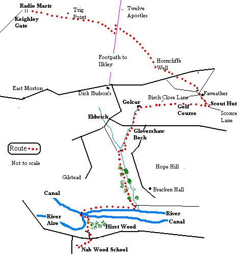
| From Nab Wood school, cross Bradford Road and head down Branksome Drive . Keep right when you hit Branksome Grove and when the road veers left take the� footpath on the right by the side of the house that leads down to the River Aire and Hirst Wood. Head down into the wood and bear left, keeping the river in sight. This path leads to the canal towpath. Head left and then go round the back of the house with the sewage works on your left, until you come out near the Dowley Gap canal bridge. Go over the bridge and right through the gate. Now take the steps dropping off left that lead to the riverside path. Looking right you have a good view of the Seven Arches. Follow the path that takes you to the rowing club. Take the rowing club track till it joins the approach road to Milner Field. Turn left and then right at the old lodge. Head uphill through the gate and continue the climb on the path directly opposite that leads you up into the wood. Follow the path that moves along the top of the wood. Where the wood thins out head down right to cross Loadpit Beck and go right to a gate. Go left on the path up the hill with the beck on your left. At the junction of paths just above the old quarry go left on the signed Milennium Way. Take the path that leads by the side of Glovershaw Beck up to the farm. Cross the Bingley/Baildon road at Glovershaw and take the road to Golcar Farm. Ignore the stile for the Dales Way link and bear right and across the fields towards the golf course. Go over a stile and take the right hand path but almost immediately leave it to skirt the left hand side of the golf green. Aim for the wall and follow the path along the side of the fairway. At first it's churned up by horses and then turns into a green track. Head towards the holiday cottages by the wall in the distance. Follow the path by the wall until it meets another path by the scout hut. Turn left through the two stiles at the hut to reach Sconce Lane | ||||||||||||||||||||||
|
||||||||||||||||||||||
| Sconce means a shelter or small earthwork. There was in fact a small hamlet called Sconce near to the scout hut but the cottages, which housed the local coal miners, were demolished in the 1950's along with other colliers' cottages at Low Hill next to the Primitive Methodist Chapel, now a private house.�� | ||||||||||||||||||||||
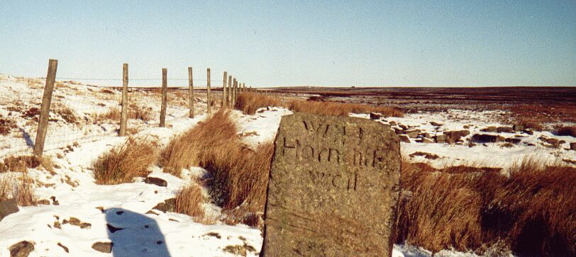
| Take the track to Faweather Grange. Bear right when the track meets Birch Close Lane and then take the second track on the right which heads in front of the renovated Little London farm and then down to cross the stream. Follow the rough and boggy path uphill along the side of the wall. Go through a gate and head up the side of the wall to a stile. Now cross� the busy Bingley/Otley road between Weecher Reservoir and Knapley-Ing Farm. Opposite is a stile, which leads to a footpath heading over the moor. Local historian La Page calls this track Thorn Gate. This path regains the old parish line and leads up to Horncliffe Well. | ||||||||||||||||||||||
| Horncliffe is a very evocative and haunted spot. Some remnants of the old keeper'scottage are visible on the other side of the wall. A short way to the northeast lies one of the moor's ancient stone circles, though it's now marked on the OS map as Enclosure. You can cross the wall at Horncliffe and take an interesting route (now part of the Bradford Millennium Way) to Ilkley past the reservoirs and the long lateral moraine of Lanshaw Delves. This glacial material contained limestone from the Dales and the area was once littered with lime pits. | ||||||||||||||||||||||
|
||||||||||||||||||||||
| The route stays to the left of the wall for another few hundred yards where a stile leads to boggy ground. The public right of way moves slightly away from the wall. Soon you join the popular Dick Hudson's path where a large stone tells you the distance to Ilkley and Bingley though it faces in an unusual direction. If you follow the Ilkley path you soon come to the twelve apostles stone circle and you can turn along the edge and return to the route by way of the trig point.� If not tempted, turn left and move southwards back towards Bingley until you meet the wall again. Don't cross over the stile. Instead, leave the main path and head uphill along the side of the wall. This isn't marked as a right of way but on the Ilkley side of the wall you are on common land Follow the wall. You are headed for the police radio masts in the distance. On the way you pass the rocks of Ashlar Chair where you meet another cross moor route to Ilkley. Finally you reach the masts and the road that I've always called Keighley Gate, though it's marked on the map as Whetstone Gate. | ||||||||||||||||||||||
| The word gate has two meanings. It can be an entrance or a path or way. When it occurs as a place name element it derives from Old Norse� gata and indicates an old road. At one time Bingley had two gates, High Runagate and Low Runagate, which went from Eldwick across Gilstead Moor. The path we took from Horncliffe towards Ilkley was once Ilkley Gate while that heading due north was Castle Gate. The old Roman road south of Olicana heading for Mancunium came near Keighley Gate, heading towards Morton and across the Aire valley. There were more track ways meeting here. The 1852 O.S. map shows a track heading up from Sunnydale and crossing another track that come from the top of Morton Stoop. Local writer, Greenbank, tells us he found a stone pillar dated 1739 "exactly central of Black Knowl and Upwood" with a chiselled hand and indications of mileage to Skipton, Otley and Keighley. The current OS maps still show the supposed remains of a cross close to the meeting of the old tracks though the first OS map did not. These tracks across Morton Moor� have now� disappeared. According to Greenbank the public were excluded after the Moor Enclosure Act in 1816 though Dodd, the Bingley historian, dates the enclosure of Morton Moor as earlier in 1790. | ||||||||||||||||||||||
|
||||||||||||||||||||||
| Keighley Gate to Barcroft | ||||||||||||||||||||||