 |
|
|
|
|
|
|
|
|
|
|
|
|
|
|
|
|
|
|
|
|
|
|
|
|
| Bingley Run/Walk4 Hope Hill |
|
|
Distance: 7 miles |
|
|
|
 |
|
|
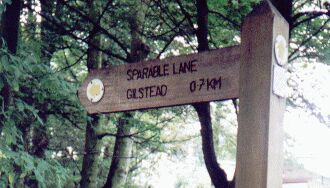
| Join the canal at Bingley and head east along the towpath, past the Fisherman's pub to the locks at Dowley Gap. Cross over the bridge and go left up a� snicket, coming out on Primrose Lane. Turn right and head uphill on the road with the old Milner Field estate on your right. Just before the junction at Gilstead turn right down Sparable Lane. Follow this until it meets Sheriff Lane. |
|
|
|
Sparable Lane is part of the old route from Baildon to Bingley.The word sparable is something of a mystery. It's a shortened form of sparrow bill, a name for a type of nail used in old footwear like clogs or pattens. |
|
|
|
 |
|
|
|
 |
|
|
|
|
| Head right and follow the track past the exotic gate and down to cross Loadpit Beck near the� reservoir. Now leave the path and head up and slightly right towards the crags. The long stretch of rough rock gritstone� crag here is a boulderer's paradise.�Go across the flat green whose mounds and stones known as the Soldiers Trench are evidence of Iron Age settlement. Cross Prod Lane and take the signed footpath to the right of Bracken Hall. This leads round and over a wall stile to the fields. Head upwards across further marked stiles towards Hope Hill. Soon you leave the fields and head up through the bracken between Dobrudden and Crook farms with their caravan sites. |
|
|
|
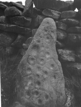
Cup and Ring, Dobrudden |
|
|
|
|
| The Old English word hop can refer to a valley, which seems inappropriate for Hope Hill but the word has the initial meaning of an enclosed area in a barren, marshy or moorland area. So the hill is probably taking its name from the settlement around Hope Farm.Dobrudden, La Page, the Baildon historian tells us, was previously known as Dobridding and as Dobb's clearing. The English Place Name Society gives no derivation but Dob Field in Oakworth is derived from the Middle English personal name Dob. This prehistoric cup and ring stone is cemented into the north- west facing wall of the caravan site at Dobrudden. The Ilkley Archaeological group in the most recent and definitive survey (1986) list twenty eight carved rocks in the Low Plain/Windy Hill area. |
|
|
|
On Hope Hill the coal measures lie over the Millstone Grit and there were once pits of various types. Local ironstones were probably smelted with local coal at an early date. There's bright orange streaking from the local ironstone in some of the streams. A pit near Dobrudden supplied coal to Baildon and Eldwick Mills in the early nineteenth century When the pits closed undermined by cheap coal brought in by rail, buildings were demolished and the shafts filled in. The cinder caves themselves are of a later date. La Page says they are the result of the burning of pit rubbish "to provide scale for the old type of roads and paths of the district." |
|
|
|
Follow the path onto the top of the hill and move left to the trig point. This is an excellent viewpoint. Baildon Moor itself was a common and was purchased for Bradford Corporation in 1897. It is now an extensive area of open access. Head north towards a track that leads towards the Baildon/Bingley Road. On your left note the old slag heaps locally called the cinder caves. |
|
|
|
|
|
Cross the road and take a track heading northwest between the greens of the golf course. It's often marked with the hooves of horses. |
|
|
| The 1852 OS map shows a large barrow to the right of the conjunction of tracks near the Baildon road and during the nineteenth century a number of excavations in the vicinity unearthed a variety of urns. When the golf greens were extended on Penny(i)thorn Hill in 1904 a workman unearthed a Bronze Age funeral urn containing burnt human bones. This urn is currently on display at Bracken Hall on Shipley Glen. The golf course was first developed in the late nineteenth century as Bradford Golf Club but the Bradford club moved to Hawksworth and a local club took over. |
|
|
| As you cross the last green there is gate which leads to the churned up horses' gallop. Go through the gate and bear diagonally left across to the open ground.� Pick up a faint path leading west to a stile in the wall. Cross the Dales Way link from Golcar Farm and keep heading west along a farm track with a gate warning off all but the pedestrian. This is shown as Longcroft Lane on the old maps and must once have been a bridleway connecting to Birch Croft Lane. You soon come to the Dick Hudson's road from Eldwick. Turn left and almost immediately right into the drive in front of the old houses. The footpath is signed as it weaves its way round the gardens and farm buildings to lead to a stile. Cross and follow the right of way down the side of a wall over one stile and then another which takes you into a narrow snicket. Follow this downhill to come out on a tarmac drive near a white gate. Follow the tarmac for a short way until the drive curves round to a junction with Tewit Lane. Ignore the two likely options and instead go through the field gate just past the Tewit Lane turnoff and head diagonally upwards across the boggy field. A stile takes you through the fence. Keep left and go to the left side of the wall. Head down the wall to another boggy section just before a wall stile. Stride boldly through and pick up another wall on your left moving uphill. Follow the path round� over stiles to come out on Heights Lane. Turn right and after a few metres turn left by a gate leading to a dilapidated farm building.� The path on the ground leads diagonally across the field to come out at a stone stile. Follow the wall behind the old Bingley College buildings until you see the stone steps of the wall stile. Follow the path round the smart detached housing until you come out on Lady Lane. Turn right and just before the turn off for Greenhill Lane, take the footpath marked on the left. Follow the snicket all the way down to Beck Lane. Turn right and then left to come to Five Rise Locks. Head back along the canal to Bingley. |
|
|
|
 |
|
|
|
Click for home page |
|
|
|