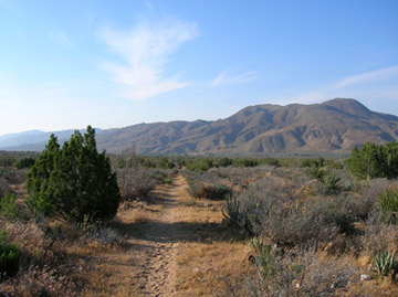
Pioneer Mail Trail
Elevation: 5280'
Trail Miles: 53 mi
After a late start this morning we packed up and headed down to the store. Since the post office did not open until noon we all sat outside going through our pack and finding extra unnecessary items.
As the morning progressed a few more thru-hikers showed up. "Neighbor J" and "Chowder" came up with their 60-70 pound packs. Apparantly "Neighbor J" is writing a book and recieved many sponsers and has plenty donated gear.
We all wandered in & out of the general store getting microwave pizzas, coffee, breakfast burritos, orange juice, and fruit. As the hours passes by we all shed more weight from our packs and drank alot of water.
We sat for a few hours in front of the store waiting for the post office to open, literally counting down the minutes. Noon hit and boom the Postal worker was flooded with six smelly backpackers aching to get there food boxes so they could get on the trail.
My box arrived packed full of yummy goodness and sardines (not so yummy). I asked my parents to put together boxes for me, and I would supplement what they sent me with what i could find in the store. For this leg they gave me enough...added to what i had left over I should be able to make it past warner springs, maybe even to my next drop in idyllwild (with a small purchase at warner springs). My mom included a wonderful butterscotch peanut brittle-esque dessert. It has been fashionably named "Essence of Love."
Once all the boxes had been torn open and unnecessary food/gear was disposed of in the "hiker box" we set off. (A "hiker box" is to drop food/gear into it so that future hikers coming through can take something they might want/need.)
So down the trail we went Jon, Debi, myself, "T-Pot", Dave, Jessica, "Neighbor J", and "Chowder". Without stopping we put on 5 trail miles to a look out point where we stopped and took off our shoes, stretched and ate. "T-Pot" and I strolled along sharing bad jokes and riddles. Completely unaware of the distance we had traveled we stumbled upon the other hikers. We sat down at the view point and had food and foot rubs.
After a short rest and a little water resupply we headed out again to cover 5 more miles. It was easy going and we could see the trail for long distances, which we covered quickly. I am still not broken down by the trail and definately not ready for the long days to come, but i could feel a difference in the way that I have hiked today and the way I hiked the first day. Typically we have moved at about 2 miles per hour, but this afternoon we sped it up over the beautiful terrain to 3mph.
As we wandered around the crest we were beat by heavy winds (once blowing Debi's sunglasses off). The land had recently been burned so all the trees were branchless and burned black. But the ground was alive with a fresh array of vegetation. Short low lying chapparal that in time will rise to four or five feet like in the first part of the trail.
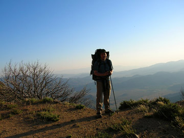
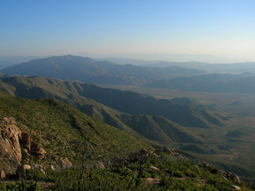
At one point we rounded a corner and had a stunning view of the next two weeks worth of hiking. The slope was incredibly steep and I recall hearing everyones voice ring out "woah", "holy", "kreiky" and other words of awe at the steepness of the slope combined with the stunning view.
After gretting into camp and cooking our dinners, Debi gave me a back rub because she had left over energy from the short day. I had a bit of left over energy so "T-Pot", "Chowder", "Neighbor J", and I played frisbee. (Yes someone actually brought a frisbee...doubles as a plate...yes he will probably send it home soon...but I was happy to enjoy it). After loosening our muscles with a game of frisbee we crawled into our tents and told jokes until we slowly became sleepy.
A coyote just sounded...closest I have ever been to a coyote by the sound of it, and now I think I will sleep.
May 3rd
Elevation: 2375 ft
Trail Miles: 79 miles (26 today)
Todays journal is brought to you bby the color yellow, the number 26, and the sound ahhgh uhhh.
We set out early this morning to make our way 26 miles through rocky desert terrain. The first five miles provided a stunning view of the next two weeks of hiking. "T-Pot" and I wandered up the hill together talking about the outdoor jobs she does. Sounds exciting, I might try that. (just a thought).
Five miles out there was a water cache ("trail angels" drop gallons of water out at hot dry locations). It was here where my foot started feeling funny. I kicked off my shoes and saw my first blister...59 miles north of the mexican border. Not a comfort, but better than some other feet i have seen. Also after 59 miles is better than my typical experiences of a blister after 6-10 miles. Goes to show you what good boots, liners, and socks will do for you.
Just past that we winded up into hills that were full of yellow. At first glance we saw an entire hillside that looked to be covered in yellow cloth, but as we neared we saw it was just millions of tiny lowlaying yellow flowers.
The next 10 miles were filled with 5 different types of yellow flowers from the small ones to buttercups, to what appeared to be giant buttercups. I also noticed the arrival of a new plant, which I believe was a juniper bush. As the miles wore on the yellow flowers started to become interupted by purple flowes. Before I knew it, I had dropped o an elevation that had a full rainbow of yellow, blue, purple, red, and white flowers. The extra rain California got this year truly has put on a stunning flower show for us thru-hikers.
After passing through the flowered hillsides of higher elevation we dropped down into a lower elevation where the midday sun cooked our skin and made plant life diminish to sun bleached branches on small chapparel bushes and three kinds of cacti, including agave and prickley pear cacti (i believe) which had the most beautiful purple bloom coming off it. Also not too fun to sit on, as Debi eperienced.
To start off the last 10 miles of the day, my shoelace broke. This put me further back than the rest of the group for quite a while. Exhausted, hot, hungry, and tired I struggled to catch up, and succeeded with 5 miles to go.
The last five miles brought us off the desert hills and down onto the sandy desert floor, where we walked for hours (or so it seemed) across flat dusty terrain. The most desert like I have experienced.
Finally after 26 miles we collapsed into camp where set up our tents, washed our socks and bodies in a small creek, and cooked dinner.
Now I sleep. Possible 21 miles tomorrow.
May 4th Evening
Elevation: 3535 ft
Trail Miles 101.9 (21 today)
Today started with a later than desired start. But after hiking 26 miles it was hard to wake up and get going. Nonetheless, we hit the trail at 7am, an hour later than we hoped, and boy did it hurt being late.
As we went uphill for 14 miles into the San Felipe Mountains the sun beet down on us laughing at our lack of shade. To add madness to mayham, we also had to carry alot of water. And to add further madness rattlesnakes were prevalent in this area. I saw one that was incredibly angry, up in the air like a cobra ready to strike the next thing that moved. Jon and I had to step off the trail to get around it, but since the trail was on a clifflike surface it was very difficult. I had one other minor encounter with a rattlesnake a few hours later.
After the long long long hot winding rise into the San Felipes, we took a long lunch at a water cache. After lunch we contined up the hill winding along its perimeter for seemingly endless miles. Finally we crested it and had a long winding path down the other side of the Felipes.
With sweeping views of the land, a sun which no longer boiled our skin, and a fed body, the second half of the day went by much better. I even walked the last 4 hours without removing my pack to rest.
After the day was finished, we found ourselves at a natural spring and an eden-like campground. I dropped my pack and hobbled over to the spring where I shed my cloths and washed my aching blistered sun burnt body in icey sping water.
Shortly afterwards I had a dinner, did my laundry in the spring and then set up camp. Dave, Jessica, and "T-Pot" stopped short of eden, so Jon, Troy, Debi, and I enjoyed a campfire before bed, glumly without them...but "You hike your own hike."
May 5th
Elevation: 3235 ft
Trail Miles: 111.8 (10 Today)
After having a nice rest we woke up at 6:30 this morning and hiked a very nice 10 miles out to Warner Springs.
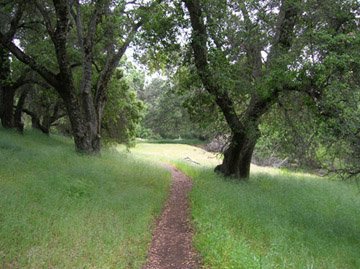
The trail wandered between lush greens and wide open fields. Being a little sore from the last two days I was glad to have a half day. Even better tomorrow is a "Zero Day."
While walking the 10 miles out, I fell behind Jon, Debi, and Troy to adjust my shoe. I had the cool misty morning to myself as I wandered from pasture to field to pasture to desert-like oasis. The last three miles followed a stream down to Warner Springs where Dave, Jessica, and "T-Pot" were waiting for us.
After having a small bite to eat we walked down the highway trying to hitch a ride. "T-Pot" and I were walking in the back so we had the first opportunity to hitch. After being unsuccessful for a bit, she was getting hot so she hoisted her thermals up to cool her legs. The next car we stuck our thumbs out for stopped to give us a lift. It was Troy's cousin, he knew he was in the area so he offered us a ride. A little further down the road we got up with the rest of the group.
We then checked into the Resort we are staying at for a little R&R and reward for the first 100 miles. We have all been eagerly waiting to go soak in the natural hot springs. But first....FOOD.
In honor of Cinco De Mayo (and our tired hungry bodies) we drove 8 miles down the road to a Mexican Restaurant where we all had good eats. After our meal we went grocery shopping and returned back to our room (resort room for six people).
After a little rest I am going to go soak in the springs to relax my body. Tomorrow we will hike the three miles of the trail around here without our packs, and then early saturday morning we will continue north. In about three days we will reach Idyllwild, but since California has been getting so much precipitation, the rangers are rerouting hikers around a dagerous pass (unless you have crampons and an ice axe).
We should be hiking in the rain a bit over the next couple days which will add another fun twist to this whole trail thing.
A Note on Trail Names:
More common on the Appalachian Trail, but some people pick them up on the PCT as well. Names have meanings generally, but you don't always get to hear the story. Here's a few.
Dave - "LOT" (Loses Our Things)
Debi - "Ladyface" (we started saying that and it stuck)
Jon - "Zing" (says that alot on punchlines to jokes)
Tiana - "T-Pot" (she cooks in a teapot, and always sang the song on the AT to remind herself of her childhood)
"Phantom" (He always would be ahead of someone and would then dissappear and come up from behind them)
Other trail names "Neighbor J", "Chowder", and "Rabbit"
For me nothing has stuck...suggestions
"I Like Food" - I say that alot
"Psycho" - Apparantly I say crazy things often
"RodgePodge" - Full of a Hodgepodgery of information.
Soon one will stick.
Now its time to go soak in the hot springs.
Happy Trails, Inner Peace, & Harmony
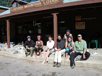
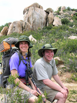
Our First Package Pickup at Mt. Laguna Lodge (Myself, "T-Pot," Debi, Jon, Dave, Jess, and ?
Sunburnt, but Happy
Who Wouldn't Want to be Here
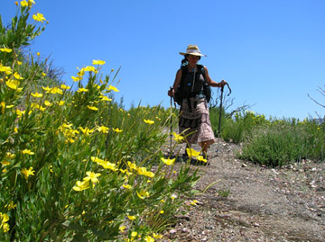
"T-Pot" Walks Among the Yellow
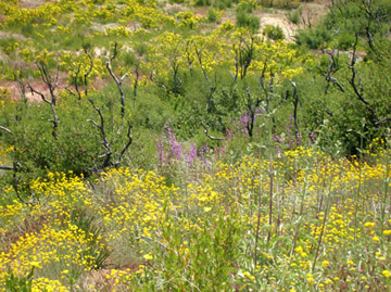
Today is Brought to You by the Colors Yellow and Purple
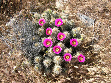
Fun to Look At, Not Fun to Sit On
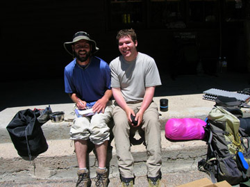
Debi and I
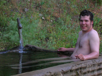
A Well Deserved Hop in the Tub
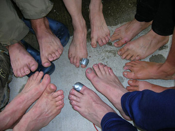
Trail Beat Feet