June 8th Evening
Elevation: 5340 ft
Trail Miles: 575 miles
Arriving in Tehachapi, several hiking buddies started feeling sick. J.C (”Whatever”), Jason (”NaborJ”), “Tombstone”, Dave (”MapDave”), and Laura were all sick. We couldn’t quite figure out what it was, but apparantly alot of people have gotten sick from a stream we passed by. Even those who filter.
With many people sick, we took some extra time in Tehachapi. This turned out to be a good thing since the town was rather spread out. Going to the post office, sorting your food, buying more food, and going back to the post office was time consuming because of the lack of proximity between resources. Fortunately for us my aunt came and visited.
My aunt shuttled Laura to the hospital and then took Debi, Jean Luc, and me to lunch. She even bought some fudge for us to enjoy on the trail. (Thank you Aunt Sharon). After that, she took us to the post office and then dropped us back at our hotel. Shaving time off my tasks, I was able to enjoy my stay a little more.
Returning back to the trail at 9:30 this morning, we brought a “water cache” for some other hikers (as it was a long dry stretch for some). We also brought half a bottle of vodka, for those wishing to have a midday treat.
Stashing that away for the hikers, Jon, Debi, and I started hiking again. We started with a walk alongside Highway 58 (not all the trail is filled with magnificent serenity). Shortly we started a climb of rounghly 2000ft. With driving wind our progress was slow, but at least the heat wasn’t killing us.
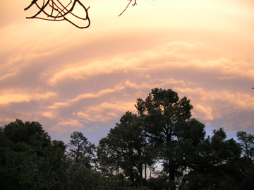
I spent alot of time looking up at one cloud overhead. It amazed me how I could be struggeling against 40mph winds and the cloud lingered up there unmoving, like a spacecraft hovering overhead observing my struggle. (Thank you Ula for changing the way I think)
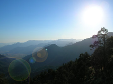
As we climbed higher the view became spectacular. We could see the distance we had traversed over the last 2-3 weeks. A distant snowcapped Mt. Baden Powell followed by a long gradual descent down to the desert floor. Of course we also experienced countless ups and downs that are not experienced from afar.
Fighting the wind we climbed higher until we started reaching white firs and pinyon pines. The trees beckoned to us with their outstretched limbs, “Come rest in my shade, get out of the wind.” Sadly, we had miles to make if we were intending on doing the whole trail this year.
As we passed through the trees we were dropped out on an old jeep road. Walking along the road for roughly five miles, the tread constantly changed; going from a chalky white to a amber brown that complimented the branches of the manzanita bushes.
After the road, the trail wound through another hypnotic wind farm. Several thousand of these wind turbines spin with the wind, generating enough electricity for one quarter of a million residential homes. Furthermore, No Polution.
After passing through the wind farm, we slowly dropped down the northern side of the hill. Since my foot was hurting, I decided to take it a little slower. After about 3 hours of hiking alone, I saw Debi. She thought that she had lost the trail, and hence was coming back up the trail. But she hadn’t, so I told her to turn back around, and the two of us marched on to the next water source.
Jon was waiting there, so we decided to cook our dinner and filter water. After all that was done, we enjoyed some yummy maple fudge, compliments of my aunt. (Thank you Sharon). After desert we hiked a little longer until we found a descent spot to hunker down. Not wanting to compete with the wind we are “cowboy camping” again.
Soon the Sierras will come into view. I am filled with fear and excitement for the adventures that part of the trail is going to throw at us.
June 9th Evening
Elevation: 6400ft
Trail Miles: 607 miles
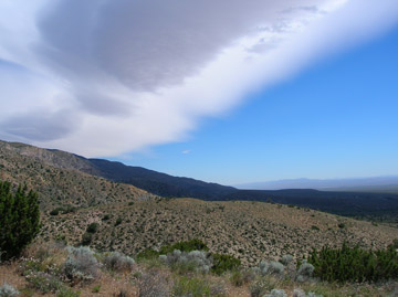
Today was a day of solitude for the most part. Rising to a lighter wind and a great deal of clouds overhead we set out at 6:30. Other than the rests it seemed like we were all hiking alone. The clouds became fog, as we were slowly enveloped in the grayness.
Wandering through the Piute Mountains, I felt like I was back home, except for the hillside freckled with Yucca plants. I walked along a trail of Miners Lettuce as we wound through five species of oak trees. The monoliths were covered in lichen from a rusty brown shade to a vibrant green. The fog was thick enough, that once you were 60feet behind someone, you could no longer see them. This kept a very calm silent hike for all of us.
It was not until the moisture had passed, and we had hiked 20 miles that we could see eachother again. After going 19 miles and having a good chili dinner (compliments of “T-Pot”, thank you) with mashed potatoes, we decided to push on. The sun started warming and drying us as we weaved through Jeffrey Pines. The tread was a nice pine duff, so we walked easily to where we found camp, set up and had a campfire with Brian and “Canadian Bacon.”
Time to sleep. ![]()
June 10th Evening
Elevation: 5070 ft
Trail Miles: 631 miles
Where did the nice forest go? Yesterday we were walking through fog and clouds, getting wet and cold. But within an hours walk this morning we descended out of the comfort of a fine forest. The pine duff trails faded into decomposed granite, and the trees shrunk to small shrubs and Joshua trees.
The day was going to be a long one. In theory, there was 35 miles between water sources, but thankfully there was a water cache along the way. As we dropped down out of the higher forests of the Piute Mountains we felt the heat rise. I struggled along today, because my foot has been acting up throughout the day.
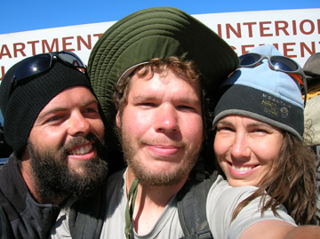
As we neared lunchtime, shade was nowhere insight. Finally, a small rock outcropping offered enough shade for most of us. Surprisingly, once I removed my pack, the heat of the sun seemed much more tolerable. Resting on the rocks, we ate lunch with Brian, J.C., “Canadian Bacon”, and Kevin and Julie. Though we have seen Kevin and Julie in every town since the border, this was the first day we have actually seen them on the trail.
As the light shifted, and we became more exposed to the sunlight, we decided to push on. I took my time, to give my foot a rest. A few miles down the trail, the crew had gathered again in the shade of a couple Joshua Trees. Looking over the maps, we estimated about 7 more miles to the next water cache (which may have been empty).
We pushed on against the wind that had started up. The trail was annoying because of the constant undulations made by off road vehicles driving where they shouldn’t. Up and down, up and down every five feet. Fighting my sore foot, the wind, an inconsistant tread, and a heavy pack I worked my way up the hill.
Upon cresting, I could see the trail stretch all the way down the hillside to where the water cache was supposed to be. Dominique and I talked of food and music to pass time over the last couple miles.
As we arrived at the cache, we saw someone had written “Dry” on the ground. Dom checked anyways, and found it dry. Depressed that we would have to go another 12 miles before finding water we continued on. As we rounded the corner, we saw another full cache of water. “Wonderful, we get to cook tonight,” I thought to myself. Tanking up on water, I replenished my parched body.
We then cooked up a good meal as the sunset behind us. Tomorrow, I plan on hitching to Onyx for a food resupply, as I have been gorgeing on food to bulk up for the Sierras.
June 11th evening
Elevation: 5200 ft
Trail Miles: 650 miles
My feet did not hurt so much today. I think its the heavier pack that is killing them. I am happy that we are going into an area with more water, so I don’t have to carry so much weight in water. However, I am still trying to figure out what I want to do regarding flip-flopping. Ideally, I would like to hop to Portland and hikes south, but I don’t like the idea of solo hiking. We’ll see how the mind hashes through this over the next couple days.
Todays hike started with a quick easy climb of 1500 feet in a little over an hour. The entire climb offered a great view of the trail we came in on yesterday. After summiting we were back in an area with trees, which was a nice treat after yesterdays lack thereof.
As I wandered through the shade and sun patches, I hashed through possible scenarios for flip-flopping, but came to no conclusions. It was a relatively easy day because the heat was not so bad, and water was slightly less of a problem. My mind wandered through thoughts of friends, 100 bottles of beer on the wall, and numerous mundane math calculations.
After ten miles of intermittant shade, we exited into an area that had burned in a fire a few years back. It was amazing to see the level of growth that had already occured, but sad to see the remains of what was probably a nice forest walk before the fire. As I rounded a corner, I saw a brilliant patch of purple wildflowers, a simple growth which makes the day much more enjoyable.
Making it to our first water source for the day, I kicked off my shoes and washed my socks in the stream. After that, I layed down in the sun, letting the heat warm my body, and the breeze keep me from getting to hot. But, far too soon I was putting the boots back on to continue.
Since my feet have been a little sore, I like getting a slightly earlier start than Jon and Debi, so I can go a little slower. As I walked through the burnt hills looking at the young trees and new plants, I got lost in my thought and nearly stepped on a rattlesnake. Fortunately he warned me, and I made haste in passing. Coming down the hill, I was offered the first view of the snow-capped Sierras. This view was beautiful, but filled me with wonder on my intentions of flip-flopping.
Going down the hill at “Pizza Pace” I moved quicker toward camp than I regularly move. (Pizza Pace is the faster speed you walk when you realize there is non-trail food to be had at the end of the day.) Arriving at our destination for the day, J.C. (”Whatever”) and I hitched a ride to the small town of Onyx to buy some beer and food for everyone. Once we hitched a ride back up to camp everyone else had poured in. We all sat there talking, enjoying our beer and roasting marshmallows over the ever-so-rare PCT campfire. The evening faded into night as we shared stories and slowly worked our ways to bed.
Tomorrow we hit the 25% done marker on the trail.
June 12th Evening
Trail Miles: 675 miles
I once heard the statement, “Writing about music is like dancing about architecture.” I feel that way about the trail sometimes, it is too hard to capture in words all that I see and experience out here. Nonetheless, I do enjoy trying.
Today we hit 25% completion of the trail. This seems like an accomplishment, and it is, but we still have nearly 2000 miles to go. We have not even hit the 1000 mile mark yet. But, we are now officially out of southern California and into central California. Yay!!
Today was a great day. Starting out with a healthy 2000 ft climb over seven miles, I noticed the generally dirt and decomposed granite mountains have started to change and become much more rocky. Looking to the west, I saw trees the outlined the crest of a neighboring hill. The rising sun cast long pointed shadows down the hillside that retracted like claws as the sun rose.
After our climb of 2000 feet, we dropped down about 1500 feet to a nice shady stream. Given the fact that we had hiked 12 miles already, the site was perfect and it was nearly lunch time, we did what any reasonable hiker would do. We filtered water, did laundry in the stream and busted out the food to be cooked. Cooking meals at streams is nice because you can ration water much more easily for later, and wash your dishes without feeling l ike your wasting water.
Ready to hit the trail again, our “Mobile Summer Camp” packed our things and continued on to another hill. This was a decent 1000 foot climb too, and an equal descent. Though there were some rather long flat switchbacks so the descent was a little longer than need be.
At the bottom of the hill we hit another great shady brook we alot of space to lay out. Going about things in our own seperate ways, some relaxed before filtering water or cooking dinner. Some did chores first and then napped. I relaxed for 20 minutes and then filtered water for Jon, Debi, and I, then I had a light snack (since lunch was so big), then I rested some more.
Before long the heat had begun to pass and we were slowly packing up to start our next ascent over a hill. Jon, Debi, J.C., and I started out ahead of everyone else. As much as I wanted to just camp there, I was not content with 17 miles. Others talked of staying, but seemed to want to move along too.
The next climb took us up to the ridge as the sun was setting. From the top we could see the next several miles of flat trail. Interested in getting a little further the four of us continued. I imagine the other five (Brian, “Canadian Bacon”, Kevin, and Julie) stayed at the ridge.
Winding along the western side of the ridge we had a spectacular view of the setting sun. The mountains looked like various strips of blue-gray paper torn and pasted to the sky, an adolescents backdrop.
The four of us hurried along to find the next descent camping spot since the night was slowly approaching. We arrived at a spot just before total nightfall.
Now we contemplate how to tackle the next two days. Should we push 25 miles to get to Kennedy Meadows tomorrow evening? Should we do 20 miles tomorrow, and 5 the next day to arrive on time for breakfast? Or should we do half each day so we can slow it down and enjoy the mountains we are hiking through a little more?
Only time and “Pizza Pace” will tell.
June 13th Morning
Elevation: 6030
Trail Miles: 702, technically 680
We rose early this morning and headed down the hillside. I listened to music to wake the mind up a little. Its a nice rare treat on the trail. J.C. Let me borrow his mp3 player, so i listened to some Radiohead, Hendrix, and Led Zeppelin.
After hiking about 5 miles we hit a stream where we replenished our water supply. Jon and Debi decided to walk the trail, whereas J.C. and I decided to do the roadwalk into Kennedy Meadows. A few miles out we heard a car coming up behind us. Quickly we made the decision to hitchhike into town. Normally this would be too much of the trail to miss for me, but we decided we would use one of our layover days to “slackpack” the 22 mile stretch we were missing. So tomorrow or the next day we will empty our packs of weight, put on the running shoes and hitch back to where we got a ride. With packs filled with only water and snacks we will be able to cover that distance quickly and easily.
For now I am going to relax and gather information regarding the snow conditions through the Sierras. So far it looks like the snow is doable. But it is the stream fords that worry me. But it does look like I am going to head straight through.
Happy Trails, Inner Peace, & Harmony
Back to the Trail
A Divided Sky
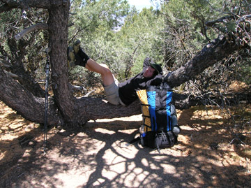
Couldn't pass up this resting spot
The best sunset of the whole trail
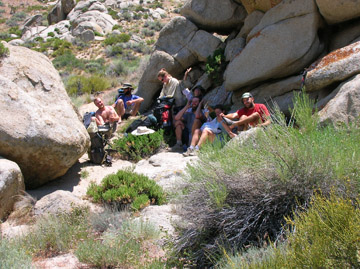
The only shade for miles, and it wasn't much
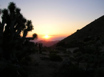
Excellent desert sunset
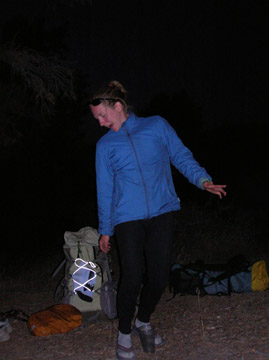
Erika plays "Butt Butt Golf"