Elevation: 6732 ft
Trail Miles: 386 miles
After taking a very relaxing and enjoyable (if not too long) stay in Wrightwood, we started out at 10am. Following two zero days in Wrightwood, Walt took us up to the trail.
An overview of our stay:
Arrive early, catch a giant breakfast, meet up with Debi & Jean Luc, find a place to stay, do laundry, nap, and then bring on the social time. The most hikers I have seen so far gathered in Wrightwood. One evening the owner of the hotel bought a bunch of beer and snacks and invited us all to sit with him for drinks. Toward the end of the evening there was nearly 20 thru-hikers not feeling ready to hike in the morning. Then there was sleep, postal service, grocery shopping, and a little more R&R before rolling out in the next morning.
After Walt dropped us off we had a six mile hike to the crossing with Highway 2. We could camp there and attempt to summit Mt. Badin-Powell, or walk the closed highway. Based on the plethora of information regarding the over-snowed mountain pass, we opted to take the highway.
Highway walks generally are hard on the body because of the hard pavement, but we were quite happy to be taking the road. The road was covered with massive landslides that we had to navigate through. The road wound into snowdrifts that were as much as 12 feet deep.
Crossing snowfields and landslides we worked our way up and over Dawsons Pass at 7900 ft. Winding back down the Mountain we hit more landslides. The closed highway had boulders on it bigger than cars. But typically the road was just covered in thousands of small rocks, making our traverse very non-linear.
After much slower navigation than we anticipated we arrived at a decent camping spot. With many mosquitos, I decided to pitch the tent. Just as I was getting started, the tent pole snapped. I guess I am going to being sleeping under the stars for the next few nights. Hopefully I can get it replaced in Agua Dulce, and more importantly I hope the next few nights are dry.
May 28th Evening
Elevation: 5366 ft
Trail Miles: 406 Miles
Today is our one month anniversary. We have averaged 13.5 miles a day, 16.25 miles without the zero days. Not to bad, but nowhere near where it needs to be. Oh well, it is just the first month, we will get better, and the days are still getting longer.
Todays hike was nostalgic. Being a holiday weekend, there were several people hiking. We wandered back and forth across Highway 2. Starting early we walked a few miles on highway 2 through a couple of tunnels to connect back with the trail.
Once on the trail, we would occassionally come across weekend hikers. Twice we passed by Boy Scouts out on a weekend hike. I looked at the kids as we passed them, seeing the hot fatigue in their faces. I wondered if they were enjoying the hike on the same level I was. Then I wondered how I must have looked when I was a young scout backpacking. I recall my trips with fond memories, and painful blisters. But I also was not hiking in such hot arid conditions as a kid.
While hiking along the decomposed granite trail, we slowly dropped away from the treeline. While we are still camped among a few trees, I can already feel the changes to come as we drop down to the Antelope Valley and the Mojave Desert. As we wound among the trail and trees I noticed extra large spikey Coulter Pine pinecones. My mom would often collect these pinecones for table decorations. I thought of taking one to send her, but the size and weight seemed to be excessive for carrying.
Toward the end of the day, I was hoping to run into someone with a phone so that I could email an order for another tentpole. The people I asked told me they did not get reception up here, but there was a diner a couple miles down the road.
Jon, Debi, and I stashed our packs and decided to get a 400 mile beer, and send out an email. Not too far down the road we were picked up by some day hikers who were also going to the diner. Thanking them for the ride we offered to buy them a drink, but instead they bought us a pitcher and joined us for dinner. They then took us back to where we stashed our bags. Thank you Sean and Michelle.
After the pizza and beer we returned to hike another four miles to camp. Shortly after returning to the trail, we saw a Coral or Racer Snake (?). After trying to remember if it is "Red touches Black look out Jack" or "Red touches yellow look out fellow" the snake worked his way off the trail and we made a safe passing.
Catching up with "Nabor J" and "Chowder" we told them of our adventure as they cooked up some pasta. Now I lay on the ground without a tent feeling the dew collect on my bag. Only 2 more nights until I can get my tent fixed.
May 29th Evening
Elevation: 6550 ft
Trail Miles: 430 miles
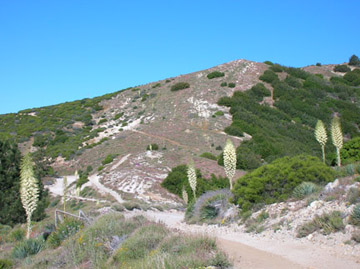
I left before everyone today and hiked alone for most of the day. I hadn't planned on that, I was just ready to go. We climbed out of the semi-desert floor back up into the hills where the trail was a well manicured pine duff. I hiked past several Yuccas in bloom, a tall magnificent desert plant that takes 20 years to bloom and then it dies.
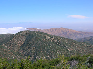
Once up in the higher grounds again, I was walking among the Big Cone Spruce trees. I could have looked down over the desert floor I am soon to cross, but nature was blessing the hikers a few days ahead of me. Antelope Valley and the Mojave was completely blanketed in a vast white cloud.
After covering 13 miles in a short 4.5 hours, I took a lunch at a nearby Ranger Station. To get out of the heat, us thru-hikers huddled behind one of the few buildings we had access to, the public restrooms. Slowly more thru-hikers piled in and the nine of us sat cooking our lunches behind the bathroom. We cooked our meal there to save water on the long dry stretch ahead.
Fed and rested, I set out with plans of hiking 17 more miles to the next water source. Unfortunately, my body had other plans. As I started up the hill, my calf started to cramp up real bad. I continued hiking with the sore leg, but knew my pace was slowed too much to go 17 miles by sunset.
As I climbed in elevation again up into more spruce trees and Jeffrey Pines I ceded to doing 10 of the 17 miles. I slowed my pace to let Jon and Debi catch up. The three of us slowly climbed up to the crest of the hill, where we decided to make camp. One mile further would be a campground, but probably crowded with weekend campers. Generally weekend campers are fun to talk to but hard to sleep near, since they talk late into the night and we rise early with the sun.
After the big lunch we only had a snack for dinner. Now with a cold wind blowing, the three of us watched the sun set over the hills we will be hiking down tomorrow. Hopefully the wind will stop soon, as I am without a tent and rather chilly.
May 30th Evening
Elevation: 2500 ft (?)
Trail Miles: 454
Today was a good day. Coming down off the hill, I looked at the landscape, a brillent paper machier work of green and brown paint. After rising early and doing a quick seven mile hike to the next ranger station we had a second breakfast. ("I don't think he knows about second breakfast"). I ate six oatmeals to tide me over until first lunch. Mmmm.
My calf was still hurting, and I tried catching a ride into the next stop, but failed. That was a good thing. As I descended out of the San Gabriel Mountains, I decided to run a bit since my pack was light.
As I rounded a corner I looked up and saw a mountain lion cub. Not liking the idea of being mauled by the mother mountain lion, I pulled out my knife, just in case. Luckily I passed without incident. Slowly we made our decent out of the mountains. As we came down into the RV park full of holiday campers, I was looking forward to finding fresh beverages and barbecued food. Instead, I relaxed in the shade, filled up with water and carried on.
As Jon and Debi decided to hike the ten miles to the Saufleys, I decided to road walk the ten miles. My calf was sore, and I decided an even grade road walk would be easier on the legs. While it hurts the feet alot more, the calf was getting descent rest.
I set out to walk alone along the highway, trying to hitch a ride. I managed to snag a ride for half a mile to the turn off. So then I started hiking up Agua Dulce Canyon Rd to get to the Saufleys. Again near the end of the hike, I got a ride for a mile before the next turn.
I opted to walk the rest of the way. As I pulled into the house I was greeted with great enthusiasm from all the hikers ahead of me. I can not describe the heaven that is the Saufleys Residence, but I will attempt.
Once here, my pack was set down, and I had a beer. Donna Saufley took all my clothes to run through the wash. I showered and changed into clothes they had for thru-hikers. We started a barbecue and the rest of the day has been spent catching up with thru-hikers. The Saufleys have three tents with cots, two houses and a trailer and hammocks for hikers to crash in. Not only was I greeted with love, Sean and Michelle (the ones who hitched us in for Pizza and beer two days ago) had sent a box of cookies for Jon, Debi, and I. (Magnificent trail angels ...thank you thank you you).
Now I will be social and relax. Tomorrow will be a zero-day for sure.
Happy Trails, Inner Peace, & Harmony
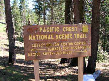
373 Miles in, there is a sign.
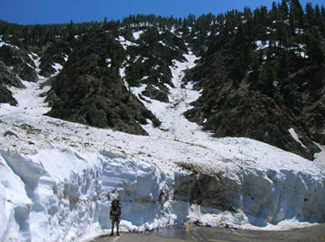
Yep, thats me and about 15 feet of snow over the road
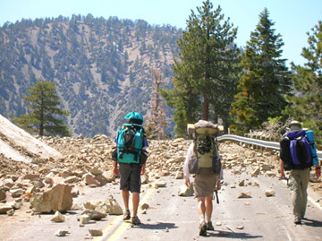
About 10 miles of closed highway due to landslides
Clouds over Antelope Valley