 |
|
|
|
|
|
|
|
|
|
|
|
|
|
|
|
|
|
|
|
|
|
|
|
|
|
|
|
|
|
|
|
|
|
|
|
|
|
|
|
|
|
|
|
|
|
|
|
|
|
|
|
|
|
|
|
|
|
|
|
|
|
|
|
|
|
|
|
|
|
|
|
|
|
|
|
|
|
|
|
|
|
|
|
|
|
|
|
|
|
|
|
|
|
|
|
|
|
|
|
|
|
|
|
|
|
|
|
|
|
|
|
|
|
Info About Towns |
|
|
|
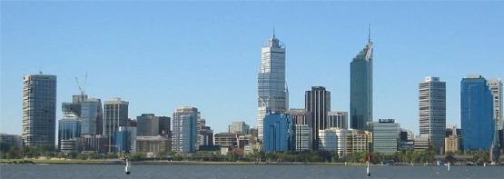
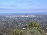
Perth - Western Australia
Perth is located in the Southwest of Australia and is commonly referred to as the �friendly city.� Its the capital city of Western Australia, and is the only real city in the whole massive State. Built on the banks of the Swan River over 150 years ago, the city is a melting pot of many races and creeds, and has traditionally liked to think of its self as a little more independent than the rest of Australia. With its clear skies and sunny climate, (it has over 300 days of sunshine each year!)
|
|
|
 |
|
|
|
|
|
|
 |
|
|
Population
Western Australia: 1,831,399
Perth population: 1,400,000 |
|
|
|
|
|
See Map |
|
|
|
|
|
|
Perth to Dunsborough - 307km - 3hours 34mins |
|
|
|
|
|
|
|
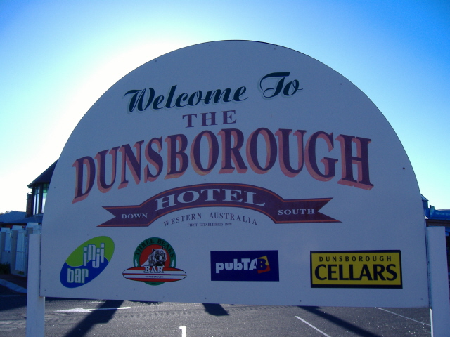
Dunsborough - Western Australia |
|
|
|
|
|
Located 254 km south of Perth and 26 km east of Busselton, Dunsborough is a small resort town which stands at the entrance of the dramatically beautiful Leeuwin Naturaliste National Park. The appeal of the area is that it has so much to offer people who love coastal scenery, bush walks, wildflower displays and untouched rugged coastlines. |
|
|
|
 |
|
|
Population
Dunsborough - 4000 |
|
|
|
|
|
|
Dunsborough - Pemberton 175km - 2hours 30mins |
|
|
|
|
|
|
|
Pemberton - Western Australia |
|
|
|
|
|
Nestled in the valley surrounded by the karri forests of the Gloucester National Park and the Pemberton Forest Park, Pemberton enjoys a cool Mediterranean climate with crystal clear streams, rich soils and friendly locals. The town began as a timber town and was established in 1913. Before then, cattlemen and farmers had sparsely populated the surrounding country and the town's name comes from one of the earliest settlers, Pemberton Walcott. Pemberton is located 335 kilometres south of Perth via South West Highway. |
|
|
|
 |
|
|
Population
Pemberton - 3000 |
|
|
|
|
|
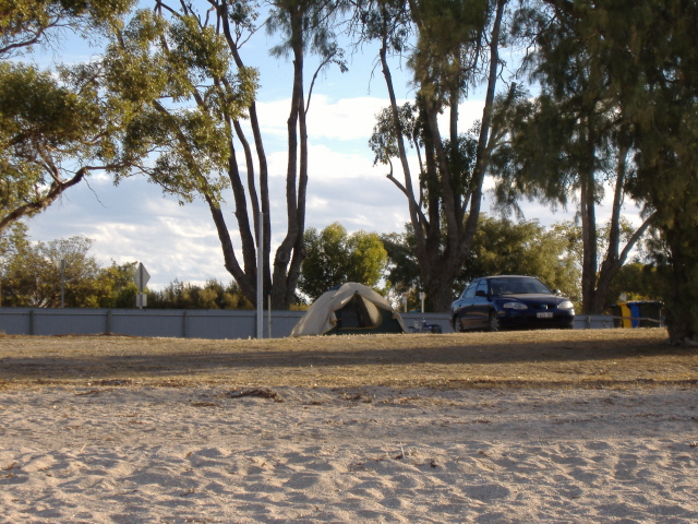
Home sweet home!!!
(for the next month anyway.) |
|
|
|
|
|
|
Pemberton - Bremmer Bay 455km - 6hours 10mins |
|
|
|
|
|
Bremer Bay - Western Australia |
|
|
|
|
|
Bremer Bay is located 180kms east of Albany, on the South Coast of Western Australia. Bremer Bay is a wide expanse of crystal clear azure blue water, and an endless stretch of striking white sand. From approximately July to November each year. Southern Right whales calve in the calm waters of the numerous sheltered bays in the area. Point Anne provides a whale watching platform. Occasionally, humpback whales can be seen from a distance as well as other marine visitors such as dolphins and seals.
|
|
|
|
 |
|
|
Population
Bremer Bay - 250 |
|
|
|
|
|
|
Bremmer Bay - Esperence 424km - 5hours 5mins |
|
|
|
Esperance - Western Australia |
|
|
|
|
|
|
|
|
|
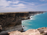
Esperance is situated on the south coast of Australia's Golden Outback tourist region. Esperance faces south to the Southern Ocean and is protected by over 200 islands of the Recherche Archipelago in the Bay of Isles. Many sheltered bays surround the town.
Esperance is the place to be if you are wanting to discover the best looking beaches with the most colourful, tranquil blue water that you will ever see in your life. The many bays around Esperance are absolutely stunning to say the least. The waters are calm and shallow and are great for swimming and snorkelling. The Rocherche Archipelago lies just off the coast consisting of over 200 rocky islands which is abundant with wildlife. The surrounding hinterland offers beautiful national parks and the town itself has a very relaxed feel. |
|
|
|
Population
Esperance - 13329 |
|
|
|
 |
|
|
|
|
|
Esperence - Cocklebiddy 658km - 7hours 20mins |
|
|
|
Cocklebiddy - Western Australia |
|
|
|
|
|
|
|
|
|
Cocklebiddy is situated 64 kilometres east of Caiguna and and 83 kilometres west of Madura. Cocklebiddy lies on the southern edge of Western Australia's truly vast sheep grazing belt. Within the area are several large scale sheep grazing operations, some larger than a number of European countries. During its pioneering years Cocklebiddy was the site of an aboriginal mission. Today however, all that remains of the aboriginal mission are its stone foundations. |
|
|
|
 |
|
|
Population
Cocklebiddy - 6 |
|
|
|
|
|
|
Cocklebiddy - Nullarbor 486km - 8hours 50mins |
|
|
|
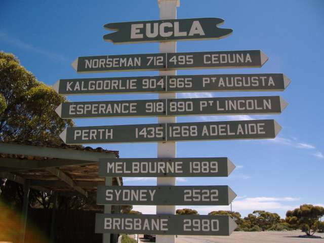
Nullarbor Roadhouse - South Australia |
|
|
|
|
|
|
|
|
|
Nullarbor Roadhouse is located 94 kilometres west of Yalata, 187 kilometres east of Border Village, and 201 kilometres east of Eucla. In 1866 E. Alfred Delisser surveyed the Nullarbor Plain and noted a marked absence of trees. Contrary to some popular opinions the word Nullarbor is not of Aboriginal origins. In fact the local Mirning people referred to the area as "Oondiri" which is said to mean "the waterless". Delisser derived the term Nullarbor from the Latin "nulla" for no, and "arbor" for tree. Hence the term Nullarbor meaning no trees. |
|
|
|
 |
|
|
Population
Nullarbor - 9 |
|
|
|
|
|
|
Nullarbor - Streaky Bay 437km - 6hours 20mins |
|
|
|
Streaky Bay - South Australia |
|
|
|
|
|
|
|
|
|
Streaky Bay is a picturesque coastal resort which acts as a service centre for the surrounding rural community, with wheat, barley, wool and fat lambs being the main activity on the land. Also cattle, pigs and poultry contribute to a lesser extent to the general economy of the area.
Granite mining is now a significant industry. Matthew Flinders, who in 1802 explored the southern coast, named Streaky Bay after the bands of colour in the water which he thought may have been caused by a large river entering the ocean, but in fact are made by oils given off by the seaweed. |
|
|
|
Population
Streaky Bay - 1200 |
|
|
|
 |
|
|
|
|
 |
|
|
|
|
|
|
|
|
Streaky Bay - Port Lincoln 439km - 7hours 00mins |
|
|
|
Port Lincoln - South Australia |
|
|
|
|
|
|
|
|
|
A substantial fishing township on the southern edge of the Eyre Peninsula
Port Lincoln really is the keystone of the Eyre Peninsula. A substantial city located on Boston Bay (a bay which is more than three and a half times the size of Sydney Harbour) and nestled in on the easterly side of the Eyre Peninsula over the years it has become the most important grain and fishing port in the region. As a result it has become the informal capital of the whole peninsula.
Port Lincoln is located 656 km west of Adelaide, has a population of over 13 000, a rainfall of 488mm per annum, and enjoys a near-perfect Mediterranean climate. It is a large and reasonably sophisticated centre which is economically driven by the huge grain-handling facilities (the foreshore is dominated by the 47-metre-high grain silos which have a total capacity of over 337 500 tonnes), the canning and fish processing works, lambs, wool and beef, fertiliser production and, in recent times, the vast wealth which has been made as a result of tuna farming for the lucrative Japanese market. It currently boasts Australia's largest commercial fishing fleet and fish farming has become so important that Port Lincoln now has kingfish farms, mussel farms, oyster farms, experimental lobster farms and abalone farms. |
|
|
|
Population
Port Lincoln - 13552 |
|
|
|
Port Lincoln - Port Pirie 427km - 5hours 40mins |
|
|
|
Port Pirie - South Australia |
|
|
|
|
|
|
|
|
|
Port Pirie
is a Large industrial centre on the shores of Spencer Gulf
Located on the eastern shore of Spencer Gulf 229 km north of Adelaide, Port Pirie economy is driven by the huge silver, lead and zinc smelters which process the raw ore brought from Broken Hill and the large port which provides transportation for both the metal and rural industries which dominate the town. Port Pirie proudly announces itself as 'The City of Friendly People' (Yeah Right!!!) although the first sight one has is not of people but of the huge oil tanks on the outskirts of town and the grain silos and the chimney at the smelter. It would be easy for the traveller to feel that here was a big smelly industrial city and keep driving but this would be to miss some fascinating buildings and a genuinely beautiful and gracious main street. (I�ll cope with missing it!!!) |
|
|
|
Population
Port Pirie - 17074 |
|
|
|
Port Pirie - Adelaide 245km - 3hours 30mins |
|
|
|
Adelaide - South Australia |
|
|
|
|
|
|
|
|
|
Adelaide is a city of great visual harmony and classical elegant style, superbly set beside the River Torrens between the Adelaide Hills and waters of Gulf St Vincent.
The wine and festival capital of Australia, Adelaide is a place to experience the buzz, culture and convenience of a big city without the frustrations. The city centre, surrounded by parklands, is a charming blend of historic buildings, wide streets, groovy shops, street cafes and restaurants. And because Adelaide is known as the 20-minute city, you can experience it all on a series of easy short walks. Your food and wine experience begins right in the city centre with the Adelaide Central Market; vibrant cafes and restaurants boasting some of Australia�s best chefs; and events such as Tasting Australia. You'll find a mix of restaurant strips dotted right across the city. |
|
|
|
 |
|
|
Population
Adelaide - 1100000 |
|
|
|
|
|
|
|
|
|
|
Adelaide - Robe (via Hills) 421km - 6hours 15mins |
|
|
|
|
|
Robe - South Australia |
|
|
|
Robe is situated along the Limestone Coast, of the South East of South Australia.
The heritage centre of seafood, wine and coastal delight, Robe is the preferred destination for visitors who enjoy a relaxing coastal retreat that offers fresh local gourmet produce and wine. Robe is located in Australia 340 kms South East of Adelaide, South Australia and 580 kms North West of Melbourne, Victoria. |
|
|
|
Population
Robe - 742 |
|
|
|
Robe - Warrnambool 345km - 4hours 20mins |
|
|
|
Warrnambool - Victoria |
|
|
|
Warrnambool is a coastal city located on Lady Bay 260 km south-west of Melbourne via the Princes Highway and 21 metres above sea-level. It is bounded by two rivers: the Merri to the west and the Hopkins to the east. Both reach the ocean on opposite sides of the city. Warrnambool is an important manufacturing and distribution centre although it has managed to retain a relaxed seaside feel. Its natural advantages render it a popular family destination in summer and tourism is certainly a major aid to the local economy. |
|
|
|
Population
Warrnambool - 28000 |
|
|
|
Warrnambool - Lorne (The Great Ocean Road) 220km- 6hours10mins |
|
|
|
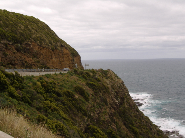
The Great Ocean Road - Victoria |
|
|
|
Australia's Great Ocean Road ranks among the world's most stunning scenic coastal drives: Huge cliffs, raging surf, tranquil bays, beautiful beaches, lush forests, fun-filled resort towns are all part of the experience.
But creating the road was no easy task. It took the famous Aussie fighting Anzac spirit to blast the roadway into ledges above 100-metre cliffs and drive it over dense
bush-covered mountains.
Nearly 3000 returned soldiers from the First World War toiled on the 14-year project, which is dedicated as a memorial to their colleagues who died in the war.
Take a virtual trip down the road to discover more about its fascinating past. |
|
|
|
 |
|
|
|
Lorne - Philip Island (Via Melborne) 247km- 5hours 50mins |
|
|
|
Philip Island - Victoria |
|
|
|
Phillip Island is famous for its little penguin colony and the Grand Prix Track.
Located only 124 km south of Melbourne, at the entrance to Westernport, Phillip Island is a popular day trip from Melbourne. It is connected to the mainland by a 640-metre long bridge at San Remo which, in 1969, replaced an older suspension bridge.
Phillip Island covers some 10 000 hectares. It is 26 km long and 9 km wide and consists largely of open and flat countryside. The permanent population, in the off-season, is some 5500 but the island currently attracts some 3.5 million visitors each year which makes it the most popular single tourist destination in Australia.
The Penguin Parade
The little penguins, native to Australia, are the smallest of their species, growing to a mere 33 cm in height. They possess waterproof feathers and are most plentiful in summer when they are rearing their young. Each evening, just on dusk, thousands of little penguins make their way back to their burrows in the sand dunes at the back of Summerland Beach. The penguins go out to sea each day to catch food (mostly pilchards and other small fish) for themselves and their young. They return to the beach in 'rafts' (groups - sometimes of only a few, sometimes of some dozens) and make their way up the beach to their nests where they lay a couple of eggs which take about six weeks to hatch. The chicks remain in the nest for two months. |
|
|
|
Population
Philip Island - 5500 |
|
|
|
Philip Island - Tathra 572km-6hours 45mins |
|
|
|
Tathra - New South Wales |
|
|
|
Set like a gem into shades of green and blue, Tathra surrounds itself in the natural beauty of both Mimosa Rocks National Park to the north, and Bournda National Park to the south, home to many seabirds such as the endangered little tern and an abundance of wildlife. Fur seals and fairy penguins from the colony on Montague Island sometimes frequent the waters around the Wharf and are quite willing to let you be a part of their underwater world. Dolphins are also common visitors to this area and they can be seen off most beach areas in Tathra. Tathra Beach meanders 3km around the shoreline, patrolled in summer and protected from southerly winds making it great for surf, board riding and sailboarding. |
|
|
|
Population
Tathra - 5325 |
|
|
|
Tathra - Wollongong 304km- 5hours 20mins |
|
|
|
Wollongong - New South Wales |
|
|
|
The Illawarra Region lies just an hour south of Sydney, and stretches from the Royal National Park to the Shoalhaven River, and encompasses the City of Wollongong. Originally famed for its coal mining & steal production, this region now boast a lively university, 5 star hotels, guesthouses, galleries and beautiful beaches. |
|
|
|
Population
Wollongong - 219750 |
|