 |
| Diving Sites in Malta |
|
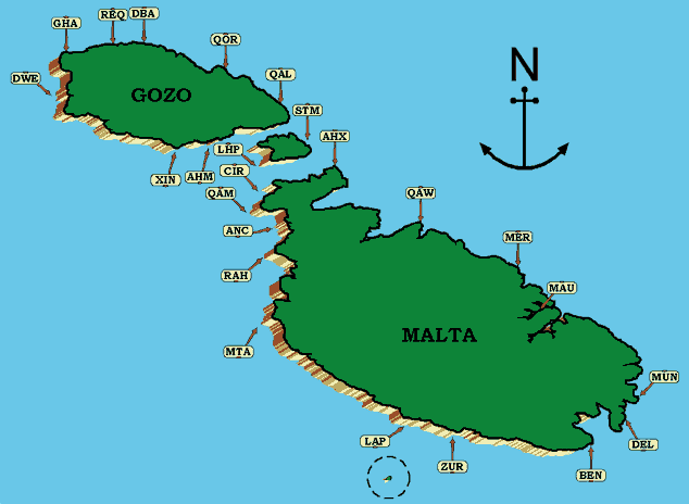
| AHX ---- AHRAX TAL-MELLIEHA Location: North East tip of Malta (beyond Armier) Facing: North-East Type: Shore dive Depth: 15-35 meters Entry: Easy - walk off rocky beach but beware of tar on the rocks at foreshore. Navigation: Snorkel out bearing 000 for 50-100 meters. The bottom is covered in posidonia starting with sand and gradually rocks with many crevices holes and overhangs (home to octopus and cray-fish). Continuing on this course will eventually bring you to the edge of a drop off down to a flat sandy bottom (around 35 meters) with large boulders. The wall is covered with colourful sponges. Swimming along to the right takes you along a meandering wall. About 200 meters along the wall from the North-Eastern-most tip of the bay (and island) is a shallow entrance into an open arena of sheer rock face. Take a break - surface and enjoy the spectacle before setting back. An alternative route is to dive along the drop off to the left and enjoy the marine life in crevices and overhangs. The drop-off continues for several hundred meters therefore it is important to leave enough time to navigate back to the entry point. Instead of snorkelling out, the bay itself is a pleasant dive in itself - the sides of the bay are V-shaped one side pointing North and the other NW. WARNING This dive site is prone to strong currents along and above the drop-off. |
| QAW ----- QAWRA POINT Location: The outer-most tip of the Bugibba/Qawra peninsula Facing: North-East Type: Shore dive Depth: 15-40 meters Entry: Walk off rocky beach. Hard-sole booties essential - the rocks are sharp. Do not attempt the dive if the waves are breaking at the entry point. Navigation: From the car-park below the Fra Ben Restaurant the peninsula continues but is not easily accessible. The bay on the South-East side is shallow (5 meters max) and covered in posidonia - hardly worth the bother unless your practising mask clearing. On the NW side, several alternatives are definitely worthwhile. A dive along the shore takes you into a small cavern with an open ceiling. A torch light is required. The underwater terrain in interesting with many crevices and rock formations but does not go deeper than 15 meters for quite a distance. Taking a bearing due North brings you to a drop off onto a flat sandy bottom. Swim along the drop off for a wall of nooks and crannies full of colourful sponges and small marine life. Many small caverns are home to larger fish. WARNING Do not enter into the caverns. Most are narrow, small and full of silt. Fatal accidents have occurred here. Another alternative requires a long (100 meter) snorkel on a bearing of 015 from the entry point. Dive and continue on this bearing. Reaching the top of the drop off and continuing on a North East direction, the bottom is deeper (down to 45 meters) and large boulders make the terrain more interesting and the marine life more abundant.. A local dive leader will be able to show you a large cavern open at both ends. |
| MAU ------ HMS MAORI Location: Marsamxetto Creek - off Valletta Bastions facing Sliema Facing: North Type: Shore dive Max. depth: 15 meters Entry: Easy - walk off jetty down the stairs from road level Navigation: Before kitting up, look along the pavement on the sea side of the road. You should be able to see a foot long piece of metal waterpipe sticking out of the ground! Stand by the pipe, positioning yourself so that the big tunnel in the bastion face is directly behind you. Take a bearing straight out to sea, drawing a straight line from the tunnel through your body and over the pipe. That's your bearing!!!! What's left of the the Maori is lying upright on the sand with the depth on her starboard side being aproximately 16 meters deep and on her port side about 12 meters deep. Once you navigate out from the entry point you will come across a drop-off following the contours of the bay. On the seaward side the bottom is sand. Follow the drop off to the west and you will eventually arrive on the Maori. The first thing you will notice is the hole in her starboard bow, close to her winches. As you travel down her length you will notice large round "hatches" with brass rims. These were her gun mountings. Next come the remains of her super structure with another gun mount on top. After this you will only find debris. This is because she was actually broken in two and only her forward section remains! This has the advantage that entry is possible without the possibility of getting lost. In addition plenty of light comes in through some missing side panels as well as through various hatches leading to her deck. Wreck penetration should not be attempted without previous training and experience. WARNING Beware of theft from unattended cars. Rough neighbourhood. |
| MUN ---- MUNXAR REEF Location: A reef jutting out from the Eastern-most point of Malta Facing: East Type: Boat dive Max. depth: 35 meters Navigation: Anchor about 10 meters to the west of the cardinal buoy marking the extreme tip of the reef. You should find yourself over a drop off. Follow the drop off to the left and you will soon come across an "arch" in the face. Entry is possible from 35 meters on the bottom with the exit being a hole in a "dip" on the reef top at about 27 meters. A very picturesque dive wit lots of old fishermen's nets hanging off the craggy drop off. Beware of occasional currents. |
| DEL --- DELIMARA POINT Location: South-Eastern-most point of Malta Facing: South-East Type: Shore dive Max. depth: 15 meters Entry: The parking lot at the road side close to the lighthouse is the best place to kit up. The entry point is about 150 meters away, out towards the headland pointing East. Navigation: The shore dips into the sea but continues out at a depth as shallow as a couple of meters rising from a depth of about 15 meters. The reef is bright and rich in colourful fauna, though not commonly home to large fish. Heading in a South-Easterly direction along the reef drop-off presents the most attractive profile. The return journey should be on a reciprocal bearing but at a shallow depth running along the top edge of the drop-off. |
| BEN --- BEHGHAJSA POINT Location: A reef off the South Eastern tip of Malta stretching 1.5 Km out. Facing: South East Type: Boat dive Max. depth: 50 meters Entry:The best diving is at the tip of the reef where the depth is as little as 7 meters in places. Navigation: The southern side of the reef offers some interesting drop-offs with the maximum depth at the base of the tip being 45 to 50 meters. The large shoals of Damsel fish attract many large Amberjack who feed on them. There is a large anchor at the very tip and stories abound of a WW2 plane wreck somewhere on this side of the reef. |
| ZUR --- WIED IZ-ZURRIEQ Location: A creek at the Southern side of the island near the famed Blue Grotto Facing: South-South-West Type: Shore dive Wied iz-Zurrieq is a much frequented dive site notably during a North West swell because it is sheltered. It offers a variety of dive profiles and underwater terrain. Access is easiest from the concrete quay within the inlet. Beware of fishing boats used to ferry tourists on sight-seeing trips and avoid entry near fishermen angling off the quay. There is now a wreck at Zurrieq -- Um el Farrud . Its at around 150m from the shore at a maximum depth of aroung 40m. Its 110m long and can be easily reached from the shore too. Exit is from a slipway further in at the end of the quay. Maximum attention is important when surfacing as this area is used for launching fishing boats and embarking tourist passengers. |
| LAP --- GHAR-LAPSI Location: A small inlet among the high cliffs on the South Western face of Malta. A restaurant, car park, public convenience and even swings are at road level. A charming bay naturally enclosed by an arm of rock is at the bottom of a steep hill but stairs and hand-rail save the day. Facing: South West Type: Shore dive Max. depth: 20 meters Entry: It is possible to walk into the shallow or to walk off the small jetty into 3 meters of water. Good navigation is needed to find the entrance to the bay on the way back. Navigation: Once in the bay, it is possible to move out through the mouth towards the South or through a narrow channel at the North corner. The scenery beyond is mostly white sand with occasional rock outcrops. Taking a South-West (225) course for about 150 meters gets you to a reef running parallel to the shoreline. The reef rises from a depth of 15 meters up to 5 meters. It is rich with overhangs hiding colourful sponges, coral and small fish. |
| MTA --- MTAHLEB Location: Nested at the bottom of a narrow gorge carved among the highest cliffs on the South West side of Malta. Facing: South-West Type: Shore dive Max. depth: 50 meters Entry: A long steep walk down a narrow path to the rocky shore. Inaccessible in a South-West swell. The dive is spectacular but the climb back to the top is not for the faint hearted. Navigation: This dive is frequented mostly for depth. It is one of the deepest spots accessible from shore in Malta. The sea bed slopes sharply to 50 meters and beyond. The Northern side of the cliff wall is full of crevices where the occasional lobster can be sighted. The top of the wall is a wide shelf at about 15 meters which is strewn with cars! This is a spot where unwanted vehicles find their end. Many clay pigeons (which got away) are also sprinkled around the shallows - evidence of a shooting range close by. |
| RAH --- RAS IR-RAHEB Location: A headland jutting out at the Westernmost point of Malta. Facing: West Type: Boat dive Max. depth: 70 + meters Entry:Anchoring at the point is not really possible due to the cliffs plunging vertically to a depth of sixty meters. Navigation: The cox should lay the divers close to the cliff and the dive consists of choosing your depth and following the wall to the west until you enter "Fomm ir-Rih" bay and find yourself in up to 20 meters of water. The sheer cliff face can be disorientating due to the clarity and deep blue of the water. Fish life consists of any pelagics passing by and various wrasse and parrot fish that roam the wall. |
| ANC --- ANCHOR BAY Location: A narrow inlet below the famed Popeye Village. Facing: West Type: Shore dive Max. depth: 15 meters Entry: A jetty juts out across the bay. The inside is mostly a sandy boring sea bed. Striding off towards the mouth of the bay is the recommended option. The jetty has steps down to sea level at several points making it easy to enter and exit. Navigation: The sea bed is covered with rocks and boulders. However, the highlight of this dive is a large cavern on the left hand side wall. The cavern has a huge dome-shaped ceiling with air locked in. Always BEWARE of breathing air inside a cavern - it may not be clean and fit for breathing. Translucent shrimp are very common on the cave floor as well as red soldier fish. Looking out towards the mouth of the cave with lights out presents a beautiful sight. |
| QAM --- RAS IL-QAMMIEH Location: The headland marking the North western-most point of Malta. Facing: North West Type: Boat dive Max. depth: 40 meters Entry: The more popular dive is along the drop-off formed by the southernmost face of the "point". Anchor close to the shore just behind the two large boulders. Navigation: Follow the drop-off at an average depth of thirty meters and you will come across various shallow but mysterious caves. Keep an eye out in the blue because that's where the Amberjacks and Dentex stay. |
| CIR --- CIRKEWWA Location: A North Western outcrop of land next to the Gozo ferry boat quay. Facing: North West Cirkewwa is probably the most popular diving location on the island. It presents a variety of dive profiles making it a common site for beginners as well as for seasoned divers looking for an exciting and beautiful experience. Diffenent dives are possible here. Beginners' Valley Type: Shore dive Max. depth: 6 meters Entry: Just to the left of the main car-park (by the queuing area for boarding the Gozo ferry) is a short path leading to a natural shallow pool - ideal for kitting up! Navigation: Swimming out of this pool a shallow shelf with "valleys" no deeper than 6 meters. This area is often used for training though it is possible to find octopus, small morays and many small fish around the nooks and crannies. It is ideal for getting acquainted with the local ambience. -------------------------------------------------------------------------------- The Drop-off Type: Shore dive Max. depth: 35 meters Entry: Same entry as for Beginners' Valley. Navigation: Just beyond the Beginners' Valley shelf is a drop-off onto sand starting at 17 meters and gently dipping to 35 meters. The wall towards the left is rich in small and colourful marine life with many overhangs and small caverns - most not big enough to fit a diver. The right hand side has a less spectacular wall but presents more variety among the large boulders in the sand just off the drop-off. At 18 meters just off from beginners' valley is a statue of the Madonna in its own little grotto. -------------------------------------------------------------------------------- The Rozi Wreck Type: Shore dive Max. depth: 35 meters Entry: Just behind the car park facing directly to Gozo is an unused iron jetty. A giant stride from the rocks by this jetty puts you in 5 meters of water. The exit is round the headland to the left and up through Beginners' Valley. Navigation: On a bearing of 300 from below the "lighthouse" light the bottom drops off sharply and after about a 100 meters swim, the old tug Rozi sits upright in 36 meters. The boat was sunk as a natural reef and is typically teeming with small and large fish. Close to the bow and on the way back, an old admiralty anchor stands out in solitude. -------------------------------------------------------------------------------- The Arch Type: Shore dive Max. depth: 20 meters Entry: Just past the car park and below the light house tower is a narrow passage leading to the outside of the break-water. Some stairs lead to a concrete landing just above sea level. BEWARE of the slippery surface. Navigation: On entry, follow the drop-off to the right and after 100 meters swim a clearing with a bottom of sand and shells. A natural rock arch encloses an open alcove with the walls full of cracks and small holes - home to numerous fish and cray-fish. The top of the arch is at 10 meters. Shoals of jacks are common in this area adding to the enchanting an tranquil scene. |
| LHP --- LIGHTHOUSE POINT Location: South West tip of Comino Facing: South West Type: Boat dive Max. depth: 40 meters Entry: A narrow needle of rock juts out to the top of a vertical drop to 40 meters and beyond. On the South side a ledge at 10 meters offers good holding ground for anchoring. Navigation: The site is rich in marine life and spectacular rock formations. A maze of swim-through cracks make an interesting tour. It is likely to come across large grouper and dentex close to the sea floor littered with large boulders. Smaller fish are always present in shoals at the shallower depths. The site is prone to strong currents notably after a North West swell. |
| STM --- SANTA MARIA CAVES Location: An inlet on the Eastern side of Comino. Facing: West Type: Boat dive Max. depth: 20 meters Entry: The inlet is flanked by vertical high cliff faces making this location a pleasant anchorage as well as a much sought-after dive spot. Navigation: Before you enter the water, prepare some bread crumbs to feed the teeming shoals of fish which have become accustomed to the feast offered by visitors and will peck bread out of the generous diver's hand. The dive proceeds into the shallow but fairly wide tunnel heading in a Northerly direction. On the outer side, boulders and small rocks provide a varied environment. An alternative to returning back through the tunnel is to circle out and around the rocks in a clockwise direction back to the inlet. The area also presents some interesting rock formations (e.g. a natural arch) and the cliff walls are dotted with crevices. Snorkelling is also rewarding all along the cliff wall heading North and West. |
| QAL --- QALA POINT Location: The Eastern-most tip of Gozo. It is practically inaccessible by land. Facing: East Type: Boat dive Max. depth: 35 meters Entry: The boat should anchor at the top of the drop off in the area below the large limestone quarry visible less than 1 Km inland. Navigation: Starting at the top of the drop off at around 10 meters, a wall dive offers the typical scenery in Maltese waters where crevices and overhangs shelter a variety of small fish and colourful fauna. Below, the bottom slopes off gently strewn with large boulders on a sandy floor |
| QOR --- DAHLET QORROT Location: A quant and quiet bay at the end of a winding road beyond Nadur. Facing: North-East Type: Shore dive Max. depth: 10 meters Entry: Easy access close to the road Navigation: The ambience is less impressive compared to the other sites in Gozo but enjoyable as a shallow easy dive among small rocks on a sandy bottom with plentiful posidonia meadows. |
| DBA --- DOUBLE ARCH Location: Qbajjar - a small bay on the Northern outskirts of Marsalforn. Facing: North Type: Shore dive Max. depth: 40 meters Entry: The rocky shore is covered in salt pans. Entry is from a small inlet with gentle sloping sides. The shore dive is not practical in a Northern swell or current as it involves a significant snorkel out. Navigation: The site is a reef rising out of depths of 40 meters and beyond. It is very rich in marine life and with breath-taking rock formations. Two vertical walls are joined by two horizontal spans of rock at different depths. The reef is about 300 meters off shore. Getting to it from shore involves a snorkel out on a course of 015. Once the reef is reached, circling out to the NW in a clockwise direction at a depth of 30 meters brings the dive to the arches. Large Cerna in the depths and shoals of jacks in mid-water are common. Once beyond, it is recommended to keep to a depth of 15-20 meters giving sufficient air for a submerged swim back to shore. Close to shore, the rocks are sculptured into complex of holes and crevices - octopus are common here. |
| REQ --- REQQA POINT Location: Qbajjar - a small bay on the Northern outskirts of Marsalforn. Facing: North Type: Shore dive Max. depth: 40 meters Entry: The rocky shore is covered in salt pans. Entry is from a small inlet with gentle sloping sides. The shore dive is not practical in a Northern swell or current as it involves a significant snorkel out. Navigation: The site is a reef rising out of depths of 40 meters and beyond. It is very rich in marine life and with breath-taking rock formations. Two vertical walls are joined by two horizontal spans of rock at different depths. The reef is about 300 meters off shore. Getting to it from shore involves a snorkel out on a course of 015. Once the reef is reached, circling out to the NW in a clockwise direction at a depth of 30 meters brings the dive to the arches. Large Cerna in the depths and shoals of jacks in mid-water are common. Once beyond, it is recommended to keep to a depth of 15-20 meters giving sufficient air for a submerged swim back to shore. Close to shore, the rocks are sculptured into complex of holes and crevices - octopus are common here. |
| GHA --- GHASRI VALLEY Location: A narrow winding creek beyond Ghasri village. Facing: North Type: Shore dive Max. depth: 40 meters Entry: There are stairs on the East side of the creek leading to the shore. Kit up at the top and walk down the stairs carefully. Entry is a simple walk into the shallow water. A snorkel out helps to gain some depth before starting the dive. A Northerly swell makes this dive inaccessible as the waves build up speed and force as they funnel into the creek. Up to a couple of days after rain, visibility tends to be very poor as sediment washed down the valley takes a while to deposit. Navigation: The most attractive course is keeping to the wall on the right hand side. The bottom drops of steeply once out of the creek and most of the dive should be in mid-water. Large fish are common and shoals of smaller fish tend to swim nearer the surface. Just beyond the mouth of the valley and to the right is an interesting large dome-shaped cavern with a small air-lock. It is not recommended to surface in the cavern. |
| DWE --- DWEJRA Location: West of Gozo beyond the village of St Lawrenz Facing: West Dwejra offers a number of alternative dive sites: The Blue Hole Type: Shore dive Max. depth: 35 meters Entry from shore: A 10 minute walk from the car park over large rocks. Close to the water rocks are sharp and other parts slippery. Enter through the mouth of the Blue Hole - worth the walk ! Navigation: The Blue Hole is one of the most beautiful dives of the Maltese Islands. On entry though a circular mouth barely above sea level, the descent to 15 meters is flanked on all but one side by walls covered with colourful polyps, sponges and other small marine life. On the inland side a large cavern with a sandy bottom should be kept in mind for a visit on the way back. The seaward side is a wide opening topped by an arch stopping 1 meter below sea level. The diver is drawn out into the blue yonder with a sense of awe. Beyond the large boulders just outside the hole the bottom drops off sharply beyond 50 meters. One option is a relatively shallow dive out along the right hand side wall which is the foot of the Azure Window. Alternatively, navigating along the left hand wall will offer deeper diving with a better chance of seeing larger fish such as grouper and dentex. A vertical crack leads in towards the land and presents a narrow but interesting passage from the depth of 25 meters up to 5 meters. -------------------------------------------------------------------------------- The Inland Sea Type: Shore dive Max. depth: 45 meters Entry from shore: Just beyond the chapel at the Dwejra car park, a narrow path leads to the semi-circular bay cut off from the sea by a high slice of cliff with a narrow exit at the centre. Two concrete jetties are useful for access but beware of slippery surfaces. The inlet is generally shallow (0.5 - 2.0 meters) and covered with pebbles and small rocks. The inlet is used by local fishermen who keep their small boats in the garages along the shore. The boats are also used to ferry tourists out on sight seeing short trips. Keep to the side while within the inlet and then dive and keep to the bottom while swimming out of the creek. Surface with care. Navigation: The natural beauty of the Inland Sea is matched underwater by a breath-taking journey through a narrow dipping creek with a pebble bottom and out into a boulder strewn area falling beyond 50 meters, home to large fish. The walls to the left and right are also attractive with plenty of colourful crevices and overhangs. The visibility is generally excellent except after rain when sediment reduces conditions significantly. -------------------------------------------------------------------------------- Crocodile Rock Type: Shore dive Max. depth: 45 meters Entry from shore: Looking out to see due west, a small rock outcrop about 100 meters off shore looks like a large model of a crocodile head barely breaking the surface. This is the crest of a pinnacle rock rising from depths of 40 metes. The best way to get to the rock is by entering off the rocky headland closest to it. Entry is by a giant stride off the rocks. Exit is easiest further in along the creek where a slip way and stairs are convenient. Navigation: Heading due west along the drop off leading from the shore, the dive is guided to the crocodile rock which is full of nooks and crannies - home to a variety of fish, small and large. Barracuda have occasionally been sited in this area. -------------------------------------------------------------------------------- Fungus Rock Type: Shore dive Max. depth: 35 meters Entry from shore: Fungus rock is the large imposing islet - forbidden in centuries gone by. The best way to get to the rock is by entering off the rocky headland closest to it. Entry is by a giant stride off the rocks. Exit is easiest further in along the creek where a slip way and stairs are convenient. Navigation: The dive involves quite a snorkel on the inside of Fungus Rock. The outside edge of the rock is a sheer face dropping to 40 meters and beyond - home to many large groupers and other sizeable fish. Further along the wall to the North is a cavern with massive gallery and mouth. The ceiling and walls are covered with red coral. The cave deserves a special dive to itself. |
| XIN --- MGARR IX-XINI Location: A narrow creek below Ta' Cenc cliffs Facing: South Type: Boat dive Max. depth: 30 meters Entry: The creek is a restricted area and diving is forbidden. A free-standing rock just outside the mouth of the creek presents an interesting dive at alternative depths. The rock is a pinnacle with the deepest spot at around 35 meters and the shallowest rising to 15 meters. Navigation: The dive is a simple circumnavigation. The Western side is shallower and ideal for anchoring. Taking an anti-clockwise direction leads the dive to the deeper side of the rock where large fish may be sighted. The dive may progress gradually rising to shallower depths where the scenery changes with more light, colourful overhangs and crevices are home to small fish. |
| AHM --- XATT L-AHMAR Location: A small bay at the end of a winding rough road beyond Xewkija Facing: South Type: Shore dive Max. depth: 40 meters Entry: Easy - walk off rocky beach Navigation: The bay is shallow and boring but swimming out to the South edge of the bay, a shallow bank gives way to a pleasant drop-off with plenty of nooks and crannies. The site is now very popular because of the new sunken wreck MV Xlendi , an ex-Gozo channel ferry boat. It's easily reached from the shore and makes a good wreck dive. |