|
Simcity Eldorado Watch a Flash of Simcity Design
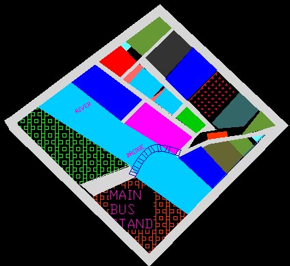
Divided in 3 parts: Residential, Zone 31
Click on the drawings to see full view.
1 Introductory. 2. General idea of a city. 3. Rectangular Road system 3.1 Position of circular centers. 3.2 Combination of National Highway and rectangular street systems. 4. Size of blocks between streets. 5.. Buildings. 6. Theory of aspect. 7. The aesthetics of design. 8. Mathematical calculations 8.1 Distribution of population 8.2 Educational Institutes 8.3 Holy Places 8.4 Means of Transport 8.5 Law and Order 8.6 Water management 9. Hygienic elements of design.
1. Introduction A city is well designed if it has well distributed and managed transport and road system, a perfect sewage system, a perfect place for people of varying economic standards ,a good network of law enforcing units , a well division of health facilities into various parts of the city and lot more and places for entertainment.
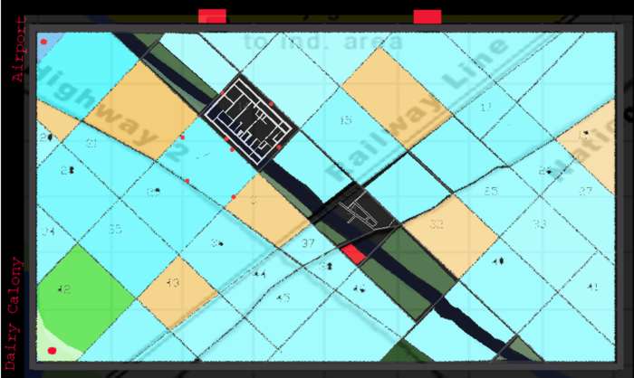
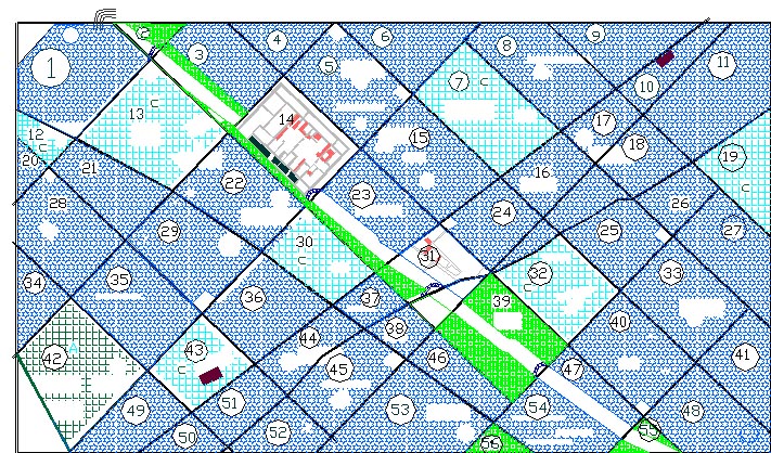
2. General Idea of Eldorado Our city is well divided into 56 sectors .Each sector is further designated as commercial, residential and agriculture, according to the prominence of respective utilities. A commercial sector has mainly shopping centers, hotels, and other units of public utility. The road system consists of four major units - National highway, State highway, roads connecting the sectors and the roads inside a sector. The health facilities is organized in the following manner , there are 9 big hospitals -4 general hospitals and 5 other specialized hospitals , made according to the distribution of the population( one big hospital for one lakh population) . Further each sector has a government (and/or private) dispensary. As far as law enforcing units are concerned each sector has one police station. There is one Police head quarters and a central jail and a court. There are four power generating units out of which two utilizes the hydro energy of the river .Each power station is located at each corner for perfect distribution of power supply. There are 4 grounds of public utility and for public functions. There is one stadium. For sewage treatment and management, one sewage treatment plant is planned for four sectors and adjacent to each treatment plant a biogas plant is proposed .This kind of sewage planning will help in controlling the disposal of domestic wastes in the river. There is one inter city (state) bus stop. An intra city bus transport system has been developed as the ratio of population to the area of the city is high. Each sector has average 4 bus stops for intra city mass transport. There are two railway stations which have been planned so that to facilitate designing the bus routes. There are four bridges all over the length of the river. A dam is planned on the west end of the river to control the inflow of water in the river running in the city. There are gardens planned in the various parts of the city and so the amusement parks. Proper belt of hotels is planned to support the tourism attracted due to scenic beauty of the city near river and lake. A network of fire brigades centers is planned. There are three fire brigade centers distributed in such a way that they can reach to any part of the city in minimum time, utilizing the length of the national highway. The traffic can be controlled on the highways or any other street for the mobility of the fire brigades. Along the two national highways two breakdown centers have been designed so as to reach the vehicle causing congestion on the highways in time and repair it. The aesthetic sense of the city have been enhanced by constructing at suitable location various parks and monuments. And then there are places of entertainment like cinemas etc. for the week end and your leisure time. Remembering that a considerable time must elapse before any great city can be completed, the reservation of sites for future public buildings and requirements generally, and for extension of buildings as the necessity arises, should always be on a most liberal scale, as this not only avoids the need for costly resumptions of land, but also enables the aesthetic effects to receive that adequate consideration which they rarely do if the element of cost is serious. In order that monuments of all kinds may be properly seen, an unobstructed area must be preserved immediately round about them. For viewing detail, an onlooker would stand at a distance from the monument about equal to its height; to see it as a whole, at a distance about twice its height; to see it with its background and immediate surroundings, at say three times its height; and to see it with its general surroundings at a still greater distance. It is necessary, therefore, that about every monument the unobstructed space should be between a distance equal to its height, and that equal to at least three times its height. Similar monumental buildings of noble proportions should stand back a sufficient distance from the street to admit of their being favorably seen The undisguised presence of telegraph wires, telephone cables, etc., besides being unsightly, is a menace to public safety in cases of fire.
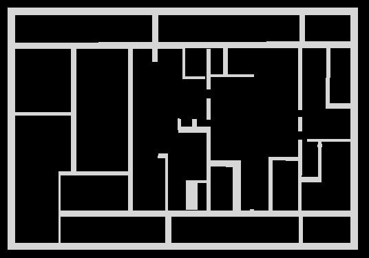
A rectangular road system have been designed which leads to proper distribution of the given area in 56 zones (sectors), which are again considered as individual units developed to self-sufficient units to handle the primary requirements of the residents. 3.1 Position of circular centers. A big circular center is placed at the intersection of the roads surrounding zones (sectors) and has been appropriately beautified by vegetation and architectural structures. 3.2 Combination of National Highway and rectangular street systems. The National highway appropriately connected to the city roads at various locations with two objectives viz., 1) To facilitate the movement of city traffic for out of city and 2) To keep bypassing traffic away from the city center. 3.3. Engineering features of streets. 4. Size of zones between streets. The size of zones vary in terms of area but is around 1 sq km for a major of them. Few zones are at extremes so as to maintain a proper network of roads but the area is considered for developing them. 5.. Buildings. The construction of all buildings start from the first floor so as to provide ample space at the ground level and to also act as a open shaded space for children to play and society clubs. A terrace garden with herbs and shrubs and high terrace boundary walls to make it secure for children. The walls contain slits which are replaced by fire resistant plywood so as to make them more earthquake resistant in case the city is earthquake prone. Metallic fire escapes mesh covering one face of the building is planned. The building contains water sprinklers and fire alarm to fight fire and closed circuit cameras for security and intercom
6. Theory of aspect In a city set out on the rectangular system almost every possible orientation in respect of individual blocks exists, and if the site be also undulating, choice of aspect in such a system can offer no difficulty, because of its multitudinous variety. So that whether industrial or other requirements demand the presence or absence of direct sunlight, those requirements are easily met. Buildings in which it is necessary to secure the maximum penetration of solar rays, so as to benefit by their heat in winter, and the minimum penetration so as to avoid the heat in summer, should so far as the geometry of solar shadows is concerned, have their long axes east and west and their windows on the north face of the building. Since, however, the temperature reaches a maximum after noon through the cumulative effects of the sun's heat rays, the axis should, theoretically, be rotated slightly, so as to turn a little to the north on the east side, therefore a little to the south on the west side. The amount of this rotation can be ascertained by taking account of the difference between the apparent noon and the times of maximum temperature; the differences between the noon and maximum temperatures, and the latitude of the place considered, the discussion extending over the changes for an entire year, so as to properly integrate the effects, and hence deduce their mean. The necessary rotation will, however, not greatly modify the E. - W. position for the axis. For buildings of a large size, and requiring spacious grounds, where aspect is important--as for example hospitals, sanatoria, etc.—we provided suitable blocks 7. The aesthetics of design. Green belts are planned by the side of the river and lake other than these there are gardens in every sector (a few remarkably big in size and with a theme which attract attention). There are discretely located monuments. All places of public attention carry architectural distinctive features and act as a monument in themselves. 8. Mathematical
calculations
The calculation of the population is based on the
income distribution given. 8.2 Educational Institutes
A university and a concept of joint college viz., a college catering to all the fields is considered and few other specialized institutes across the city. A primary and two secondary schools are located in every zone (sector). 8.3 Holy Places
The assumptions for the above are based on the real life experience from the surrounding, a guiding factor of number of people per holy place is taken which vary in accordance to the community. 8.4 Means of Transport The city is well connected via roads and the road density with respect to area is high so for intracity transport buses are used. Four (mostly) bus stops for every sector (zone) are designed so as to give flexibility to the buses in deciding there routes and changing them according to the flow of the population. The bus stops are approximately located at the physical center of the road juxtaposed with the sector. The buses are not allowed to enter the sectors, next to the bus stops are auto rickshaw, taxi stands. A Intercity (state) Bus Stand and a Airport is also provided. The Airport is located at the end of the city so as to avoid any limitations in locating skyscrapers in the city. The rail network is connected via two stations on either side of the river. 8.5 Law and Order As far as law enforcing units are concerned each sector has one police station. There is one Police head quarters and a central jail and a court. 8.6 Water management
To compensate the deficiency of water 11 tube per sector are planned. 9. Hygienic elements of design. The whole drainage system runs vis a vis to the roads and ends into the sewerage plants (one for four sectors) after proper treatment a sufficient portion is directed towards the agricultural lands (irrigational purposes), parks and fountains so that it could be utilized. There is a facility also to dispose the water in the river and lake if environmental limitations permit. There is a health office located one every sector which works under the direction from the bigger hospitals (4) and the municipal offices to develop a hygienic environment. | ||||||||||||||||||||||||||||||||||||||||||||||||||||||||||||||||||||||||||||||||||||||||||||||||||||||||||||||||||||||||||||||||||||||||||||||||||||||||||||||||||||||||||||||||||||||||||||||||||||||||||||||||||||||||||||||||||||||||||||||||||||||||||||||||||||||||||||||||||||||||||||||||||||||||||||||||||||||||||||||||||||||||||||||||||||||||||||||||||||||||||||||||||||||||||||||||||||||||||||||||||||||||||||||||||||||||||||||||||||||||||||||||||||||||||||||||||