 |
DAY 2 |
| 0500 Wake-up call. Prepare breakfast |
| 0600 Breakfast |
| 0630 Trek towards summit |
| 0650 ETA summit |
| 0715 Start trek towards base camp |
| 0735 Break camp |
| 0830 Start dexcent |
| 1030 ETA jump-off point |
| 1100 ETA Ternate. Lunch |
| 1430 ETA Manila |
DAY 1 |
| 1200 Assembly time at DIWA Head Office |
| 1300 ETD for Ternate, Cavite |
| 1530 ETA 'Magnetic Field' along Ternate hi-way. Start trek |
| 1600 ETA first Nipa hut. Registration. Last water source |
| 1800 ETA base camp. Pitch tent. Sight seeing |
| 2000 Dinner. Socials |
| 2200 Light's out. |
| Site created and maintained by richard
hidalgo For comments and suggestions, please e-mail us at [email protected] All rights reserved @ 2003. Buhawi Mountaineering Club |
| powered by: |
| Best viewed using 1024 x 768 screen resolution |
 |
| ITINERARY: |
| GETTING THERE: |
 |


| GENERAL INFORMATION: |
To get there, catch a bus bound for Maragondon or Ternate Cavite at Lawton or Vito Cruz. Saulog bus line is one bus company who plies the route. Then at Maragondon Cavite, hire a jeep that will take you to the jump-off area. From the jump-off or trailhead, a 2-hour hike will take you to a base camp passing by open fields, farms and grazing lands. Base camp is actually established anywhere or any open fields within the base of the mountain. Set-up camp here. A 20-minute hike to the summit is usually done without the packs. You can actually camp on the summit though it can accommodate only few tents and winds at the summit are usually strong which will continually pound your tents. From base camp to the summit, the climb is very steep but with ample bamboo to hold on.
(last update March 13,
2006) |
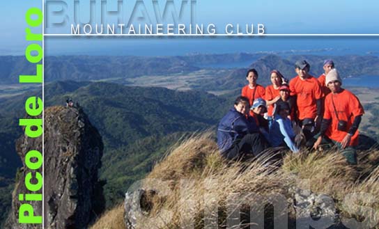
PICO DE LORO is located 85 kilometers southwest of Manila. It is bounded by the island of Corregidor and the Caraballo Mountains in the north, Nasugbu Batangas in the south, Maragondon on the east and the South China Sea on the west. With the height of 664 meters above sea level, it is considered the highest mountain in the generally flat Cavite province. Pico de Loro is the highest point on a series of rolling hills and mountains within the boundary of Cavite and Batangas. Though not really that high, the view from the summit is awesome, facing the tranquil seas on the north-eastern side particularly the Manila Bay area giving you a good vantage point to watch the ships passing by while the entire Batangas and Cavite on the south-eastern side will give you a glimpse of the south-eastern mountains like Batulao and Talamitam. Pico de Loro has a majestic view when seen near the base camp wherein it resembles a mighty rock-face with exotic flora along the sides resembling the North American rocky mountains, though on a smaller scale.
|