|
Satellite
photos of the region
Geographical co-ordinates of the reserve:
34º 28' South, 58º 30' West
Technical data about the satellite photos:
Images taken by Landsat satellite
Approx. date: 1990 (+ - 3 years)
Pixel resolution: 28,5m
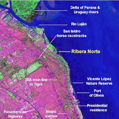
Photo 1: Northern suburbs of Buenos Aires - Olivos to
San Fernando
You can see from the photo that in 1990 (approx.)
the area covered by the image was almost completely developed. Even the
larger green patches are not natural landscapes but carefully tended grounds
(San Isidro racecourse, President's residence in Olivos). Of great importance
is the delta of the Parana - Uruguay rivers that just shows in the northern
corner of the image, and which probably supplies much of the fauna that
turns up in Ribera Norte. Other than this, hardly any places remain
where wildlife can find some sort of a home. In fact Ribera Norte is so
small that it is hardly visible at all. Also, since this image was taken
most of the natural areas visible along the narrow coastal strip have
since been developed, causing them to be lost forever as possible nature
refuges. Fortunately at least, in the year 2000 the Vicente Lopez Nature
Reserve was created. Even though it is very small it surely provides a
stepping stone for birds and other animals that need to move along the
coast. What was once a corridor for wildlife is today completely developed
riverfront.
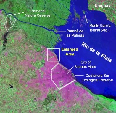
Photo 2: Greater Buenos Aires and surrounding area
The image below shows an expanded view of Photo
1. What seemed above to be a large borough where cement reigns supreme,
is in fact but a small part of a hugely expanded and developed city. It
is worth while pointing out that even at this scale we can quite clearly
note the much larger Costanera Sur Ecological Reserve in Buenos Aires
city (370 ha). Some of the animals of Ribera Norte and Costanera Sur must
surely "commute" between these two places. Of greater importance
still is the Otamendi nature reserve, spanning 3,000 ha of native
grassland and swamps. Its approximate outline is marked in the upper left
corner of the image.
¿Looking
for other satellite images?
Alternative 1: Landsat.org
Instructions: click on "Classic cearch tool".
This opens another page with a world map. Each dot represents the centre
of a satellite image. Clicking on it will open a new page with a list
of available sites (if any) generally taken on different dates. Selecting
one opens a new page with the image. Since these images are to showcase
products available for sale, they are not very high resolution, but are
still of great interest. You can also navigate to the 4 "neighbouring"
images.
Alternative 2: (This link is currently broken)
Navigate
the world from space with the LandSat images - (except
Afghanistan & Pakistan) by going to this
NASA website (http://zulu.ssc.nasa.gov/mrsid/mrsid.pl)
(Basic instructions: once you've selected the map you want to see, click
on "Select Image" and then click again on the grid or map. This
will open ANOTHER window of your browser which shows the image. Clicking
on the image or the zoom selector will bring up enlarged versions from
1 to 100% that will be centred on the spot you clicked on.
|