|
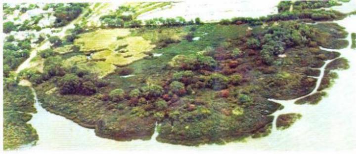
Ribera Norte seen from the air
Many thanks to Lucio
Contigiani for letting me use his unique pictures (numbers 1 to 4).
Geographical
location of the reserve: 34º 28' South,
58º 30' West
 |
Photo 1
Dated
1984
Approx direction: northwest
Click to see enlarged image (41K).
|
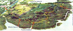 |
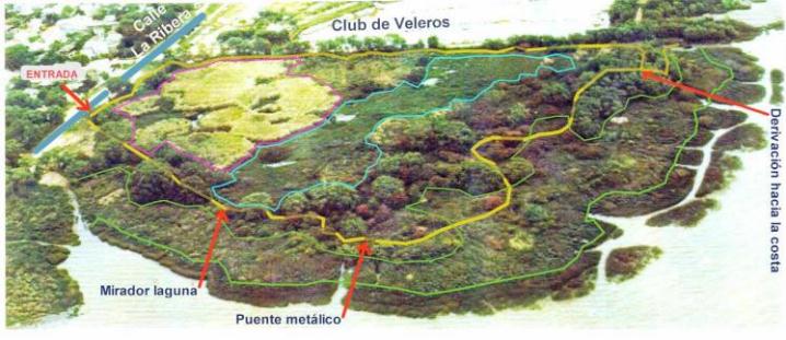
Photo 2
Same photo in which the trail and various habitats have been
marked out. See color key below.
Click to enlarge (51K).
|
Color Key:
- Yellow: the 400m-long trail.
The area in white is open water: Río de la Plata (ie, River Plate),
lagoons and neighbouring sailing club
- Area outlined in sky blue is the "lagoon" (sometimes, as here,
much invaded by native floating vegetation)
- Area outlined in pink is the main stand of rushes (now partly invaded
by exotic Yellow Iris)
- The area between the coast and the first green line are coastal reeds.
- The area between the first and second green line is coastal bushland
(now invaded by exotic privet)
- The area behind the second green line is riparian forest, where most
of the ceibo trees grow and includes the willow forest.
- The street outside is marked in blue.
Note: The trees that have a reddish tinge are Ceibo trees
in full bloom. The larger tres are mostly willows.
"Milestones":
Red arrows mark specific points at which the trail may sometimes be closed
to the public. From left to right: 1) the entrance to the reserve, 2)
at the lagoon, 3) at the metal bridge, and 4) at the bifurcation about
1/2 way around, forcing the return to be back along the same path. These
closures may be required during or after rain (as the trail becomes muddy),
peak tidal flooding (causing much of the reserve to be completely covered
by water and leaving behind large ammounts of trash, which has then to
be collected), or after serious storms that can cause much damage (fallen
trees, land shifts, trail "wipeout", huge piles of rubbish such
as tree branches, reeds and plastic bottles, and so on). Recovery and
cleanup can be slow, but eventually happens! During all 2003-2004 the
return leg running next to the yacht club premises was closed as this
section has sunk and the trail is always soggy. Plans are under way to
build up this section of the trail.
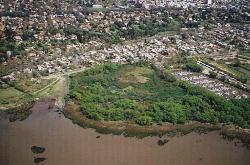 |
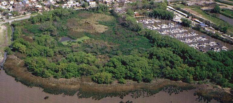
Photo 3
Dated February 2003. Shows the reserve and the urban surroundings
Direction:
looking approx. to the West
Click to see enlarged image (109K).
|
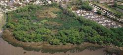 |
Photo 4
Detail of previous photo
Note trees (mainly
the willows)
are much taller
than in 1984 photo
Click to see
enlarged image (64K).
|
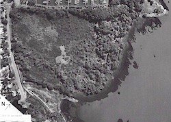 |
Photo 5
Black and white overhead photo
Dated: 29th April 2003
Scale: Each division of the ruler in the bottom
lefthand corner is 20 meters.
Click
to see enlarged image (135K).
|
|