ADMIRALITY LIST OF RADIO SIGNALS:
8 VOLUMES PUBLISHED ANNUALLY EXCEPT FOR VOLUME 4 WHICH IS PUBLISHED EVERY 18 MONTHS.CORRECTIONS FOR THESE ARE ISSUED EVERY WEEK UNDER SECTION 6 OF THE WEEKLY NOTICES TO MARINERS.
ALRS. VOLUME 1: NP - 281;COAST RADIO STATION, PUBLIC CORRESPONDENCE.
INCLUDES ALL FREQUENCIES AND CLASSES OF EMMISIONS.INFORMATION ABOUT MEDICAL ADVICE BY RADIO - INMARSAT MARITIME SATELLITE SERVICE.GMDSS.SHIP REPORTING SYSTEM.PIRACY REPORTS.REGULATIONS FOR USE OF RADIO IN TERMINAL WATERS.BREIF EXTRACT OF RADIO REGULATIONS TOGETHER WITH ASSOSCIATED DIAGRAMS.
PART 1: EUROPE, AFRICA AND ASIA (EXCLUDE PHILLIPINES AND INDONESIA).
PART 2: PHILLIPINES, INDONESIA, AMERICA, AUSTRALIA, GREENLAND AND ICELAND.
ALRS. VOLUME 2: NP - 282; RADIO NAVIGATIONAL AIDS
INCLUDES RADIO DIRECTION FINDING.RADAR BEACONS.RADIO TIME SIGNALS.ELECTRONIC POSITION FIXING SYSTEMS.
ALRS. VOLUME 3: NP - 283;
RADIO WEATHER SERVICES AND NAV WARNINGS TOGETHER WITH OTHER M.S.I. BROADCASTS. (MARINE SAFETY INFORMATION).
PART 1: EUROPE, AFRICA AND ASIA (EXCLUDE PHILLIPINES AND INDONESIA).
PART 2: PHILLIPINES, INDONESIA, AMERICA, AUSTRALIA, GREENLAND AND ICELAND.
ALRS VOLUME 4: NP 284 - LIST OF METEOROLOGICAL OBSERVATION STATIONS.
THIS VOLUME IS ALSO AVAILABLE ON FLOPPY.
ALRS VOLUME 5: NP - 285; GMDSS.
ALRS VOLUME 6: NP - 286;PILOT SERVICES AND PORT OPERATIONS.
INCLUDES ALL THE MARITIME RADIO PROCEDURES ESSENTIAL TO ASSIST VESSELS REQUIRING PILOTS AND/OR ENTERING PORTS.
PART 1: EUROPE AND MEDITERRANEAN.
PART 2: AFRICA, ASIA, AUSTRALIA, AMERICA, GREENLAND AND ICELAND.
ALRS VOLUME 7: NP - 287; VESSEL TRAFFIC SERVICES AND REPORTING SYSTEMS.
IT CONTAINS ALL THE INFORMATION ON THE MANY LOCAL, NATIONAL AND INTERNATIONAL VESSEL TRAFFIC SERVICES. (V.T.S.)
PART 1: EUROPE AND MEDITERRANEAN.
PART 2: AFRICA, ASIA, AUSTRALIA, AMERICA, GREENLAND AND ICELAND.
ALRS VOLUME 8: NP - 288; SATELLITE NAVIGATION SYSTEMS.
CONTAINS ALL THE INFORMATION ON ALL ASPECTS OF SATELLITE NAVIGATION SYSTEMS INCLUDING DETAILED EXPLAINATION AND ADVISE ON VARIOUS POSITION ERROR SOURCES.
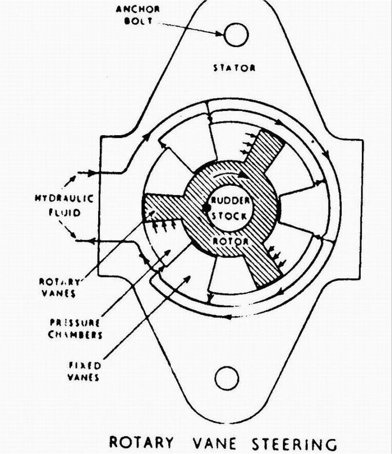
ROTARY VANE STEERING GEAR:
�The rotary vane type of steering gear system is a more recent development of the hydraulic steering gear.
�It consists of a rotor, which is a taper fit on the rudderstock and keyed to it, and a stator of a larger internal diameter than the outside diameter of the rotor to form an annular space between them.
�The stator being firmly fixed to the ships structure to prevent its rotating.
�The rotor has equidistantly spaced outwardly projecting radial vanes, and the stator has similar vanes projecting inwards, the spaces between the vanes form segmental pressure chambers for the high-pressure hydraulic oil supplied from the variable delivery pumps.
�Oil sealing between the ends of the vanes and their opposite working surface is effected by rubber-backed steel strips in grooves in the vanes.
�The pressure chambers between the rotor and the stator vanes are divided into two sets so that when the oil at a high pressure is supplied to one set and drawn form the other, the rotor will be forced to rotate in one direction turning the rudder stock with it.
�By reversing the oil flow the rotor and the rudderstock will rotate in the opposite direction.
�Allowing for the thickness of the vanes, a unit of three rotor vanes and three stator vanes will permit a rudder movement of 35 degs to extreme port or stbd from mid position.
�A total angle of 70 degs. Is achieved and the vanes also act as rudder stops.
�Relief valves and by-pass valves are incorporated in the oil system to absorb rudder shocks.
�Compared to the four ram steering gear, the cost of the rotary vane type to produce the same torque on the rudder stock is generally less, it is lighter in weight, takes up less space and is easier to maintain.
E P I R B: EMERGENCY POSITION INDICATING RADIO BEACON
Basically there are three types of epirbs for general use commonly found on ships:
1)COSPAS-SARSAT EPIRB.
2)INMARSAT-E EPIRB.
3)VHF DSC EPIRB (CH 70 DSC).
1)COSPAS-SARSAT EPIRB:The system uses several satellites at a low earth orbit of 850-1000 kms,each of the satellites making a complete orbit of the earth in about 100 minutes.the satellites are designed to receive on 121.5 and 406.025 MHz
it employs dopler shift principles using the relative motion between the satellite and an activated beacon to calculate the location of the Beacon.Once the beacon signal has been received it is relayed by the satelli8te to a specialised ground station called the Local User Terminal(LUT),And then to M.C.C. And M.R.C.C.
MODES OF OPERATION: There are two modes of detection of the beacon by the system.
1)REAL TIME MODE: In this type of mode a repeater on board the satellite relays the epirb signal directly to the ground where it is to be received and processed by the L.U.T.For this mode the LUT and the EPIRB have to be in the footprint of the satellite.
2)GLOBAL COVERAGE MODE:The satellite stores the signals activated from the 406 MHz EPIRB,so the satellites path/footprint brings it in view of a LUT.Information including beacon I.D. frequency of detection and time of detection is continuously relayed down to the L.U.T. which after computing the position of the beacon shall relay the same to the RCC/MRCC.This mode is only for the 406 MHz EPIRB.
Every 406 MHz EPIRB has a unique identity code which is a part of the signal,this code could be a call-sign,serial number or a MMSI number.This code is programmed by the supplier before it is installed on the vessel.It is imperative that the EPIRB is registered with the relevant authorities in the flag state so that information can be readily available to the authorities during a crisis.
SPECIFICATIONS:
1)The EPIRB shall be placed in an easily accessible position like the bridge-wing or the compass deck.
2)Be capable of manual release and also be capable of being carried to the survival craft by a single person.
3)Be capable of being floating free from a sinking vessel if it is fitted with a H.R.U.
4)Be capable of being activated manually.
EPIRB OPERATION.
It is a small self containded battery operated radio trasmiter (operation eye 48 hrs)which is both water fight & buoyant operations differ between model.However all beacons operate between the following:
OFF/SAFE:The beacon is switched off& will not transmit.
ARMED /AUTO:The beacon will auto matically switch on when it is to be released from the float free bracket (armed type) or will activate when itr gets in contact with contact with water as there are two mettalic contacts on the bottom(auto).
ON :The beacon will automatically switch on and transmit (manual mode).
TEST:Activates a built in test routine.
The purpose of epirb to determine the position or the survivors/ distress vessel during SAR operations and as a secondary means of altering.It indicates that one or more persons are in distress may no longer be on board a ship or aircraft and that receiving facilities may not be avaiiable.
2)INMARSAT 'E'EPIRB OR 'L'BAND EPIRB:
It utilises the geo stationary satellite system.The transmission is made alternately im frequency ranges from 1644.3 MHz & 1644.5 MHz & 1645.500-1646.5 MHz in order to be received from both the first & the following generations of inmarsat satellites.
Upon activation the epirb trasmits a distress altert containing the ships station identity, position information either GPS or manual & additional information (nature of distress).They cannot be used in area A4.It has a inbuilt GPS.
3)VHF DSC EPIRB:
Is operates on Channel 70 & can only be used in Area A1.
All VHF DSC EPIRBS will have an inbuilt SART so that it can reveal its position to the vessels in the area where the EPIRB is activated.When the VHF DSC EPIRB is activated on the DSC it will only show nature of distress as undesignated and further "EPIRB emission shall appear"
Copyright � 2000-2005 Rautelas. All rights reserved.