Title
of the
Dissertation: |
“Estudio de Pre-factibilidad
del Sistema de Riego para la Comunidad de Sigsihuaico en la provincia del
Cañar”. |
Title
in
English: |
Pre-feasibility
study of the Irrigation System for the community of Sigsihuaico at the province
of Cañar |
Original
extent: |
209
pp. (2 volumes) + many additional appendixes and cartographic and design
maps. |
University
/
Faculty: |
Universidad de
Cuenca / Facultad de Ingeniería,
Ecuador. |
| Download This page in PDF format |
Ecuador
with a surface of about 283000 km2 is considered to be one of
the smallest countries of South America. Nevertheless, in such a small territory,
it hosts a great biodiversity in terms of flora and fauna as well as ethnic
variety (about 21 ethnic groups). The current Dissertation constitutes a
multidisciplinary assessment on the feasibility of an irrigation system for
a rural (indigenous) community, Sigsihuaico, located on one of the most beautiful
but at the same time poorest Andean regions of the country (i.e. the province
of Cañar).
The dissertation condenses in 20 chapters results from both applied
engineering activities as well as research approaches. In this context, the
dissertation focuses mainly in areas related to Civil Engineering, Water
Resources Engineering, Agricultural Engineering (c.f. Chapters 7, 11 and
17), Applied Economics (c.f. Chapters 15, 16 and 17) as well as Social aspects
(c.f. Chapters 5 and 17). The practical work (field and office) and the editing
of the dissertation was carried out in a period of 20 months, during the
last study year of the six-year Civil Engineering Programme of the Faculty
of Engineering of the University of Cuenca as well as after the completion
of this study Programme.
In this dissertation, the term “community” has a monolithic
connotation referring to both the study site and the indigenous group settled
down on it. The dissertation starts with a
Definition of the problem (c.f.
Chapter 1) followed by
Technical, Economical and Social
Justifications of the assessment (c.f.
Chapter 2) and the definition
of the General and Specific Objectives
of the assessment (c.f. Chapter 3). A review of the state of the art (within a national
context) as well as of the available information relevant to the study area
is summarised in Chapter
4.
Chapter 5 deals with
Preliminary Studies that addresses
topics such as:
(i)
The
description of the indigenous group, its organisation, its typical familiar
composition, its traditional way of distributing rights to its members on
the use of land and water, the main cultural and religious aspects ruling
in the study site, etc.;
(ii)
a
brief description of the study site, taking into account aspects such as
current land use, cropping planning, production and market possibilities,
crop market prices, potential land use and expected production, current water
sources and inventory of water uses, etc.; and
(iii)
a list of recommended agreements between
the community and governmental and non-governmental organisations, aiming
the optimisation of the assistance to the Community of
Sigsihuaico.
Chapter
6
gives a detailed description of the
Topography and Geomorphology of
the study area (Fig. 1). The topographical surveying of the study area was
based on the application of altimetry and planimetry methods using accurate
optical theodolites and levels and demanded a very intensive field campaign,
data processing for interpolation of the topographical surface by using a
combination of both manual as well as computer based methods (i.e. through
the use of Geographical Information Systems, GIS) and the drawing (by hand)
of suitable cartographic and design plans. As depicted in Fig. 1, the northern
and eastern limit of the study is the river Cañar. The study area
has an estimated surface of about 212.16 ha from which 160.89 ha are cultivated
and 51.27 are covered by forest. The chapter discusses aspects related to
the limits of the area suitable for irrigation, land use in general, the
agricultural use of the land in particular, the planimetry of land property,
study of land slopes, inventory and location of existing communication ways,
inventory and location of electricity infrastructure, location of data gathering
stations, inventory and location of existing irrigation and drainage
infrastructure, study of potential interferences among these existing
infrastructures, and location of permanent wetland regions. The chapter includes
a series of technical appendixes on the topographical and geo-morphological
analyses.
The
existing infrastructure includes 4 earthen reservoirs of different capacity
that were built up in the past by the Ecuadorian Ministry of Civil Constructions
(MOP), attending a request from the Community in an attempt to store rainfall
as well as a limited irrigation discharge allocated in the past to the Community
by the Ecuadorian Institute of Water Resources (INHERI) an that is conveyed
by the Quinuales canal connected to one of the reservoirs (c.f. Fig. 1).
The reservoirs are labelled in Fig. 1 as R1, R2, R3 and R4
respectively.
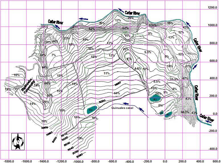
Figure
1. Map of the study area defining the topography, mean slope regions,
communication infrastructure and location of the water reservoir facilities.
The coordinates’ system is local and referred to the topographical surveying
landmark placed on reservoir R1.
Chapter
7
deals with the Edafology-Studies.
In this context, physical, hydro-physical and chemical properties of the
main soil units that exist in the study area are reported in this chapter.
Furthermore, other aspects such as the critical soil saturation depth, the
potential for soil salinisation and the relationship natural fertility/necessity
for nutrient application are discussed. The chapter ends up with a series
of appendixes on the physical tests and prospections and chemical
analyses.
Chapter
8
reports the Climatologic Studies.
Variables such as precipitation, temperature, wind intensity and direction,
relative humidity and vapour pressure were included in the study, which involved
several steps such as data gathering, data processing and completion of data
gaps. Prior analyses were done with the intention of defining important
parameters for water balance such as potential crop evapotranspiration
(ETc), which was estimated
with the Food and Agriculture Organisation (FAO) Penman-method 24 (FAO-24;
Doorenbos and Pruitt, 1977; Allen et al., 1998; Vázquez and Feyen,
2004). Climatologic data from neighbouring stations were used in the study.
However, a local station was installed and operated in the study area to
collect pan evaporation data throughout the duration of the overall studies
in an attempt to cross check on the congruence of the ETc
estimates.
The main results of the
Hydro-geological Studies are reported
in Chapter 9. This chapter addresses
aspects such as the natural regime of the water table in the study area,
the chemical characteristics of the groundwater and its potential harmness
on the construction materials of both the existing and the proposed
infrastructures and the analysis of the feasibility of using groundwater
for irrigation purposes.
In Chapter 10 the proportion of the study site that is considered
as technically Suitable for
Irrigation is defined on the basis of topographic and geomorphologic
considerations. In Chapter 11
a Planning of the crops for the projected irrigation system is
presented. This planning was carried out from an ecological perspective and
after conducting field surveying and sounded polls about the cropping habits
of the community and vicinity market requirements. In this context, the chapter
includes a description of the period of development of the considered crops,
average crop water requirements as a function of the different crop development
periods and the recommended temperature range for a suitable crop
production.
In Chapter 12 a detailed analysis of the variables affecting the
Irrigation Planning is depicted.
With this purpose in mind, a thorough water balance was carried out to define
the irrigation schedules by considering parameters such as crop
evapotranspiration, precipitation and other irrigation parameters based on
the hydro-physical properties of the soil units, such as Field Capacity (FC),
Welting Point (WP), Total Available Water (TAW) and the Readily Available
Water (RAW).
The Hydrological Studies are described in
Chapter 13. These include:
(i)
The definition of the hydrological
network of interest for the projected irrigation system;
(ii)
the determination of the general
mass curve for the Cañar River that is the (potential) principal water
source for the irrigation system (Fig. 1). Average daily discharges were
used. This curve gives information on the percentage of days with water shortage
as a function of discharge and was prepared after a frequency analysis. The
design-discharge for the projected irrigation system was estimated previously
as about 0.173 m3s-1, whilst the mass curve analysis
revealed a 70 % confidence discharge for the Cañar River of about
1.66 m3s-1.
(iii)
a
frequency analysis on maximum monthly discharges for defining maximum design
discharges (assuming that successive monthly data are uncorrelated). A 240-year
return period was considered. The corresponding estimated discharge is 49.6
m3s-1.
(iv)
analysis of the water availability
for the different water conveyance alternatives considered in the study,
namely, driven by gravity, by means of a combined gravity-pumping system,
by means of a pumping station;
(v)
determination of the characteristic
discharges of the Cañar river and main
tributaries;
(vi)
analysis of the load and physical
characteristics of the suspended sediments transported by the water sources
(i.e. for designing sedimentation structures);
(vii)
physical
and chemical analyses of the water available for
irrigation;
(viii)
analysis
of the range of variation of the water levels in the zone proposed for water
intake in the Cañar River, for which limnimetric stations were installed
and monitored throughout the duration of the studies.
The Formulation of water
intake and distribution Alternatives
is detailed in Chapter 14.
The chapter starts with a preliminary definition of three potential alternatives
(A) upstream water intake to 9.6 Km from the irrigation area and posterior
water conveyance by gravity up to the highest reservoir; (B) upstream water
intake to 6.4 Km from the irrigation area, a subsequent water conveyance
by gravity up to a lower reservoir and a posterior pumping of the water until
reaching the highest reservoir; and (C) water intake from the closest point
in the Cañar river and subsequent pumping of the water for reaching
the highest reservoir. On the basis of the technical-economic analysis reported
in Chapters 15 and 16, option (C) was chosen and its infrastructural
components, such as the water derivation infrastructure, the pumping station
and the pipe line for the upwards conveyance of water, were designed as described
in the rest of Chapter 14. The pumping station was designed considering
irrigation water distribution by both rotation as well as
demand.
Chapter 17 presents a
Study of the Agro-economic
Alternatives for the proposed irrigation system. The chapter covers key
aspects such as the expected costs and benefits and the estimated period
of adaptation of the community to the advised agricultural practices. The
chapter includes several appendixes that illustrate the economical
analyses.
The dissertation ends up with a selection of (i) the water intake
and conveyance systems; (ii) the water distribution system; and (iii) the
agricultural management approach that is included in
Chapter 18.
Chapter 19 condenses some
recommendations directed to the future potential users of the irrigation
system (i.e. the indigenous community) and the governmental and non-governmental
organisations with which the community has established contacts in the past.
The recommendations are tending to achieve the education of the community
in terms of soil and water conservation, suitable agricultural practices
for a sustainable ecological management of the system, the maintenance of
the installed meteorological station and the installation of (a) newer station(s)
in the study area, etc.
Finally,
all the Cartography that was produced
throughout this study is making up
Chapter 20. Although, GIS software
such as GRASS, IDRISI and SURFER were used in the scope of the study, most
of the cartography was drawn by hand owing to the lack of a suitable printing
device. The cartography topics are: land ownership, topography, geomorphology,
soil textures, current land use, potential land use, irrigation system layout,
water distribution network, water intake infrastructure and vertical profile
of the pipe line.
This
assessment constitutes a pioneering approach in the southern Ecuadorian region
to planning and designing irrigation systems in mountainous regions following
a sounded technical and scientific multi-disciplinary background. As such,
this pioneering assessment was the foundation for the latter establishment
of what is now known as the Programme for Land and Water Management, an Institute
annexed to the Faculty of Engineering of the University of
Cuenca.
Allen GR, Pereira LS, Raes D, Martin S. Crop evapotranspiration-Guidelines
for computing crop water requirements, FAO Irrigation and Drainage Paper
56, Rome, 1998.
Doorenbos J, Pruitt WO. Crop water requirements, FAO Irrigation and
Drainage Paper 24, Rome, 1977.
Vázquez RF, Feyen J. Potential Evapotranspiration for the
distributed modelling of Belgian basins. J. Irrig. Drain. Eng. 2004;
130(1):
1-8.