DETECTION, BY THE TOVS, OF SOME CASES OF INFLUENCE OF THE ITCZ
OVER THE NORTHEAST REGION OF BRAZIL IN ITS RAINY SEASON
Raul Fritz Bechtel Teixeira
Fundação Cearense de Meteorologia
e Recursos Hídricos - FUNCEME
Fortaleza, Brasil
FUNCEME (Foundation for Meteorology and Water Resources of Ceará State, a brazilian governmental institution without lucrative ends) began the processing of TOVS TIP (TIROS Information Processor) data in 1993 using the ITPP-4 software (International TOVS Processing Package, version 4) supplied by the CIMSS (Cooperative Institute for Meteorological Satellite Studies), University of Wisconsin-Madison, USA (Achtor 1990).
FUNCEME has developed a friendly graphical interface (in XClasses) to the ITPP in order to facilitate the execution of the program. In this interface several practical "windows" permit to chose the TIP data and the processing parameters of the ITPP.
Some display facilities of ITPP products has been added to the software by FUNCEME. One of these comprises the production of ITPP meteorological fields with the aid of the software GrADS (Grid Analysis and Display System), developed by University of Maryland, USA.
The air temperature and moisture derived from ITPP-4 at 1000 hPa were compared in the past with ground stations data, for some points of the Northeast Region of Brazil (regionally known as NEB) where the Ceará State is located.
Some ITPP-4 temperature and moisture retrievals were compared with simultaneous and nearly simultaneous radiosonde profiles performed at Fortaleza and other cities of the North Region of Brazil and NEB and for different forms of ITPP processing: (i) either low or high resolution of topography; (ii) either "first guess" of the vertical structure by climatology or regression coefficients; (iii) either using ensembles of fields of view, for each retrieval, with 3 scan spots across the satellite track by 3 scan spots along the track or using all the spots, and (iv) the use of known surface data to "anchor" the satellite profiles. In fact, all this has been made for the local validation of the model. In those cases, the retrievals were obtained via the option: msu+hirs (stratospheric) channels if full-hirs fails.
The results obtained using the ITPP-4 has indicated better temperature retrievals than moisture retrievals. In general, major discrepancies of the air temperatures were encountered near the surface; either 500 hPa or 400 hPa and at 100 hPa (where the latter was found near the tropopause).
The regression first guess seemed better than the climatological guess, as well as the high resolution of topography in comparison with the low resolution.
Sometimes, the anchoring of the profiles resulted in profiles more closed to the radiosonde soundings. Thus, this technique really could be used to aid the retrieval processing.
Despite some retrievals based on 3x3 spots method are not so good, the method is still preferable to the other which uses all the spots (a large amount of good and bad retrieved profiles). The 3x3 method has a smaller time processing and gives practically the same results as the other.
The last release of the ITPP, the fifth version (Achtor 1995), was installed at FUNCEME in 1995.
Some qualitative comparisons between relative humidity fields of the ITPP-4 and ITPP-5.0 at 1000 hPa, of parts of Brazil (NEB included), with the corresponding relative humidity analysis fields at surface given by the MRF (Medium Range Forecast) model from the NMC (National Meteorological Center), USA, showed that ITPP-5.0 agreed better with the MRF fields than the ITTP-4 mainly whenever the TIGR french database of profiles were used with the regression first guess. It was observed that the regression P12S mode didn't show certain humidity gradients viewed in the MRF fields.
Other temperature and moisture retrievals of the ITPP-4 and ITPP-5.0 were compared with simultaneous and nearly simultaneous radiosonde profiles performed at Fortaleza and other cities of the NEB to verify the divulged scientific ITPP-5.0 enhancements, which would improve temperature and even moisture retrievals. Several forms (those beforehand mentioned) of ITPP processing were tested. In any case, the ITPP-5.0 produced better temperature profiles (even at the surface and without be at anchor) than ITPP-4 but the moisture apparently didn't exhibit an appreciable and systematic improvement. In general, the best results were reached when it was used the regression guess together the TIGR data.
Some few tests were made with numerical global model outputs (from the Center for Weather Forecasts and Climate Studies - CPTEC - of the National Institute for Space Research - INPE, Brazil) as first guess of the ITPP-5.0. However, the first results didn't show significant improvements on the retrievals but the tests need to be continued.
Moreover, FUNCEME didn't use yet the information of AVHRR (Advanced Very High Resolution Radiometer), i.e. the collocated HIRS/2 and AVHRR data, in the ITPP-5.0 particularly in cloud clearing and surface skin temperature determination in the thermodynamic retrieval process.
These, therefore, are the main research activities related to TOVS already developed at FUNCEME.
Through those researches, TOVS data derived from NOAA-14 satellite atmospheric soundings are currently being processed at FUNCEME by means of ITPP-5.0 software using, in an operational way, the "regression guess and tigr database" basic mode as an auxiliary source of meteorological information to the weather forecast for Ceará and the other States of the NEB. Normally, two overpasses of the NOAA satellite are processed daily (i.e. in the morning and in the afternoon) and they are placed in the homepage of FUNCEME (http://www.funceme.br) as charts of meteorological fields (relative humidity at 1000 hPa, total precipitable water vapor, 500 hPa lifted index, k instability index, air temperature at 1000 hPa and total outgoing longwave radiation) to accomplish this goal.
The vertical sounder TOVS on board the NOAA-14 satellite presents some limitations which will be surmounted by the new satellite NOAA-15 put in orbit last year. This satellite carries the AMSU (Advanced Microwave Sounding Unit), which is a sensor for providing better profiles of temperature and moisture, even with cloud coverage in the ATOVS (Advanced TOVS) era (Goodrum 1998).
In this work, we show that, even in the ATOVS era, some ITPP-5.0 products derived from the NOAA-14 TOVS soundings may be used to aid the weather forecast over areas in the Southern Hemisphere and near the equator as for example the NEB, which is almost entirely not provided with radiosonde data. However, we are aware that this procedure may result in data of inferior quality.
These ITPP-5.0 products were used to predict (although qualitatively!) some cases (the first two!) of influence (on the precipitation) of the Intertropical Convergence Zone (ITCZ) over the north of the NEB (specially the Ceará State) in the rainy season (February to May) of 1998. That was an attempt to verify if the ITPP-5.0 meteorological fields showed minimum atmospheric conditions (great moisture and great instability of the air), sufficient to the formation of clouds and consequently generate precipitation at the first actuations of the ITCZ over the north of the NEB. It is desirable to remember that the ITCZ is the main inducing system of precipitation over the north of the NEB. So, this work can be used to illustrate the current operational use of TOVS data (in the form of HRPT data, i.e. High Resolution Picture Transmission) received and processed at FUNCEME.
TOVS data from NOAA-14 satellite, displayed as relative humidity at 1000 hPa, total precipitable water vapor and 500 hPa lifted index ITPP-5.0 (regression/tigr) fields, were used during the first two incursions of the ITCZ in the north of the NEB during its rainy season of 1998 to verify if the prognostics of rain of the ITPP were correct according to the moisture and instability of the air fields.
Reports of observed rain (for Ceará) and daily meteorological analysis were used as a base of information to verify the qualitative prognostics of rain from the meteorological fields derived from the TOVS and using the ITPP-5.0 software.
By the end of January 1998, when the "Pre-Season Rain" of the north of the NEB was over, it was observed the actuation of an upper air cyclonic vortex with center at the east coast of the NEB allowing the generation of clouds and the occurrence of isolated areas of precipitation, mainly over the States of Maranhão (Ma), Piauí (Pi) and Ceará (Ce). It rained in several regions of Ceará (mainly at the coast and its adjacencies) due to the vortex and to some convective systems related to the vortex.
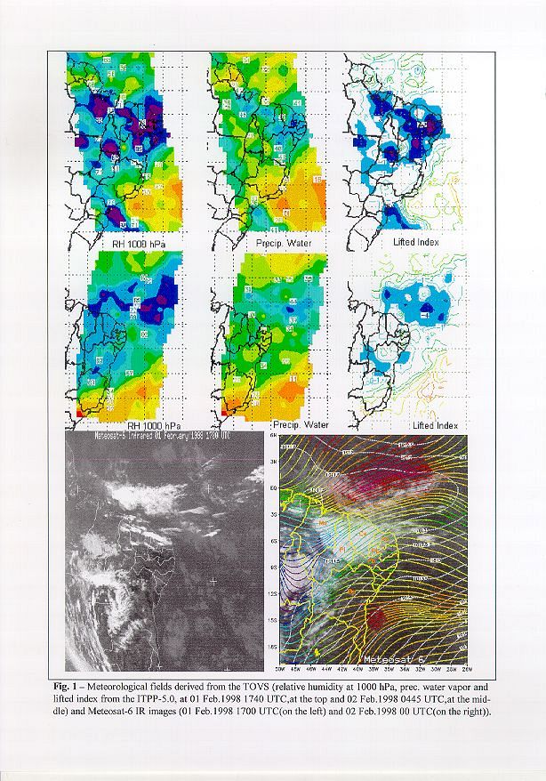
At the beginning of February which corresponds to the beginning of the rainy season of the north of the NEB, the sea surface temperature was 301.15 K along the coast of the NEB. There was wind convergence at surface near the State of Ceará and low pressures in this region so that it is occurred the positioning of a nebulosity band associated to the ITZC over the north of the NEB producing rain along the Ceará State (the reader should refer to the Fig.1, specifically at its right bottom corner, which is a Meteosat-6 infrared image, collected at 2nd February, 1998, at 0000 UTC which is 2100 local time of 1 st February, added with pressure lines at sea level and streamlines at 1000 hPa). This was, therefore, the first influence of the ITCZ over the north of the NEB in its rainy season.
Meteorological fields derived from the TOVS (TIP data obtained from an overpass of the NOAA-14 at 1st February, at 1740 UTC, and processed by the ITPP-5.0 software) are viewed in Fig.1 where the bluish and purple areas denote great moisture and great instability of the air. These fields showed moisture and instability of the air practically coincident with the field of clouds viewed in the Meteosat-6 image beforehand mentioned. The ITPP-5.0 fields have approximately anticipated the areas where clouds and some rain were generated. The Meteosat-6 infrared image (see Fig.1 at its left bottom corner), collected at 1st February, at 1700 UTC (close to the moment of the overpass of the NOAA-14) showed nebulosity near the coasts of Rio Grande do Norte (Rn), Ceará, Piauí and Maranhão, at the south of Maranhão and Piauí and at the west of Bahia (Ba). Seven hours later clouds were generated at Ceará, west of Rio Grande do Norte, Paraíba (Pb) and Pernambuco (Pe) and at Piauí and Maranhão according to the prognostics of the ITPP-5.0. Nevertheless, the ITPP-5.0 indicated greater nebulosity in the north of Bahia than it was observed. Moreover, the northwest of this State remained cloudy.
Fig.1 shows the next overpass of the NOAA-14 at 2 nd February, at 0445 UTC, with the fields of moisture and instability of the air concordant with the analysis beforehand mentioned (February 2, at 0000 UTC) and with the daily rain report over Ceará.
In Ceará, there is a popular belief which states that if it rains on 19 of March (close to autumm equinox in the Southern Hemisphere) the following raining days will be more regular (it is noteworthy that the rain is frequently badly distributed in space and time in the NEB).
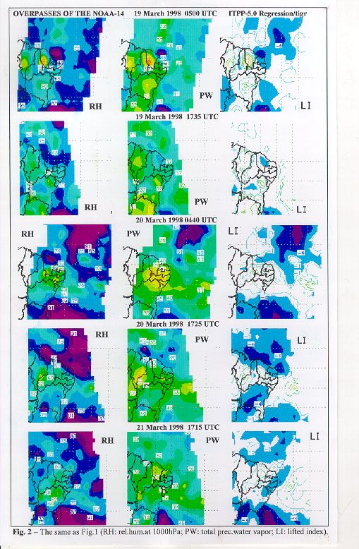
In 1998, in the epoch near the autumm equinox it was observed some rain in Ceará (a few milimeters at the coast) from the morning of March 17 to the morning of March 18. It was not observed much rain over Ceará until the morning of March 19. It rained a little more than the day before (mainly at the coast) until the morning of March 20. It rained over all Ceará and mainly over the coast until the morning of March 21. The rain over Ceará decreased in the next day and increased again (mainly at the coast) on March 23. A high level trough have produced low pressures over the north of the NEB so that a nebulosity band of the ITCZ have reached the State of Ceará producing rain over all the State notedly over its coast.
ITPP-5.0 fields of moisture and instability of the air derived from the NOAA-14 TOVS data (Fig.2 where the bluish and purple areas denote great moisture and great instability of the air) for the epoch near the autumm equinox were concordant with the daily rain reports over Ceará.
The ITPP-5.0 fields of the first hours of March 19 indicated light rains for the next morning over Ceará with exception, perhaps, of its northeast coast. The fields in the afternoon of March 19 and in the first hours of March 20 indicated rains for the morning of March 20 over Ceará mainly for the coast. The fields in the afternoon of March 20 showed possibility of rain for the next day over Ceará notedly at its coast. The fields in the afternoon of March 21 evidenced a possible reduction of the rains for the next day over Ceará. These predictions were confirmed by the rain reports for Ceará. Unfortunately the overpass of the NOAA-14 received at the beginning of March 22 reached only the east coast of the NEB and the overpass of the afternoon was lost. The overpass of the beginning of March 23 reached the east coast of the NEB so that it was not possible to make a prognostic for the morning of this date.
The ITPP-5.0 meteorological fields derived from the TOVS are being used with some success at FUNCEME as an auxiliary source of information for the wheater forecast for the Ceará State and NEB.
The ITPP-5.0 fields of moisture and instability of the air (the relative humidity at 850 hPa would be more suitable than at 1000 hPa and the k index could aid the lifted index used in this work) can be used, therefore, as a reasonable indicative of the potential of precipitation of an area. However, sometimes the generation of clouds and rain predicted by the ITPP-5.0 doesn't happen. The 500 hPa lifted index is a forecast index and a useful tool for the prediction of the latent instability of the air but, maybe, some meteorological mecanism can inhibit the atmospheric convection foreseen by the index. Moreover, the TOVS frequently has difficulties in doing atmospheric profiles under cloudy conditions.
Finally, FUNCEME also intends to use, very shortly, ATOVS to improve its wheater forecasts.
TOVS and ATOVS will still be used for several other ends as for example in the climatological study of the atmospheric moisture and of its transport on the Atlantic Ocean between NEB and the west of Africa (a research project to be established with ORSTOM and MÉTÉO-FRANCE, of France).
Achtor, T., H. Woolf and A. Schreiner, 1990. In User's Guide to the International TOVS Processing Package. Version 4.0 . Cooperative Institute for Meteorological Satellite Studies (CIMSS), University of Wisconsin-Madison, USA. 11 pp.
Achtor, T., H. Woolf and A. Schreiner, 1990. In International TOVS Processing Package (ITPP) Software Description and Installion Guide. Version 4.0 . Cooperative Institute for Meteorological Satellite Studies (CIMSS), University of Wisconsin-Madison, USA. 21 pp.
Achtor, T. and S. Nieman, 1995. In ITPP-5.0 User's Guide. Cooperative Institute for Meteorological Satellite Studies (CIMSS), University of Wisconsin-Madison, USA. 38 pp.
Goodrum, G., K. B. Kidwell,. and W. Wiston, 1998. In NOAA KLM User's Guide. National Oceanic and Atmospheric Administration. US Department of Commerce.
Note: This paper was published at the "Technical Proceedings of the Tenth International ATOVS Study Conference", Boulder, Colorado, USA, 27 January - 2 February 1999. pp 513 - 518. Edited by J. Le Marshall and J. D. Jasper. Bureau of Meterorology Research Centre, Melbourne, Australia. Published by Bureau of Meterorology Research Centre, PO Box 1289K, GPO Melbourne, Vic., 3001, Australia.