September
25, 2004
After the disappointment of the last trek, I wanted to make sure that my friends do get a taste of a nice long hike. After doing some search on the internet, I stumbled upon a couple(1, 2) of descriptions about this hike. The hike looked promising and the good folks at georgiahikes confirmed that warning me about possible chances of getting lost (a few of my friends would know that this is not new to me ;) ).
Anyways, so after
making the plans we started off from
 After about 3.5-4
miles we reached a clearing which was a gravel road.
Their is a
iron barrier on the road which has the blue blaze for the trail.
However here
came the twist to the tail. Immediately after passing the barrier, you
are
supposed to make a right turn into a trail that continues into the
wilderness.
However since there was not evident blue sign which would give a clue,
we
missed it (ok, ok ! we 6 were dumb enough not to look around :) ). We
continued
on the gravel road for about 20-25 mins just to realize that there was
not a
single blue sign (Kemsey Creek trail is blazed with blue color)
indicating that we are on the trail. I volunteered to
go a bit
ahead to check if the road does get us somewhere. Going an extra half a
mile
brisk walk/jogging combined I realized that we had come the wrong way.
So we
started on the way back to find that we could see a blue sign in the
wood on
our left just after the iron barrier. So here is the tip for those
planning the
trek, the Kemsey creek continues into the wood on your right
immediately after
you pass the iron barrier (repeating it again just to make sure you got
that :) ).
After about 3.5-4
miles we reached a clearing which was a gravel road.
Their is a
iron barrier on the road which has the blue blaze for the trail.
However here
came the twist to the tail. Immediately after passing the barrier, you
are
supposed to make a right turn into a trail that continues into the
wilderness.
However since there was not evident blue sign which would give a clue,
we
missed it (ok, ok ! we 6 were dumb enough not to look around :) ). We
continued
on the gravel road for about 20-25 mins just to realize that there was
not a
single blue sign (Kemsey Creek trail is blazed with blue color)
indicating that we are on the trail. I volunteered to
go a bit
ahead to check if the road does get us somewhere. Going an extra half a
mile
brisk walk/jogging combined I realized that we had come the wrong way.
So we
started on the way back to find that we could see a blue sign in the
wood on
our left just after the iron barrier. So here is the tip for those
planning the
trek, the Kemsey creek continues into the wood on your right
immediately after
you pass the iron barrier (repeating it again just to make sure you got
that :) ).
All said, luckily no
one cribbed about continuing on the trail. We met
a guy on
the way and I gave a sigh of relief since assured that we were on the
right
track. Reaching deep gap we met the Appalachian
Trail and here came dilemma number two. Should we go north bound or
south
bound?
Careless as we were, we had missed to take the geological map of the
trail and
hence had no clue which way to go. After
speculating
for about 5 mins about the way to go, by instincts it felt right to go
to
the left
(with Kemsey creek trail behind us) and we started on that. Luckily
just a minute into the
walk there
was a information booth which described the wilderness, bingo! we were
on the
right track. From there on I think we had about
 Get to the look out
and all the agony of the frustrating trail is gone!
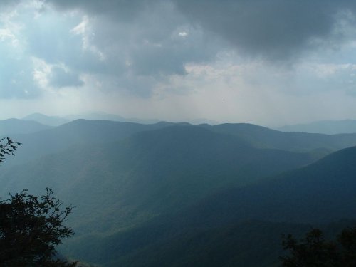
The
look out gives a awesome glimpse of the wilderness and mountains
around. People were lying around the lookout rock as if they just came
back
from an
Olympic marathon :). Finally everyone was motivated to have some food
and
their
sports drink. We spent about half and hour on the look-out and
then
started our journey back to the parking lot.
Get to the look out
and all the agony of the frustrating trail is gone!
The
look out gives a awesome glimpse of the wilderness and mountains
around. People were lying around the lookout rock as if they just came
back
from an
Olympic marathon :). Finally everyone was motivated to have some food
and
their
sports drink. We spent about half and hour on the look-out and
then
started our journey back to the parking lot.
To return back we took
the lower ridge trail. It is 4 miles total
and a
steep one even to get down (don't forget that we still couldn't get our
socks/shoes to dry so we all had wet toes :( ). This trial was even
badly hit
with the hurricanes and at couple of sections it was hard to find a way
past
the huge fallen trees. One thing the beginners failed to realize
was to
enjoy the hike downhill as much as they enjoyed (?) the uphill, so it
was frustating for some that the climb down wouldn't end sooner. It
took
us
about 2 hrs to get to the camping ground from where the parking lot was
further
10 mins. The last thing one wanted was to stay in those wet shoes. All
of us
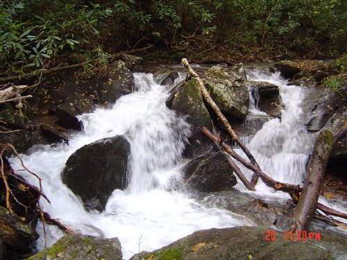
got off our shoes and soaked our feet into the freezing creek water. It
was
quite soothing despite being cold.
To get back to
Overall all I n'joyed the trek a hell lot (can't say the same for all
others in
the group. I am sure they can't complain since they asked for a longer
hike :D
). Though we missed one of the important turns I would say the trail is
well
marked all along (both the trails Kemsey Creek and Lower Ridge are
blazed blue).
Just make
sure to take the right turn after the barrier on the gravel road iron
barrier
(just in case it slipped off your mind during the first two reminders
;) ) and you are good to go for one of the refreshing treks.
Photos
Links to description about the trail
Sherpa
Guides
Tony's
Hiking Page
© Ranjit