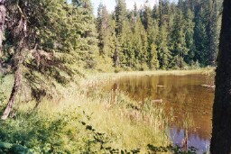
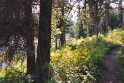
 |
 |
 |
 |
 |
 |
 |
 |
 |
 |
 |
 |
 |
 |
 |
|
|
Trail 81 Lost Lake |
|
|
|
 |
|
|
|
To reach the trail from Priest River, cross the Pend Oreille River using the Wisconsin Street bridge,and then take Dufort Road east to Highway 95. Turn left on Highway 95 (towards Sandpoint) and follow it to Sagle Road. Turn right on Sagle Road and follow it to Garfield Bay Road. Follow Garfield Bay Road to Garfield Bay. Turn left on the first road past the Forest Service Campground and go uphill to Mineral Point Road 532. Turn right onto Road 532 and follow it 4.2 miles to the end of the road. There you will find ample parking and the Lost Lake trailhead. |
|
|
|
Alternative driving directions:
Take Highway 2 east out of Priest River and follow it to Highway 95 in Sandpoint. From Sandpoint take Highway 95 south 6 miles to Sagle Road. There are signs for Garfield Bay at the Highway 95/Sagle Road intersection. Turn left onto Sagle Road and follow the road for 8.5 miles, staying right at the fork pointing to Garfield Bay Road. Proceed to Garfield Bay and go past the Garfield Bay Picnic Area and Campground. At the next fork, go uphill to the left. In the next quarter mile look for the sign for Trail 82 and turn right. You will be on Road 532. Follow it 4.2 miles to the end of the road. There you will find ample parking and the Lost Lake trailhead. |
|
 |
|
|
|
|
|
View of Lost Lake from the Trail |
|
|
|
|
|
 |
|
|
|
|
|
Lost Lake Trail |
|