 |
|
|
|
|
|
|
|
|
|
|
|
|
|
|
|
|
|
|
|
|
|
|
|
|
|
|
|
|
|
Trail 3 - Gold Hill |
|
|
|
 |
|
|
|
You may have seen travel brochures showing mountain bikers on a trail overlooking the city of Sandpoint and the Long Bridge across Lake Pend Oreille and wondered where the pictures were taken. Wonder no more! Trail 3 will take you to the viewpoint on Gold Hill where you can see Sandpoint, the Long bridge, and the beginning of the Pend Oreille River valley. You can reach the viewpoint via an arduous hike up Gold Hill (3.5 miles) from the lower trailhead or you can drive to the upper trailhead and hike down Gold Hill about a 0.2 miles. |
|
|
|
 |
|
|
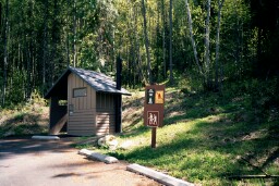
The photograph at the right shows the lower trailhead located off Bottle Bay Road. Go south from Sandpoint on Highway 95, cross the Long Bridge and continue for a short distance, then turn left onto Bottle bay Road and go approximately 4.8 miles. The lower trailhead will be on your right. Ample parking is available at the Lower Trailhead as is a restroom facility (pictured). The Lower Trailhead elevation is 2200 feet. |
|
|
|
|
|
|
 |
|
|
Allow 2 hours for the hike. |
|
|
|
|
|
 |
|
|
|
|
|
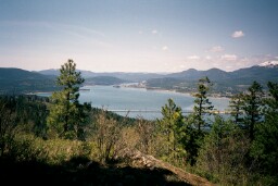
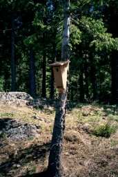
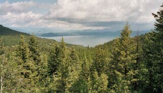
The trail leading up the hill has several switchbacks and is initially quite steep. After a mile or so, you will arrive at a bench from which you can catch a good view of Lake Pend Oreille. From here to the top, the trail is not as steep as the initial portion. Once at the top you will see several nesting boxes for the Northern Flickers (left), the Pend Oreille River Valley (top left), and Sandpoint nestled beneath Baldy Mountain (bottom left). |
|
|
|
|
|
|
The elevation change is 1200 feet. |
|
|
|
|
|
|
|
 |
|
|
|
|
|
|
|
|
|
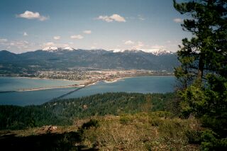
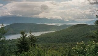
You can drive to the Upper Trailhead (pictured at right) by going south on Highway 95 from Sandpoint until you reach Garfield bay Road (about six miles). Turn left onto Garfieild bay Road and go another six miles to the hairpin turn (about a mile short of the Bay itself). Turn left just before you complete the hairpin turn onto Sky Meadow Road (fomerly known as Contest Mountain Road; also known as US Forest Service Road 2642). The Upper Trailhead is six miles from the hairpin turn. On the way up you can see Lake Pend Oreille (far right, top) and Bottle Bay (far right, bottom). |
|
 |
|
 |
|
|
|
|
|
|
|
Upper Trailhead elevation is 3400 feet. |
|
|
|
|
|
|
|
 |
|
|
|
|