Earthquakes caused by dams
R. Ashok Kumar
Naturalecologies, 1/13 Telec Officers’ C.H.S., Ltd., Plot 30, Sector-17, Vashi, N. Mumbai-400703, Maharashtra, India.
E-mail: [email protected]
18 July 2004, Revised 13 February 2005
Abstract
The paper examines the consequences of harnessing rainfall in surface water storages behind some 4000- 4500 dams on the Indian plate. At the center of gravity of these water masses in India, the load changes from zero at the commencement of the monsoon to 350 billion tons by end September, in 4 months. This is a giant wave of changing load at the rate of 33000 tons per second or equivalent to a rapidly rising water column head of 33 kilometers per square meter every second at the center of gravity for 4 months of the monsoon. This is a pressure wave of 325 million newtons per square meter per second or 325 million pascals per second! The center of gravity is at (23,78.75) between Piparia and Gadarwara in Madhya Pradesh. At the Sagaing fault between the Indian and Eurasian plates, the rate of change of water moment and consequent rate of change of bending moment reaches 600 million megawatts of power during the monsoon. The rate of release of forces at the center of gravity during the dry season is half the monsoon rate. The bending moment is also released at half the monsoon rate. Thus what we are witnessing is geological magnitude changes taking place in an instant, rivaling the effects of tectonic plate forces. During the hydrological year June 2000 to May 2001, total seismic moment of 987 *10^19.05 Nm(Newton-meters) was released east of the center of gravity and the corresponding rate of change of water moment applied was 1183*10^19.05 Nm at the Sagaing fault. This is a rate of change of water moment application at a power of 420 million megawatts. The corresponding seismic moment released was at the rate of 350 million megawatts power. The article provides epidemiological evidence and correlation with stress relief in rocks to show that the force and moment waves, because of dams on the Indian subcontinent are a cause of the persistent wave of world wide earthquakes. The article shows that the pendulum of the earthquake wave has synchronised with the pendulum of the applied rate of change of water moment. The dams have unwittingly set off a giant experiment in chaos. In the light of the tsunami that occurred on 26th December 2004 because of a great earthquake of 9.3 moment magnitude in the Andaman Basin, this research finding calls at least for an application of the precautionary approach towards the building of further dams on the Indian plate.
Summary
This paper furnishes statistically highly significant whole earth epidemiological evidence that dams on the Indian plate in India are a cause of worldwide earthquakes in the range 1-9.9 MW. The rates of change of water moment exerted on faults by the water masses behind dams cause earthquakes to occur on account of the well- known stick-slip phenomenon. The ratio of the arms of the initiating water moment on either side of the center of gravity of the water masses controls the ratio of the corresponding seismic moments in a persistent manner recurring with each hydrological cycle: the monsoons and the dry season of water withdrawal: the cumulative mean of the ratio of the annual sum of the seismic moments north of the center of gravity to the total annual sum converges to the mean of the corresponding ratio of the leverage arms of water moment for moment magnitude range 5.5-9.9 MW(ratios east of the centre of gravity to the total for 1-9.9 MW). The monthly rates of change of water moment as measured by the monthly all India rainfall govern the number, location, depth and seismic moment magnitude of the earthquakes occurring worldwide. This is because the rainfall is harnessed by storing the water behind dams. The monthly rates of change of water moment cause the monthly sums of these parameters to be statistically highly significantly proportional to the corresponding rates of change of water moment(when expressed as percentages of the wet and dry season sums of the respective variables). This robust control of the earthquake parameters allows us the use of a scaling procedure for measuring the total annual rate of change of water moment as a function of the dam storage and the water moment arms. It turns out that the cumulative mean of the ratio of the annual seismic moment sum to the annual rate of change of total water moment converges to the stress relief ratio in rocks persistently with extreme statistical significance. The variations of the cumulative annual sums of the earthquake parameters are practically completely explained by the variations of the corresponding annual cumulative sums of the rapidly changing dam storages. The paper tests these results against the earthquake data for the pre-dam era and the transition to the era when dams exert significant control over earthquakes. There is no significant statistical correlation between water moment changes (monthly rainfall during monsoon and the rate of release of water moment during the dry season) and earthquake parameters in the pre-dam era or the incipient dam era. This contrasts with the results for the dam era(all values expressed in percentages of the respective seasonal totals). The control over earthquakes by dams each hydrological year becomes stronger and stronger(statistically significant logarithmic regression with dam storages) as more and more dams are commissioned on the Indian plate with consequent increase in the effect of the monthly rains and the total monsoon rains in the same fixed time span (in 4 months of monsoon and 8 months of dry season) .
An important conclusion is that this is a giant global experiment set off by the dams resulting in a chaotic system, whereby the pendulum of the earthquakes synchronises with the pendulum of the rate of change of water moment.
Key words: hydrological cycle, dams, rate of change of water moment, Indian plate, force and moment waves, earthquakes, geostatistics, epidemiological evidence, chaos.
0.0 Introduction
The 8.0 MW earthquake at Bhuj, 23.42 N latitude and 70.23 E longitude, on 26th January 2001, was preceded and followed by a number of earthquakes worldwide. The pattern depicted by this phenomenon raised a question whether the archimedian lever effect caused by the oscillating weight of waters behind large dams on the Indian tectonic plate caused earthquakes worldwide. The dynamics of the rigid tectonic plates, which are inter-connected appeared to be affected by the rapidly rising concentration of waters behind dams during the gigantic transfer of rain-waters from the oceans to the Indian subcontinent by the South-West monsoon and by the withdrawal of the waters during the dry season thereafter. The annual rains of 1500 mm on India’s land area of 3.287 million square kilometers do not occur all at once but in a sequence on the Indian subcontinent. The trees distributed all over India, if of adequate dry biomass density, automatically and equitably distribute the rains amounting to a maximum of 7070 billion cubic meters (bcm) in sequence all over India and ensure that the changing moments exerted by the weight of lake waters are lightly borne by the earth : Nature however evolved to provide the once abundant and dense forests on the Indian landmass to utilize this water transfer by the action of the sun, transpiration and the osmotic action of the roots of vegetation during repeated cycles of rains and dry periods as the monsoon progressed. This allowed the rain to seep into the soils gently replenishing the groundwaters and maintaining ecological balance. There was natural automatic intrinsic control of equitable distribution of the monsoon bounty regulated by the density of vegetation. It was in this context that the population on the Indian subcontinent remained stable between 120-140 million people for at least two thousand years(Kingsley Davis 1951).
By 1850 when modern intervention finally began upsetting this balance with the onslaught on the forests- the rain machines- and a series of specialist - knowledge based changes in the way of life of the people were forcefully enforced, the population began to rise and by 2000 had reached a billion - a far cry from the balance of 120-140 million and is still rising. One of these harsh measures was the large dam (anticipating the results of this article) in lieu of the forest- the infinitely superior dam!
0.1 Water utilization in the paleo- era and the dawn of dams
With the large-scale deforestation, the devastation of the lifestyle and the concentration of rainwaters behind giant dams, the automatic intrinsic control of water vanished and with it the equitable distribution of rains in proportion to the density of the vegetation. Relentlessly dry land agriculture and forest based life was sought to be replaced by that based on large dams.
0.2 The Indian Tectonic Plate and Dams
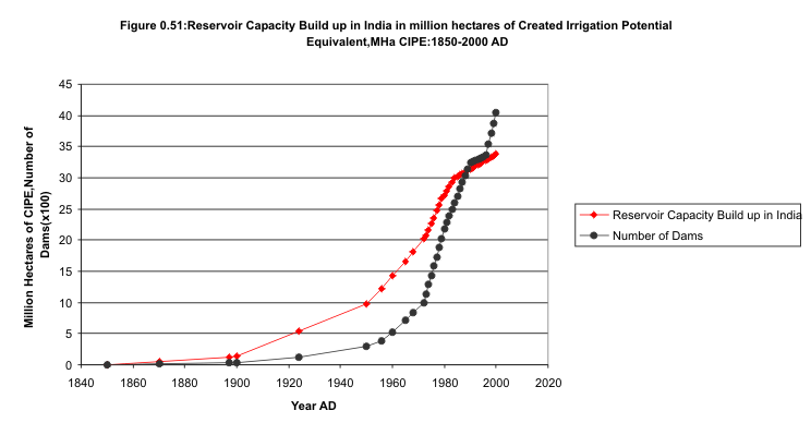
The Indian tectonic plate is unstable and dashed against the Eurasian plate and is diving under it disappearing at the rate of 6 cm per year. Is man’s intervention into this dynamic process by building large dams on the Indian subcontinent a cause of the striking regularity in the pattern of earthquakes worldwide? Figures 0,13 to 18a, on the dam era on the India part of the Indian plate indicate the unique feature of the rapid changes in water moment brought to bear on faults from circa 1870 onwards compared to the pre-dam era. Throughout this article, the reservoir capacities are expressed in created irrigation potential in million hectares(Mha CIPE) ,unless expressed in billion cubic meters (bcm).
The principles of geodynamics support the question posed above as a feasible proposition (Turcotte & Schubert 2002). At the Himalayan Frontal Thrust fault, the subduction zone arc is large and thus this question is pertinent (Tanimoto 1998). Similarly seismicity rate is a function of stress change and seismic hazard is strongly influenced by earthquake interaction(Stein 1999); interpretation of earthquake scaling significantly progressed with the recognition of a connection between fault-related processes and critical phenomena in other physical systems, together with numerical models of repeated earthquakes(Heimpel 1997). Also the finding that stressing rate governs seismicity (Toda et al 2002) lends support.
0.3 The hypothesis
In this article a hypothesis is proposed that the rapidly changing weight of waters behind dams on the Indian subcontinent exerts rapidly changing moments on inter- and intra-plate faults, which display stick-slip behaviour causing earthquakes worldwide with a regularity typical of the South-West monsoon on the Indian subcontinent, followed by water withdrawal during the dry season. The hypothesis is tested by a statistical analysis of earthquake data and its correlation with the water moments caused by dams. Dams other than the Indian are excluded from the study. The reasons are as follows. Assuming that the results of the study show a statistically significant result that the dams on the India part of the Indian plate are causing worldwide earthquakes, there are two possibilities for the result for a study with the other dams: Either the result is significant, in which case the others act similar to the Indian, or the result is not significant, in which case the other dams do not cause worldwide earthquakes. This paper deals with the fundamental question, whether the Indian dams are causing worldwide earthquakes.
0.4 The Water Moment and its rate of change.
The 124 year rainfall data (1871-1994) for each month from June to September was used to compute the mean rainfall and the running mean rainfall for each of these months for India and expressed in per unit (p.u) of the running mean rainfall total for June to September. The monthly rainfall is taken as a measure of the change in the water moment during the month. The weight of water acting at the center of gravity of all the water masses behind the reservoirs exerts moments in all directions about the centre of gravity. This moment becomes effective whenever a fulcrum is offered at the intra and inter-plate faults among the rigid tectonic plates(stick-slip phenomenon). The dry season period from October to June witnesses water withdrawal from the reservoirs and is assumed to be a linear draw-down from 1.0 p.u storage at the begin of October to 0.0 p.u storage by end of May. It is not the water moment, but its rapid rate of change that is being studied here for its effects. Today simultaneously, behind dams on the India part of the Indian subcontinent more than 300 billion cubic meters(bcm) of water are collected each year during the monsoon. The dam storages rise from zero at the commencement of the monsoon to more than 300-400 bcm in just 4 months. This is withdrawn in 8 months of the dry season from October to May. Thus at the centre of gravity(23,78.75) of these water masses, a gigantic wave of the rapidly changing vertical load rose from zero to 300-400 billion tons in 4 months of monsoon and slumped to zero by end May. This is a force application at the centre of gravity of the water masses whose wave rose at the rate of about 326 million newtons per second during the monsoon. During the dry season from October to May, this was reduced progressively to zero by release of a wave of force at half this rate! This caused a total rate of change of water moment on the Sagaing fault during the 2000-2001 hydrological year of the order of 1183*10^19.05 Nm. This corresponds to a wave of bending moment at the Sagaing fault changing at the rate of 420 million megawatts of power during the whole year! Note that during four months of the monsoon, one half of the total rate of change of water moment of 1183*10^19.05 Nm was applied on the Sagaing fault which is a rate of change of applied bending moment of 630 million megawatts power. During the dry season of eight months, the remaining half of the change in bending moment was released at half this rate or 315 million MW. During the same year the total seismic moment released during 1-9.9 MW earthquakes in the region -90 to 90 degrees latitude and 78.75 to 180 degrees longitude was 987 *10^19.05 Nm(Table 7).This is an average energy release at 351 million MW of power!. So we are dealing with geological time scale and type variations in an instant(everysecond of every year). Such gigantic waves of repeated alternating rate of change of moment applications throughout the year, every year, on faults, and their consequences, form the subject matter of this article.
1.0 A study of the USGS database on worldwide earthquakes in the range 1-9.9 MW brings out the following findings:
1.1 Highly significant correlation of percentage values of earthquake parameters with percentage rate of change of water moment.
The monsoon and dry season earthquake parameters latitude, longitude, depth, seismic moment and the number of earthquakes summed up each for each month, cumulatively for each year, and expressed in percent of the wet and dry season sums respectively, display statistically highly to extremely significant linear regression, when correlated with the corresponding monthly percent rate of change of water moment. See Table 1 below:
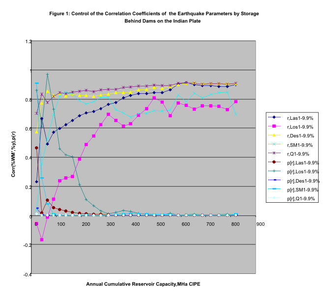
1.2 The linear regressions for each year correlate with the yearly cumulative reservoir capacities in a logarithmic regression.
The trajectory of the Linear Regression correlation r (%WM’, %y, an earthquake parameter) of the cumulative monthly sums of the earthquake parameters with the annual
cumulative reservoir capacity (June 1973-May 1974,June 1973-May 1975,…June 1973-May2001) for the various earthquake parameters is shown in Table 1a and Figure 1 below: This regression is logarithmic and is statistically extremely significant as shown in Table 2. The reservoir capacity (and water storage) is given in million hectares created irrigation potential equivalent(Mha CIPE). The reservoir capacity in billion cubic meters is got by multiplying the reservoir capacity expressed in million hectares created irrigated potential equivalent(Mha CIPE) by the factor (water application at canal head in meters/efficiency of water storage)
|
June’73- May’01 |
WM' |
Las1-9.9 |
Los1-9.9 |
Des1-9.9 |
SM1-9.9 |
Q1-9.9 |
Mean% |
|
Month |
Percent |
Percent |
Percent |
Percent |
Percent |
Percent |
|
|
6 |
19.181148 |
25.429862 |
29.10169 |
24.438377 |
31.24519 |
24.91238 |
27.0255 |
|
7 |
32.18709 |
26.663597 |
24.81281 |
25.336021 |
25.93953 |
26.4197 |
25.83433 |
|
8 |
28.573456 |
24.430436 |
27.17635 |
26.23777 |
22.08133 |
24.93365 |
24.97191 |
|
9 |
20.058307 |
23.476088 |
18.90915 |
23.987832 |
20.73396 |
23.73427 |
22.16826 |
|
10 |
12.5 |
12.115886 |
8.130107 |
12.620119 |
18.20424 |
12.24837 |
12.66374 |
|
11 |
12.5 |
11.285639 |
14.59941 |
12.416811 |
19.63303 |
12.13443 |
14.01386 |
|
12 |
12.5 |
12.670576 |
16.74187 |
12.336379 |
9.355817 |
12.20231 |
12.66139 |
|
1 |
12.5 |
12.620274 |
10.26565 |
12.364672 |
10.3446 |
12.54121 |
11.62728 |
|
2 |
12.5 |
11.075161 |
17.29124 |
11.078226 |
8.322228 |
11.4193 |
11.83723 |
|
3 |
12.5 |
13.272122 |
11.02144 |
12.726306 |
10.53964 |
12.95477 |
12.10286 |
|
4 |
12.5 |
12.966297 |
13.3188 |
13.064323 |
10.10264 |
12.88302 |
12.46702 |
|
5 |
12.5 |
13.994034 |
8.631494 |
13.393163 |
13.49781 |
13.61657 |
12.62661 |
|
Linear Reg. |
Corr. with |
Las1-9.9 |
Los1-9.9 |
Des1-9.9 |
SM1-9.9 |
Q1-9.9 |
Mean% |
|
|
%WM' |
Percent |
Percent |
Percent |
Percent |
Percent |
|
|
|
m, slope |
0.8002247 |
0.795985 |
0.8005167 |
0.7374 |
0.803526 |
0.78753 |
|
|
b, intercept |
3.3295866 |
3.400249 |
3.3247209 |
4.376674 |
3.274565 |
3.541159 |
|
|
r, Correlation coefficient |
0.8972697 |
0.779359 |
0.9040478 |
0.693817 |
0.906969 |
0.878747 |
|
|
df |
10 |
10 |
10 |
10 |
10 |
10 |
|
|
t |
6.4270123 |
3.933355 |
6.6884436 |
3.046643 |
6.809385 |
5.822148 |
|
|
P, probability |
7.567E-05 |
0.002805 |
5.442E-05 |
0.012322 |
4.69E-05 |
0.000168 |
|
|
tails |
2 |
2 |
2 |
2 |
2 |
2 |
Table 1:June 1973 to May 2001: The earthquake parameters correlate in linear regression statistically highly significantly with the monthly rate of change of water moment(WM’).Here Las1-9.9 means latitude sum for earthquakes in the range 1-9.9 MW; Los: Longitude sum; Des: Depth sum; SM: Seismic Moment sum, Q : Sum of Number of earthquakes and Mean stands for the mean of the earthquake parameters just stated. In this table the wet season values(June to September) are expressed as a percentage of the wet season sum and the dry season values(October to May) as a percentage of the dry season sum.
|
|
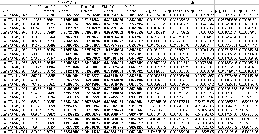
Table 1a: How the linear regression of the cumulative values of the earthquake parameters for each month with cumulative mean of the monthly rate of change of water moment changes with the cumulative reservoir capacities(Mha CIPE) from year to year. The seasonal values are expressed in percent of the respective seasonal sums . See Figure 1 and Table 2 below.
June 1973-May2001
|
|
Las1-9.9 |
Los1-9.9 |
Des1-9.9 |
SM1-9.9 |
Q1-9.9 |
|
|
Percent |
Percent |
Percent |
Percent |
Percent |
|
LR,r(LnCumRC,y) |
0.94959924 |
0.960344824 |
0.85283204 |
0.71034317 |
0.94253201 |
|
t,student’s t dist |
15.4467037 |
17.56295943 |
8.3277086 |
5.14601884 |
14.3841994 |
|
p,probability of t |
1.2943E-14 |
6.09219E-16 |
8.2644E-09 |
2.2868E-05 |
6.8451E-14 |
|
m,slope |
0.15583592 |
0.292475168 |
0.05846966 |
0.12820331 |
0.04594428 |
|
b,intercept |
-0.12572784 |
-1.123686124 |
0.51765386 |
-0.00537991 |
0.60677951 |
Table 2: The correlation coefficients of linear regression of the monthly cumulative sums of each earthquake parameter in the range 1-9.9 MW for each year during the period June 1973 to May 2001 displays a logarithmic relation with the annual cumulative reservoir storages of dams in India. This points towards the fact that the rate of change of water moment as measured by the monthly rainfall on India seen above to be persistently governing worldwide earthquakes is caused by the dam storages. The logarithmic relation is given by y=b +m* ln Cum RC, where CumRC is the annual cumulative sum of the total of the reservoir storage capacities in India in Mha CIPE,m is the slope and b the intercept. Mha CIPE stands for million hectares of created irrigation potential equivalent.
1.3 The F-Ratio Test on the Earthquake Parameters and the Rate of Change of Water Moment
The F-Ratio Test for the variables %WM’ and the earthquake parameters of Table 1 shows that they all come from the same parent population. See Table 3 below.
|
Jun73-May01 |
WM' |
Las1-9.9 |
Los1-9.9 |
Des1-9.9 |
SM1-9.9 |
Q1-9.9 |
|
|
Percent |
Percent |
Percent |
Percent |
Percent |
Percent |
|
sdp |
6.704288885 |
5.97783 |
6.835269 |
5.935884 |
7.12527795 |
5.938399 |
|
F |
|
1.25782 |
1.039455 |
1.275659 |
1.12953107 |
1.274579 |
|
p(F) |
|
0.355151 |
0.474991 |
0.346715 |
0.42175943 |
0.347221 |
|
df |
11 |
11 |
11 |
11 |
11 |
11 |
Table 3: The F-Ratio Test for the earthquake period June 1973 to May 2001 for the variables of Table 1 shows that they all come from the same parent population.
The F-Ratio Test provides further evidence that the rate of change of water moment and hence the dam storage variations govern the earthquakes persistently. Here sdp is the standard deviation of the population, p(F) is the probability of the F-Ratio being exceeded by chance and df is the number of degrees of freedom. The F-Ratio probability shows that the percentage rate of change of water moment and the various earthquake parameters in percentage are statistically not significantly different.
1.4 The Relation of the Seismic Moment to the Water Moment.
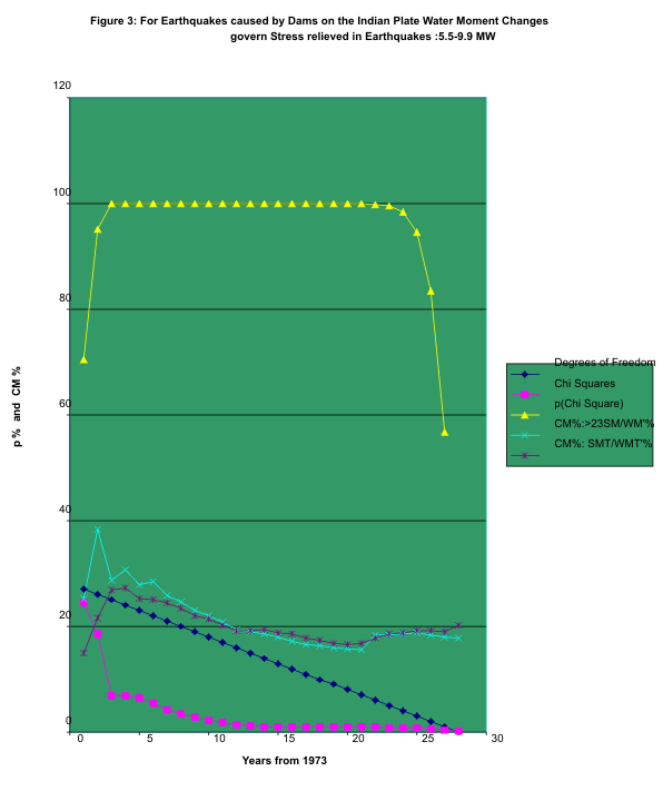
For the 1973-2001 database when the annual rate of change of water moment(see sections 1.4.2 to 1.4.2.3, for the computation of this variable) is compared with the annual seismic moment sum for all earthquakes in the 5.5 –9.9 MW range, it is found that the cumulative mean of the ratio of the seismic moment sum to the corresponding rate of change of water moment for each year to be statistically the same as the stress relief ratio for rocks , that is, stress relieved from rocks during earthquakes as a percentage of the stress built up in the rocks prior to earthquakes(19.743%, Turcotte and Schubert 2002). See Table 4 and Figure 2.
Table 4 : URL: http://www.geocities.com/rakumra/image004.gif
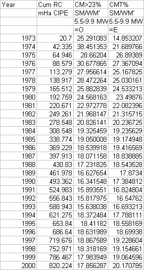
Table 4:Cumulative means(CMs) of the ratio seismic moment sum to rate of change of water moment for each year during June 1973 to May 2001 in percent are shown for two areas: For latitudes >23 degrees and for all latitudes, all for 5.5-9.0 MW earthquakes. The chi squared test shows that these ratios are statistically the same- the difference between them is due to chance. Also as shown by the chi-squared test the stress relieved ratio in rocks follows this ratio. See Figure 2.
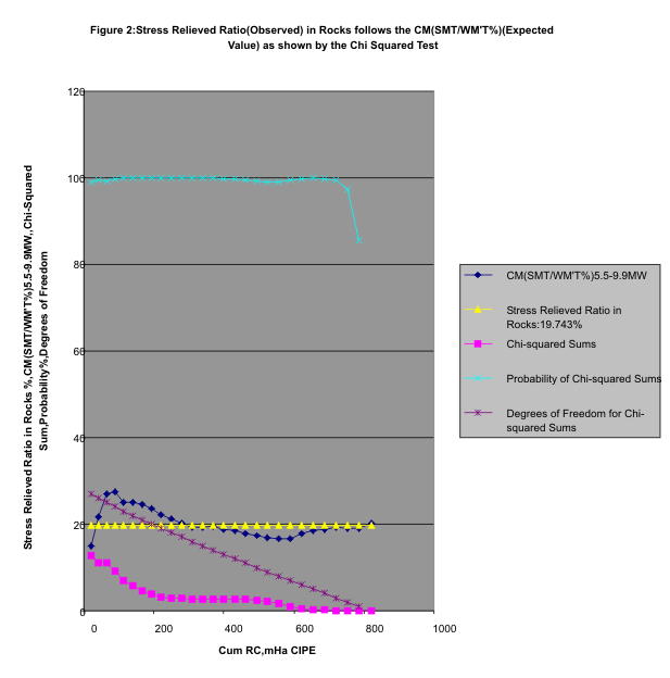
1.4.1 Stick-slip behaviour of rocks controlled by water moment changes
As shown in Figure 3 below, for the 5.5-9.9 MW earthquakes, the statistical difference between the two sets of ratios- CM>23(SM/WM’%) and CM SM/WM’% is due to chance. The ratio for >23 latitude earthquakes for water moment exerted by the water masses acting through their center of gravity at ( 23,78.75),on the Himalayan Frontal Thrust converges to the overall ratio and both of these converge to the stress relieved ratio in rocks. Thus the rate of change of water moment exerts a changing bending moment causing stresses to develop in the faults, which then exhibit a stick-slip behaviour.
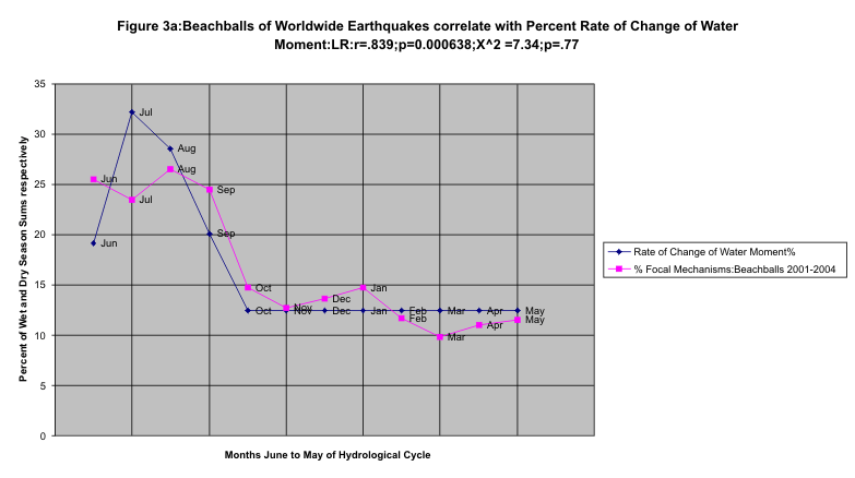
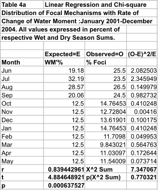
1.4.1.1 Percent Focal Mechanisms per month correlate with Percent Rate of Change of Water Moment
This connection to the rock stresses was confirmed by correlating beachball representations(focal mechanisms) with the monthly rates of change of water moment: See Figure 3a and Table 4a. Those which exhibited tension at the top end of the beachball representation, were counted for each month for each hydrological year. The mean count for each month was expressed as a percentage of sum of such means for the two seasons respectively. When the percent mean counts were correlated with the percent rates of change of mean water moment in linear regression, it was found that the foci exhibit a statistically extremely significant correlation: r=0.839,p=.000638. Further, the chi-square distribution is 7.38 with p=0.77,degrees of freedom 11, showing that the differences between the two quantities are due to chance. Thus, when put in the perspective of this article, the stresses in the rocks are persistently controlled by the rate of change of water moment.
1.4.2 The nature of the initiating water moments: On what faults are the water moments initially exerted? The significance of the mean value of the earthquake parameter.
With such a robust control of the earthquake parameters exhibited by the rate of change of water moments, it needs to be asked whether the mean value of the earthquake parameter tells us something more of the nature of the initiating water moments, interaction of the earthquake parameters with the water moments exerted by the water masses behind dams on the Indian tectonic plate and the location of the faults on which the initiating water moments are exerted. One of these primary faults has been indicated above as the Himalayan Frontal Thrust. The other fault on which the water masses exert changing bending moments through their center of gravity located as stated above is on one of these, for the 5.5 to 9.9 MW earthquakes: the Owen Fracture Zone, the Carlsberg Ridge and the Mid- Indian Ridge. As the rigid plates are interconnected at their boundaries, these water moments are transmitted to faults on other plates or their boundaries. As they also exhibit stick-slip behaviour, they would also ultimately fail, causing earthquakes. These inferences are arrived at for earthquakes in the magnitude range 5.5-9.9 MW and for the range 1-9.9 MW on the basis of the following analysis:
1.4.2.1 The scaling procedure
On account of the control exerted by the rate of change of water moment on the earthquake parameters, the mean hypocenter for a quake in any year as given by the latitude per quake ,the longitude per quake and the depth per quake(determined as the sum of the values of the parameter under consideration divided by the number of earthquakes during the period) is used to derive values for the initiating or earthquake triggering water moment arms. On a two dimensional tectonic map of the world(Cartographic Division,National Geographic Society 1995) (See Figure 3.1, below), the mean location for a quake in any given year is plotted and joined by a straight line to the center of gravity (CG) (23,78.75), of the water masses behind dams in India (on the Indian plate) )(See Appendix A for the derivation of the location of the centre of gravity). This line is then extended upwards to meet the Himalayan Frontal Thrust (HFT) fault line in the north. In the south the line crosses the Owen Fractured Zone (OFZ) or the Carlsberg Ridge (CR) or the Mid- Indian Ridge (MIR). The two water-moment arms are then 1)CG-HFT and 2)CG-OFZ or CG-CR or CG-MIR. The total water moment arm for computation of the total rate of change of water moment is then HFT-OFZ or HFT –CR or HFT-MIR. These statements hold good for earthquakes in the range 5.5-9.9 MW during the period June 1973-May 2001. It is noteworthy that for this period of the study, the limits as shown in Figure 3.1 for these lines are a narrow band and they all intersect the Himalayan Frontal Thrust north of the centre of gravity, CG and either of the three faults as mentioned above, south of the centre of gravity,CG.
1.4.2.2 The scaling method(continued)
Table 5 displays the data for the figures displayed above for earthquakes in the range 5.5 to 9.9 MW for the years 1973-74 to 2000-01. It shows how the water moments are
computed which are acting on the faults which exhibit a stick- slip behaviour resulting in earthquakes due to these water moments. This should be referred to in connection with Figure 3.1 which illustrates the situation created by the water moments and their changes due to the monsoon and the dry season. During the monsoon the reservoirs fill up increasing the bending stresses on the stick- slip faults resulting in earthquakes when the faults snap. During the dry season when water is being withdrawn for use, these moments are released resulting in stress relief and again consequent earthquake occurrence. A similar situation exists for the earthquakes in the range 1-9.9 MW resulting in ratios statistically indistinguishable to those for 5.5-9.9 MW quakes (See Figure 4).
1.4.2.3 Computation of the rate of change of water moment for any year for worldwide earthquakes.
Let us first take the earthquakes in the range 5.5 to 9.9 MW. Let us take the year 1973(See Table 5). Corresponding to the location, [(mean latitude, Las/Q, mean longitude, Los/Q)]=(4.27108,
60.7636), a line is drawn on a two dimensional tectonic map, connecting this hypothetical epicenter to the center of gravity,CG, of the water masses (23,78.75)(See Figure 3.1,below). This straight line passes through a point say MIR, on the Mid Indian Ridge below the centre of gravity, CG and meets the Himalayan Frontal Thrust fault, at say HFT, north of the CG. On the map(scale 1 inch=758 miles at the equator), these arms of the water moment CG-MIR and CG-HFT measure 6.7 cm and 2.1 cm respectively. The total of the two water moment arms (CG-MIR+CG-HFT) is 8.8 cm(called the total water moment arm and denoted by WMAT). The water moment arm above CG (above 23 degrees latitude),CG-HFT, is called WMA>23,for the arm meeting the Himalayan Frontal Thrust. This is entered in the column captioned WMA>23 and the value for the year 1973 is 2.1. The next column is the worldwide sum of the seismic moments in the range 5.5 to 9.9 MW for each year; for 1973, the value is 223.1*10^19.05 N-m. For all earthquakes worldwide occurring in latitudes>23 degrees latitude, the seismic moments in the range 5.5 to 9.9 MW are summed up and entered in the column marked SM>23. The value for 1973 is 90.6*10^19.05 N-m. The total rate of change of water moment for any year in Newton-meters/year is given by twice the product of the weight of water masses behind dams(Newtons) and the sum of the water moment arms north and south of the centre of gravity of the water masses (CG) in meters. This is because at the end of the monsoon the rate of change of water moment as measured by the total rainfall is a maximum equal to the total reservoir capacity on the India part of the Indian tectonic plate. During the dry season, October to May, this water is withdrawn for use, till the reservoirs are empty by the end of May. So the total rate of change of water moment during the dry season, October to June ,is measured by the total water storage available at the end of the monsoon. This is also the total reservoir capacity because of the shortage of water on the Indian subcontinent. For comparing the effect of water storage capacities from year to year, however, the effective water moment arm from the centre of gravity of the water masses to the concerned fault must be factored in. The total rate of change of water moment in Newton-meters/year for worldwide earthquakes for latitudes greater than lat, WM’>lat, and corresponding water moment arm, WMA>lat, for any year, is given by
WM’>lat=2*RC (Mha CIPE*)[10^10 m^2]*(Water application at canal head,0.8m/Storage efficiency,0.8)(m)[m^3][10^3kg]*9.81(msec^2)[N]*WMA>lat(cm)/2.54(in)*758(miles)*1.58(km)*[10^3m] N-m/year-------------------------------------------------------------------------(1)
=9251.0617328*10^16 *RC*WMA>lat N-m/year-------------------------------------------------(2)
=(9251.0617328*10^16/10^19.05)*RC*WMA>lat *10^19.05 N-m/year---------------------(3)
=8.245017448*RC*WMA>lat *10^19.05N-m/year-----------------------------------------------(4)
Thus, for worldwide earthquakes for all latitudes and longitudes, if the total rate of change of water moment for any year is denoted by WM’T and total water moment arm is WMAT,then
WM’T= 8.245017448*RC*WMAT *10^19.05 N-m/year--------------------------------------(5)
And for worldwide earthquakes for latitudes >23 degrees,
WM’>23=8.245017448*RC*WMA>23 *10^19.05 N-m/year---------------------------------(6)
For the year 1973, RC is 20.7 Mha, WMAT=8.8 cm and WMA>23 is 2.1 cm; WM’T,from (5) works out to 1502 *10^19.05 N-m and WM’>23 from (6) becomes 358.41*10^19.05 N-m.
An assumption is made for the reservoir efficiency of 0.8 and for the water application at canal head of 0.8m, for the purposes of this study. Still with Table 5, for 1973, ratio SMT/WM’T*100= 223.1/1502*100= 14.853%. And SM>23/WM’>23*100=90.6/358.41*100=25.291%. The various ratios of the seismic moment to rate of change of water moment are entered in Table 5 as T%, meaning SMT/WM’T%; >23% meaning the ratio SM>23/WM’>23%; the cumulative mean of the ratio SMT/WM’T% is CM T%; the cumulative mean of SM>23/WM’>23% is entered in the column CM>23%. The moment magnitude range of the earthquakes for which these ratio values are entered are indicated in the respective columns as either just 5.5-9.9 or just 1-9.9. The captions O1,O2 for the cumulative ratios indicate that those ratios are used as observed values in computing
chi-squared sums; similarly the caption E indicates that the ratio is the expected value in determining the chi-square values.
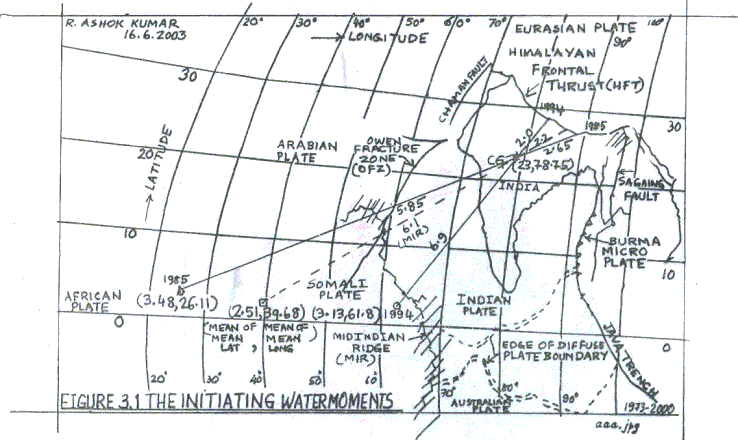
Figure 3.1: The
initiating water moments on the Indian plate.
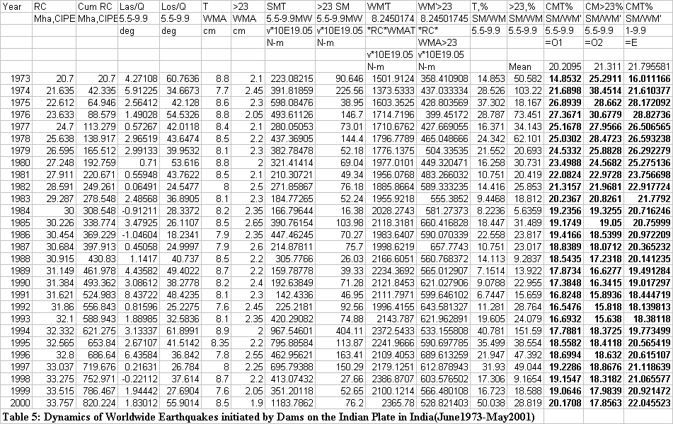
Figure 4: URL: http://www.geocities.com/rakumra/earthquakescausedbydamsr26.gif

1.4.2.4 The water moment arms ratio controls the corresponding seismic moment ratio
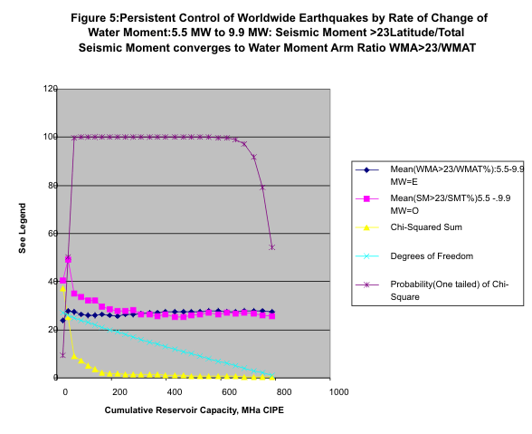
The running mean of the ratio of the seismic moments SM>23/SMT converges to the running mean of the ratio of water moment arms from the center of gravity of the water masses on the India part of the Indian plate, WMA>23/WMAT, statistically highly significantly, allowing the inference that the water moment changes are persistently causing worldwide earthquakes (5.5-9.9 MW). See Table 5a and Figure 5. For determining the Chi-square sum for the Chi-squared test, in Figure 5, as shown in the legend, the mean of the water moment arm ratio is the expected value, E; the mean of the seismic moment ratio is the observed value, O.
Table 5a: Worldwide Earthquakes:June 1973 to May 2001: 5.5-9.9 MW: The annual cumulative
mean of the seismic moment ratio >23SM/SMT% converges to the annual cumulative mean of the water moment ratio WMA>23/WMAT%. For the Chi-squared Test the cumulative water moment ratio as shown is the expected value and the cumulative seismic moment ratio is the observed value.
Table 5a:URL: http://www.geocities.com/rakumra/image008.gif

1.4.2.5 The stress relief ratio mirrored by the seismic moment to water moment ratios
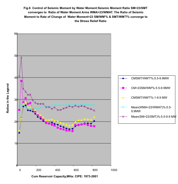
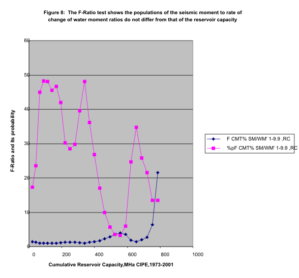
The evidence presented in the sections 1.4-1.4.2.4 shows that the stress relieved ratio in rocks for quakes in the range 5.5-9.9 MW and 1-9.9 MW is persistently controlled by the rate of change of water moment exerted by the water masses on the India part of the Indian tectonic plate. See Figure 6,which brings out the fact. While the seismic moment to water moment ratio converges to the stress relieved ratio in rocks, its variations as determined by the F-ratio test are the same statistically as those of the reservoir capacity (Section 1.4.2.6, Figures 7 & 8). Thus the stress relieved ratio in rocks is controlled by the changes in the reservoir contents.
1.4.2.6 The nature of the variations of earthquake parameters compared with that of the reservoir capacity
The population standard deviation of
the ratios referred to in Figure 6 statistically significantly do not differ
from that of the reservoir capacity for the India part of the Indian plate (See
Figure 7 and Figure 8). 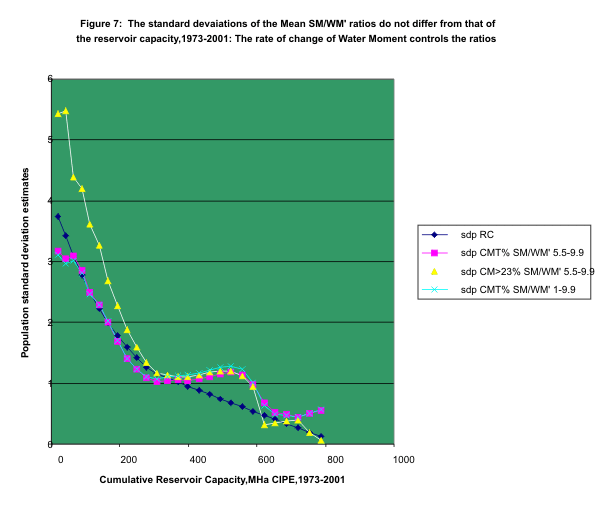
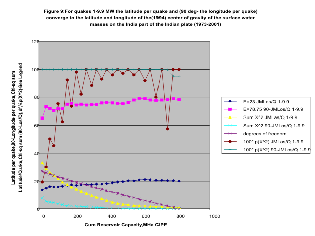
1.4.3 Analysis of Correlation of Earthquakes in the Range 1-9.9 MW with Rate of Change of Water Moment
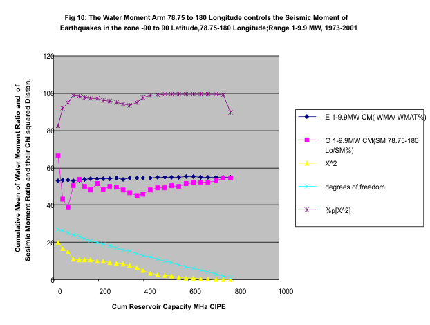
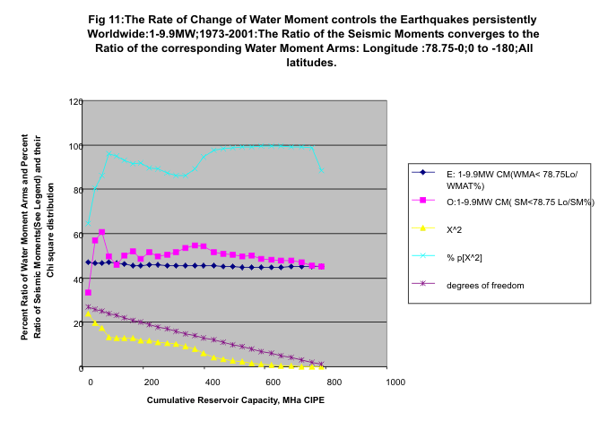
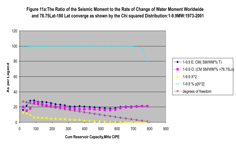
For the earthquake range 1-9.9 MW, an analysis like that for the range 5.5-9.9 MW was carried out. It is found that the mean latitude per quake and 90- mean longitude per quake for each year are not significantly different from the center of gravity of the water masses behind large and medium sized dams in India(23,78.75)(Figure 9). The corresponding water moment arms for each year hit the Sagaing fault to the right of the center of gravity (23,78.75) and pass through the Murray Ridge to the left. The cumulative mean (CM) of the seismic moment ratio in percent SM(78.75 deg. Longitude-180 deg. Longitude)/(SM Total), converges to the corresponding yearly cumulative mean of the water moment arm ratio (CG-Sagaing Fault )/(CG-Murray Ridge+CG-Sagaing Fault)) in percent. The Chi-square distribution proves this(Figure 10). Again analogous to the 5.5-9.9 MW case, the CM of the SM ratio [SM/WM’](78.75-180 Longitude) % converges to the CM of the ratio [SM/WM’](Total)%(Figure 11a).These also converge to the stress relieved ratio in rocks of 19.743% as proved by the chi-squared test. For these data, the latitude range for the earthquakes was chosen to be –90 to 90. See Tables 6 and 7. Similarly, the CM for the ratio of seismic moments SM (78.75 to 0 and 0 to –180)/(SM Total) converges to the CM of the water moment arm ratio (Murray Flt to CG)/(Sum of the Water Moment arms) (Figure 11). Also the CM of the ratio of seismic moment to rate of change of water moment , (SM/WM’%)(78.75-0,0to –180), converges to CM of [SM(Total)/WM’(Total)%](Table 7a,Figure 11b) . Both have converged to the stress relieved ratio in rocks of 19.743% again, as proved by the chi-squared test. It may be noticed that the Sagaing fault, the Burma microplate, the Indian plate are interconnected. The dams may have contributed to the triggering of the great Andaman Basin earthquake of 9.3 MW on 26th December 2004, through the rate of change of water moment.
|
Note |
JMmeans |
June to May: |
E=expected |
Sum X^2 |
Sum X^2 |
|
p(X^2) |
p(X^2) |
|
|
|
E=23 |
E=78.75 |
JMLas/Q |
90-JMLos/Q |
df |
JMLas/Q |
90-JMLos/Q |
|
Year |
Cum RC |
JMLas/Q1-9.9 |
90-JMLos/Q1-9.9 |
1-9.9 |
1-9.9 |
1-9.9 |
1-9.9 |
1-9.9 |
|
1973 |
20.7 |
13.51974548 |
64.90940835 |
33.15241625 |
7.781898301 |
27 |
0.19209 |
0.999889149 |
|
1974 |
42.335 |
14.74338852 |
73.16908507 |
29.24479773 |
5.349365257 |
26 |
0.30007 |
0.999995111 |
|
1975 |
64.946 |
15.94299747 |
72.00423109 |
26.28081369 |
4.95385273 |
25 |
0.50306 |
0.999994969 |
|
1976 |
88.579 |
15.5960185 |
70.51276744 |
24.11554043 |
4.376006405 |
24 |
0.45501 |
0.99999662 |
|
1977 |
113.279 |
15.521 |
71.59584733 |
21.73210817 |
3.514393704 |
23 |
0.75086 |
0.999999043 |
|
1978 |
138.917 |
16.25618773 |
71.63988812 |
19.30013188 |
2.86446481 |
22 |
0.62673 |
0.999999647 |
|
1979 |
165.512 |
16.89072875 |
75.01344007 |
17.32278388 |
2.222513179 |
21 |
0.92286 |
0.999999907 |
|
1980 |
192.759 |
17.02411649 |
75.41381935 |
15.70003627 |
2.045219464 |
20 |
0.73505 |
0.999999863 |
|
1981 |
220.671 |
16.86959142 |
74.42457903 |
14.1473761 |
1.903884843 |
19 |
0.97977 |
0.999999766 |
|
1982 |
249.261 |
17.12150007 |
74.78204747 |
12.51338004 |
1.666306855 |
18 |
0.81963 |
0.999999747 |
|
1983 |
278.548 |
17.43309593 |
74.36862481 |
11.01091215 |
1.466374827 |
17 |
0.99722 |
0.999999688 |
|
1984 |
308.548 |
17.37097062 |
74.49512397 |
9.663502549 |
1.2226104 |
16 |
0.8836 |
0.999999719 |
|
1985 |
338.774 |
17.84177025 |
74.60673443 |
8.285851603 |
0.992718718 |
15 |
0.99979 |
0.999999759 |
|
1986 |
369.229 |
17.85206837 |
75.78810677 |
7.129010985 |
0.774729517 |
14 |
0.92962 |
0.999999815 |
|
1987 |
397.913 |
18.0642586 |
76.16324661 |
5.976784896 |
0.663328736 |
13 |
0.99999 |
0.999999692 |
|
1988 |
430.83 |
18.54507645 |
75.77124951 |
4.917587368 |
0.578359935 |
12 |
0.96068 |
0.999999366 |
|
1989 |
461.978 |
19.10405768 |
75.35943774 |
4.054702852 |
0.465687497 |
11 |
1 |
0.999999058 |
|
1990 |
493.362 |
19.67385191 |
75.19664414 |
3.394773873 |
0.319707657 |
10 |
0.97055 |
0.999999238 |
|
1991 |
524.983 |
20.07895598 |
75.97508184 |
2.913762518 |
0.159373207 |
9 |
1 |
0.999999796 |
|
1992 |
556.843 |
20.27196277 |
77.79104147 |
2.542784336 |
0.06159326 |
8 |
0.95971 |
0.999999963 |
|
1993 |
588.943 |
20.8569015 |
79.05241379 |
2.219210981 |
0.049915782 |
7 |
1 |
0.999999793 |
|
1994 |
621.275 |
21.03878033 |
78.77452794 |
2.019520931 |
0.04875446 |
6 |
0.91789 |
0.999997629 |
|
1995 |
653.84 |
20.86009824 |
77.79261635 |
1.852286905 |
0.04874682 |
5 |
1 |
0.999972574 |
|
1996 |
686.64 |
20.57012701 |
77.51045445 |
1.653192141 |
0.037107665 |
4 |
0.7992 |
0.999829992 |
|
1997 |
719.676 |
20.42381983 |
77.80999414 |
1.396484195 |
0.017596895 |
3 |
1 |
0.999382437 |
|
1998 |
752.971 |
20.19939091 |
78.31434402 |
1.107931836 |
0.006376438 |
2 |
0.57467 |
0.996816858 |
|
1999 |
786.467 |
20.15775168 |
78.86441972 |
0.766913953 |
0.003966328 |
1 |
1 |
0.949783394 |
|
2000 |
820.224 |
19.90797066 |
78.20295662 |
|
|
|
|
|
|
Table |
The latitude per quake and 90-the longitude per quake for 1-9.9 MW range for the years 1973-2000 |
|||||||
|
6 |
converge to the centre of gravity of the water masses behind dams in India:Worldwide quakes. |
|||||||
|
1-9.9 MW Worldwide Earthquakes |
WMA |
WMA |
|
|
|
|
|
|
T |
>78.75Lo |
|
|
||||
|
|
|
|
|
|
T |
CG- |
WM'T |
WM' |
SMT |
SM78.75 |
SM/WM'% |
SM/WM’% |
E: CM( |
O: (CM |
X^2 |
% |
|
|
|
|
1-9.9 |
1-9.9 |
|
Sg'g |
|
CG-Sg'gFlt |
|
to 180 Lo |
>78.75Lo |
T |
SM/WM’%) |
SM/WM' %) |
|
p[X^2 |
|
|
RC |
|
Las/Q |
Los/Q |
cm |
cm |
<-------- |
V*10^19.05 N-m |
-----------> |
|
|
|
|
|
|
|
|
73 |
20.7 |
|
13.51975 |
25.09059 |
8.5 |
4.5 |
1451 |
768.02338 |
232.3 |
154.9177 |
20.17096 |
16.0111 |
16.011166 |
20.17096 |
13.1 |
100 |
|
74 |
21.6 |
|
15.909 |
8.962967 |
8 |
4.3 |
1427 |
767.0381 |
400.8 |
78.833 |
10.27759 |
28.08285 |
21.610377 |
15.22427 |
12.02 |
99.9 |
|
75 |
22.6 |
|
18.13651 |
20.12573 |
7.9 |
4.2 |
1473 |
783.03261 |
608.2 |
188.8723 |
24.12062 |
41.29552 |
28.172092 |
18.18972 |
10.13 |
99.6 |
|
76 |
23.6 |
|
14.55155 |
23.9768 |
8.4 |
4.4 |
1637 |
857.35979 |
504 |
424.5975 |
49.52384 |
30.79316 |
28.82736 |
26.02325 |
6.594 |
100 |
|
77 |
24.7 |
|
15.24443 |
14.41119 |
8.1 |
4.35 |
1650 |
885.8859 |
291.1 |
197.2369 |
22.26437 |
17.64865 |
26.591619 |
25.27147 |
6.321 |
100 |
|
78 |
25.6 |
|
20.30073 |
18.11783 |
7.5 |
4.2 |
1585 |
887.82018 |
445.6 |
133.5189 |
15.03896 |
28.10767 |
26.844293 |
23.56606 |
6.255 |
100 |
|
79 |
26.6 |
|
19.73825 |
-0.15235 |
7.5 |
4.35 |
1645 |
953.85164 |
392 |
145.5763 |
15.26194 |
23.83355 |
26.414187 |
22.37975 |
5.855 |
100 |
|
80 |
27.2 |
|
17.82875 |
12.17098 |
7.85 |
4.25 |
1764 |
954.806 |
330.4 |
250.1896 |
26.20319 |
18.73333 |
25.45408 |
22.85768 |
5.239 |
100 |
|
81 |
27.9 |
|
15.80564 |
22.38664 |
8.2 |
4.4 |
1887 |
1012.5574 |
219.1 |
50.6976 |
5.006887 |
11.60919 |
23.915759 |
20.87426 |
4.974 |
99.9 |
|
82 |
28.6 |
|
18.82904 |
12.79488 |
7.7 |
4.2 |
1815 |
990.07983 |
282.6 |
185.3152 |
18.7172 |
15.56652 |
23.080835 |
20.65855 |
4.587 |
99.9 |
|
83 |
29.3 |
|
19.84274 |
18.82847 |
7.65 |
4.3 |
1847 |
1038.3289 |
195.8 |
83.1752 |
8.010487 |
10.59777 |
21.946011 |
19.50873 |
4.333 |
99.9 |
|
84 |
30 |
|
16.89818 |
14.54217 |
8 |
4.3 |
1979 |
1063.6073 |
178.6 |
62.1847 |
5.846585 |
9.02375 |
20.869156 |
18.37022 |
4.062 |
99.9 |
|
85 |
30.2 |
|
21.18443 |
14.60083 |
7.5 |
4.15 |
1869 |
1034.2377 |
403.1 |
107.8048 |
10.4236 |
21.56872 |
20.922969 |
17.75894 |
3.763 |
99.8 |
|
86 |
30.5 |
|
17.94154 |
3.94768 |
7.7 |
4.2 |
1933 |
1054.5938 |
458.8 |
128.1354 |
12.15021 |
23.73106 |
21.123547 |
17.35832 |
3.285 |
99.8 |
|
87 |
30.7 |
|
20.1235 |
10.19614 |
7.5 |
4.15 |
1897 |
1049.909 |
225.2 |
120.4376 |
11.47124 |
11.86755 |
20.50648 |
16.96584 |
2.613 |
99.9 |
|
88 |
30.9 |
|
23.31206 |
18.11514 |
7.2 |
4.05 |
1835 |
1032.3236 |
316.5 |
268.1648 |
25.97682 |
17.24743 |
20.302789 |
17.52903 |
2.002 |
99.9 |
|
89 |
31.1 |
|
24.52496 |
18.63424 |
7 |
4 |
1798 |
1027.2962 |
170.5 |
110.7875 |
10.78438 |
9.481728 |
19.666256 |
17.13229 |
1.623 |
99.9 |
|
90 |
31.4 |
|
25.0929 |
16.35161 |
7 |
4 |
1811 |
1035.0465 |
204.2 |
107.0423 |
10.34179 |
11.27264 |
19.199945 |
16.75504 |
1.297 |
99.9 |
|
91 |
31.6 |
|
23.97914 |
6.530416 |
7 |
4 |
1825 |
1042.8628 |
152.8 |
100.6847 |
9.654645 |
8.370842 |
18.629992 |
16.38133 |
0.985 |
99.9 |
|
92 |
31.9 |
|
21.96223 |
-3.69438 |
7.25 |
4 |
1904 |
1050.745 |
236.8 |
104.8986 |
9.983259 |
12.43175 |
18.32008 |
16.06143 |
0.714 |
99.9 |
|
93 |
32.1 |
|
25.94145 |
-0.01682 |
7 |
4 |
1853 |
1058.6602 |
430 |
342.1599 |
32.32009 |
23.20851 |
18.552862 |
16.8356 |
0.435 |
100 |
|
94 |
32.3 |
|
22.84814 |
13.98992 |
7.15 |
3.95 |
1906 |
1052.9827 |
979.9 |
605.8346 |
57.53509 |
51.4114 |
20.046432 |
18.68562 |
0.276 |
100 |
|
95 |
32.6 |
|
19.10354 |
21.86019 |
7.75 |
4.15 |
2081 |
1114.2708 |
805.8 |
502.0536 |
45.05669 |
38.72292 |
20.858453 |
19.83219 |
0.184 |
99.9 |
|
96 |
32.8 |
|
16.83351 |
16.12553 |
8.05 |
4.25 |
2177 |
1149.3554 |
473.7 |
224.71 |
19.55096 |
21.75792 |
20.895931 |
19.82047 |
0.134 |
99.8 |
|
97 |
33 |
|
18.5539 |
8.361654 |
7.8 |
4.25 |
2125 |
1157.6602 |
705.5 |
544.6691 |
47.04913 |
33.20341 |
21.38823 |
20.90962 |
0.078 |
99.4 |
|
98 |
33.3 |
|
17.3129 |
5.198964 |
7.8 |
4.15 |
2140 |
1138.5648 |
422.4 |
380.9255 |
33.45664 |
19.73902 |
21.324799 |
21.3922 |
0.068 |
96.7 |
|
99 |
33.5 |
|
19.51357 |
2.625578 |
7.6 |
4 |
2100 |
1105.327 |
360.7 |
211.606 |
19.1442 |
17.17476 |
21.171093 |
21.30894 |
0.067 |
79.5 |
|
00 |
33.8 |
|
16.46943 |
20.90288 |
8.1 |
4.25 |
2254 |
1182.89 |
1196 |
986.6696 |
83.41178 |
53.04175 |
22.309331 |
23.5269 |
0.066 |
|
|
Table 7: |
Convergence of Seismic Moment to Rate of Change of Water Moment Ratios CM(SM/WM'%)78.75-180 Lo and CMT(SM/WM'%). |
Fig 11a |
|
|||||||||||||
Table 7a: For 1-9.9 MW worldwide earthquakes, the annual cumulative mean of the ratio of seismic moment to rate of change of water moment converges to the corresponding mean of the ratio for longitudes 78.75 to 0 to -180.
Table 7a: URL: http://www.geocities.com/rakumra/image010.gif

1.4.4 The Degree of Control by Water Moment Changes on Earthquakes
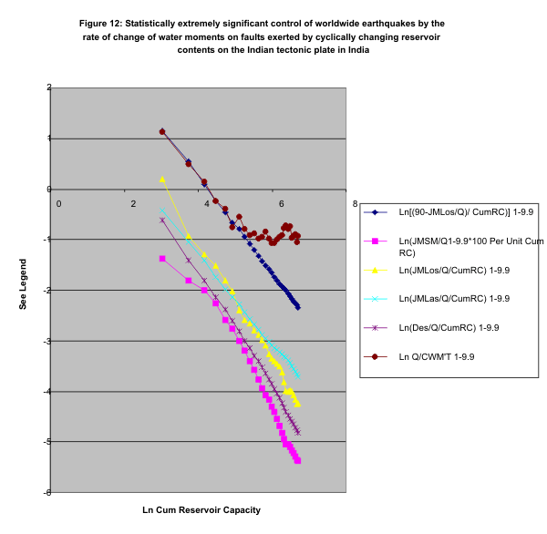
The control of the earthquake parameters by the rate of change of moment is also evidenced in the almost complete explanation of the parameter variances by the logarithmic regression: See Figure 12 and Table 8. There appears to be automatic intrinsic control of earthquakes by the alternating rates of change of water moment.
|
Worldwide Earthquakes: |
1-9.9 |
1-9.9 |
1-9.9 |
1-9.9 |
1-9.9 |
1-9.9 |
|
|
|
|
r(LnCumRC,y)-> |
-0.9980976 |
-0.9973827 |
-0.9998152 |
-0.9980976 |
-0.9838706 |
-0.86893 |
|
|
|
r^2-------------- à |
0.99619888 |
0.99477227 |
0.99963047 |
0.99619888 |
0.96800139 |
0.755041 |
|
|
|
|
Ln(JMLas/ |
Ln(JMLos/ |
Ln(90-Los/ |
Ln(JMDes/ |
LN(%JMSM/ |
Ln |
|
|
RunPeriod |
LnCumRC |
(Q*CumRC) |
(Q*CumRC) |
(Q*CumRC) |
(Q*CumRC) |
(Q*CumRC) |
Q/CWM'T |
|
|
Jun73-May74 |
3.0301337 |
-0.4259825 |
0.19235924 |
1.14285888 |
-0.6151872 |
-1.3841935 |
1.127346 |
|
|
Jun73-May75 |
3.745614167 |
-1.0548194 |
-0.9223968 |
0.54715883 |
-1.4165915 |
-1.8148155 |
0.490976 |
|
|
Jun73-May76 |
4.173556155 |
-1.4045365 |
-1.2834195 |
0.10316873 |
-1.8152169 |
-2.0056488 |
0.143314 |
|
|
Jun73-May77 |
4.483894809 |
-1.7368792 |
-1.5141353 |
-0.228101 |
-2.1440735 |
-2.2620367 |
-0.23827 |
|
|
Jun73-May78 |
4.729853802 |
-1.9876599 |
-1.8172775 |
-0.4588167 |
-2.3831018 |
-2.5937204 |
-0.3975 |
|
|
Jun73-May79 |
4.933876632 |
-2.145403 |
-2.0236962 |
-0.6622246 |
-2.6034578 |
-2.7668705 |
-0.74641 |
|
|
Jun73-May80 |
5.1090437 |
-2.2822788 |
-2.4018899 |
-0.7913764 |
-2.8195714 |
-2.9965881 |
-0.53979 |
|
|
Jun73-May81 |
5.261440704 |
-2.4268097 |
-2.5813662 |
-0.9384502 |
-2.9981808 |
-3.1935568 |
-0.78483 |
|
|
Jun73-May82 |
5.396672905 |
-2.5711602 |
-2.6509788 |
-1.0868867 |
-3.150464 |
-3.3982698 |
-0.90295 |
|
|
Jun73-May83 |
5.51850054 |
-2.6781656 |
-2.7960247 |
-1.2039227 |
-3.2911116 |
-3.5784004 |
-0.8695 |
|
|
Jun73-May84 |
5.629590396 |
-2.7712199 |
-2.8803103 |
-1.3205563 |
-3.4029322 |
-3.7596219 |
-0.97083 |
|
|
Jun73-May85 |
5.731877423 |
-2.877077 |
-2.9907229 |
-1.4211437 |
-3.5276781 |
-3.9406163 |
-0.93652 |
|
|
Jun73-May86 |
5.825333218 |
-2.9437909 |
-3.0914031 |
-1.5131024 |
-3.6505212 |
-4.0716216 |
-0.83232 |
|
|
Jun73-May87 |
5.911417048 |
-3.0292977 |
-3.2573379 |
-1.5834757 |
-3.7604886 |
-4.1692138 |
-0.98658 |
|
|
Jun73-May88 |
5.986233388 |
-3.0922981 |
-3.358905 |
-1.6533544 |
-3.8487665 |
-4.2975488 |
-1.06446 |
|
|
Jun73-May89 |
6.065713581 |
-3.1455092 |
-3.410449 |
-1.7379947 |
-3.9491496 |
-4.4136722 |
-1.05633 |
|
|
Jun73-May90 |
6.135517271 |
-3.1856165 |
-3.4517214 |
-1.8132481 |
-4.0448715 |
-4.5510049 |
-1.00105 |
|
|
Jun73-May91 |
6.201243185 |
-3.2219527 |
-3.5063893 |
-1.8811366 |
-4.1384866 |
-4.6812349 |
-0.94302 |
|
|
Jun73-May92 |
6.263365881 |
-3.2636936 |
-3.6225303 |
-1.9329605 |
-4.2303555 |
-4.8164361 |
-0.91194 |
|
|
Jun73-May93 |
6.322283333 |
-3.3130445 |
-3.8201133 |
-1.9682571 |
-4.3164536 |
-4.9448495 |
-0.7743 |
|
|
Jun73-May94 |
6.378329405 |
-3.3406445 |
-3.9852104 |
-2.0082183 |
-4.4017794 |
-5.0432364 |
-0.71024 |
|
|
Jun73-May95 |
6.431773818 |
-3.3854064 |
-4.0135883 |
-2.0651841 |
-4.4683662 |
-5.0555456 |
-0.78667 |
|
|
Jun73-May96 |
6.482862673 |
-3.4450245 |
-3.9808217 |
-2.1288162 |
-4.5382893 |
-5.1034662 |
-0.73125 |
|
|
Jun73-May97 |
6.531810137 |
-3.5079703 |
-4.0069182 |
-2.1813973 |
-4.5970105 |
-5.1726978 |
-0.95692 |
|
|
Jun73-May98 |
6.578801111 |
-3.5620993 |
-4.0781847 |
-2.2245312 |
-4.6564084 |
-5.2190493 |
-0.92215 |
|
|
Jun73-May99 |
6.624026714 |
-3.6183743 |
-4.1656646 |
-2.2632959 |
-4.720717 |
-5.2962795 |
-0.89939 |
|
|
Jun73-May’00 |
6.667550764 |
-3.6639619 |
-4.2574054 |
-2.2998206 |
-4.7724935 |
-5.3672313 |
-1.05265 |
|
|
Jun73-May'01 |
6.709577474 |
-3.7184573 |
-4.2417285 |
-2.35027 |
-4.8265145 |
-5.3708029 |
-0.9179 |
|
|
Table 8: |
The earthquake response to the cumulative reservoir capacity in tune with the rate of change |
|||||||
|
|
of water moment is almost fully explained by the log -log correlation: The June to May(JM) parameter sum per unit number of earthquakes during the period per unit |
|
||||||
|
|
cumulative reservoir capacity has, in log-log correlation, more than 96% variation explained. |
|||||||
|
|
For number of earthquakes, the ratio per unit cumulative rate of change of water moment correlates in log -log regression with Cum RC with more than 75% of its variation explained by its its r^2. SeeFigure12. |
|||||||
|
|
|
|||||||
|
|
|
|
|
|||||
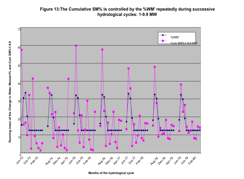
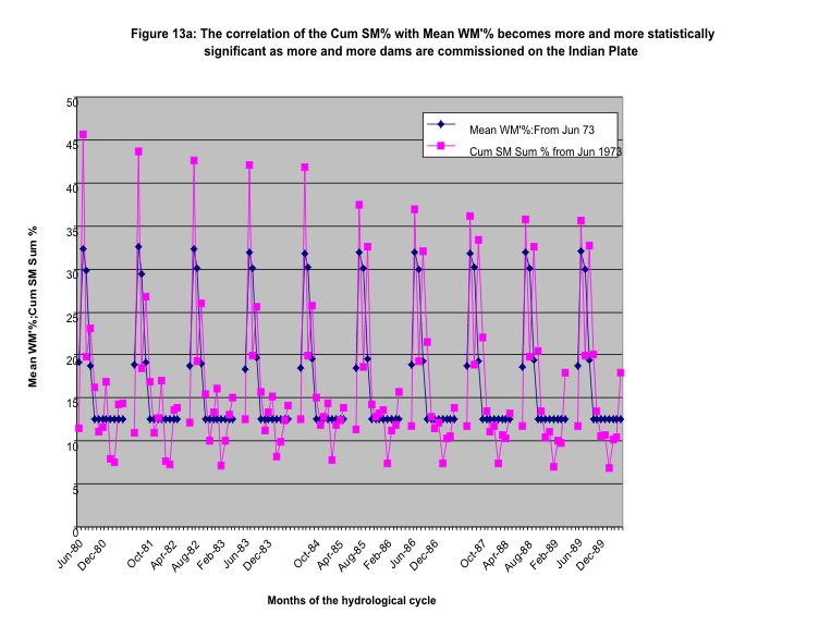
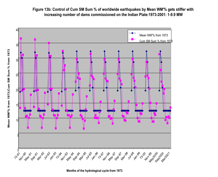
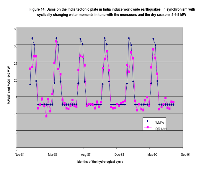
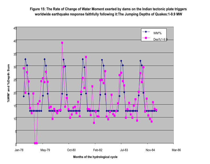
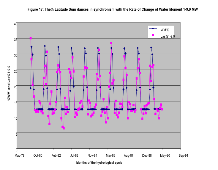
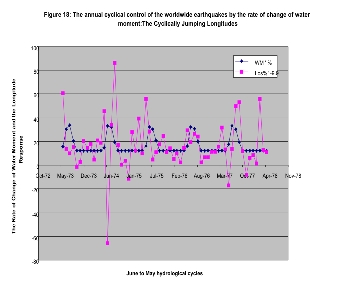
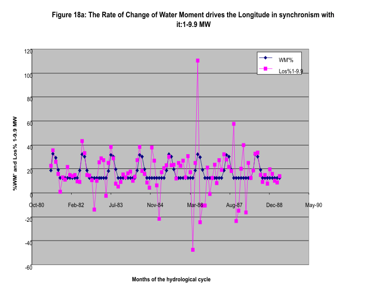
1.4.5 Dance of the Earthquakes in Synchronism with the Hydrological
Cycle becomes tighter with more dams commissioned on the Indian plate: Chaos.
With each annual hydrological cycle, the annual
feature of the earth’s response to the oscillatory rate of change of water
moment is cyclically repeated. See the hold on the earthquake parameters
exercised by the rapidly increasing storages in the monsoon behind Indian dams
on the Indian tectonic plate and the occurrence of the earthquakes during the
dry season when the water moments applied on the faults are released as the
waters are drained from the dams (Figures 13-18a). The control becomes tighter
and tighter as more and more dams are commissioned on the subcontinent of India
as revealed by the closer correlation displayed by the location of earthquakes,
viz., latitude per quake and longitude per quake(compare figures 16,17 and 18
and 18a). Here the earthquake response for 73-78 is compared with that for
79-90 and for 81-88 respectively (the earlier and later periods for comparison
are arbitrarily selected). One also cannot fail to see the closeness with which
the depth sum and the sum of the number of quakes follow the changes in the
water moment, all expressed in percentages of respective wet and dry sums
respectively. Significantly, the seismic moment also displays this
characteristic for the cumulative sums. For quantification of the control with
dam storages, see Figure 1 and Figure 12, Table 1a and Table 8. Also study of
the way the seismic moment ratios follow the water
moment arm ratios( Figures 5,10, 11) and the
ratio of seismic moment to rate of change of water moment for particular
latitude or longitude range follows the ratio for the world(Figures 4,11a, 11b)
brings out a characteristic feature of this observed phenomenon: Chaos. There
is a disturbance pendulum which we recognize here as the rate of change of
water moment. And there
is a response pendulum -the worldwide
earthquakes- characterised by their parameters as discussed above. The response
pendulum, year after year, as the dams on the subcontinent increase, merges
with the disturbing pendulum. The similarity to the responses described in
Sarasola et al(2003) is striking.
The statistical results have established by chi
square analysis that the synchronisation is effectively complete. A giant
experiment in chaos has been unwittingly let loose on the earth by the dams by
their gigantic waves of force and bending moment changes on faults every year.
Figure 13: URL: http://www.geocities.com/rakumra/earthquakescausedbydamsr218.gif
Note that for the figures 14 to 18a the above
URL holds except for the number 218 which changes to 219 to 226 respectively.

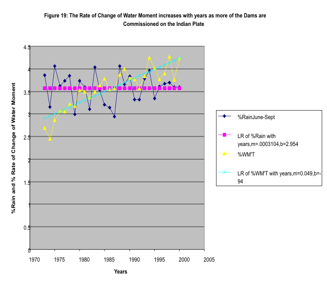
1.5 The Pre-dam Era and the Transition to the
Dam Era
1.5.1 The Results of the Dam Era Tested Against
the Earthquake data of the Pre-dam Era
The whole earth epidemiological evidence of the
dam era is tested against the control group of earthquake parameters of the
pre-dam era(-2150 to 1850) and for the transition period when the dams
increasingly control the earthquakes. This is made possible on the basis of the
assumption that the monsoon rain magnitudes expressed in percent of the total
for the monsoon remain invariant statistically whatever era is being
considered.
The monthly rate of change of water moment is
still given by the monthly rainfall, but the effect is governed by the
rainfall that is harnessed by collecting the waters behind dams as
surface water storage. See Figure 19.
Figure 19: URL: http://www.geocities.com/rakumra/earthquakescausedbydamsr227.gif
 1.5.2
1.5.2
No significant
correlation between Rate of Change of Water Moment and Earthquake Parameters in
the Pre-Dam Era
The data base that is used for the study of the
pre-dam era earthquakes and those that occurred during the transition to the
time when the dams significantly began to influence the quake parameters is the
USGS NEIC data base on significant earthquakes 5.5-9.9 MW between 2150 BC to
the present. The study shows that there is no statistically significant
correlation between the earthquake parameters and the rate of change of water
moment determined as usual for the months of the hydrological cycle June to May
for the period of the pre-dam era 2150 BC to 1850AD and for the dam era till
May 1951. Thereafter the correlation is statistically highly significant. See
Table 9 and Figure 20. The Water Moment Arm Ratio >23 Lat Water Moment
Arm/(Sum of Water Moment Arms) provides a test for the Seismic Moment Sum Ratio
for each of the periods of the pre-dam era as compared to the periods of the
dam era: Figure 21 shows that the two ratios converge to one another in the dam
era circa 1850-1870 and beyond , they diverge into the pre-dam or Paleo Era
1850 to –2000(See the corresponding table:10 for the values). The test for the
convergence of the ratio of the seismic moment to rate of change of water
moment, when applied to the pre-dam era shows a similar result .See Figure 22(details
from Table 10). Interestingly, while the seismic moment ratio >23SM/SMT has
converged to the Water Moment Arm ratio >23WMA/WMT by 1897-1924 itself, the
convergence of the ratio SM/WM’ for >23Lat to the worldwide ratio SMT/WM’T
had to wait till the period1951-1978(Table 10,Chi-square distribution). This
progressively increasing dose-response relationship is statistically highly
significant and raises the discussion of seismic hazard from being a function
of earthquake interaction to what caused the apparent interactions. One
persistent cause that is found from this study is the dam on the Indian plate.
The dose here is the cumulatively increasing dam capacity and the response per
unit dose is the cumulative sum of the earthquake parameter per unit cumulative
number of earthquakes ( Refer to Figure 12 and Table 8).
|
|
|
PRE-DAM ERA |
Transition to |
Effective |
Dam Era |
<---------------- |
DAM-ERA |
--------->> |
|
|
|
|
|
|
5.5-9.9 MW |
5.5-9.9 MW |
5.5-9.9 MW |
5.5-9.9 MW |
5.5-9.9 MW |
5.5-9.9 MW |
1-9.9MW |
|
|
|
|
|
%Significant SM |
%Significant SM |
%Significant SM |
%Significant SM |
%Significant SM |
%Significant SM |
%SM |
|
|
|
Month |
%WM' |
2150BC-1850AD |
1850-1897 |
1897-1924 |
1924-1951 |
1951-1973 |
1973-2001 |
1973-2001 |
|
|
1 |
Jun |
19.18115 |
12.82911503 |
0.462971363 |
38.15522086 |
39.15313935 |
20.87185331 |
33.75405051 |
31.24456 |
|
|
2 |
Jul |
32.18709 |
37.84476361 |
2.609192233 |
11.58204751 |
10.97086717 |
37.02791101 |
25.22974085 |
25.93976 |
|
|
3 |
Aug |
28.57346 |
18.73830645 |
96.11581177 |
28.77306185 |
44.49917571 |
29.51518699 |
21.65180873 |
22.08153 |
|
|
4 |
Sep |
20.05831 |
30.58781491 |
0.812024639 |
21.48966979 |
5.376817778 |
12.58504869 |
19.36439992 |
20.73414 |
|
|
5 |
Oct |
12.5 |
5.76329752 |
9.150805849 |
6.67059375 |
6.771700615 |
5.693346701 |
18.86539812 |
18.20034 |
|
|
6 |
Nov |
12.5 |
47.7276587 |
1.244844619 |
16.72139337 |
17.4965605 |
28.71312609 |
21.30555751 |
19.62906 |
|
|
7 |
Dec |
12.5 |
2.711868358 |
8.035249714 |
14.40041866 |
18.30174808 |
8.96932045 |
8.607216924 |
9.353921 |
|
|
8 |
Jan |
12.5 |
0.806352035 |
12.96911401 |
27.80694675 |
7.762298905 |
6.629785936 |
9.159941212 |
10.35381 |
|
|
9 |
Feb |
12.5 |
7.79370835 |
11.63205653 |
6.577777401 |
7.617405162 |
6.507724876 |
7.889671167 |
8.329705 |
|
|
10 |
Mar |
12.5 |
31.76235247 |
17.65880489 |
3.87439616 |
24.83241348 |
28.98478242 |
10.35327841 |
10.53751 |
|
|
11 |
Apr |
12.5 |
1.288556507 |
21.21654378 |
15.03763942 |
5.412822788 |
2.829582519 |
9.813891458 |
10.10059 |
|
|
12 |
May |
12.5 |
2.146206057 |
18.09258061 |
8.910834483 |
11.80505047 |
11.672331 |
14.0050452 |
13.49507 |
|
|
|
r |
(%WM',y) |
0.420360106 |
0.385072433 |
0.339124442 |
0.393238715 |
0.669767715 |
0.616720358 |
0.693934 |
|
|
|
p[r] |
|
0.173636053 |
0.216427836 |
0.28087183 |
0.206008219 |
0.017183906 |
0.032682671 |
0.012301 |
|
|
|
Table 9 There is no statistically significant correlation between the percent rate of change of water moment and the percent seismic moment for significant earthquakes of 5.5-9.9 MW for the Pre-Dam Era. The rate of change of water moment exerts significant control over earthquakes from 1951onward. |
|||||||||
|
|
|
|
|
|
|
|
|
|
|
|
|
|
|
1 |
2 |
3 |
4 |
5 |
6 |
7 |
8 |
|
|
Era |
<-------Pre- Dam Era--> |
<---------------------------------Dam Era------------------------------ |
------>---> |
|
|||||
|
Period June-May |
-2000-1000 |
1000-1870 |
1870-1897 |
1897-1924 |
1924-1951 |
1951-1978 |
1951-2003 |
1978-2003 |
|
|
WMAT |
10.35 |
8.2 |
7 |
7.7 |
8 |
8 |
9 |
8.9 |
|
|
WMA>23 |
2.35 |
4.6 |
3.2 |
4 |
4 |
4 |
5 |
4.154 |
|
|
WMA/WMAT%=E |
22.705314 |
56.097561 |
45.714286 |
51.948052 |
50 |
50 |
55.5555556 |
46.674157 |
|
|
SMT |
2237.8 |
110247.82 |
3527.8 |
39629.8 |
21724.5 |
12631.5 |
23472.4451 |
10841.045 |
|
|
SM>23 called SM |
2237.8 |
8913.42 |
2253 |
19419.7 |
8430.2 |
7749.5 |
12385.7325 |
4646.03 |
|
|
SM/SMT%=O |
100 |
8.08489456 |
63.864165 |
49.002771 |
38.805036 |
61.350592 |
52.7671169 |
42.855924 |
|
|
SM/SMT%-WMA/WMAT% |
77.294686 |
-48.012666 |
18.149879 |
-2.945281 |
-11.19496 |
11.350592 |
6.09295957 |
-12.69963 |
|
|
(SM/SMT)/(WM'/WM'T) |
4.40425532 |
0.14412203 |
1.3970286 |
0.9433033 |
0.7761007 |
1.2270118 |
1.13054247 |
0.7714066 |
|
|
SM/WMA |
952.255319 |
1937.7 |
704.0625 |
4854.925 |
2107.55 |
1937.375 |
2981.64 |
929.206 |
|
|
SMT/WMAT |
216.21256 |
13444.8561 |
503.97143 |
5146.7273 |
2715.5625 |
1578.9375 |
2637.35338 |
1204.5606 |
|
|
WM'>23 |
5.8127E-11 |
210.848017 |
663.5722 |
2976.8141 |
6713.6374 |
15733.571 |
47103.6198 |
25637.69 |
|
|
WM'T |
2.5601E-10 |
375.859509 |
1451.5642 |
5730.3671 |
13427.275 |
31467.142 |
84786.5156 |
54929.09 |
|
|
>23SM/WM' % =O1 |
3.8498E+15 |
4227.41466 |
339.52598 |
652.36523 |
125.5683 |
49.254552 |
26.2946512 |
18.121875 |
|
|
SMT/WM' T % =E1 |
8.7411E+14 |
29332.1886 |
243.03438 |
691.57524 |
161.79381 |
40.141872 |
27.6841723 |
19.736437 |
|
|
(O-E)^2/E |
263.130846 |
41.0929833 |
7.206021 |
0.1669876 |
2.5065445 |
2.5767187 |
0.13995702 |
0.3123551 |
|
|
X^2 |
317.132413 |
54.0015672 |
12.908584 |
5.7025629 |
5.5355752 |
3.0290308 |
0.45231208 |
0.3123551 |
|
|
df |
7 |
6 |
5 |
4 |
3 |
2 |
1 |
0 |
|
|
p(X^2) |
1.3225E-64 |
7.3718E-10 |
0.0242507 |
0.2224895 |
0.1365262 |
0.2199147 |
0.50123903 |
|
|
|
%p(X^2) |
1.3225E-62 |
7.3718E-08 |
2.4250663 |
22.248947 |
13.652623 |
21.991473 |
50.1239025 |
|
|
|
(O1-E1)^2/E1 |
1.013E+16 |
21486.6229 |
38.309925 |
2.2230768 |
8.1108678 |
2.0686862 |
0.0697427 |
0.1320811 |
|
|
X^2(1) |
1.013E+16 |
21537.5372 |
50.91438 |
12.604455 |
10.381378 |
2.2705101 |
0.20182384 |
0.1320811 |
|
|
p(X^2)(1) |
0 |
0 |
9.005E-10 |
0.0133793 |
0.0155876 |
0.3213402 |
0.65325271 |
|
|
|
%p(X^2)(1) |
0 |
0 |
9.005E-08 |
1.3379281 |
1.5587552 |
32.134016 |
65.3252707 |
|
|
|
Table 10 |
Significant Quakes 5.5-9.9 MW:2150BC-2003AD:SM Ratio and WM Arm Ratio |
|
|
||||||
|
|
converge to one another in dam era while they diverge into the pre-dam era. |
|
|
||||||
|
|
Similarly with the ratios >23SM/WM' and SMT/WM'T. Note that the convergence trajectory for the latter set leads to the stress relief ratio in rocks of 19.743% from the begin of the dam era. See Figure 22. |
|
|
||||||
|
|
|
|
|||||||
|
|
|
|
|
|
|
|
|
Figure 20:URL: http://www.geocities.com/rakumra/earthquakescausedbydamsr228
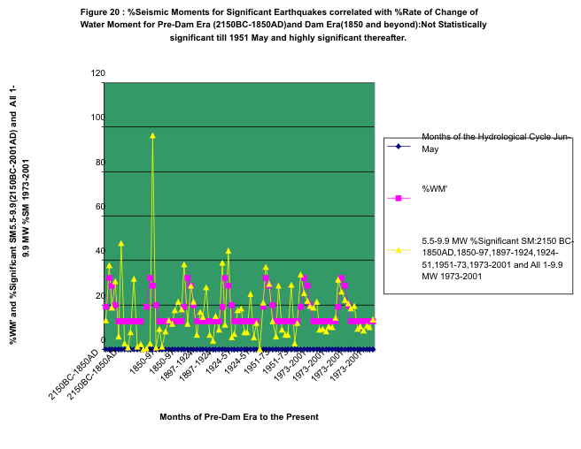
Figure 21: URL: http://www.geocities.com/rakumra/earthquakescausedbydamsr229.gif
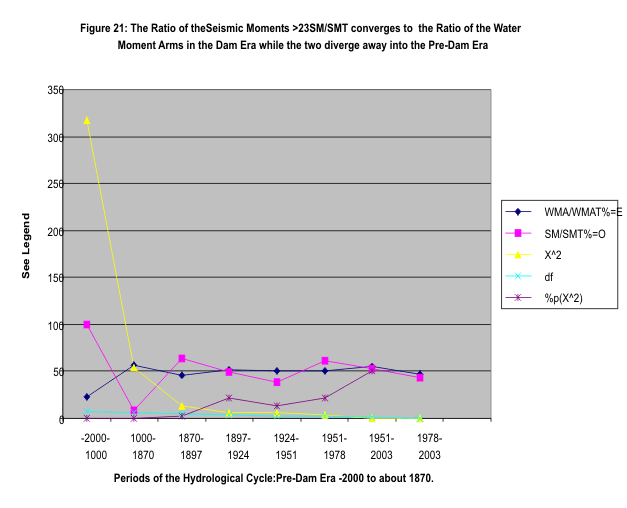
Figure 22: URL: http://www.geocities.com/rakumra/earthquakescausedbydamsr230.gif

2.0 Conclusion.
Whole-earth epidemiological evidence is
presented above for the hypothesis that dams on the Indian plate are causing
worldwide earthquakes persistently, in tune with the hydrological cycle of the
monsoon followed by the dry season water withdrawal. With rapidly increasing
number of dams on the subcontinent the correlation of worldwide annually
recurring earthquakes with increasing surface water storage changes in a fixed
time span has become progressively stronger by the application of rapidly
rising moments on faults during the monsoon and their release during the dry
season by water withdrawal from dams. As one passes from the pre-dam era to the
present the complete absence of correlation with the water moment changes is
replaced by striking cause effect relationships as stated. A frightening result
is that the effects pendulum of waves of earthquakes has effectively
synchronised with the cause pendulum of gigantic waves of force and of changing
bending moments on faults . The annual destruction of life and property is
heartrendingly described in the Statistics on Significant Worldwide Earthquakes
in the range 5.5-9.9 MW in the Earthquake Database of USGS. The irreversible
losses due to this man-made avoidable cause require urgent palliative action
and probably some more drastic action such as dismantling dangerous dams.
3.0 Acknowledgments
The author thanks adversarial reviewers of an early version of the
manuscript for their comments. Also the author wishes to place on record the
data base providers for the useful sources referred to in this work.
4.0 References and Notes:
1.Cartographic Division,National Geographic Society.,1995. The
Earth’s Fractured Surface. 2D Tectonic Map of the World . National
Geographic Magazine. April 1995.Reference for Figure 3.1 of this paper.
2. Earthquake data from USGS website: http://wwwneic.cr.usgs.gov/neis/epic/epic.html
3. Heimpel M.,1997. Critical Behaviour and the Evolution of Fault
Strength during Earthquake Cycles. Nature. Vol.338.28th August. pp
865-868.
4. Kingsley Davis.1951., Table 6. Estimation of Indian
Population,300 B.C to 1871 AD. In The Population of India and Pakistan.
New York. Russel and Russel.
5.National Geographic Society., 1997. May 1997. Map: South Asia.National
Geographic Magazine.
6. Rainfall data from:
http://ingrid.Ldgo.columbia.edu/Sources/Indices/.india/.rainfall/
7.Sarasola C., Torrealdea F. J., D’ Anjou A., Moujahid A., Grana
M., 2003. Feedback Synchronisation of Chaotic Systems. International Journal
of Bifurcation and Chaos, Vol. 13, No.1, 177-191.
8. Statistical Outline of India.,1998-99. Tata Services Ltd.Dept.
of Economics and Statistics. Bombay House. Mumbai-400001. For Irrigation
Potential Created by Large and Medium Sized Projects. Table 58. 1993-94 and for
1996-97. For other years the same source for those years. For
certain years when data was unavailable, they were extrapolated
from available data using compound interest formula.
9.
Stein R. S., 1999. The Role of Stress Transfer In Earthquake Occurrence. Nature.Vol.402.9th
December. p 60910. Toda S., Stein R. S., Sagiya T., 2002. Evidence from the AD
2000 Izu islands earthquake swarm that stressing rate governs seismicity.
Nature.Vol.419. 5 September. Figure 5.
11.
TanimotoT., State of Stress within a bending spherical shell and its
implications for subducting lithosphere.Geophys. J. Int.(1998) 134,
199-206 12. Turcotte, D.L., and Schubert,G., 2002 .
Chap.8.Faulting: Earthquakes. in Geodynamics . p 353.2nd Ed.Cambridge
University Press.UK
.
Appendix A
Centre Of Gravity Of Stored Water Behind Dams
A map of India was taken on a suitable scale , in this case it was 1
inch = 116 miles(Ref. 5). The distances of the water bodies from Bhuj were
measured and inserted into the equations :
X = Sum(Si* Xi)/Sum Si
-----------------------------------------------------(1)
Y = Sum (Si *Yi)/Sum Si
------------------------------------------------------(2)
Where
Si = Storage of dams in state i , assumed to be located at the
centre of the state ;
Xi,Yi are the x and y coordinates of the water bodies of state i
from the origin taken to be Bhuj arbitrarily, and
X and Y are the coordinates of the centre of gravity of stored water
behind all the dams in all the states.
Thus the centre of gravity, CG , has latitude and longitude as given
by:
Latitude of CG = Latitude of Bhuj + Y
-----------------------------------(3)
Longitude of CG= Longitude of Bhuj + X
--------------------------------(4)
Referring to Table 58 of reference 8 for the year 1998-99, we read
off the total irrigation potential(IP) created up to 1993-94 for Major and
Medium dams for the various states(a measure of the dam storages) and enter
them into equations 1 and 2 above and also into them the x and y coordinates
from the origin- Bhuj, for the water bodies for each state as read off from the
map :
We tabulate in the form of a table for convenience (Table A)
Thus
the x and y values in equations 1 and 2 above are
x=12.5
and y= -0.6
Thus from equations (3) and (4), with appropriate readings from the
map referred to above, the Latitude of CG becomes
Latitude
of Bhuj + ‘y’= 23
And
the longitude of CG becomes
Longitude
of Bhuj + ‘x’ = 78.75
Reference Map: National Geographic Society .1997. National
Geographic Magazine. May 1997: Map:South Asia: Data from Ref 8,this paper.
|
Table A: |
To Determine the Coordinates of the Centre of Gravity of Water Masses behind Dams in India |
|||||
|
|
as of |
1994 AD |
|
|
|
|
|
S.No. |
State |
Irrigation |
Distance x from Bhuj |
(IP)I *(Xi) |
Distance y |
(IP)I * (Yi) |
|
|
|
Potential |
in |
|
from Bhuj |
|
|
|
|
(IP),mHa |
centimetres |
mHa-cm |
in cm |
mHa-cm |
|
1 |
Andhra |
|
|
|
|
|
|
|
Pradesh |
3.1 |
12.5 |
38.75 |
-9 |
-27.9 |
|
2 |
Assam |
0.2 |
30.5 |
6.1 |
5 |
1 |
|
3 |
Bihar |
2.8 |
23 |
64.4 |
0 |
0 |
|
4 |
Gujarat |
1.4 |
2 |
2.8 |
-2 |
-2.8 |
|
5 |
Haryana |
2.1 |
9 |
18.9 |
10 |
21 |
|
6 |
Jammu,Kr |
0.2 |
9 |
1.8 |
17 |
3.4 |
|
7 |
Karnataka |
1.5 |
6.5 |
9.75 |
-12 |
-18 |
|
8 |
Kerala |
0.6 |
10 |
6 |
-23 |
-13.8 |
|
9 |
Madhya Ph |
2.1 |
6 |
12.6 |
-2.5 |
-5.25 |
|
10 |
Maharashtra |
2.2 |
6 |
13.2 |
-8.5 |
-18.7 |
|
11 |
Orissa |
1.5 |
22 |
33 |
-6 |
-9 |
|
12 |
Punjab |
2.4 |
9 |
21.6 |
13 |
31.2 |
|
13 |
Rajasthan |
2.1 |
8 |
16.8 |
3 |
6.3 |
|
14 |
Tamilnadu |
1.5 |
12 |
18 |
-19 |
-28.5 |
|
15 |
Uttar Prad |
7 |
15 |
105 |
6 |
42 |
|
16 |
West Bengal |
1.3 |
25 |
32.5 |
0 |
0 |
|
17 |
Sum1-16 |
32.1 |
|
401.2 |
|
-19.05 |
|
|
|
|
|
12.49844 |
|
-0.593457944 |
|
|
|
|
|
say 12.5 |
|
say -0.6 |
END OF PAPER-R. ASHOK KUMAR-EARTHQUAKES CAUSED BY DAMS-JULY 2004


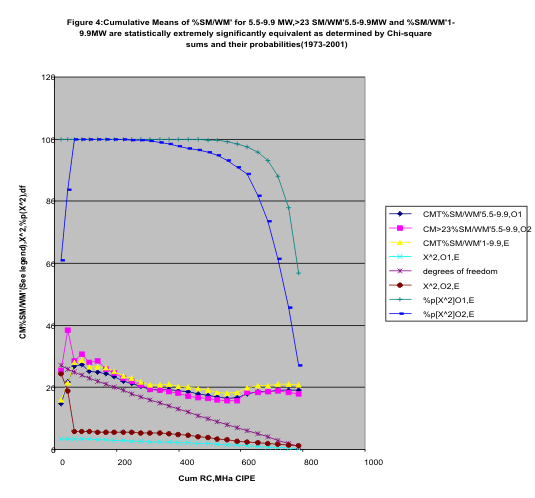
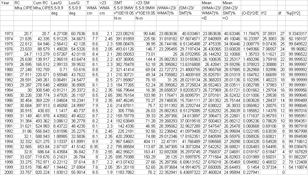