13 June 2004
This flight went a bit closer to how it was intended - at least the "mission" was completed.
The trip was planned to attend the Cobden fly-in, conducted by the Champlain Flying Club. The club recently became a local chapter of COPA (COPA Flight 124) and my job was to present them with their certificate. Unlike the Smith Falls Fly-in last weekend I decided that I had better do this flight with ground support. So to that end I asked Ruth to drive our truck and carry the overnight camping equipment, while I brought the plane up. Our plan was to come up in the calmer evening air the night before, camp overnight and then present the certificate in the morning, have breakfast and depart before the day got too rough.
The weather for Saturday night looked really good in the forecasts - it should be clear and calm. We packed up our equipment and went out to the Carp airport to get the plane ready. I wanted to wait until the evening convection had died out to make for a smoother flight. The trip was 38 nm (44 sm) direct line distance, although I planned to follow the highway for most of the route, keeping fields within range. The weather for Sunday was not forecast to be as good with a weather system moving in, in the afternoon. The winds aloft forecast showed south-westerly winds starting at 0200 hrs local at 3000 feet of 230 degrees at 22 knots, while the surface forecasts all showed calm until 0900 hrs local. Not a good scenario. By afternoon the winds were supposed to be gusty and the sky clouding over with showers forming.
I took-off once the wind had died out at Carp, at about 1745. It was soon apparent that the day's thermals were still present, if in a weakened state. It was still a bit bumpy, but manageable. I picked up an increasing tailwind as I travelled enroute. My indicated airspeed was 45 mph (using the new bungee trim system) which produced a TAS of about 40 knots (yeah, I know, "mixed units" here, but the plane's ASI is in mph, whereas all air navigation in Canada is done in knots and nm). My route to avoid unlandable terrain probably took my over a distance of about 43 nm or so and the trip lasted 1.0 hrs in the air for an average groundspeed of about 43 knots. The tailwind and turbulence increased as I got closer to CPF4 Cobden.
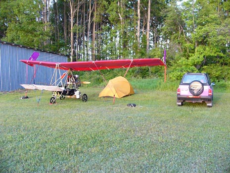
On arrival there was no one there - I had even beaten Ruth there driving the truck! The windsock was showing about 6-7 knots right down the smooth grass surface of runway 12. I completed an overhead join to downwind. As I turned final my groundspeed dropped to 30 knots indicating a good ten knot wind near the surface. The approach to runway 12 at CPF4 brought me in over two lines of tress and there were definite bumps as I passed over each one. I just carried extra speed, leaving the trim on set for 45 mph. I held the power on into the flair and as soon as I pulled the throttle back the Ascender settled onto the runway coming to a stop on its own in about 200 feet or less. I had to add power to taxi, turning off onto the freshly cut grass taxiways.
CPF4 is a beautiful aerodrome - just the kind of place that almost every recreational flier wishes to fly from. The club had everything all set up for the next day's fly-in; tables, chairs, everything was perfect, just no one home! I taxied to the back of the hangar row, where I had been told there would be a tie-down spot. As I turned down the hangar row the wind became a tailwind and the plane picked up speed. The brake wasn't very useful on the grass, so I shut down the engine and coasted with the wind to the spot.
The flight was 1.2 hours on the Hobbs meter, with 1.0 hrs in the air. That makes all the calculations really easy! The plane burned 10 litres of fuel or 2.6 US gal/hr. I had flown it at 5000 rpm whereas previous cruising had been done at 4500 rpm (before the trim system was installed) where it had burned 2.4 US gal/hr.
Ruth soon showed up with the truck and we pitched our tent in the park-like setting of the airfield. The night's sleep turned out to be less than ideal because the airfield is mere yards away from the Trans-Canada Highway and it has lots of heavy truck traffic all night. Now if only that airfield was a mile further from the highway it would be a great fly-camping destination!
We took a few minutes in the evening to drive into town (now that is the advantage of ground support - thank you Ruth for bringing the truck!) get some supper and buy some fuel for the plane.
In the morning the fly-in started early, with the first of the club members showing up at 0530 hrs!!! Now that is dedication. By 0700 they had breakfast cooking. The early morning was gorgeous, with a slight southerly wind filling in - a portent of the later day weather that was in the forecast.
We sat down and had breakfast - lots of eggs, sausages, pancakes, ham, toast, orange juice, etc. This club really does a big fly-in breakfast!
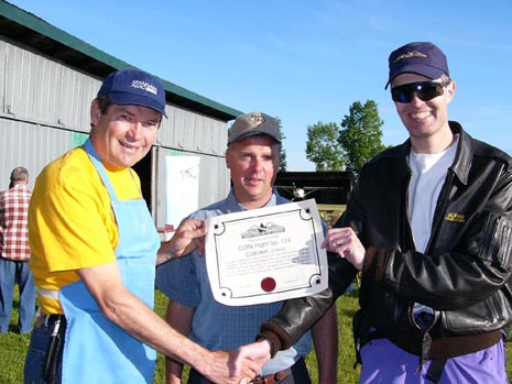
Next we had the COPA Flight certificate presentation to do. We found club President Larry Buchanan resplendent in his breakfast cooking apron and he rounded up Ray Nash for the photo. Ruth snapped the picture.
The wind was beginning to stir so I thought I had better get going before the colder air aloft from the incoming system found its way down to the ground. We packed up the tent and sleeping bags, preflighted the Ascender and stowed the covers and control locks. Starting was hard as the engine refused to catch. It took about 30 attempts to get it going - that left me pretty tired even before the start of the leg home.
Once I got the plane going it was a quick job to get to the runway. Lots of people there wanted to see the Ascender perform and the five knot headwind down the runway made the takeoff very short with a steep climb out. I immediately set course for Carp, levelling out at just over 1000 ft AGL. I trimmed for 45 mph and the air wasn't too rough. Within a few miles south the air started getting rougher and rougher until it was obvious that I had to find a smoother level. It was like being in a mixer. A short climb showed that it was worse aloft as the system air was mixing down. So I descended. Around 700 ft AGL it was a bit smoother and so I cruised towards Arnprior at that height. The groundspeed settled down at about 30 knots which isn't too bad for the Ascender, indicating about ten knots on the nose.
Pretty soon it was getting rough at 700 AGL, even though the surface still showed no wind at all. I descended down to 500 ft AGL and stayed clear of built up areas. Soon I could see that the winds were gusting on the surface as swimming pools and ponds showed waves. The trees were moving a lot, too. It was pretty rough at 500 feet with constant adjustments to maintain altitude. The groundspeed held on and even increased a bit to 35 knots as the wind seemed to swing around to become more south-westerly. There was no better level, so I just fought the turbulence, levelling the plane constantly and flew onto get home before it got worse yet.
I skirted around the Arnprior area to the south and headed into Carp, joining overhead for a close circuit to the grass infield into the wind. The surface winds were that "unpredictable 5 knots gusting to 15", with quick changes in wind direction. Just as I got into the flare a gust rapidly decreased and backed, leaving me with a quick loss of 15 mph in airspeed. I managed to give it a bit of throttle and flared to touchdown with almost zero speed. Moving from the grass on to the taxiway into the wind required some power to get going, but once I turned the corner into the hangar line the wind was behind me and so I killed the engine and rolled the 200 yards to stop in front of the hangar. Whew!
That leg put 1.4 hours on the Hobbs meter and took 1.2 in the air. The fuel burned was 12 litres, for a consistent 10 litres per hour (2.6 US gal/hr) again. Over all the out-and-back took 2.2 in the air and 2.6 on the Hobbs meter. It burned 22 litres of fuel and the average groundspeed was about 38 knots on the actual route flown. Not too bad overall. We did fuel up in Cobden, but I could have made the round trip of 76 nm without refuelling. If I had had a full load of fuel leaving Carp I would have landed back there with 12 litres or about 1.2 hours remaining.
This was my first successful cross-country flight and a good contrast to the flight last weekend where I didn't get to Smiths Falls. Overall it went well enough and I have learned a lot more about how to fly this plane cross-country. The basic downside to the flight was the rough air on the trip home - it was survivable, but not a lot of fun to be up in!
In the last two weekends I have learned a lot about what it takes to fly this plane distances. I have gained a real appreciation for what the early cross-country ultralight fliers, like Jack Petersen, went through in completing their epic journeys and why they stand as real accomplishments.
I am also learning why a number of the Pterodactyl Club members have mentioned that they don't fly their Pterodactyls cross country at all. The main issue is not getting there, as you can pick the right day to do that, it is getting back. Jack Petersen, flew downwind the whole way from California to South Carolina and he then donated his Pfledge to the Smithsonian! I guess that saves having to worry about the upwind flight back home!
I have also learned why a lot of long distance Pterodactyl flights seem to have low average daily travel times. Peterson averaged about 96 nm per day on his 1979 Pfledge flight. Jack McCornack and Keith Nicely averaged about 57 nm per day on their Pfledge flight to Oshkosh and Kitty Hawk, NC in 1979, although they were touring and in no hurry. On their Ascender II+2 flight to Mexico in 1982 Jack McCornack and Robin Sclair averaged 127 nm per day. I think the reason is that these pilots carefully picked the times of day to fly in to minimize rough air and other poor conditions.
I still have a lot to learn about flying the Ascender distances, but I am getting there. It would be easier if I could find smoother days to do it in!