Mt Maroon
Maroon - conventional route
(Red line on photo)
For most people Maroon is experienced by parking just off Cotswald Rd near a dam. Cotswald Rd joins Boonah Rathdowney Rd about 10km further on than the Mt Barney turnoff from Rathdowney. The route is well marked and follows the North East ridge of Mt Maroon for two thirds of the ascent. The track then traverses and descends slightly west (to avoid a tricky exposed section) and into a dry gully. The gully is ascended to the high Maroon plateau. The main summit of Maroon is found by following a well used track south and slightly east. A rocky outcrop on the east needs to be ascended towards the summit. As it is clearly visible there are no navigational issues. A big cairn marks the summit with 360 degree views. 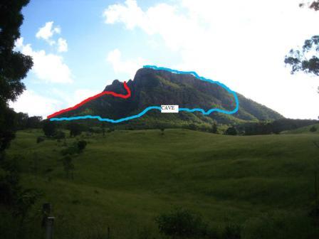
Maroon - North West Ridge
(blue line on photo)
Instead of ascending up the North East Ridge find a track that is less well used just a few metres beyond leaving the clearings about 5 minutes walk from the cars. Follow this track west until at least two gulleys are crossed and then ascend to the base of the cliff line. Following this around leads to a huge cave which is great for a view, chat and drink stop. Descend to the base of the cliff and move around the mountain at this level until Mt May almost becomes visible (or until it does become visible to be safest) and then ascend. There are some nice boldering experiences up here and eventually when you reach the rocky slabs at the top, follow them East above the huge cliffs to get great views and the breezes generated by thermals here. This can be followed along until rejoining the main conventional route, 10 - 15 minutes before the summit.
Maroon from the South
Another terrific route is to ascend the South Ridge. The road to Lower Portals divides and you need to take the right hand branch. I find parking near Drynans hut the best place to begin. Take a bearing north to Mt Maroon. You will see a cliffline and ridge descending from the east. Head west a little to make it easy to ascend this and follow it all the way up. It has great views and easy scrambling (lots of it) all the way to the summit. A good way to descend is to follow the second creek downstream to Paddys Plains camp site and follow Paddy's gully back to the car.