![[Robinson Cousin Homestead logo]](../images/Robinson_barn_small_washout_text_6.jpg)
|
|
|
Historical
Notes and Brief Biographies
Attakullakulla—c.1700/1712- c.1782, according to his son Turtle-at-Home, a Mishawaka Nippising captive from the Great Lakes, adopted into the family of Moytoy (a Cherokee chieftain who gave his allegiance to King George II and was accepted as "Emperor" by the Cherokee), known to the English as the Little Carpenter. Intelligent and eloquent, he dominated Cherokee dealings with the white settlers and treaty makers for nearly fifty years (including the Transylvania Company representatives in the Sycamore Shoals treaty). He also used his exceptional speaking skill to discourage Cherokee alignment with the French. Attakullakulla was the youngest of a seven-man Cherokee delegation to visit London in 1730. Bartram describes him as "A man of remarkably small stature, slender and of a delicate frame, the only instance I saw in the Nation; but he is a man of superior abilities." Father of Dragging Canoe and uncle of Nancy Ward, Beloved Woman of the Cherokee. Attakullakulla once said, "Some of the warriors of my nation, upon hearing stories true or false are immediately in a flame, but that is not my way—I love calmness and moderation." Carteret,
Sir George, Earl of Granville—In
1663, England's King Charles II granted eight of his advisors all the
New World land lying to the south of Virginia and north of Florida,
and extending west to the Pacific Ocean. Among them was Sir George Carteret,
afterwards Earl of Granville. These Lords Proprietors named the land
Carolina in the king's honor and began colonization attempts in order
to increase the value of their holdings. The Proprietors proved unpopular
with the colonials and by 1729 seven of the eight Proprietors had sold
their rights to Carolina back to the English crown. Only Lord Granville
saw fit to retain his holdings, which was given him in land in 1743,
though he had to give up his share in the government of the colony.
Hence grants from Granville are as valid as those from the Crown. Granville's
land included most of the upper half of North Carolina, encompassing
thepresent day cities of Raleigh, Durham, Greensboro, Winston Salem,
and Asheville. He collected rents from it until 1776, his dishonest
agents giving the settlers on it great trouble. Corn Tassel—(Old Tassel, Koatohee) Cherokee leader, treaty signer, and proponent of peaceful relations with the encroaching white settlers. He was executed in Georgia for murder of another Cherokee while awaiting Supreme Court decision to determine sovereignty of the Cherokee Nation in the matter. This action by the government of Georgia, refusing to acknowledge the Cherokee Nation was backed by President Jackson, who insisted no independent nation could exist within the U.S. In 1838, this attitude culminated in the Indian Removal known as the "Trail of Tears." His eloquent speech to the U. S. Congress, 1785:
Dragging Canoe—1732-1792, son of Attakullakulla, cousin of Nancy Ward. Dragging Canoe, who survived smallpox in 1739, rebelled against his father and the elder chiefs and became a leading force in the Cherokee's resistance to white settlement on Cherokee lands. At the conclusion of the Treaty of Sycamore Shoals of 1775, Dragging Canoe spoke against the sale of Cherokee land:
When Richard Henderson, hoping to gain safe pathways through Cherokee lands, asked to "buy a road, " Dragging Canoe gave the prophecy which was to echo throughout white settlements for decades"
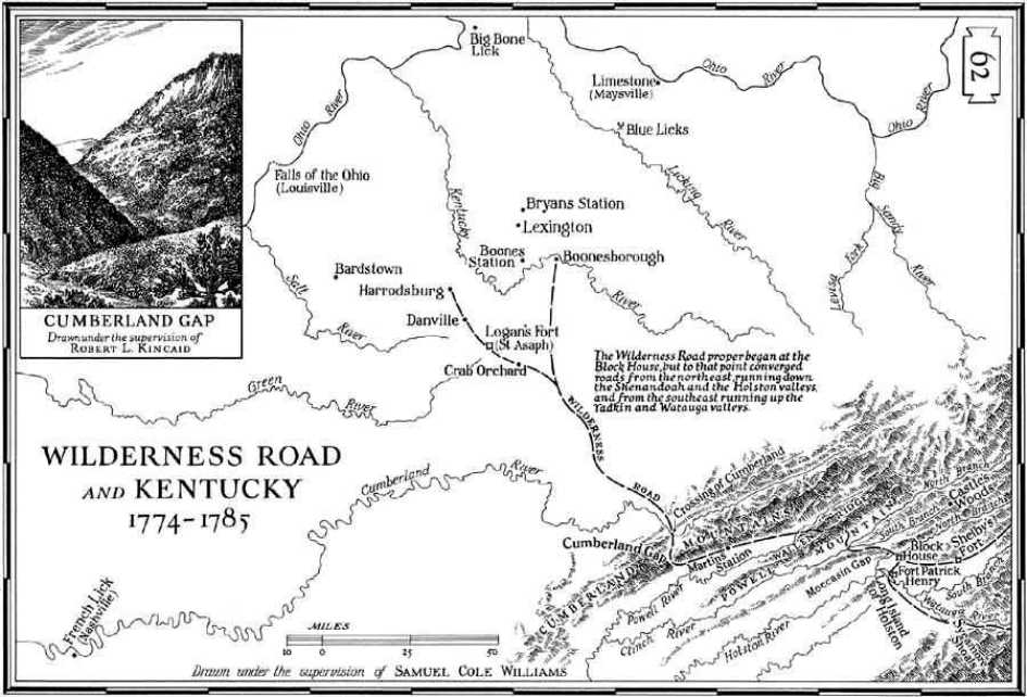
He eventually withdrew from the Cherokee nation because of his opposition to further land cessions; he and his followers formed the Chickamauga Towns and continued the struggle against white intrusion. Fort Robinson —In 1756, the South Carolina colony built Fort Loudon in the far reaches of the western wilderness in order to resist the French (see French and Indian War). Over the next few years, relations between South Carolina and the Cherokee Nation broke down, and in 1760, the garrison at Fort Loudon was overthrown by the Cherokees. South Carolina then sought help from Virginia, whose Governor Fauquier directed Colonel William Bird III to erect a fort at the Long Island of the Holston from which the English could continue negotiations with the Cherokee as well as protect their trade and land from the French. Colonel Bird attempted to build a road to the fort site but only reached as far as Chilhowie, Virginia. Colonel Adam Stephen succeeded Bird as commander of the military unit assigned to the task which included such men as Dr. Thomas Walker, Major Andrew Lewis, Nathaniel Gist, Gilbert Christian, Henry Timberlake and Thomas Sumpter. In 1761, Major Andrew Lewis, who headed three companies of experienced woodsmen, built the Island Road, which followed old Indian trails, and progressed from water spring to water spring. The wagon road was completed by September, and Colonel Stephen's militia marched down to Long Island where they built Fort Robinson, the second English fort in what is now Tennessee. Henry Timberlake states in his memoirs, published in London in 1765:
The pioneer
fort initially failed, but was reoccupied from 1770-1776. It was located
on the south fork of the Holston River, near the area known as Island
Flats. Cherokees attacked the fort in 1776 but were defeated by the
settlers; this began the Cherokee War of 1776. Fort Patrick Henry was
built at or near the site in 1776, and was used by more than 200,000
settlers between 1775 and 1795. Later, the area was briefly called Christianville,
named for an early settler, Gilbert Christian. Today the area is called
Kingport, named in 1822 for William King who came from Washington Co.,
VA to found King's Boat Yard in the early 1800s. Flatboats loaded with
salt and other products from his port could travel the rivers, trading
goods all the way to New Orleans. The Long
Island in the middle of the river was sacred to the Cherokee, and today
a Cherokee Memorial stands on the island. Long Island was also the starting
point for the Wilderness
Road blazed by Daniel Boone through Moccasin Gap and Cumberland
Gap to Kentucky. Though not
long-lived, Fort Robinson was a spearhead —an opening of the way
for the settlement of the western frontier. French and Indian Wars—1689-1763, the name given by American historians to the North American colonial wars between Great Britain and France in the late 17th and the 18th cent. They were really campaigns in the worldwide struggle for empire and were roughly linked to wars of the European coalitions. At the time they were viewed in Europe as only an unimportant aspect of the struggle, and, although the stakes were Canada, the American West, and the West Indies, the fortunes of war in Europe had more effect in determining the winner than the fighting in the disputed territory itself. To the settlers in America, however, the rivalry of the two powers was of immediate concern, for the fighting meant not only raids by the French or the British but also the horrors of tribal border warfare. The conflict may be looked on, from the American viewpoint, as a single war with interruptions. The ultimate aim —domination of the eastern part of the continent —was the same; and the methods —capture of the seaboard strongholds and the little Western forts and attacks on frontier settlements —were the same. The wars helped to bring about important changes in the British colonies. In addition to the fact of their ocean-wide distance from the mother country, the colonies felt themselves less dependent militarily on the British by the end of the wars; they became most concerned with their own problems and put greater value on their own institutions. In other words, they began to think of themselves as American rather than British. —From Encyclopedia.co Gardoqui, Diego de—Agent for the King of Spain to the American government; and Miro, Estevan—Governor of Spanish Louisiana. During the late 1700s, both were involved in schemes to alienate western settlers from the U.S. government. At that time, Spain was in possession of the Louisiana Territory. Gardoqui and Miro's goal of expanding Spanish territory into areas settled by Americans loyal to Spain ended with the United States' purchase of the Louisiana Territory in December 1802. Harrod, James—1742-1793, American frontiersman, b. Bedford co., Pa. He fought in the French and Indian Wars and in 1773 made a journey down the Ohio River to Kentucky. In 1774 he returned to Kentucky and began a settlement, the first in the state; it was named Harrodsburg in his honor. Later he opposed the colonization schemes of Richard Henderson and his Transylvania Company. In 1777, 1779, and 1782 he took part in campaigns against native tribes and was a member of the Virginia assembly (1779). Harrod disappeared mysteriously while trapping with two companions and never returned. He probably was murdered. —From The Columbia Encyclopedia, Sixth Edition, 2001 Henderson, Richard —1735-85, American colonizer in Kentucky, b. Hanover co., Va. An associate justice of the North Carolina superior court (1769-73), Henderson was long interested in Western lands and was the chief promoter of the Transylvania Company. He followed (1775) Daniel Boone, an agent for the company, to the company's first settlement at Boonesboro on the Kentucky River and in 1779 employed James Robertson to settle the Cumberland River area. Virginia and North Carolina voided the company's land grants, and Henderson and his associates were left with a very small portion of the vast territory they had claimed. Although primarily a land speculator, Henderson was one of the most important figures in the early expansion of the frontier. —From Britannica.com Logan, Captain John —1725-1780, Indian leader, a chief of the Mingo tribe, born along the Susquehanna, son of the notable Cayuga chief Shikellamy. He was named after James Logan, secretary of the province of Pennsylvania, who was partially responsible for Logan's education. He took the place of his father at the chief's death in 1748 of deputy for the Iroquois Six Nations. After the French and Indian War, Logan, along with many other Indian residents, moved to western Pennsylvania and then on to the Ohio Valley to evade murderous Indian haters such as the Paxon Boys. Logan was considered friendly and cooperative by most settlers, until ten Indians, including two women, were killed and scalped by Englishmen on April 30, 1774 on Yellow Creek, in the Northern Panhandle. Among the victims were members of Logan's family. Several versions of the massacre circulated on the frontier. Lord Dunmore blamed a settler named Daniel Greathouse while Logan, called Tah-gah-jute by his people, blamed Michael Cresap, a Maryland soldier and land speculator who was building cabins along the Ohio River as a means of securing land. Although the evidence suggests that Cresap was in the vicinity at the time of the massacre, most historians believe that he was not involved in the murders. In any case, following the massacre, Logan allied his tribe with the British and went on the warpath, leading four deadly raids on the Virginia and Pennsylvania frontiers and instigating what would later be called Lord Dunmore's War of 1774. Logan gained national fame for his eloquent speech that was delivered during the peace negotiations following the Indians' defeat at the Battle of Point Pleasant in 1774:
Logan was
not at the decisive Battle of Point Pleasant, but returned to the main
Indian camp during the peace negotiations. His famous speech was not
delivered in council, but was given to Colonel John Gibson (a white
interpreter, "Indian expert" and Logan's brother-in-law) who
wrote it down and delivered it on Logan's behalf during the treaty negotiations
in Chillicothe. The speech was later published in many newspapers across
the nation. After Lord Dunmore's War concluded, Logan moved from place
to place and joined an Indian raiding party that attacked settlements
in southwestern Virginia. He was killed by one of his own relatives
in 1780, near present day Detroit. Regulator Movement—Originating in the Sandy Creek Association of Orange County in 1766, the Regulator movement appeared immediately concerned with what was perceived to be an inequitable tax system, an extortionate fee structure, and an insensitive and corrupt local officialdom. . . .Exacerbating the situation was the scarcity of circulating media. Specie was almost nonexistent in the backcountry, and the Currency Act of 1764 prohibited the use of paper as legal tender. Because the colony failed to manage its financial affairs properly, the existing paper depreciated so that it circulated well below its nominal exchange rate. Inefficiency and embezzlement on the part of public officials, especially sheriffs, were a further aggravation. Finally, the seat of government lay along the coast, and tax money often seemed expended for the benefit of easterners. . . The movement proceeded through various stages exemplified by political pressure at the local level, lawsuits, limited violence, petitions to provincial officials, and election campaigns before it concluded with the bloody struggle at Alamance. . . Although the Battle of Alamance destroyed the Regulator association, the ideas of the movement flourished. Instructions to delegates representing the western counties after 1773 in the assembly and provincial congresses reflected Regulator social and political attitudes. Although some of those sentiments materialized in the state constitution of 1776, they may have been even more effective in the wester regions of Kentucky, Tennessee, and the Mississippi country to which North Carolinians migrated in substantial numbers. From—The North Carolina Experience, Lindley S. Butler and Alan D. Watson, eds.; The University of North Carolina Press, Chapel Hill; 1984. See also:
Sevier, Robert —appears on Captain Evan Shelby's company list of June 11, 1773, so it is known that Robert Sevier followed his brother, Valentine, to the new frontier, and preceded (brother) John Sevier. Valentine Sevier, II, was one of the first white men to settle on the Holston. Robert was one of the signers of the petition of the Watauga settlers in 1776. By October 1778 he was captain of a company in Washington County, North Carolina. At that time he owned 200 acres of land in Washington County, on the north fork or Cherokee Creek adjoining James Rhea and William Thornton. He married Kesiah/Keziah Robertson before 1778.... In August
1779, he also paid for one lot in the newly platted town of Jonesborough,
to keep an "ordinary" (inn) at the courthouse . Beside his
name is the notation, "paid for but not drawn," meaning that
he died before he could take possession. The following is from the "Southern Historical Association Publication," September 1900, as excerpted in The Sevier Family History. It was prepared by William Martin, son of Gen. Joseph Martin, in 1843, who stated:
Near the end of the Battle of King's Mountain, Robert Sevier received a buckshot wound in the kidney. His brother, Joseph, assisted him to to a spring at the foot of the mountain, where the Tory surgeon, Dr. Johnson, attempted to extract the bullet but was unsuccessful. Sevier believed (probably correctly) that if he stayed at Kings Mountain, he would be killed by local loyalists. (Against the advice of the loyalist doctor treating him - who told him that he would die if he traveled prior to the removal of the bullet fragments - Sevier decided to try to reach home.) Capt. Robert started home on horseback, accompanied by his nephew, James Sevier. On the ninth day of the journey, Robert died and was buried at Bright's place on Yellow Mountain. The DAR erected a marker to the memory of Capt. Robert Sevier at the old Bright's cemetery, Buncombe County, North Carolina, near the Avery County line, on September 9, 1951. It is located three or four miles east of Spruce Pine, N.C., about half a mile north of Eastoe River on a hillside along the foothills of Yellow Mountain. —From: Captain Robert Sevier 1749-1780 by Pat Sabin Shelby, Evan —1719-1794, a native of Wales. He immigrated to America with his family when he was fourteen or fifteen and settled in Pennsylvania. His family moved to Maryland a few years later. Shelby acquired nearly 24,000 acres of land in that state and engaged in the Indian fur trade as well. He entered the militia in Maryland and fought in the French and Indian War. Following the war, Shelby served as a justice of the peace for a number of years. In 1773, having lost most of his Maryland land to settle debts incurred in the Indian trade, Shelby moved to Fincastle County, Virginia, becoming a farmer, merchant, and cattleman. He became an active militia officer again in Dunmore's War and the American Revolution. A change in state boundaries placed his property in North Carolina. Shelby was elected to its state senate in 1781. In 1786 Shelby was named brigadier general of militia in the Washington District of North Carolina. He retired the following year. Shelby's son Isaac twice served as governor of Kentucky and was the first to hold the position. Evan Shelby owned some Kentucky land granted to him for military service. —From Kentuckiana Digital Library Shelby, Isaac —1750-1826, American frontiersman, born in Washington County (then part of Frederick Co.), Md. Around 1773 he settled in the Holston River country in what is now eastern TN. In the American Revolution he was one of the frontier leaders who defeated the British at Kings Mountain. (1780) in the Carolina campaign. Shelby moved to Kentucky in 1783, helped secure its separation from Virginia, and was the first governor (1792-96) of the new state. During his second term (1812-16) he organized and commanded a body of volunteers under Gen. William Henry Harrison at the battle of the Thames River (Oct., 1813) in South Ontario, one of the few American land victories in the War of 1812. In 1818, with Andrew Jackson, he was a member of the special commission that purchased the remaining lands of the Chickasaw in Kentucky and Tennessee. —From Britannica.com Sons of Liberty —Secret organizations formed in the American colonies in protest against the Stamp Act (1765). They took their name from a phrase used by Isaac Barré in a speech against the Stamp Act in Parliament, and were organized by merchants, businessmen, lawyers, journalists, and others who would be most affected by the Stamp Act. The leaders included John Lamb and Alexander McDougall in New York, and Samuel Adams and James Otis in New England. The societies kept in touch with each other through committees of correspondence, supported the nonimportation agreement, forced the resignation of stamp distributors, and incited destruction of stamped paper and violence against British officials. They participated in calling the Continental Congress of 1774. —From Britannica.com Sycamore Shoals —The first permanent American settlement outside the original 13 colonies, settled in 1772, Sycamore Shoals became the hub of the frontier as pioneers from VA and NC settled along the Watauga River (in what is now eastern TN). Trails soon connected Sycamore Shoals (Elizabethton) with Fort Robinson (1761), Fort Patrick Henry (1776), Sapling Grove (Bristol), Rocky Mount, (the first territorial capital, in Piney Flats between Bristol and Johnson City), and settlements in northwestern NC and SC. The
Transylvania Purchase (also known as the Sycamore Shoals Treaty), the
largest real estate transaction in United States' history, took place
March 17, 1775, at Sycamore Shoals. The Transylvania
Company, led by Richard Henderson
of North Carolina, purchased from the Cherokee Indians over 20 million
acres of land--all the lands of the Cumberland River watershed and extending
to the Kentucky River—for 2,000 pounds sterling and goods worth
8,000 pounds. Twelve hundred Indians reputedly spent weeks in counsel
at Sycamore Shoals prior to the signing of the deed; Chief
Dragging Canoe was firmly against deeding land to the whites, but
the other chiefs ignored his warnings and signed the deeds amidst great
ceremony and celebration. Fort Watauga, which had been built near Sycamore Shoals, became a refuge for the settlers in the summer of 1776. Dragging Canoe returned home after the Sycamore Shoals Treaty determined to drive the white settlers from Cherokee lands. He was aided by English agents whose plans called for the Indians to attach the settlers from the rear while the English attached them from the sea. A band of warriors under Old Abram of Chilhowee struck against Fort Watauga, where most of the settlers had already fled. Lt. Col. John Carter, Capt. James Robertson , Lt. John Sevier, and other officers commanded the fort. The Indians laid siege to Fort Watauga for approximately two weeks, but when the pioneers failed to surrender, the Indians departed. A reconstruction of Fort Watauga, based on archeological and historical research, stands near the Sycamore Shoals river crossing. It was at
the Sycamore Shoals of the Watauga that the Overmountain Men assembled
on September 25, 1780. The muster included approximately 1,100 fighting
men who marched the next day over the mountains in search of the British
Major Patrick Ferguson and his Tory militia. Eleven days later on October
7, 1780, the Overmountain Men led by Colonels John
Sevier and Isaac Shelby defeated Ferguson's
army at King's Mountain,
SC. The victory at King's Mountain has been described as a crucial
first link in a chain of events that led to the eventual surrender of
the British forces in the Revolutionary War. Tipton, John (Colonel) —(Elder brother of Jonathan Tipton; lived at the Tipton-Haynes House just south of Johnson City, (now) TN; moved 9 miles east of Jonesboro in 1782 and lived there until death in 1813.) Justice and vestryman of Beckford Parish of Dunmore and Shenandoah Counties, Virginia, and Captain in the Dunmore war, revolutionary officer, Lieutenant, and Sheriff of Shenandoah County, Virginia. Represented Dunmore in the Virginia Constitutional Convention, and in the Virginia House of Delegates, 1776-7, and representative of Shenandoah County Virginia in Virginia House of Delegates 1778-81: Representative of Washington County, North Carolina, now Tennessee, in Jonesboro and Franklin conventions, 1784. Representative of Washington County North Carolina (now Tennessee) in the North Carolina Convention of 1788 for considering the Federal Constitution. Represented Washington County in the House of Representatives of the Territory of the United States south of the Ohio River. Represented Washington County Tennessee in the Constitutional Convention in 1776. While in Shenandoah County he lived south of Maurtown, where records of land sales are filed. He was in conflict with Col. Sevier over the State of Franklin, and suffered unjust writings of Tennessee Historians who glorified Col. Sevier. —From "A Sketch from the History of Shenandoah County" by Weyland Upon hearing of Tipton's death on September 14, 1813, Thomas Jefferson reportedly wrote to Tipton's son stating, "Col. John Tipton, was a man of strong conviction and loyal determination. He was endowed with a high order of intellect. He possessed a high sense of honor. He was a personification of loyalty to the State and Country." Tipton, Jonathan —Born in Frederick County, Virginia, in 1750. Early settling in what became Washington, County East Tennessee, he was in February, 1777 made a Major, and was engaged in guarding the frontiers: and in 1780, had a fight with Indians at the mouth of Flat Creek, on Nolachucky. He was second in command of Sevier's regiment at Kings Mountain (wounded in action); and then served on Arthur Campbell's campaign, leading a detachment against Telassee and Chilhowee. In the fall of 1781 he went on service with Colonels Shelby and Sevier under General Greene, in South Carolina. Major Tipton died in Overton County, Tennessee, January Eighteenth, 1833, in his eighty-third year. Jonathan died in Cumberland County, Kentucky but his residence was Overton County, Tennessee. — From "Kings Mountain and its Heros" by Lyman Draper Transylvania Company— An association formed to exploit and colonize the area now comprising much of Kentucky and Tennessee. Organized first (Aug., 1774) as the Louisa Company, it was reorganized (Jan., 1775) as the Transylvania Company. At Sycamore Shoals on the Watauga River, the Cherokee deeded (Mar. 17, 1775) to Richard Henderson and other members of the association all the territory embraced by the Ohio, Kentucky, and Cumberland rivers. Henderson had already dispatched Daniel Boone to lead the way to the Kentucky River and, with additional settlers, soon followed Boone over his Wilderness Road to Boonesboro, the first settlement. Henderson hoped to make Transylvania, as the region was called, a proprietary colony similar to Pennsylvania and Maryland, but the project did not have British approval and, more importantly, was immediately denounced by both Virginia and North Carolina, within whose chartered limits Transylvania lay. A provisional, democratic government was organized in May 1775, but the Continental Congress ignored Transylvania’s plea to be recognized as the 14th colony. Virginia created (December 1776) Kentucky County in its portion of Transylvania and voided (November 1778) the company’s land titles there. Henderson then turned to the development of the Cumberland River area, employing James Robertson to lead this project. However, North Carolina also voided (1783) this section of the grant. Virginia and North Carolina each awarded Henderson and his associates 200,000 acres (81,000 hectares) for their labor and expenses in promoting western colonization. —From The Columbia Encyclopedia, Sixth Edition, 2001 Ward, Nancy —Anglicized name of Nanye'hi, born into the Wolf Clan of the Cherokee tribe of (now) eastern Tennessee. Daughter of a white soldier and Cherokee mother (Tame Doe, daughter of Chief Moytoy), Nanye'hi's English name came from her marriage to a white trader, Bryan Ward, who later deserted her and their children. She was the niece of Attakullakulla, the Little Carpenter, and cousin to Dragging Canoe. She became the Ghigau, or Beloved Woman and was a member of the Cherokee council; many great warrior chiefs came to her for advice. She was also the leader of the women's council. Nanye'hi stood by her first "husband", Kingfisher, in a fierce battle between the Cherokee and Creeks. Kingfisher was killed in the battle, but Nanye'hi took up her husband's weapon and fought along side the Cherokee warriors, earning her reputation for dauntless courage. In December 1780, a group of soldiers under the command of Col. William Campbell attacked Cherokee towns. Nanye'hi attempted to reason with them, even offering them Cherokee cattle to save the starving troops. On December 28, two weeks after she saved their lives, soldiers under Campbell's command began burning the Cherokee capital of Chota and villages of Tellico and Little Tuskegee. Nanye'hi was exiled from her homeland and lived her final days on the Woman Killer Ford of the Ocoee River. Her inn there became known as Granny Ford, and her final resting place is on a nearby hillside. Watauga Association—The first majority-rule system of American democratic government established in 1772 by pioneer settlers in what is now northeastern Tennessee. The settlers, having leased their lands from the Cherokee, were beyond the bounds of an organized government. They organized a homespun authority under what was called the Watauga Compact; it is believed to be the first written constitution adopted by native-born Americans. The document was not preserved but seems to have provided for a court of five judges, a clerk, and a sheriff. In 1775 the Wataugans were able to transform the lease of their lands into an outright purchase. With the beginning of the American Revolution that year, they supported the patriot cause and created a 13-member committee of public safety. Faced with the threat of attack by Native Americans in 1776, the Wataugans asked for and obtained annexation by North Carolina. They were thus included in Washington County, which was created the next year for all of the state's western claim. When that claim was ceded and then taken back in 1784, the Wataugans took the lead in organizing the short-lived state of Franklin.—From Encarta 99 |
|
|
|
|
Top - Home - Genealogy - History - Records - Photographs - Cemeteries - Find A Cousin - Forum - Links - Books - Awards |
|
Information
on this website has been contributed by the Robinson Cousins. For details
on lineage and contact information for individual Cousins, see the directory.
License is granted to use information on this site for personal research
purposes only. Any commercial use of personal information or non-public
domain material is prohibited. This site may be freely linked to on a
not-for-profit basis. Linking to any of these pages by a fee-based organization
is prohibited. Please contact me
if you wish to republish or discuss any material contained within this
website. Photo of David Robinson farm, Jackson Co., KY and Robinson Cousin
Homestead logo copyrighted by
Laura Altevers, 2002 |