Study Area
The Tambopata Candamo Reserved Zone (TCRZ)
The Tambopata Candamo Reserved Zone, with which all the lodges studied are associated, is situated in the Departments of Madre de Dios and Puno, in south-eastern Peru (9� 57’ - 13� 20’ S, 68� 39’ - 72� 31’ W). It is also within Amazon’s south-western ecological region. This protected area was originally gazetted in 1990, although in 1996 part of it was declared the Bahuaja Sonene National Park (BSNP). Together they cover 14,000 km2 (Figure 2.1). Biological inventories undertaken within the TCRZ since 1976 revealed that the area is exceptionally rich in terms of habitat types, numbers of species and endemics. Its biodiversity is arguably unequalled anywhere else in Amazonia. It is home to approximately 7% of the world’s bird species (~600), and up to 4% of the world’s mammal species (~160). Furthermore, thirteen local vertebrates are listed in the IUCN Red Data Book and considered highly endangered in the rest of their range: Giant anteater (Myrmecophaga tridactyla), Giant armadillo (Priodontes maximus), Bush dog (Speothus venaticus), Small-eared dog (Atelocynus microtis), Giant river otter (Pteronura brasiliensis), Jaguarundi (Herpailurus yaguarundi), Ocelot (Leopardus pardalis), Jaguar (Panthera onca), Crested eagle (Morphous guianensis), Harpy eagle (Harpia harpyja), Black caiman (Melanosuchus niger), Spectacled caiman (Caiman crocodilus), and Yellow-spotted side-necked turtle (Podocnemis unifilis).
It is situated within the transitional zone between humid tropical and subtropical rainforest (ONERN 1972) and receives an average annual precipitation of 2,400 mm. From north to south there exists an altitudinal gradient of more than 3,000 m, which in conjunction with the putative role of the area as a Pleistocene "refugium", and the presence of drier tropical savannah ecosystems to the east (Pampas del Heath), contribute to the exceptional levels of species diversity encountered.
Tourism
Tambopata has been a tourism destination since 1975 (Groom et al. 1991, Gunther pers. com.). However, only since the re-emergence of Peru in the mid 1990s after a number of years of political instability, has the area seen a significant growth in the tourism sector (Figure 2.2). For example, in 1990 there were 3 lodges operational in and around the TCRZ hosting a total of approximately 3,000 tourists per year. Just eight years later, in 1998, the number had jumped to 14 lodges and 5 rural guest houses, and a total of 14,000 tourists, an average yearly rise of nearly 22% in visitor numbers over this period. Indications are that visitor numbers will increase substantially for the foreseeable future, although at a lower rate than in the 1990’s.
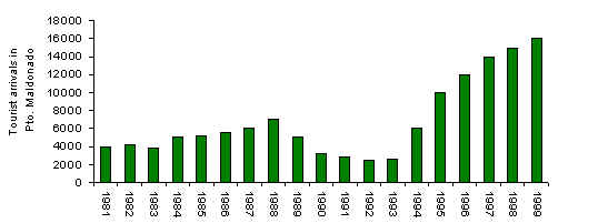
Figure 2.2. Foreign tourist arrivals in Puerto Maldonado from 1981-1999 (MITINCI).
The Lodges
Explorers’ Inn (EI)
This lodge is located on the southern bank of the Tambopata river (12�50�15��S, 69�17�30��W), at the confluence with the La Torre river, and 30 km SSW from Puerto Maldonado (Figure 2.1). The company Peruvian Safaris built the lodge in 1975 and it began to receive tourists in 1976. It was the first tourism venture to operate along the Tambopata river and it may be said that it was one of the first to introduce the concept of tourism and conservation to the area (Gunther pers. com.). Soon after the lodge was built (1977) the Peruvian government granted Protected Area status to 5.5 km2 of forest around the lodge which became known as the Tambopata Reserve Zone (Stewart 1988). Through its Resident Naturalist Program, which offered free room and board to graduate biologists in exchange for informing and guiding guests, the EI was successful in combining tourism with research. Investigations undertaken in the late 1970s and early 1980s found that this area is relatively unique and harbours the highest known levels of biodiversity on Earth. The 5.5 km2 of lowland rainforest around the lodge holds numerous world records for species density: Birds 596 (Parker et al. 1994); Butterflies 1,234 (Lamas 1985, 1994); Dragonflies and Damselflies 151 (Paulson 1985); Horseflies 73 (Wilkerson & Fairchild 1985) and Tiger beetles 29 (Pearson 1985). The creation of the TCRZ and BSNP would likely not have been possible without the original investigative studies undertaken around this lodge.
Currently the lodge receives general interest and specialist visitors (birdwatchers), who remain there on average for 3 days. The total length of the trail system habitually used by tourists from the lodge is 35 km and is the oldest and most extensive in the area. Erwin (1984) was the first to classify the forest types around the lodge, basing his system largely on hydrological and soil characteristics. Later, Nicholson & Phillips (unpublished) and Phillips (1993) further developed the classification by presenting full forest type descriptions with new information on floristic characters. Further floristic descriptions of the area were undertaken by Conservation International (1994). A total of nine distinct forest types can be recognised:
| Type A: Permanently Waterlogged Swamp Forest, dominated by the palm Mauritia flexuosa and more rarely by Lueheopsis hoehnei. This forest type is frequently associated with the poorly drained areas around oxbow lakes and is considered one of the successional phases in the slow process of forest recolonisation of these lakes. |
| Type B: Seasonally Flooded Swamp Forest, is characterised by an abundance of tall palms such as Scheelea butyracea, Euterpe precatoria, Oenocarpus bataua and Socratea exorrhiza. The canopy is normally low (<20 m) and broken, with a dense understorey of shrubs and small palms, especially Geonoma sp. and Bactris sp. Vines and scandent herbs are moderately abundant but large lianas are rare. Ground vegetation is restricted to areas of drier ground atop low hummocks, where the fern Adiantum latifolium is usually common. |
| Type C: Lower Floodplain Forest, an open early successional forest, situated on the banks of rivers, dominated by the cane Gynerium sagitatum and successional light demanding trees such as Tessaria integrifolia, Salix humboldtiana, Cecropia sp. and Ochroma sp. with frequent Ficus insipida, Croton sp. and Sapium ixamasense. This forest type is frequently disturbed by rising river waters after severe storms, particularly during the rainy season (Nov. – Apr.). Few trees reach more than 20-25 m in height. Small lianas, such as Paullinia alata, are common and can form locally dense tangles. Ground cover is sparse, mainly consisting of dense clonal patches of Calathea sp. and Heliconia sp. |
| Type D: Middle Floodplain Forest, a tall closed canopy of frequent Iriartea deltoidea, Astrocaryum gratum, Socratea exhorriza, Calycophyllum sp. and Spondias mombim. |
| Type E: Upper Floodplain Forest, palms such as Iriartea, Astrocaryum, Socratea remain frequent, although also present are large broad-leaved trees such as Chorisia sp., Ceiba pentandra and Pseudolmedia laevis. |
| Type F : Old Floodplain Forest, this forest type is a mature version of Type E except with a greater predominance of palms (30%), particularly Iriartea, and large broad-leaved emergents, including: Dipteryx alata, Spondias, strangling Ficus, Ceiba and in some cases Caryocar magdiliformis. The forest canopy is tall (>30 m) and is more continuous than other types. The dense shade caused by this closed canopy inhibits dense understorey growth, with the result that the understorey is relatively open. The fern Adiantum latifolium however remains dominant at ground level. |
| Type G: Terra Firme Clay Forest; Type H: Terra Firme Sandy Clay Forest and Type I: Terra Firme Ultrasand Forest, characteristic broad-leaved trees in these types are Bertholletia excelsa, Dipteryx, Cedrelinga cateniformis, Capirona sp., Parkia sp., Hevea brasiliensis and Coussapoa sp. These forest types are located on freely draining soils and are not subject to flooding. |
| Bamboo. Within the more poorly drained and/or disturbed areas of some of the aforementioned forest types can be found stands of bamboo (Guadua weberbaueri and G. angustifolia) which further adds to the habitat diversity of the area. |
The lodge was originally built on a small area of agricultural land belonging to the mestizo community of La Torre. As a consequence a small area of forest near the lodge is regenerated secondary forest. La Torre, is a small permanent settlement with a population of approximately 70 people located on the opposite banks of the Tambopata and La Torre rivers. The rivers afford the lodge relative isolation. East of the lodge is the native Ese�eja community of Infierno, established in 1976 and currently with 400 inhabitants. The forest surrounding an oxbow lake (Laguna Cocococha) that is used by the lodge is claimed by Infierno. Members of the community also collect brazil-nuts for 3 months of the year in areas to the south and east of the lodge�s trail system.
Cusco Amaz�nico Pueblo Hotel (CAPH)
This lodge is located on the northern bank of the Madre de Dios river (12�32�30��S, 69�03�20��W), 15 km ENE from Puerto Maldonado (Figure 2.1). The company Palma Real built and began operating the lodge in 1976. It was the first tourist installation to be implemented along the Madre de Dios river. From its initial stages it has developed its own form of tourism based on the biological, cultural and historical attractions of the area. In 1977 the government approved the formation of a private ecological reserve around the lodge totalling 10 km2. The status of the reserve prohibited the extraction or conversion of natural resources by the local inhabitants, although there is evidence that some resources, for instance the palm Euterpe precatoria, have been extracted over a large area. There is also evidence that the lodge itself is responsible for the majority of this.
In 1987 the government failed to renew the "ecological reserve" status of the majority of the land and subsequently previously forested lands close to the lodge were colonised and are now farmed. Furthermore, hunting pressure has grown significantly in the area as a consequence. Scientific collecting of mammals, birds, herpetofauna and vegetation was also undertaken periodically (Duellman 1987, Davis et al. 1991, Duellman & Salas 1991, Woodman et. al. 1991). Such research, complementary to that undertaken at the EI, further affirmed the importance of the Tambopata area in terms of biodiversity.
The lodge receives general interest tourists who remain on average for 3 days. The trail system that is habitually used by tourists staying at the lodge is one of the oldest, although at 5 km it is the least extensive in the area. The forest types found along the length of the trail network, following the above classification, include: Types A, B, E, and F. No bamboo is present. South of the lodge is a 45 ha island dominated by type C forest and currently used as a make-shift zoo. On both sides of the lodge, at a minimum distance of 0.5 km, are situated two farms belonging to families of the Lorin and Gamitana communities. These families have been known to use the trails for communication purposes as well as for hunting.
EcoAmazon�a Lodge (ECO)
This lodge is located on the northern bank of the Madre de Dios river (12�31�45��S, 68�56�10��W), 28 km ENE from Puerto Maldonado (Figure 2.1). It was constructed in 1993 by the Toledo family (Cusco). No research has previously been undertaken at the lodge. The lodge receives general interest tourists who remain on average for 3 days. The trail system habitually used by tourists is 15 km long. The forest types associated with the trail system and the immediate area around the lodge include types A, B, D, E, and F. No bamboo is present. To the north of the trail system are numerous palm swamps (Type A) where aquatic plants such as Apalanthe granatensis and Lemna aequinoctialis are sometimes present in the standing water. At a distance of 6.1 km from the lodge are two canopy platforms. These are juxtapositioned between three distinct habitat types: A, B and an unknown type of riverine scrub. Located opposite the lodge is a 30 ha island, "Isla de Mono", which is used as a make-shift zoo. The island is dominated by type C forest. The lodge is built in an area not associated with any established community, the nearest being approximately 5 km distant, although it is known that fishermen from the native Ese’eja community of Palma Real use the eastern-most trails to access other areas.
Sachavacayoc Centre and Sachavaca Inn (SACHA)
These two neighbouring lodges, separated by only 200 m, are located on the southern bank of the Tambopata river (12�51�15��S, 69�22�00��W), 35 km SSW from Puerto Maldonado (Figure 2.1). The Sachavacayoc Centre was constructed in 1994 by Newton College, an independent international school in Lima, as a centre for conservation and education. The Centre caters mainly for student groups, who stay for 7 days. The Sachavaca Inn is a relatively recent construction, finished in 1997, and caters for tourists, who stay 3 days on average. A small amount of research has been carried out in the forest shared by both lodges although to date no comprehensive inventories have been completed. The lodges have a common trail system consisting of a total of 18 km. The trail system is also used relatively often by tour groups from the Tambopata Jungle Lodge, situated 5 km upstream. The forest types which the trail system crosses include types A, B, E, F and small patches of G, although the majority of the forest under study was type F. All, except type A, have significant stands of bamboo associated with them.
The land on which these two lodges are built use to be small agricultural plots belonging to members of the Sachavacayoc community. Consequently a small portion of the forest surrounding each lodge is regenerating secondary forest. Some families of the Sachavacayoc community continue to live alongside both lodges. Small-scale selective logging has occurred within the area studied, with species such as Cedrela odorata and Cedrelinga cateniformis consequently being relatively rare. The local inhabitants also use the forest for the collection of Geonoma palm leaves (Palmiche), which they use for thatching. Local hunters also access the area along the trail system, and two families are known to hunt relatively frequently in the area.
Tambopata Research Center (TRC)
This lodge is located on the western bank of the Tambopata river (13�08�10��S, 69�36�40��W), 75 km SSW from Puerto Maldonado (Figure 2.1) in an isolated area of the TCRZ adjacent to the BSNP, and within 200 m of a macaw claylick, or ccollpa. It was constructed in stages, beginning in 1989 when it was purely a research centre dedicated primarily to the study of macaws (Nycander et al. 1995), and was modified and completed in 1994 as the principle activity switched to tourism. A significant amount of research has been undertaken at this site over the last 10 years and comprehensive inventories of some taxa are available (Emmons & Romo 1994, Rodriguez & Emmons 1994, Ascorra 1995, Salas 1995). The TRC caters for both its own tourists, who stay for approximately 4 days, and also those from the Tambopata Jungle Lodge who stay for an average of 2 days. The trail system used by all visitors extends for a total of 12 km. The forest types associated with the trail system and the immediate area around the lodge include types: A, B, C, D, E, F and G. Most have significant stands of bamboo. There is also a large number of pure stands of bamboo where natural disturbance has been severe, thus defining a unique forest type. The habitats at the TRC have been described in more depth by numerous authors (Foster et al. 1994; Kratter, 1995a, b, 1997). No permanent settlements exist within 40 km of this lodge and hunting is negligible.