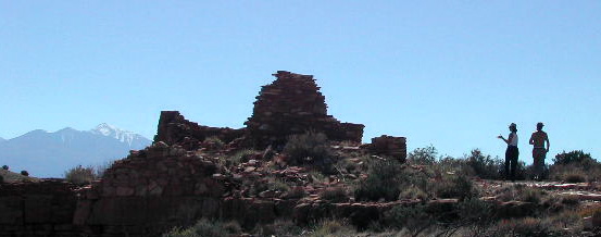
Saddle Butte
|
|
Saddle Butte
Sleeping good under the saddle, in the warm desert air. We woke and packed. Pancakes and eggs, first meal cooked and served in camp. Instant oatmeal. Choice of Preston's instant coffee, or David's French Roast Expresso. Maury brought Tang. Discussed the itinerary. David's plan for taking the Apache Trail was postponed. It was decided that Monument Valley would be a better place to camp tonight, and that would take a while to reach, being pretty far north. About half the length of the state away. Sunday morning quite and peace. We said farewell to the Butte for a week, and the looming Superstitions and headed back on US 64 to I-17 north to Flagstaff. The going was quite dramatic. We did stop for gas and supplies, such as they might be, and not everything was open Sunday morn. I read from Halka Chronic's "Roadside Geology of Arizona": Up the interstate through rocks of all ages: past "small faulted blocks of Precambrian metamorphic rocks....like miniature mountain ranges....exposed near the road: both gneiss and schist." You do get the idea.Mid morning found us at "basalt covered tablelands... narrow gorges cut by mountain fed streams through dark Precambrian metamorphic rocks." The road swung over a pass and there stretched out a view that made you gasp. The huge valley of the Verde River and up to the Mogollon Rim on the Northern Horizon. We stopped at Camp Verde gas station for cokes. No one wanted to go to the Casino above. Or stop at Montezuma Castle. Next time, perhaps. There is so much of quality to see in this wonderful state. About noon, we were heading toward the San Francisco Peaks, with Humphres Peak, highest in Arizona, showing early snows on top, rising above Flagstaff. We found another shopping center, and picked up supplies. More supplies. Groceries. Things like that. Soon we were sailing to the Painted Desert, past cinder-cone mountain-ettes, just below the Peaks, heading into Navajo country. Quartinary lava flows. That is what Halka calls them. Sunset Crater with its dusky rose color. We started looking for a place to picnic, and conveniently, the Wupatki National Monument came in sight. Perfect. Indian Pueblo ruins and picnic tables.
The Sinagua people lived here and built these dwellings. The origin of Sunset crater and most of these cinder-cones, was a burst of volcanic activity, probably beginning in the middle of somebody's cornfield like Paricutin in Mexico in 1943, and built these hills and mountains out of black cinders in the form of cone-shaped piles. Funny black mountains! This was in 1064, if tree rings are to be believed. But as soon as everything cooled down, the people came back and found that crops grew so much better in this volcano enriched soil!!! Nature's fertilizer goes to work. Apartment houses were built along the edges of the cinder fields, and a big population exploded, growing plenty of food! There was an abundant supply of rock for the houses: Moenkopi sand stones and mud stones, deep red.
When the droughts came, and dust-bowl conditions prevailed season after season, the farmers and their families left, and we know not where they went. Unless they are really the ancestors of the Hopi, who claim them. Fine things to look at and think about during our simple lunch. Peanut butter and jelly always works no matter where. The perfect comfort food. We wandered the ruins, wondering about the Sinagua peoples that built these small roomed structures and farmed this arid land. Makes you wonder what our cities and towns will look like in a thousand years. What will we be like then? What will be the official opinion? Will we even exist in our present state? Or will Homo Sapiens Sapiens be the little-understood cro-magnum species of the hominoids by then?
All we are is dust in the wind...
Climates have changed relatively fast out here in this country. Easterners tend not to like it, at first, at least. Not for a place to live, certainly. It is wildly different from the red clay and loamy wet forest lands that grow so naturally from the Atlantic coast to the Mississippi. The mountains out here are so stark and dramatic, compared to our tree-covered little Appalachians. The first to come were the disaffected, the exiles and rejects sought to make a life in this part of the world. Oh, Pioneers. The Mormons and the fortune hunters. The alianated and the opportunists. Gamblers and Nomads. The geographically curious, the historians and scientists. This was some of the last unexplored territories of the world late into the 19th Century. There were big gaps in the maps of the US territories beyond the Rockies. When John Westley Powell and his crew of "scientists" started paddling the Green River to the Colorado, very little was known for sure. The Grand Canyon was "terra incognito". And of the several hundred miles of the river above, only certain fords and trading posts, Indian settlements, and not all of them were marked in the right place on the Government maps..... Powell believed that the West was not suited to Eastern style development. Taking the clues that nature offers, flora does not occur in Eastern abundance. Water has to be rationed and conserved. Large populated cities put a huge strains on natural resources: it is like trying to populate the Moon. And if man uses these resources faster than nature can replenish them......
But Homo Sapiens Sapiens do change things. When we came out here, we had to get rid of all those pesky buffalo herds. Which got rid of the Native's of the plains way of life. And we had to kill off the big cats that were eating our lambs and calves so beloved by those back east. We put up fences and roads and rails, and fought the Natives who used this land and these resourses wisely and instinctively, and we conquered them and forced them to be content with the barest, hardest to use land, land we did not have the patience to till.... But those natives were immigrants too, long before us, coming from Asia across the Bearing Straights at a fabled time when a land bridge actually connected the continents. And either the climate change or their hunting practices got so good that the mastodons and woolly mammoths and saber-toothed cats they found here became extinct. Is it that men are carnivores as long as four legged food is available, and only become vegetarian when meat on the hoof is on longer available?
But back to the future, we packed up and heading north up US 89. As wonderful as any highway I have ever traveled. Soon we were down to Cameron, where the road to the rim, Arizona 64, heads west up to the east rim of the Grand Canyon. But that would be on tomorrow's itinerary. We cross the Little Colorado, flowing lazily in its 50 foot deep trench at this point. The next time we would see it, you would be looking down about 800 feet. And then from the Canyon rim, down about 4000 feet!!! We are talking in big scales now. On up the road, we might as well be driving through Oz. The erosion of this land is unimaginably strange, with bad lands, and funny shaped hills of many colors, pinks and lavenders, chocolates, rose and grays. Lindley and David were convinced that they were mine tailings! (Some actually may be.) We leave the road to the North Rim of the canyon and Page, and head north-east past Tuba City to Kayenta on US 160. The Dinosaur Tracks. A scenic diversion, but we put that off for the next day, too. The afternoon is advancing. "Burning daylight", friend Ronnie would say.
Up past Black Mesa, the coal mining operation. This frightful mis-use of resources, has been a huge irritation to the conservationists and greens of all stripes since the Navajo's started selling their coal at one dollar a ton to the power industry. So all the lights of Las Vegas, and that pollution haze that hangs over the deserts and canyons of northern Arizona, southern Utah and Nevada, originally come out of this coal rich Mesa, and the strip-mining that has gone on for such a long time. 180 feet or so of overburden are stripped away, the coal is shoveled out and sent to power plants as far away as 274 miles, by slurry, wasting precious water, and rail cars. The only up side, if that is what it is, is like all our fossil fuels. At the rate we are using them, the ones we have now will be gone in a few generations; all used up. Then mankind will have to wait several million years for nature to make more from our swamps and marshes we so readily drain for dry land to build our life on. The only good thing about the Black Mesa project, is that all the overburden that was taken away to get to the black stuff, has to be replaced, and planted with native grasses and clover.
Heading into Kayenta, I note with horror that the El Capitan Diner is gone! Replaced by what looks like a Hampton Court motel tower. I had been looking forward to one of their huge Navajo Tacos for several years now. But the shinny little diner was nowhere to be seen, and the shopping strip where I bought some presents the last time I was here, had expanded. Things were looking theatrically quaint and even chique. New Post Office and everything. This town is thriving! Tourists have found it. Helas!!
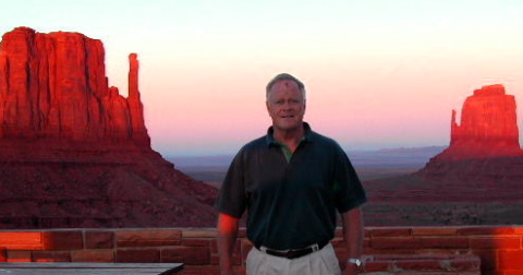
Highway US 163 takes you up to Monument Valley Tribal Park and such great little places as Mexican Hat and the Goosenecks of the San Juan. We would get as far as the Park. at least. Through missing teeth in the Comb ridge, and into that high windy valley, with the startling monuments, sandstone from ancient times of the Permian Sea. The rest of these vertically jointed blocks have reverted back into valley sands, leaving the Mittens and other striking buttes standing tall
for the backdrop for many great John Ford movies, usually starring John Wayne. We arrived about an hour before sunset, a great time to be at Mitten View Campground. Many things had changed since I was there last, with a commercial strip in place as you turn off US 163 into the park. We arrived after five, the witching hour, as the attendants all went home to supper with their wives and husbands, so we did not get to pay that night for our camping space. That has happened before. The one concession open, the book store/souvenir shop, did have one local native longhair in attendance. He explained that we could just pay in the morning, but offered to sell me some tokens that could be used in the showers! At a buck each, I bought enough for our group. By the time we finished exploring the area, and enjoying that spectacle that occurs every cloudless sunset, the last rays rising up those amazing structures, it was dark, and David and I set to prepare supper by flash light, since all my Coleman lanterns have bitten the dust. I am not good with those gassy wonders, anyway. I have problems keeping the wicks in shape. Plus I hate the glare and intensity of the light they produce. We heated and ate the tomalleys David had bought the night before at a Taco wagon in Apache Junction. Really good out here. I made some ramen pasta of some description and a can of smoked oysters. Many find that being in Desert conditions, you are not very hungry. I can feel my metabolism at work out here, using the food I ingest for what it is intended. Desert rats are lean and mean. But I carry candy and nuts for energy. On hikes I always pay attention to the gorp mixtures. Trail life needs this boast of energy as much as the body needs the water you have to carry, and moleskin and alcohol for blisters. (My callouses have developed to the point that I do not use as much of that stuff as when I was a real tenderfoot.)
Another night of great sky. I took my shower sometime in the middle of the night. The rest room was heated, but the water had no hot/cold control, and was luke-warm. But good to clean up. (I remember this rest room from a very cold windy night up her many years back. Three German boys over here on a cycle tour, had chosen this bit of warm space to cook there supper!!! I had actually exchanged addresses and corresponded with one of the fellows for a few years.) Back at camp I got familiar once more with the starry dynamo as seen from our point of view here in Arizona/Utah. Morning broke, time for coffee and oatmeal. We had eggs left for those who wanted them and made more pancakes..... As some showered for the day, Dave, Maury and I went on a little ramble in the flats below, noting the birds and did see a silver tailed fox in the rocky cliff side. We paid up, realizing that we did not have to. Those people seem to enjoy whatever money they take in during the day, and at night, the campers have charge, and if you come in after hours that is your business not theirs. Paying for those times is by honor system. There were some dogs hanging out there, looking hungry and pathetic. They had caused a disturbance with one of our neighbors the night before. An older codger in a camper, with a dog of his own tied up as required, was positively irate, and went around seeking the owner of the strays. He had thrown rocks at them. I suggested they were feral, which he doubted, when he asked if they were ours. But we did not feed them, something that must have bothered dog-loving Stacey.....
Load up and head on back down to the Canyon where our reserved camp ground awaited. On the way we stopped at the Dinosaur Track. Got a lecture from a very knowledgeable Navajo woman, quite young, who was from a family in the area, but had studied Geology in college. The prints are from the bipedal, tyrannosaur type, "chicken" beasts, carnivore terrors who waded Jurassic shores 200 million years back, leaving foot-prints in these muds, now called Kayenta Formation mud stones and shale.
About 15 years back, when Maury and I were out there with couple I knew from what I thought was AA, my young friend made a deal with the young Indian attendant, and arrange to score some pot, without us knowing about it, but when he was driving back to the fellow's house to score, we smelled a rat and diverted his plans. He was indeed pissed, but that spared us some pain later. I am so much wiser now choosing my friends. The crew I am traveling with this trip is just fine. Mature, intelligent and appreciative.
The little Hopi community of Tonalea across these flats is nestled under small cliffs and rugged hills in an area of springs. The green around their hogums is plainly visible from the road here. The map show a complex of roads, unpaved mostly it seems, that lead back and there is a "Preston Mesa", which I would like to visit someday..... That young fellow was probably part of the family that is on hand at the Dinosaur tracks, may own the land the tracks are on. He was on duty there with his grandmother, I am sure the same woman in the pick-up, only looking a good bit older. That fellow was probably one of the men who drove up to see how things were going, and also to eat some Navajo fry bread or lamb stew served with coffee, another feature at this site. The grandmother makes jewelry for sale to the public here as well. She was
on hand that day, quite old, but still the object of great respect from her family. She sat in a son's pickup, beaming at the tourists. She still speaks no english. Has never needed to, I guess, and I am sure she is the same matron that dominated the family back when we stopped here back in the 80's, and made all the business deals that were outlined by our present host. (But probably not the dope deal!) We contributed about 25 bucks to the girl for her time and explanations. She said there was no fee as such, but would accept contributions. She was very informative and we inquired about family history and Indian customs and procedures as well. She seemed willing to go into as much detail as we asked for. A very smart and attractive person....