| warangal district profile |
| location and area |
| This district derives its name from Warangal its headquarters, earlier known as Orugallu (Ekasilanagara) meaning single stone. It was founded in the twelfth century by Prola Raja of the Kakatiya dynasty. Warangal was one of the largest districts in the erstwhile Hyderabad State. Its bifurcation in 1953 led to the formation of Khammam district. It is bounded on the north by Karimnagar district, on the west by Medak, on the south by Nalgonda and on the west and south east by Khammam. |
| culture and lifestyle |
| A majority of the population directly or indirectly depends on agriculture for their livelihood. |
| leisure |
| Entertainment (folk, theatre, cinema, etc): As in the other parts of country cinema is the popular form of entertainment. Sankranthi, the harvest season, Ugadi (Telugu New Year), and other major festivals like Dasara, Deepavali are celebrated with religious fervor. Most of the families go out for "Vanabhojanalu" (group going to a garden on the outskirts for picnic) during the Karthika month. |
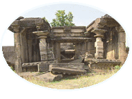
| Language � Telugu is the main language spoken in the region. Food � Rice is the staple food but people also prefer wheat & jowar. Family, marriage & kinship- The traditional joint family is now paving way to nuclear families. Marriages are conducted mostly within the community. Dressing- It is influenced by profession. Farmers prefer dhoti. Art forms- During the Kakatiya reign arts and crafts received patronage and flourished. The Kakatiyas built the thousand pillar temple, Warangal fort, Ramappa temple,Kota Gullu Temple at Dhanpur and Padmakshi temple and excavated many tanks like Pakhal. Literacy: According to 1991 census, Male Literacy 51%, Female literacy 32% |
| social |
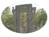 |
| gateway of warangal fort |
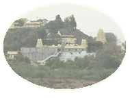 |
| bhadrachalam temple |
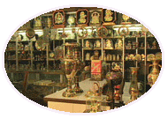 |
| lepaakshi handicrafts |
| Srikanth's site |
| | home | about ME | photo gallery | my friends | paintings | cool links | contact ME | UR page | |
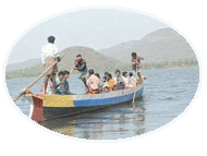
| rivers,canals and waterways |
| The Pakhal lake is situated in the revenue village of Pakhal in Gudur mandal and is 12 km. to the east of Narasampet and 45 km. East of Warangal. It is an artificial lake formed by a 2000 yards dam across the Pakhal river. The Laknavaram lake lies in the limits of Laknavaram village in Mulug mandal at a distance of 69.23 km. from Warangal. The Ramappa lake is situated to the northeast of Warangal in Palampet in Mulug mandal. The Ghanpur lake, which lies in Mulug mandal is situated in Ghanapuram village. The lake serves an area of nearly 1620 hectares. In addition to the above lakes, there are some important tanks at Nagaram, Wardhannapet, Arjunpatla, Katakshapuram etc. |
| Warangal is predominantly an agricultural district with a large number of artificial lakes. The predominant crop grown here is paddy, which accounts for 34 % of the total cultivated area, white pulses account for 23.57 %. |
| socialagriculture and irrigation |
| wyra |
 |
 |
| ghanpur temple |