WETLAND DELINEATION OF LODI MARSH STATE WILDLIFE AREA, DANE, COUNTY, WISCONSIN
Plb 445-Wetland Ecology
Honu, Y. A. K., and Walker, C. H.
Presented
October 19, 2001
Southern Illinois University
Carbondale, IL
ABSTRACT
Vegetation, soils, and hydrology were examined in a marsh restoration site in Dane County, Wisconsin, in order to delineate the upper limit of the wetland. A transect line was set in a southeast to northwest orientation with 3 sampling points randomly located along its axis. Plot 1 was located at the lowest elevation, with plots 2 and 3 progresively higher in elevation. Relative percent cover of hydrophytic vegetation decreases in going from the floodplain to the top of a 1,180 feet hill. The relative % cover ranges from 81.4 % at plot 1 to 60.5 % at plot 2 to 3.5 % at plot 3. Hydric soil and surface inundation was observed in the floodplain with no indications in the upland area. It was concluded that the lower two plots were classified as wetland and the edge of the wetland must be located between plots 2 and 3.
INTRODUCTION
Wetlands are fragile ecosystems and for a management plan to be drawn for these systems it is important to know the boundaries of the wetland. Three main criteria are used in delineating wetlands, namely, 1) hydrophytic vegetation, 2) hydric soils, and 3) wetland hydrology (USACOE 1989). These three criteria must be met before an area can be classified as a wetland (Mendelssohn 1995).
Hydrophytic vegetation has been defined as "macrophytic plant life growing in water, soil, or on a substrate that is at least periodically deficient in oxygen as a result of excessive water content" (USACOE 1989). Hydric soils have been defined as "soils that are saturated, flooded, or ponded long enough during the growing season to develop anaerobic conditions in the upper part" (Soil Conservation Service 1994). An area is said to have wetland hydrology when it is "…saturated to the surface or inundated at some point in time during an average rainfall year" (USACOE 1989).
The objectives of our study were to 1) to delineate the upper boundary of the wetland and 2) to provide information on the species present in the Lodi Marsh State Wildlife Area.
STUDY SITE
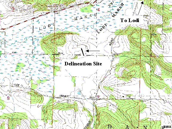
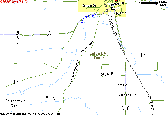
The study site is located about 3.0 miles southwest of the town of Lodi in Dane County, Wisconsin (Figure 1). The area that was delineated in this study is located on the west side of the Springfield Road, 0.5 miles north of Lee Road, in the Lodi Marsh State Wildlife Area. The study area was formerly used for the growing of agronomic crops, and has been undergoing remediation in order to restore it to being a wetland. The transect line was located in the southwest corner of section 4 and the northwest corner of section 9 in township 9N, range 8E (Figure 2).
The area delineated is on a southeast-facing slope that drains into Spring Creek. The Creek flows into Lake Wisconsin about 5.0 miles north-northwest of the study site. The range in elevation of the site was 860-900 feet above sea level in traversing from plot 1 to plot 3 along the transect line (Figure 2).
Glaciers that inched southward from Canada 12,000 to 15,000 years ago sculpted the 1000-acre Lodi Marsh State Wildlife Area. The ice age glaciers widened and partially filled valleys with terminal moraine, made up of porous sand and gravel layers, and rounded the dolomite hills. The bogs, fens, and marshes in the area receive groundwater that is stored in the glacial sediments.
METHODS
We laid out a 1 m2 quadrat and identified all plant species in the quadrat according to Reed (1988, Table 1). The Daubenmire scale was used to estimate the % cover of all identified species (Daubenmire 1959, Table 2).
We used a shovel to dig down in the soil about 20 cm and took soil samples. We compared the soil color with the Munsell soil Color Chart (Munsell Corporation 2000) and looked for oxidized rhizospheres (root channels). The presence of iron (Fe) was tested by using alpha,alpha-dipyridyl .
RESULTS
VEGETATION
The total relative percent cover of the wetland species was 81.4% at plot 1, and wetland species of plants ranged from 0.9 to 34.9 % (Table 3). The dominant species was Scirpus cyperinus L.Beauv. and it accounted for 34.9 % the total relative % cover (Table 3). Twenty percent of the species were upland species. (Table 3). No tree species were observed in the vicinity of the plot.
The total relative percent cover of the wetland species at plot 2 was 60.5 % and ranged from 2.1 to 20.8 % (Table 4). The dominant species were Aster novae-angliae L. and Conyza canadensis (L.) Cronq., each accounting for 20.8 % of the relative per cent cover (Table 4). Seventy percent of the species were wetland species (Table 4). Two species of genus Juncus (3 % cover) and Malva (3 % cover) could not be identified (Table 4). No tree species was observed in the vicinity of the plot.
The total relative percent cover of the upland species at plot 3 was 96.6 % and ranged from 3.4 to 24.1 % (Table 5). Pennisetum glaucum (L.) R. Br. was the only wetland species observed (Table 5). Daucus carota L. (3.5 %) and Vicia sativa ssp. nigra (L.) Ehrh (0.5 %) were both present, but their vegetation status was not listed (Table 5, USACOE 1989). Two genera were not identified to species, Juncus (3 % cover) and Malva (3 % cover) and so were not included in Figure 5. No tree species was observed in the vicinity of the plot.
SOILS
Soils ranged from dark brown (10YR 2/1) at Plot 1, black (gley 1 2.5/N) at Plot 2 to reddish-brown (5YR 3/3) at Plot 3 (Table 7). Since soils must have chroma values of 2 or less in order to be considered hydric, plots 1 and 2 were classified as hydric soils and plot 3 was classified as an upland soil. None of the plots tested positive when treated with alpha,alpha-dipyridyl. This solution is used to confirm the presence of ferrous (Fe++) in the soil. If Fe++ is present, the soil material will turn a bright pink or red color within a few seconds (NTCHS 2001).
HYDROLOGY
Neither drift lines, surface scouring, nor watermarks were observed at any of the 3 plots. However inundations were observed at plots 1 and 2.
DISCUSSION
HYDROPHYTIC VEGETATION
Hydrophytic vegetation is one of the important characteristics used in determining the wetland status of an area (USACOE 1989). Every plant has a probability of either occurring in a wetland or upland or both. Hydrophytic species (OBL, FACW & FAC) have a probability of 34 % or greater of occurring in a wetland, whereas upland species (FACU & UPL) have a probability of 67 % or greater of occurring in an upland (USACOE 1989; Table 1). The relative % cover is a good measure of the probability of plant species occurring in a wetland.
Relative percent cover of herbaceous species decreases from the floodplain (Plot 1) to the upper portion of the transect line (Plot 3). The relative % cover at plot 1, 2 and 3 were 81.4%, 60.5% and 3.5 %, respectively. This is in support of what have been defined in the findings of USACOE (1989). Plot 1 was located in the floodplain and may account for the high number of hydrophytic species observed. Plot 2 was located close to the floodplain, but its higher elevation may account for the decrease in the number of hydrophytic species. The low per centage of hydrophytic vegetation observed at plot 3 may be due to its location on higher ground. This plot was intended to locate the upper upper part of the wetland. According to USACOE (1989) if more than 50 % of the dominant species are wetland indicator species (OBL, FACW & FAC, Table 2) then hydrophytic vegetation is present in the area. Therefore, plot 1 and 2 met the hydrophytic vegetation criteria.
Obligate hydrophytic herbaceous species were observed in the quadrats at plots 1 and 2 (Tables 3-5). The species Leesia oryzoides (L) Swartz. formed 18.6 % of the relative cover at plot 1 while Carex vulpiinoidea Michx and Epilobium perfoliatum L formed 8.3 % of the relative cover at plot 2. These plots were laid in or close to the floodplain area and may account for the presence of obligate hydrophytic species.
No tree species were observed in the close vicinity of any of the plots. According to Drs. Middleton and Rossa (Personal Communication), the study area was formerly farmed and has been somewhat restored. The tributary to Spring Creek is at a lower elevation now than it was prior to when the land was being farmed.
HYDRIC SOIL & WETLAND HYDROLOGY
Soil color is the most diagnostic indicator of hydric soils in wetlands (USACOE 1989). Chroma 2 or less is an indicator for hydric soils (USACOE 1989). Black, various shades of gray, and the darker shades of brown and red are low chroma colors (USACOE 1989). Plot 1 and 2 had hydric soil, but plot 3 did not. This may be due to the elevational difference between plot 3 and the other two plots.
Orange or reddish-brown color along living root channels are the result of soil saturation for a long period during the growing season (USACOE 1989) and is a good indicator of wetland hydrologic conditions (Mendelssohn 1995). This was not personally observed at any of the 3 plots.
Surface inundation was observed around plots 1 and 2 and none at plot 3. Bacause plots 1 and 2 were located in the marsh while plot 3 was located on the upland.
In conclusion plots 1 and 2 were determined to be wetland, but the outer boundary was not determined. Further studies at the marsh should try to determine the outer boundary of this wetland. A transect line should be set up between plots 2 and 3 to try to delineate the outer boundary of this wetland site.
BIBLIOGRAPHY
Daubenmire, R. F. 1959. A canopy-coverage method of vegetation analysis. Northwest Science 33:43-47.
Mendelssohn, A., Kleiss, B. A., and Wakeley, J. S. 1995. Factors controlling the formation of oxidized root channels: a review. Wetlands 15: 37-46.
Middleton, B. A. 199. Wetland restoration, flood pulsing and disturbance dynamics. John Wiley and Sones, New York.
Munsell Corporation. 2000. Munsell soil color charts. Munsell color, GretagMacbeth, New Windsor, New York.
National Technical Committee for Hydric Soils. 2001. Hydric Soil Tech. Note 8: Use of alpha-alpha-dipyridyl. http://www.statlab.iastate.edu/soils/hydric/hstn.html
MapQuest.com, Inc. 2001. 1730 Blake Street, Suite 310, Denver, CO. http://maps.yahoo.com/
Reed, P. B. 1988. National list of plant species that occur in wetlands: national summary. Biological Report, 88 (24), Washington, DC.
Soil Conservation Service. 1994. National Food Security Act Manual, 3rd edition.
U.S.A.C.O.E. 1989. Federal Manual for Identifying and Delineating Jurisdictional Wetlands. Cooperative Technical Publication. U.S. Army Corps of Engineers, U.S. Environmental Protection Agency, U.S. Fish and Wildlife Service, and U.S.D.A. Soil Conservation Service, Washington, D.C.
USDA, NRCS. 2001. The PLANTS Database, Version 3.1 (http://plants.usda.gov). National Plant Data Center, Baton Rouge, LA.
Table 1. Wetland Vegetation Classification (USACOE 1989).
|
Vegetative Classification |
|
Symbol |
|
Estimated probability of occurrence in wetlands (per cent) |
||
|
Obligate Wetland |
|
OBL |
|
|
> 99 |
|
|
Facultative Wetland |
|
FACW ± * |
|
|
67 - 99 |
|
|
Facultative |
|
FAC ± * |
|
|
34 - 66 |
|
|
Facultative Upland |
|
FACU ± * |
|
|
1 - 33 |
|
|
Obligate Upland |
UPL |
< 1 |
||||
*
A plus sign indicates that a species will fall towards the upper end of the range, a negative sign denotes that a species will fall towards the lower end of the range.
Table 2. Daubenmire Scale for estimating per cent cover (Daubenmire, 1959).
|
Index |
|
Per cent Cover |
||
|
Range |
|
Mid point |
||
|
1 |
|
0 – 1 |
|
0.5 |
|
2 |
|
2 - 5 |
|
3.5 |
|
3 |
|
6 - 25 |
|
15.5 |
|
4 |
|
26 - 50 |
|
38 |
|
5 |
|
51 - 75 |
|
63 |
|
6 |
|
76 - 100 |
|
88 |
Table 3. Relative per cent cover of herbaceous species, Plot 1, delineation of Lodi marsh, Dane County, Wisconsin, September 7, 2001.
|
Herbaceous Species |
|
Vegetation Type |
|
% Cover |
|
Relative % Cover |
|
Wetland Species |
|
Acalypha virginica L. |
|
FACU |
|
10.0 |
|
9.3 |
|
- |
|
Bidens frondosa L. |
|
FACW |
|
3.0 |
|
2.8 |
|
2.8 |
|
Conyza canadensis ( L.) Cronq. |
|
FAC- |
|
1.0 |
|
0.9 |
|
0.9 |
|
Scirpus cyperinus (L.) Kunth. |
|
FACW |
|
37.5 |
|
34.9 |
|
34.9 |
|
Echinochloa crus-galli (L.) Beauv. |
|
FACW |
|
20.0 |
|
18.6 |
|
18.6 |
|
Leersia oryzoides (L.) Swartz. |
|
OBL |
|
20.0 |
|
18.6 |
|
18.6 |
|
Pennisetum glaucum (L.) R. Br. |
|
FAC |
|
3.0 |
|
2.8 |
|
2.8 |
|
Rumex crispus L. |
|
FAC+ |
|
3.0 |
|
2.8 |
|
2.8 |
|
Trifolium repens L. |
|
FACU+ |
|
10.0 |
|
9.3 |
|
- |
|
Total % cover |
|
|
|
107.5 |
|
100.0 |
|
81.4 |
Table 4. Relative per cent cover of herbaceous species, Plot 2, delineation of Lodi marsh, Dane County, Wisconsin, September 7, 2001.
|
Herbaceous Species |
|
Vegetation Type |
|
% Cover |
|
Relative % Cover |
|
Wetland Species |
|
Acalypha virginica L. |
|
FACU |
|
3.0 |
|
6.3 |
|
- |
|
Aster novae-angliae L. |
|
FACW |
|
10.0 |
|
20.8 |
|
20.8 |
|
Bidens frondosa L. |
|
FACW |
|
1.0 |
|
2.1 |
|
2.1 |
|
Carex vulpinoidea Michx. |
|
OBL |
|
3.0 |
|
6.3 |
|
6.3 |
|
Conyza canadensis (L.) Cronq. |
|
FAC- |
|
10.0 |
|
20.8 |
|
20.8 |
|
Epilobium coloratum Biehler. |
|
OBL |
|
1.0 |
|
2.1 |
|
2.1 |
|
Eupatorium perfoliatum L. |
|
FACW+ |
|
1.0 |
|
2.1 |
|
2.1 |
|
Melilotus alba Medikus. |
|
FACU |
|
3.0 |
|
6.3 |
|
- |
|
Pennisetum glaucum (L.) R. Br. |
|
FAC |
|
3.0 |
|
6.3 |
|
6.3 |
|
Solidago canadensis L. |
|
FACU |
|
10.0 |
|
20.8 |
|
- |
|
Trifolium repens L. |
|
FACU+ |
|
3.0 |
|
6.3 |
|
- |
|
Total % cover |
|
|
|
48.0 |
|
100.0 |
|
60.5 |
Juncus
spp. (3.0% cover) and Malva (3.0% cover) could not be identified to species.
Table 5. Relative per cent cover of herbaceous species, Plot 3, delineation of Lodi marsh, Dane County, Wisconsin, September 7, 2001.
|
Herbaceous Species |
|
Vegetation Type |
|
% Cover |
|
Relative % Cover |
|
Wetland Species |
|
Ambrosia artemisiifolia L. |
|
FACU |
|
3.5 |
|
24.1 |
|
|
|
Melilotus officinalis (L.) Lam. |
|
FACU |
|
3.5 |
|
24.1 |
|
|
|
Setaria faberi Herrm. |
|
FACU+ |
|
3.5 |
|
24.1 |
|
|
|
Pennisetum glaucum (L.) R. Br. |
|
FAC |
|
0.5 |
|
3.4 |
|
3.4 |
|
Tridens flavus (L.) A. S. Hitchc. |
|
UPL |
|
3.5 |
|
24.1 |
|
|
|
Total % cover |
|
|
|
14.5 |
|
100.0 |
|
3.4 |
Daucus carota
L. (3.5 %) and Vicia sativa ssp. nigra (L.) Ehrh (0.5 %) were both present, but their vegetation status is not listed.
Table 9: Combined plant species list of delineation site in Lodi Marsh State Wildlife Area, Dane County, Wisconsin, September 7, 2001
|
|
Name of Species |
Indicator |
|
1 |
Acalypha virginica L. |
FACU |
|
2 |
Ambrosia artemisiifolia L. |
FACU |
|
3 |
Aster novae-angliae L. |
FACW |
|
4 |
Bidens frondosa L. |
FACW |
|
5 |
Carex vulpinoidea Michx. |
OBL |
|
6 |
Conyza canadensis ( L.) Cronq. |
FAC- |
|
7 |
Echinochloa crus-galli (L.) Beauv. |
FACW |
|
8 |
Epilobium coloratum Biehler. |
OBL |
|
9 |
Eupatorium perfoliatum L. |
FACW+ |
|
10 |
Leersia oryzoides (L.) Swartz. |
OBL |
|
11 |
Melilotus alba Medikus. |
FACU |
|
12 |
Melilotus officinalis (L.) Lam. |
FACU |
|
13 |
Pennisetum glaucum (L.) R. Br. |
FAC |
|
14 |
Rumex crispus L. |
FAC+ |
|
15 |
Scirpus cyperinus (L.) Kunth. |
FACW |
|
16 |
Setaria faberi Herrm. |
FACU+ |
|
17 |
Solidago canadensis L. |
FACU |
|
18 |
Tridens flavus (L.) A. S. Hitchc. |
UPL |
|
19 |
Trifolium repens L. |
FACU+ |
Table 10. Soil characteristics based on the Munsell Color Chart, delineation site in Lodi Marsh State Wildlife Area, Dane County, Wisconsin, September 7, 2001
|
Plot |
|
Hue |
|
Value |
|
Chroma |
|
Fe++ |
|
1 |
|
10YR |
|
2 |
|
1 |
|
negative |
|
2 |
|
Gley1 |
|
2.5 |
|
N |
|
negative |
|
3 |
|
5YR |
|
3 |
|
3 |
|
negative |
Figure 1. Highway map showing the location of the delineation site in Lodi Marsh State Wildlife Area, Dane County, Wisconsin, September 7, 2001 (MapQuest 2001).
Figure 2. Topographic map showing the location of the delineation site in Lodi Marsh State Wildlife Area, Dane County, Wisconsin, September 7, 2001 (USGS 2000).