A WETLAND DELINEATION OF A WILLOW-SEDGE RIPARIAN MARSH, ASHLAND COUNTY, WISCONSIN
PLB 445-Wetland Ecology
Walker, C. H., and Honu, Y. A. K.
October 5, 2001
Southern Illinois University
Carbondale, IL
ABSTRACT
Vegetation, soils, and hydrology were examined in a willow-sedge riparian marsh in Ashland County, Wisconsin, in order to delineate the upper limit of the wetland. A transect line was set in a north to south orientation with 3 sampling points along its axis. The lowest sampling point (plot 1) was north of the other 2 sampling points and was the only point that met all 3 criteria of the Federal Manual for Identifying and Delineating Jurisdictional Wetlands. It was concluded that the edge of the wetland must be located between plots 1 and 2.
INTRODUCTION
Wetlands are fragile ecosystems and for a management plan to be drawn for these systems it important to know the boundaries of the wetland. Three main criteria are used in delineating wetlands, namely, 1) hydrophytic vegetation, 2) hydric soils, and 3) wetland hydrology (USACOE 1989). These three criteria must be met before an area can be classified as a wetland (Mendelssohn 1995).
Hydrophytic vegetation has been defined as "macrophytic plant life growing in water, soil, or on a substrate that is at least periodically deficient in oxygen as a result of excessive water content" (USACOE 1989). Hydric soils have been defined as "soils that are saturated, flooded, or ponded long enough during the growing season to develop anaerobic conditions in the upper part" (Soil Conservation Service 1994). An area is said to have wetland hydrology when it is "…saturated to the surface or inundated at some point in time during an average rainfall year" (USACOE 1989).
The objectives of our study were to 1) to delineate the upper boundary of the wetland and 2) to provide information on the species present in the riparian –marshy area.
STUDY SITE
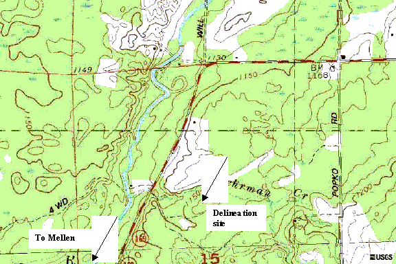
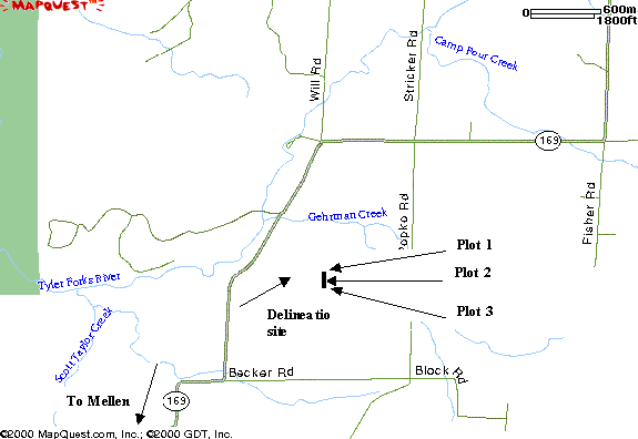
The study site is located 4.5 miles northeast of the town of Mellen in Ashland County, Wisconsin. The willow-sedge riparian marsh that was delineated in this study is located on the Glen Colver farm. The Colver farm is located on the east side of Highway 169, 1 mile north of Becker Rd (Figure 1) in the central part of township T45N R2W S15 (Figure 2).
The area that was delineated is on a north-facing slope that drains into Gehrman Creek. The creek flows into the Tyler Forks River 0.25 miles west of the study site in Copper Falls State Park. The range in elevation of the site was 1140-1160 feet above sea level.
METHODS
We laid out a 1 m2 quadrat and identified all plant species within the plot (Reed 1988; Table 1). The Daubenmire scale was used to estimate the % cover of all identified species (Daubenmire 1959, Table 2). The nearest large tree in the four cardinal directions from the quadrat were identified and classified (Reed 1988).
We used a shovel to dig down in the soil about 20 cm and took soil samples. We compared the soil color with the Munsell Soil Color Chart (Munsell Corporation 2000) and looked for oxidized rhizospheres (root channels). The presence of Iron (Fe) was tested by using alpha
,alpha-dipyridyl .RESULTS
VEGETATION
Carex lacustris was the dominant species at Plot 1, accounting for 80.7 per cent of the total relative % wetland cover. Ostrya virginiana was the only species observed that was not classified as a wetland species. A total of 99.5 per cent of the species at Plot 1 were wetland species (Table 3).
Salix discolor was observed on the north, east, and west sides of the quadrat.
Betula alleghaniensis was growing to the south of the quadrat where the land started to increase in elevation. Both of these species are classified as wetland species (Table 4).
Maianthemum canadense and Populus balsamifera were the 2 wetland species recorded at Plot 2 (Table 5) and accounted for 3.8 per cent of the relative per cent cover. An unknown species of sedge accounted for 39.7 per cent of the relative per cent cover. Consequently the vegetation classification type could not be assigned for this species and was omitted from the relative percent cover estimation.
Acer rubrum made up 50 per cent of the per cent cover at plot 2 and it is a wetland species (Table 6). Ostrya virginiana and Tilia americana are both upland species and they accounted for the remaining 50 per cent cover.
Abies balsamea was a codominant species at plot 3 (Table 7). It is classified as a wetland species and accounted for 23.1 per cent of the relative per cent cover (Table 7). Fraxinus americana was the other codominant species, but it is classified as an upland species. Four other species were classified as wetland species, bringing the total of wetland species cover up to 53.9 per cent. Betula alleghaniensis and Carpinus caroliniana are both classified as wetland species and together totaled 50 per cent of the wetland cover (Table 8).
The total number of trees and herbaceous species observed at the three plots were 23 and 65.2% of these were wetland species (Table 9).
SOILS
Soils ranged from black (10R 3/1) at Plot 1, dark brown (7.5YR 3/3) at Plots 2 to reddish-brown (5YR 3/4) at Plot 3 (Table 10). Since soils must have chroma values of 2 or less in order to be considered hydric, only the soil of plot 1 could be classified as a hydric soil. The soil at Plot 1 tested positive when treated with alpha,alpha-dipyridyl. This solution is used to confirm the presence of ferrous (Fe++) in the soil. If Fe++ is present, the soil material will turn a bright pink or red color within a few seconds (N T C H S 2001).
HYDROLOGY
Neither drift lines, surface scouring, nor watermarks were observed at any of the 3 plots. Inundations were observed to the north, west and east of the quadrat.
DISCUSSION
HYDROPHYTIC VEGETATION
Hydrophytic vegetation is one of the important characteristics used in determining the wetland status of an area (USACOE 1989). Every plant has a probability of either occurring in a wetland or upland or both. Wetland species has a probability of 34 % or more to occur in a wetland whereas upland species has a probability of 67 % or more to occur in upland (USACOE 1989, Table 1). The relative % cover is a good measure of the probability of tree species occurring in a wetland. Plot 1 had more relative % cover of both herbaceous and tree species than did plots 2 and 3. The relative % cover of herbaceous species and tree species at plot 1 was 99.5 and 100 %, respectively (Tables 3 & 4).
According to U.S.A.C.O.E. (1989) if more than 50 % of the dominant species are wetland indicator species (OBL, FACW & FAC, Table 2) then hydrophytic vegetation is present in the area. Therefore, plot 1 met the hydrophytic vegetation criteria. Plot 1 was at the edge of the riparian-sedge marsh and may account for its high probability of being a wetland.
The number of hydrophytic herbaceous species at plot 2 was lower than at plot 3, but the number of hydrophytic species was the same. Plot 2 had 3.8 % relative % wetland cover of herbaceous species and 50 % of the tree species were wetland species (Tables 5 & 6). Plot 3 had 53.9 % relative % wetland cover of herbaceous species and 50 % of the woody species were wetland plants (Tables 7 & 8). Plot 2 was located midway between plots 1 and 3 and would have been expected to have more hydrophytic vegetation than plot 3. The reason for this difference could be an area for further future research. Plot 2 did not meet the hydrophytic vegetation criteria whereas Plot 3 partially met it.
Obligate wetland species were observed at only plot 1 (Tables 3-8). The species (Carex lacustris Willd, Galium tinctorium L., Osmunda regalis L., Polygonum sagittatum L.) formed 57 % of the total number of herbaceous species observed in the quadrat. The quadrant at plot 1 was laid at the edge of the riparian-sedge marsh and may account for its high number of obligate wetland species.
HYDRIC SOIL
Soil color is the most diagnostic indicator of hydric soils in wetlands (USACOE 1989). Chroma 2 or less is an indicator for hydric soils (USACOE 1989). Black, various shades of gray, and the darker shades of brown and red are low chroma colors (USACOE 1989). Plot 2 and 3 did not have hydric soil, but plot 1 did. The soil color observed at plot 1 was black (10R 3/1, Munsell Corporation 2000). This value meets the criteria needed for classification as a hydric soil.
Orange or reddish-brown color along living root channels are the result of soil saturation for a long period during the growing season (USACOE 1989) and is a good indicator of wetland hydrologic conditions (Mendelssohn 1995). This was not personally observed at any of the 3 plots. Reduced Fe was observed in only plot 1. Plot 1 was partly laid in the marshy area and according to NTCHS (2000) when soils are anaerobic Fe+++ is reduced to Fe++. These soils are considered to be hydric. The only signs of wetland hydrology were the inundations observed around plot 1.
In conclusion the willow-sedge riparian marsh, Ashland, County, Wisconsin site was determined to be a wetland, but the outer boundaries were not determined. Further studies at the willow-sedge riparian marsh should try to determine the outer boundaries of this wetland. A plot should be set up between plots 1 and 2 to try to delineate the outer boundary of this wetland site.
BIBLIOGRAPHY
Daubenmire, R. F. 1959. A canopy-coverage method of vegetation analysis. Northwest Science 33:43-47.
Munsell Corporation. 2000. Munsell soil color charts. Munsell color, GretagMacbeth, New Windsor, New York.
National Technical Committee for Hydric Soils. 2001. Hydric Soil Tech. Note 8: Use of alpha-alpha-dipyridyl. http://www.statlab.iastate.edu/soils/hydric/hstn.html, Ames, Iowa.
MapQuest.com, Inc. 2001. http://maps.yahoo.com/, (Denver, CO).
Porter, B. R. 1988. National list of plant species that occur in wetlands: National summary. Biological Report, 88 (24).
Mendelssohn, A., Kleiss, B. A., and Wakeley, J. S. 1995. Factors controlling the formation of oxidized root channels: a review. Wetlands 15: 37-46.
Reed, P. B. 1988. National list of plant species that occur in wetlands: National summary. Biological Report, 88(24), Washington, D. C.
Soil Conservation Service. 1994. National food security Act manual, 3rd edition, Washington, D. C.
U.S.A.C.O.E. 1989. Federal manual for identifying and delineating jurisdictional wetlands. Cooperative Technical Publication. U.S. Army Corps of Engineers, U.S. Environmental Protection Agency, U.S. Fish and Wildlife Service, and U.S.D.A. Soil Conservation Service, Washington, D.C.
USDA, NRCS. 2001. The PLANTS Database, Version 3.1
(http://plants.usda.gov). National Plant Data Center, Baton Rouge, LA.U.S. Geological Survey. 2000. http://www.usgs.gov/, (Reston, VA).
Wakeley, J. S. and Lichvar, R. W. 1997. Disagreements between plot-based prevalence indices and dominance ratios in evaluations of wetland vegetation. Wetlands 17: 301-309.
Table 1. Wetland vegetation classification (USACOE 1989).
|
Vegetative Classification |
Symbol |
Estimated probability of occurrence in wetlands percent) |
|
Obligate Wetland |
OBL |
>99 |
|
Facultative Wetland |
FACW ± * |
67 - 99 |
|
Facultative |
FAC ± * |
34 - 66 |
|
Facultative Upland |
FACU ± * |
1 - 33 |
|
Obligate Upland |
UPL |
<1 |
*
A plus sign indicates that a species will fall towards the upper end of the range, a negative sign denotes that a species will fall towards the lower end of the range.Table 2. Daubenmire Scale for estimating per cent cover (Daubenmire, 1959).
|
Index |
Percent Cover |
||
|
Range |
Mid point |
||
|
1 |
0 – 1 |
0.5 |
|
|
2 |
2 - 5 |
3.5 |
|
|
3 |
6 - 25 |
15.5 |
|
|
4 |
26 - 50 |
38 |
|
|
5 |
51 - 75 |
63 |
|
|
6 |
76 - 100 |
88 |
|
Table 3. Relative per cent cover of herbaceous species, Plot 1, delineation of willow-sedge riparian marsh, Glen Colver farm, Ashland County, Wisconsin, September 8, 2001.
Herbaceous Species |
Vegetation Type |
% Cover |
Relative % Wetland Cover |
Wetland Species |
|
Abies balsamea (L.) Miller. |
FACW |
0.53 |
0.49 |
0.49 |
|
Carex lacustris Willd. |
OBL |
88.0 |
80.73 |
80.73 |
|
Galium tinctorium L. |
OBL |
3.5 |
3.21 |
3.21 |
|
Impatiens capensis Meerb. |
FACW |
15.5 |
14.22 |
14.22 |
|
Osmunda regalis L. |
OBL |
0.5 |
0.45 |
0.45 |
|
Ostrya virginiana (P. Mill.) K. Koch |
FACU- |
0.5 |
0.45 |
|
|
Polygonum sagittatum L. |
OBL |
0.5 |
0.45 |
0.45 |
|
Total % cover |
|
109.0 |
100.0 |
99.5 |
Table 4. Relative per cent cover of tree species, Plot 1, delineation of willow-sedge riparian marsh, Glen Colver farm, Ashland County, Wisconsin, September 8, 2001.
|
Tree Species |
|
Vegetation Type |
|
% Cover |
|
% Wetland Cover |
||
|
Betula alleghaniensis Britt. |
|
|
FAC |
|
|
25.0 |
|
25.0 |
|
Salix discolor Muhl. |
|
|
FACW |
|
|
75.0 |
|
75.0 |
|
Total |
|
|
|
|
|
100.0 |
|
100.0 |
Table 5. Relative per cent cover of herbaceous species, Plot 2, delineation of willow-sedge riparian marsh, Glen Colver farm, Ashland County, Wisconsin, September 8, 2001.
|
Herbaceous Species |
|
Vegetation Type |
|
% Cover |
|
Relative % Wetland Cover |
|
Wetland Species |
||
|
Fraxinus americana L. |
|
|
FACU |
|
|
2.5 |
|
2.7 |
|
|
|
Maianthemum canadense Desf. |
|
|
FAC |
|
|
2.5 |
|
2.7 |
|
2.7 |
|
Mitchella repens L. |
|
|
FACU+ |
|
|
10.0 |
|
10.6 |
|
|
|
Ostrya virginiana (P. Mill.) K. Koch |
|
|
FACU- |
|
|
1.0 |
|
1.1 |
|
|
|
Populus balsamifera L. |
|
|
FACW |
|
|
1.0 |
|
1.1 |
|
1.1 |
|
Pteridium aquilinum (L.) Kuhn. |
|
|
FACU |
|
|
20.0 |
|
21.2 |
|
|
|
Rubus allegheniensis Porter |
|
|
FACU+ |
|
|
20.0 |
|
21.2 |
|
|
|
Total % cover |
|
|
|
|
|
|
|
60.3 |
|
3.8 |
Table 6. Relative per cent cover of tree species, Plot 2, delineation of willow-sedge riparian marsh, Glen Colver farm, Ashland County, Wisconsin, September 8, 2001.
|
Tree Species |
|
Vegetation Type |
|
% Cover |
|
% Wetland Cover |
||||||||||
|
Acer rubrum L. |
|
|
FAC |
|
|
50.0 |
|
50.0 |
||||||||
|
Ostrya virginiana (P. Mill.) K. Koch |
|
|
FACU- |
|
|
25.0 |
|
|
||||||||
|
Tilia americana L. |
FACU |
25.0 |
||||||||||||||
|
Total |
100.0 |
50.0 |
||||||||||||||
Table 7. Relative per cent cover of herbaceous species, Plot 3, delineation of willow-sedge riparian marsh, Glen Colver farm, Ashland County, Wisconsin, September 8, 2001.
|
Herbaceous Species |
|
Vegetation Type |
|
% Cover |
|
Relative % Wetland Cover |
|
Wetland Species |
|
Abies balsamea (L.) Miller. |
|
FACW |
|
3.0 |
|
23.1 |
|
23.1 |
|
Acer rubrum L. |
|
FAC |
|
1.0 |
|
7.7 |
|
7.7 |
|
Carex blanda Dewey. |
|
FAC |
|
1.0 |
|
7.7 |
|
7.7 |
|
Carpinus caroliniana Walter. |
|
FAC |
|
1.0 |
|
7.7 |
|
7.7 |
|
Fraxinus americana L. |
|
FACU |
|
3.0 |
|
23.1 |
|
|
|
Lonicera japonica Thunb. |
|
FACU |
|
1.0 |
|
7.7 |
|
|
|
Potentila simplex Michx. |
|
FACU- |
|
1.0 |
|
7.7 |
|
|
|
Prunus virginiana L. |
|
FAC- |
|
1.0 |
|
7.7 |
|
7.7 |
|
Pteridium aquilinum (L.) Kuhn. |
|
FACU |
|
1.0 |
|
7.7 |
|
|
|
Total % cover |
|
|
|
13.0 |
|
100.0 |
|
53.9 |
Four plants could only be identified to genus; Aster spp. (1%), Carex spp. (10%), Galium spp. (1%), Panicum spp. (1%), Viola spp. (3%), so were not included in the vegetation analysis. A fifth plant, Hieracium aurantiacum L. (37.5%), was not listed in the USFWS (1988) manual so was also not included in the analysis.
Table 8. Relative per cent cover of tree species, Plot 3, delineation of willow-sedge riparian marsh, Glen Colver farm, Ashland County, Wisconsin, September 8, 2001.
|
Tree Species |
|
Vegetation Type |
|
% Cover |
|
% Wetland Cover |
|
Acer saccharum Marshall. |
|
FACU |
|
25.0 |
|
|
|
Betula alleghaniensis Britton. |
|
FAC |
|
25.0 |
|
25.0 |
|
Carpinus caroliniana Walter. |
FAC |
25.0 |
25.0 |
|||
|
Tilia americana L. |
FACU |
25.0 |
||||
|
Total |
100 |
50.0 |
Table 9: Combined plant species list of willow-sedge riparian marsh, Ashland County, Wisconsin, September 8, 2001.
|
Name of Species |
Indicator |
|
Abies balsamea (L.) Miller. |
FACW |
|
Acer rubrum L. |
FAC |
|
Acer saccharum Marshall. |
FACU |
|
Betula alleghaniensis Britt. |
FAC |
|
Carex blanda Dewey. |
FAC |
|
Carex lacustris Willd. |
OBL |
|
Carpinus caroliniana Walter. |
FAC |
|
Fraxinus americana L. |
FACU |
|
Galium tinctorium L. |
OBL |
|
Impatiens capensis Meerb. |
FACW |
|
Lonicera japonica Thunb. |
FACU |
|
Maianthemum canadense Desf. |
FAC |
|
Mitchella repens L. |
FACU+ |
|
Osmunda regalis L. |
OBL |
|
Ostrya virginiana (P. Mill.) K. Koch |
FACU- |
|
Polygonum sagittatum L. |
OBL |
|
Populus balsamifera L. |
FACW |
|
Potentila simplex Michx. |
FACU- |
|
Prunus virginiana L. |
FAC- |
|
Pteridium aquilinum (L.) Kuhn. |
FACU |
|
Rubus allegheniensis Porter |
FACU+ |
|
Salix discolor Muhl. |
FACW |
|
Tilia americana L. |
FACU |
Table 10. Soil characteristics based on the Munsell Color Chart, delineation of willow-sedge riparian marsh, Glen Colver farm, Ashland County, Wisconsin, September 8, 2001. * Indicates wetland color chroma.
|
Plot |
|
Hue |
|
Value |
|
Chroma |
|
1 |
|
10R |
|
3 |
|
1* |
|
2 |
|
7.5YR |
|
3 |
|
3 |
|
3 |
|
5YR |
|
3 |
|
4 |
Figure 1. Highway map showing the location of the delineation site of the willow-sedge riparian marsh on the Glen Colver farm, Ashland County, Wisconsin, September 8, 2001 (MapQuest 2001).
Figure 2. Topographic map showing the location of the delineation site of the willow-sedge riparian marsh on the Glen Colver farm, Ashland County, Wisconsin, September 8, 2001 (USGS 2000).