A synopsis of the attributes of 23
rare vascular plants of Southern Illinois
By Charles H. Walker, II
Department of Plant Biology, Southern Illinois University, Carbondale, IL 62901-6509
This synopsis forms part of the Master of Science thesis of Charles H. Walker, II under the direction of Dr. Dale H. Vitt and Dr. David H. Gibson at Southern Illinois University at Carbondale. Funded through support from the Illinois Department of Natural Resources, the Department of Plant Biology, Southern Illinois University, Carbondale, and the Todd Fink Memorial Fund Award.
Executive Summary
Introduction
Geographical rarity
Rarity due to abiotic factors
Rarity due to biotic factors
Threatened and endangered Species.
Methods
Study Area
Documentation
Species studied
Field methods
Individual species reports.Literature Cited
![]()
Executive Summary
Ninety-seven of the 260 species of vascular plants that are listed as endangered in Illinois are found in the 11 counties of southern Illinois. This study focuses on 15 of these, as well as five species that are classified as threatened and three that are classified as forest sensitive species. Each species is treated by an individual species report beginning on page fourteen. Soil samples were collected from both common and rare species sites, and were analyzed for percent organic carbon, percent inorganic carbon, pH, electroconductivity, percent sand, percent clay, and percent silt. Aspect, slope, GPS readings, percent canopy cover were noted or measured at each of the individual sites.
Key words: endangered species, southern Illinois, biotic factors, abiotic factors, rarity
![]()
Introduction
The flora and fauna comprising the Earth’s biosphere are not equally and evenly distributed. Some species are widespread while others are known from only a few locales. The condition of rarity depends upon the limits or conditions of time and space that are placed on a given species and this is not static. For example Ulmus americana L. (American elm) had a wide distribution in the US until 1930, however in the last 70 years the American elm has been nearly eliminated by the Dutch elm disease (Ophiostoma ulmi and O. novo-ulmi) and exists in limited numbers or in municipalities where diseased trees have been rapidly removed (Kammerand and Brewer 1963; Jarosz and Davelos 1995). Besides rarity due to disease, scarcity may be due to geographic or biological factors, and availability of habitat may be a critical limiting factor for rare species (Heinlen and Vitt 2003).
![]()
Geographical rarity
One way to classify plant rarity is to examine their geographical distribution. Geographical rarity can be due to the edge effect where a species survives at the edge of its geographical range. A species may have a wide national distribution, but be rare or endangered within individual states. Pinus echinata P. Mill. (shortleaf pine) is on Illinois’s endangered list, but it is a common species in the southeastern US and is found in a total of 21 other states (USDA, NRCS. 2002). Plant species on the edge of their distribution have been referred to as ‘pseudo-rare’ by some authors (Rabinowitz 1981). Only two of the endangered species found in southern Illinois that are on Illinois’s List of Endangered Plants are also listed on the Federal List of Endangered and Threatened Plants (Appendix A). They are the threatened Asclepias meadii Gray (Mead's milkweed) and Apios priceana B. L. Robins. (Price's potato-bean).
Other species may be rare because they are endemic, Boltonia decurrens (Torr. & Gray) Wood (claspingleaf doll's daisy) is known only from four counties in Missouri and 14 counties in Illinois (USDA, NRCS. 2002). Solidago shortii Torr. & Gray (Short's goldenrod) is found in a 12.2 km2 area in the Bluegrass Region of Kentucky (Buchele et al. 1989). Some species are infrequent but widespread, e.g., Dianthus armeria L. (Deptford pink) is found in 45 of 50 states (Rabinowitz 1981). Species may be disjunct where they are common in one place and are rare in another. Rhododendron lapponicum (L.) Wahlenb. (Lapland rosebay) is found primarily in the arctic and alpine regions of the Northern Hemisphere and at higher elevations of the Adirondack Mountains, and it also occurs along the Kickapoo River in Wisconsin (Meyer 1999).
Rabinowitz (1981) has proposed seven separate forms of rarity based on geographical range, habitat specificity, and local population size (Table 1). The group with a large geographical range, a wide habitat specificity, and a large, dominant local population size is the only group that would not be considered rare. The other seven groups could be considered rare depending on which of the three criteria are used for classification. Those species that have a small geographical range, a narrow habitat specificity, and a small, non-dominant local population size are truly rare. Plants in this group are thought to be the most vulnerable to climatic warming due to an enhanced greenhouse effect in the near future (Saetersdal 1997).
![]()
|
LARGE |
LARGE |
SMALL |
SMALL |
|
|
HABITAT SPECIFICITY |
WIDE |
NARROW |
WIDE |
NARROW |
|
LOCAL POPULATION SIZE LARGE, DOMINANT SOMEWHERE |
LOCALLY ABUNDANT OVER A LARGE RANGE IN SEVERAL HABITATS |
LOCALLY ABUNDANT OVER A LARGE RANGE IN A SPECIFIC HABITAT |
LOCALLY ABUNDANT IN SEVERAL HABITATS BUT RESTRICTED GEOGRAPHICALLY |
LOCALLY ABUNDANT IN A SPECIFIC HABITAT BUT RESTRICTED GEOGRAPHICALLY |
|
SMALL, NON-DOMINANT |
CONSTANTLY SPARSE OVER A LARGE RANGE & IN SEVERAL HABITATS |
CONSTANTLY SPARSE IN A SPECIFIC HABITAT BUT OVER A LARGE RANGE |
CONSTANTLY SPARSE & GEOGRAPHICALLY RESTRICTED IN SEVERAL HABITATS |
CONSTANTLY SPARSE & GEOGRAPHICALLY RESTRICTED IN A SPECIFIC HABITAT |
![]()
Abiotic factors include soil texture, soil type, pH, percent organic matter, light requirements, mean annual temperature, habitat, and precipitation, and each of these may play a role in species distributions. Grime (1974) used tolerance of desiccation, nutrient-deficient habitats, shade, and a wide range in soil pH as attributes of plants that have developed a stress tolerant strategy. In a study conducted in the United Kingdom 82% of the rare plants studied occurred on soil with a pH of seven or above (Watt 1971). On the other hand, many species of orchids grow on soil with a pH below seven, some as low as pH 3.9 (Stuckey 1967). Some of the rare species in southern Illinois may require open sites while others may be restricted to one type of habitat, e.g. limestone outcroppings. Limestone outcroppings may provide a substrate for species that are limestone-tolerant while excluding nontolerant species that might otherwise invade the area (Mitchell 1963). Miller (1986) found a negative correlation between rock outcrop or marsh habitats and rare plant species richness due to the lack of species adapted to these conditions. Species may be restricted to southern Illinois and not extend northwards due to temperature and precipitation limitations. In the southern Appalachians elevation and moisture gradients are the predominant abiotic factors influencing the distribution of plant species (Whittaker 1956).
Habitat fragmentation can severely limit and even bring about the extinction of plants species. Reed et al. (1996) and Saunders et al.. (2002) found that average patch size was reduced by 60%, accompanied by a threefold increase in patch number when new roads were built. Fragmentation of habitat has also been shown to lead to a 50% increase in the number of diseased Bromus erectus plants over those growing in control plots (Groppe et al. 2001).
![]()
The distribution of rare species may also be due to biotic factors. Biotic factors include competition, establishment, and dispersal. Competition may be defined as the inclination of adjoining plants to avail themselves of the same light, minerals, water, and space (Grime 1974 and 1977). Grime (1974) used the attributes of an elevated leafy canopy, a strong tendency for lateral spread above and below ground, and the formation of a thick litter layer as good indicators of plants employing the competitive strategy. Rare species may be poor competitors and fail to establish themselves when other more competitive species are present. Solidago shortii is usually found growing in the droughty soil of cedar glades, but it can invade newly exposed rocky sites (Buchele et al. 1991a). Buchele et al. (1991a) has shown that Solidago shortii declines and dies in the later stages of succession because of intolerance to shading. Seeds of endangered plants may not be viable or be dispersed by insects. Empty seeds and lowered germination rates were found to be in direct proportion to the degree of inbredness in the endangered Dactylorhiza praetermissa (Ferdy et al. 2001). Larger but fewer seeds per fruit and plant were produced in small populations of Primula veris and Gentiana lutea than in larger populations with strongly depressed reproduction in the former (Kéry et al. 2000). In other cases seed production in some species may not differ between small and large populations due to greater predation in the later (Costin et al. 2001; Kéry et al. 2001). Grime (1974) used high levels of seed production and an annual or biennial life cycle for classifying species as ruderal. Constraints on seed production in rare species may be responsible for limited species distributions and small populations (Lee 1989). Contrary to this, Buchele et al. (1991b) found that seeds of Solidago shortii do not survive or persist in the seedbank after the first growing season. Buchele et al. (1991b) found Solidago shortii is similar to weedy congeners in that seeds do not cycle between dormancy (conditional dormancy) and nondormancy. In a comparative study, exotic plants were shown to have small seeds, have hermaphroditic sex habits, a 4-6 month long flowering season and an annual/biennial life cycle (Cadotte and Lovett-Doust 2001). In the same study native plants produced medium-sized seeds, a 2-month long flowering season, and a perennial life cycle. Through vegetative reproduction, patches can persist for years without compatible pollen from other self-incompatible populations (Wolf 2001). Rare species when compared to common species have unusually large flowers when they are self-incompatible and unusually small flowers when they are self-compatible (Kunin and Shmida 1997). Biotic factors may potentially play a critical role in plant rarity.
![]()
![]()
Threatened and Endangered Species
The term "endangered" has been defined as "…any species which is in danger of extinction throughout all or a significant portion of its range…" (Committee on Resources, U.S. House of Representatives 1997). The Endangered Species Act was enacted by the U. S. House of Representatives in 1973 "to provide for the conservation of endangered and threatened species of fish, wildlife, and plants, and for other purposes" (Committee on Resources, U.S. House of Representatives 1997). Between 1976 and 1988 the Federal Endangered Species Act of 1973 was amended 10 times.
In 1972 Illinois passed the Endangered Species Protection Act and created the Illinois Endangered Species Protection Board (IL DNR 2002). The two zoologists, two ecologists, and one botanist that make up the Board receive input from members of the Technical Advisory Committees whose members have expertise with the various groups of plants and animals. Listing and delisting is based on scientific evidence, e.g., "…changes in population size, changes in range in the state, whether it occurs at protected sites, any known threats to its existence, as well as features of its life history which might have a bearing on survival" (IL DNR 2002). The Illinois Endangered Species Protection Act defines an endangered species as "any species of plant or animal classified as endangered under the Federal Endangered Species Act of 1973, P.L. 93-205, and amendments thereto, plus such other species which the Board may list as in danger of extinction in the wild in Illinois due to one or more causes including but not limited to, the destruction, diminution or disturbance of habitat, overexploitation, predation, pollution, disease, or other natural or manmade factors affecting its prospects of survival" (IL DNR 2002). The Illinois Endangered Species Protection Board defines a state threatened species as "Any breeding species which is likely to become a state endangered species within the foreseeable future in Illinois (IL DNR 2002). Currently (1999) there are 260 species of plants listed as endangered and another 66 listed as threatened in the state of Illinois (Illinois Endangered Species Protection Board 1994). Illinois has lost over 90% of its original wetlands, and this has contributed to the extirpation of 35 wetland species as well as the listing of 18% of the remaining wetland species as endangered or threatened (IDNR 2002). Ninety-seven of the 260 species that are listed as endangered in Illinois are found in the 11 counties of southern Illinois (Figure 1). Many lists of rare taxa contain species where the extent to which a species is threatened is unknown (Garcia et al. 2002).
![]()
Study Area
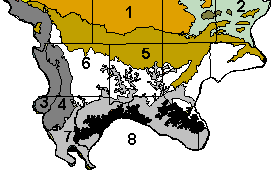
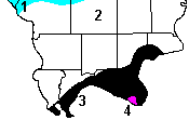
The area of southern Illinois covered in this study is bordered on the west by the Mississippi River and on the north by the northern boundaries of Jackson, Williamson, Saline, and Gallatin counties. The study area is bordered on the south by the Ohio River and on the east by the Wabash River. This area includes the 11 counties of Alexander, Gallatin, Hardin, Jackson, Johnson, Massac, Pope, Pulaski, Saline, Union, and Williamson. The Shawnee Hills, located in the Interior Low Plateau Province, comprise half of Jackson County and most of Union, Johnson, Pope, and Hardin Counties (Voigt and Mohlenbrock 1964). Rainfall varies throughout the study area (Figure 2) as well as temperature (Table 2). Most of southern Illinois escaped glaciation during the Wisconsin Glacial Episode (Figure 3).
![]()
Figure 1. Physiographic regions in southern Illinois (adapted from IL DNR. 2003). 1 = Southern Till Plain Division, Mt. Vernon Hill Country Section. 2 = Wabash Border Division, Bottomlands Section. 3 = Lower Mississippi River Bottomlands Division, Southern Section. 4 = Ozark Division, Southern Section. 5 = Interior Low Plateaus Province, Greater Shawnee Hills Section. 6 = Interior Low Plateaus Province, Lesser Shawnee Hills Section. 7 = Coastal Plain Division, Bottomlands Section. 8 = Coastal Plain Division, Cretaceous Hills Section.
![]()
Figure 2. Annual precipitation (mm) in southern Illinois from 1961-1990 (adapted from Oregon State University 2000). 1 = 1067-1118; 2 = 1118-1168; 3 = 1168-1219; 4= above 1219.
![]()
Table 2. Ranges in temperature and precipitation data from weather stations in Alabama (3), Arkansas (11), Illinois (37), Indiana (18), Kentucky (15), Mississippi (12), Missouri (38) and Tennessee (32)(Data from Buttle and Tuttle 1996-2003).
|
Province |
|
PRECIPITATION |
TEMPERATURE |
|
|
|
|
|
Section |
Elevation (m) |
Average Annual (mm) |
Average Annual (° C) |
Average Maximum (° C) |
Average Minimum (° C) |
Average Minimum January (° C) |
Av Max July (° C) |
|
Central Lowland Plateaus |
|
|
|
|
|
|
|
|
Till Plains |
111-219 |
901.2-1130.1 |
11.3-14.2 |
16.9-20.5 |
5.4-7.9 |
-0.3 to-6.1 |
30.3-32.9 |
|
Coastal Plain |
|
|
|
|
|
|
|
|
East Gulf Coastal Plain |
67-160 |
1111.8 -1521.6 |
14.0-16.8 |
19.7-23.4 |
6.8-10.6 |
0.2 to -4.7 |
31.8-33.3 |
|
Mississippi Alluvial Plain |
65-176 |
1108.0-1393.8 |
13.4-16.6 |
19.7-22.5 |
7.0-11.2 |
-0.3 to -6.1 |
25.2-27.6 |
|
Ozarks Plateau |
|
|
|
|
|
|
|
|
Springfield-Salem Plateaus |
100-402 |
976.3-1216.5 |
11.8-14.2 |
18.4-21.4 |
4.2-9.1 |
-3.9 to -9.2 |
31.2-33.3 |
|
Interior Low Plateaus |
|
|
|
|
|
|
|
|
Highland Rim |
115-265 |
1078.3-1434.1 |
11.8-16.1 |
17.5-22.7 |
5.4-10.1 |
-0.5 to -7.2 |
24.0-26.3 |
![]()
Figure 3. Glaciated areas in southern Illinois during the Wisconsin Glacial Episode (adapted from Abert 2003).

![]()
METHODS
Documentation
Sites that had been documented in the past for having supported populations of endangered plant species were visited during the summer of 2002. New sites supporting endangered species were documented and their locations determined through GPS readings. Four or more readings were taken at each of the sites that formed distinct patches. One GPS reading was determined for scattered individuals and all of the readings were incorporated into the Illinois Department of Natural Resources Database. A series of different sampling methods were used at each of the sites to determine specific abiotic and biotic attributes. Fieldwork was with a subset of 15 of the 97 endangered plants of southern Illinois and it has generated data on geographical, abiotic and biotic characteristics not found in the literature. In addition, five Illinois threatened and three Forest sensitive species were included in this study.
Species studied
Twenty-three rare species were included in this study with 15 listed as Illinois endangered (E), five as Illinois threatened (T), and three as Forest Sensitive (FS). Rare species that were known from the fewest locations and having a common congenitor were chosen to represent the rare species of southern Illinois. Other species were added to the study when discovered. In addition, other rare species were included in the study utilizing individuals having local knowledge of site locations. Twenty-three common species of plants from the same genera as the rare ones were used for comparison purposes (Table 3). Soil samples and seed were collected in all of the 11 counties of southern Illinois.
![]()
Table 3. Common and rare species studied. Common species are unmarked, E = endangered in Illinois; FS = forest sensitive; T = threatened in Illinois.
|
Apiaceae |
|
|
|
Eryngium prostratum Nutt. ex DC. (E) |
|
|
Eryngium yuccifolium Michx. |
|
|
Sanicula canadensis L. |
|
Sanicula smallii Bickn. (FS) |
|
|
Asclepiadiaceae |
|
|
|
Matelea gonocarpos (Walt.) Shinners |
|
|
Matelea obliqua (Jacq.) Woods. (T.) |
|
Asteraceae |
|
|
|
Echinacea simulata R.L. McGregor (FS) |
|
Caryophyllaceae |
|
|
|
Silene ovata Pursh. (E) |
|
|
Silene stellata (L.) Ait. f. |
|
Cyperaceae |
|
|
|
Carex carolineana Schwein. |
|
|
Carex decomposita Muhl. (E) |
|
|
Carex digitalis Willd. |
|
|
Carex gigantea Rudge (E) |
|
|
Carex grayi Carey |
|
|
Carex hirsutella MacKenzie |
|
|
Carex lupulina Willd. |
|
|
Carex lurida Wahlenb. |
|
|
Carex oxylepis Torr. & Hook. (T) |
|
|
Carex rosea Willd. |
|
|
Lipocarpha maculata (Michx.) Torr. (E) |
|
Dennstaedtiaceae |
|
|
|
Dennstaedtia punctilobula (Michx.) T. Moore (E) |
|
Fabaceae |
|
|
|
Amorpha fruticosa L. |
|
|
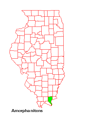
Amorpha nitens Boynt. (E) |
|
Fagaceae |
|
|
|
Quercus ×bushii Sarg. |
|
|
Quercus marilandica Muenchh. |
|
|
Quercus muehlenbergii Engelm. |
|
|
Quercus palustris Muenchh. |
|
|
Quercus phellos L. (T) |
|
|
Quercus prinus L. (T) |
|
|
Quercus rubra L. |
|
|
Quercus stellata Wangenh. |
|
|
Quercus texana Buckl. (E) |
|
|
Quercus velutina Lam. |
|
Gentianaceae |
|
|
|
Bartonia paniculata(Michx.) Muhl. (E) |
|
Lamiaceae |
|
|
|
Salvia azurea Lam. (T) |
|
|
Salvia lyrata L. |
|
Pinaceae |
|
|
|
Pinus echinata P. Mill. (E) |
|
Plantaginaceae |
|
|
|
Plantago cordata Lam. (E) |
|
|
Plantago rugelii Dcne. |
|
Poaceae |
Calamagrostis porteri Gray ssp. insperata (Swallen) C.W. Greene (E) |
|
|
Dichanthelium boscii (Poir.) Gould & C.A. Clark |
|
|
Dichanthelium ravenelii (Scribn. & Merr.) Gould (E) |
|
Primulaceae |
|
|
|
Dodecatheon frenchii (Vasey) Rydb. (FS) |
|
|
Dodecatheon meadia L. |
|
Pyrolaceae |
|
|
|
Chimaphila maculata (L.) Pursh (E) |
|
Saxifragaceae |
|
|
|
Saxifraga virginiensis Michx. (E) |
![]()
Field methods
Populations of endangered species were located, delineated, divided into thirds, and a soil sample was extracted from the center of each third. In most cases the number of individuals at the individual sites were small in number and grouped closely together. Samples were extracted from the top 7-10 cm of the A horizon eschewing the litter layer. The hydrometer method was used to quantitatively determine the per cent sand, silt, and clay. A 1:1 paste was made of the samples to measure the pH and conductivity, i.e., ion content. The soil samples collected were also tested for organic matter by first weighing them after air drying, and then weighing them again after putting them into a Thermolyne basic large-chamber muffle furnace at 450°C for seven hours. The difference in weight yields the percent organic carbon. Samples were run again a second time at 850°C, and the difference in weights represents the inorganic carbon or bicarbonate content. Soils that have a pH of 5.5 or lower are acidic and can not have bicarbonate. The soil pH of both common and rare species was determined and classified (Table 4). County soil survey maps were utilized in identifying and analyzing the soil found at each population site. In addition slope and aspect were determined at each site (Table 5). Slope was calculated through the use of a tape measure, a 1-m rule, and a level. Aspect was noted and checked on topographic maps. The slope aspect was transformed with A' = cos(45-Asp) + 1, where Asp is degrees (azimuth). With this transformation, the index aligns itself on a SW to NE axis and can be used as an approximation of radiation load. A convex spherical densiometer was used to determine canopy cover at each of the sites (Table 6). Four readings at 90° intervals were taken at the center of each site. The results of the measurements and observations taken at each site are included in the individual species reports. Species descriptions and general habitat were derived from the literature (Gleason and Cronquist 1995) and from the Internet (Iverson et al. 1999). National distribution maps, scientific names, common names, families, and listing status in other states for the rare species included in this study are from the Plants Database (USDA, NRCS. 2002). Maps depicting the distribution of the rare species in Illinois were derived from the Illinois Plant Information Network (Iverson et al. 1999). The Habitat in Southern Illinois sections of the Individual Species Reports was derived from field and laboratory work conducted in 2002 and 2003. GPS readings were utilized in locating species sites on TopoZone (1999-2003). The classification of soil into an Illinois soil series was done through comparing soil test results coupled with reference to maps found in the Soil Survey books by the Soil Conservation Service and the Illinois Agricultural Experiment Station. The statistical treatment of the measurements and observations are to be found in Chapter three of my thesis.\
![]()
Table 4.Terminology and pH range classes (Fitzpatrick 1986).
|
TERMINOLOGY |
RANGE IN pH |
|
Extremely acid |
< 4.5 |
|
Very strongly acid |
4.5-5.0 |
|
Strongly acid |
> 5-5.5 |
|
Medium acid |
>5.5-6.0 |
|
Slightly acid |
>6.0-6.5 |
|
Mildly alkaline |
> 6.5-7.3 |
|
Neutral |
>7.3-7.8 |
|
Moderately alkaline |
>7.8-8.5 |
|
Strongly alkaline |
>8.5-9.0 |
|
Very strongly alkaline |
>9.0 |
![]()
Table 5. Slope class terminology and percent slope (Ontario Centre for Soil Evaluation 1993).
|
Slope class |
Percent slope |
Terminology |
|
1 |
0-0.5 |
level |
|
2 |
>0.5-2 |
nearly level |
|
3 |
>2-5 |
very gentle slopes |
|
4 |
>5-10 |
gentle slopes |
|
5 |
>10-15 |
moderate slopes |
|
6 |
>15-30 |
strong slopes |
|
7 |
>30-45 |
very strong slopes |
|
8 |
>45-70 |
extreme slopes |
|
9 |
>70-100 |
steep slopes |
|
10 |
> 100 |
very steep slopes |
![]()
Table 6. Densiometer readings and class.
|
Shade Class |
Densiometer Reading (%) |
Descriptive Terminology |
|
1 |
0-20 |
Full sun |
|
2 |
>20-40 |
Moderate sun |
|
3 |
>40-60 |
Half shade |
|
4 |
>60-80 |
Moderate shade |
|
5 |
>80-100 |
Full shade |
![]()
Individual species Reports
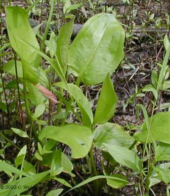
Amorpha nitens Boynt.
Fabaceae
Status in Illinois: endangered
Description
Shrub 1-4 m; leaves pinnately compound; leaflets oblong-ovate, 2-6 cm long, shining above, with entire margins, blackening in drying; flowers five-merous, blue, irregular, in dense spike-like racemes from the upper leaf axils and terminal.
Distribution
This species is at its northern-most limit in Illinois. It is not endangered or threatened in Alabama, Arkansas, Georgia, Kentucky, Louisiana, Oklahoma, South Carolina, or Tennessee.


General Habitat
Along upper drainageways, thickets, borders of lakes, and streambanks.
Habitat in Southern Illinois
Amorpha nitens occurs on west-facing, strong slopes along a drainageway at the Pope county site in loam soil that is neutral in pH. The soil at this site is a Grantsburg silt loam even though it contained only 44% silt instead of the required >50%. This discrepancy may be due to the proximity of the site to a highway. Species providing moderate shade at the site include Carya spp., Cercis canadensis, and Platanus occidentalis. There were a total of 16 plants at this site on August 3, 2002 with three of these bearing fruit. The seeds were collected during this visit and were not viable. Plant heights ranged from 15-114 cm with an average height of 47 cm. Most of the area in and around the site was bare ground (60%) with woody groundcover (35%) dominating over herbaceous (5%).
![]()
Bartonia
paniculata (Michx.) Muhl.twining screwstem
Gentianaceae
Status in Illinois: endangered
Description
Scrambling annual or biennial vine to 20-40 cm in length; leaves scale-like, mostly alternate with the lower leaves sometimes opposite; panicles 5-10 cm long; flowers white, four-merous, complete, and regular; fruit a capsule.
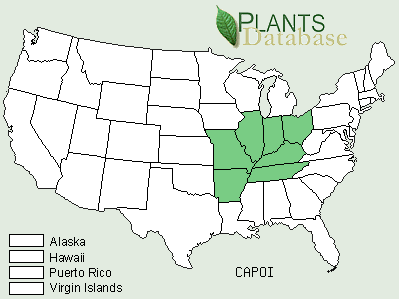
Distribution
Bartonia paniculata is at the northwestern range of its distribution in Illinois. It is listed as endangered in New York and as threatened in Michigan and Maine. Twining screwstem is also found in Alabama, Arkansas, Connecticut, Delaware, Florida, Georgia, Kentucky, Louisiana, Maryland, Massachusetts, Mississippi, Missouri, New Hampshire, New Jersey, North Carolina, Oklahoma, Pennsylvania, Rhode Island, South Carolina, Tennessee, Texas, and Virginia.
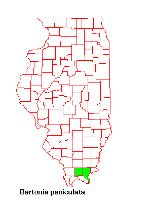

General Habitat
Sand and acid gravel seeps and springs; swamps, bogs, and wet meadows.
Habitat in Southern Illinois
Bartonia paniculata occurs on south-facing, gentle slopes at the Pope county site in sandy loam soil that is very strongly acidic. The soil in this area is a Hosmer silt loam. In many instances B. paniculata occurs in clumps of moss and it is difficult to find before the fall when it flowers. Fifteen to twenty plants were blooming on October 5, 2002 along the edge of the water where the seep spring resurfaced. Species providing full shade at this site include Quercus rubra, Acer rubrum, and Liriodendron tulipifera. Other species at the site included Carex lurida, Juncus effusus, J. interior, and Panicum flexile. There is virtually no woody groundcover at this site.
![]()
Calamagrostis
porteri Gray ssp. insperata (Swallen) C.W. GreenePorter's reedgrass
Poaceae
Status in Illinois: endangered.
Description
Culms up to 1 m in height, from creeping rhizomes; leaf blades up to 12 mm wide, light green and glaucous on both upper and lower surfaces; sheath collar glabrous; ligule 2-5 mm; panicle 10-20 cm long, branches are fascicled and spreading.
Distribution
Calamagrostis porteri ssp. insperata is at its northern range of its. distribution in Illinois. It is listed as endangered in Arkansas, Kentucky, and Ohio and as threatened in Indiana. Porter's reedgrass is also found in Missouri and Tennessee.

General Habitat
Dry, rocky woods.
Habitat in Southern Illinois
Porter's reedgrass was growing on north- and northeast-facing, strong slopes at the two Pope county sites in silt loam and loam soil respectively. The soil at both sites is very strongly acidic and is classified as Sandstone Rock Land as it contains many boulders, rock outcrops, and vertical bluffs. The groundcover in and around the north-facing site was composed predominantly of herbaceous species (75%) with only 5% woody. Species providing moderate shade include Juniperus virginiana, Amelanchier arborea, and Diospyros virginiana. The other site has 70% bare ground with 25% woody and 5% herbaceous plants. Species providing full shade at this site includes Quercus alba and Carya spp. None of the plants observed were flowering or fruiting in 2002 or 2003.
![]()
Carex
decomposita Muhl.cypressknee sedge
Cyperaceae
Status in Illinois: endangered
Description
Stems clustered, 50-100 cm tall; leaf blades 5-8 mm wide; sheaths pale on underside, red-dotted and concave at the throat; staminate spike at the top of the inflorescence; perigynium black to deep olive-green, 2-2.8 mm long.
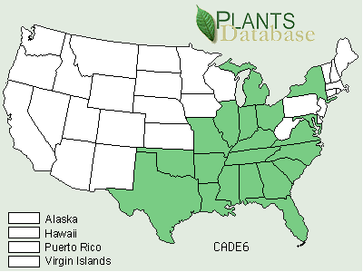
Distribution
Carex decomposita is at the northwestern edge of its range of distribution in Illinois. It is listed as endangered in New York and Ohio and as threatened in Indiana and Kentucky. It is probably extirpated in Maryland and Michigan. The cypressknee sedge is also found in Alabama, Arkansas, Florida, Georgia, Louisiana, Mississippi, Missouri, North Carolina, Oklahoma, South Carolina, Tennessee, Texas, and Virginia.
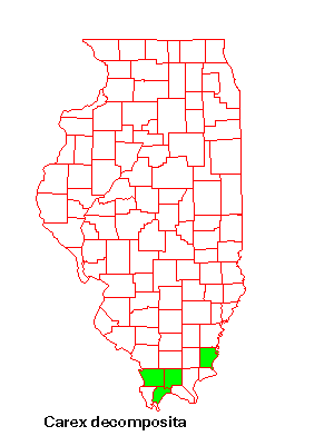
General Habitat
Swamps.
Habitat in Southern Illinois
Carex decomposita grows at the base of Acer rubrum, Taxodium distichum, and other wetland trees. The Karnak silt loam is very high in organic matter and neutral in pH. Seed production was prolific and on July 27, 2002 some seed was still remaining on the plant. None of the seed germinated in the greenhouse experiment and the tetrazolium test showed that it was not viable. Groundcover was 70% herbaceous and 30% woody along the edge of the swamp. Species providing full shade include Fraxinus pennsylvanica, Acer rubrum, and Taxodium distichum.
![]()
Carex
gigantea Rudgegiant sedge
Cyperaceae
Status in Illinois: endangered
Description
Stems solitary or clustered in small groups; 50-120 cm tall; rhizomes long, dark, scaly; leaf blades 5-16 mm wide, septate-nodulose; perigynia are spreading, shiny, smooth with prominent nerves and are 11-18 mm long and 4-6 mm wide;
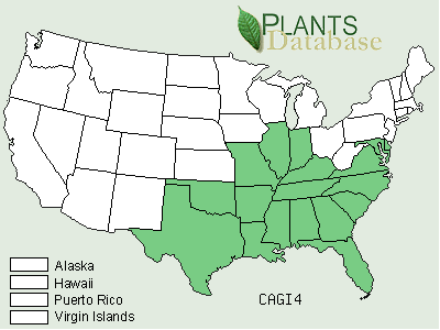
Distribution
Carex gigantea is at the northern edge of its national distribution in Illinois. It is listed as endangered in Indiana and as threatened in Kentucky. The giant sedge is also found in Alabama, Arkansas, Delaware, Florida, Georgia, Louisiana, Maryland, Mississippi, Missouri, North Carolina, Oklahoma, South Carolina, Tennessee, Texas, and Virginia.
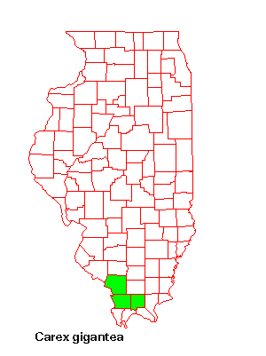
General Habitat
Floodplain forests and swamps.
Habitat in Southern Illinois
The giant sedge was growing on west-facing, strong slopes at the Pulaski site in silty clay loam soil that is neutral in pH. The soil at this site is in the Ginat Series and is located on a terrace that is associated with the Ohio River and the Cache River channel. Twenty plants were observed on August 14 at the site that were clumped closely together and all of these were fruiting. None of the seed germinated in the greenhouse experiment and the tetrazolium test showed that it was not viable. Groundcover was predominantly herbaceous (75%) around the site. Species providing full shade included Celtis occidentalis, Quercus alba, and Carya spp.
![]()
Carex
oxylepis Torr. & Hook.sharpscale sedge
Cyperaceae
Status in Illinois: threatened
Description
Stems clustered, 30-90 cm tall; leaves 3-5 mm wide, hairy beneath; leaf sheaths and the peduncles of the spike are also pubescent; uppermost spike peduncled; perigynia ovoid, 3.5-4.6 mm long, tapering into a short beak; pistillate scales usually not as wide or as long as the perigynia.
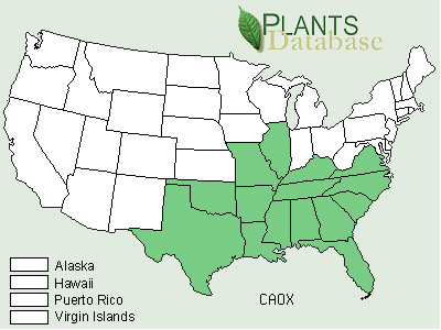
Distribution
Carex oxylepis is at the northwestern edge of its national distribution in Illinois. The sharpscale sedge is also found in Alabama, Arkansas, Florida, Georgia, Kentucky, Louisiana, Mississippi, Missouri, North Carolina, Oklahoma, South Carolina, Tennessee, Texas, and Virgini
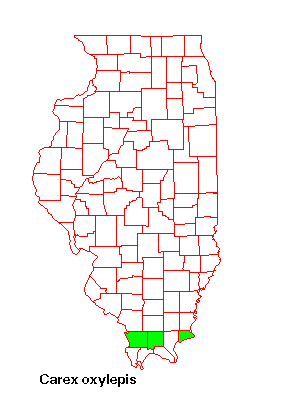
General Habitat
Wet to mesic floodplain forests and swamps
Habitat in Southern Illinois
Carex oxylepis grows on a southwest-facing, gentle slope at the Hardin County site in Alford silt loam soil that is strongly acidic in pH. Species providing half shade at this upland site included Cercis canadensis, Quercus alba, and Carya spp. In 2003 groundcover consisted of mostly woody species (50%) with herbaceous species contributing an additional 15%. It included Parthenocissus quinquefolia, Juniperus virginiana, Carex annectens, and Toxicodendron radicans.
![]()
Chimaphila
maculata (L.) Purshstriped prince's pine
Pyrolaceae
Status in Illinois: endangered
Description
Half-shrub 1-2 m; stems decumbent and rooting at the nodes; leaves opposite, striped with white along main vein, remotely, sharply toothed; flowers fragrant, in umbels of 2-5, with 5 pink or white petals; capsule depressed-globose.
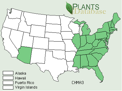
Distribution
This species is at its northwestern-most limit in Illinois. Chimaphila maculata is endangered in Maine and is exploitably vulnerable in New York. It is also found in Alabama, Arkansas, Georgia, Kentucky, Louisiana, Oklahoma, South Carolina, or Tennessee.
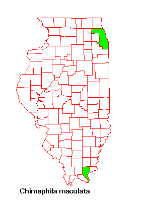
General Habitat
Sandy soil in dry upland forests.
Habitat in Southern Illinois
Chimaphila maculata occurs on northeast-facing, strong slopes at the Pope county site in loam soil. The soil at this site is very strongly acidic and is classified as Sandstone Rock Land as it contains many boulders, rock outcrops, and vertical bluffs. Species providing full shade include Quercus alba and Carya spp. There were a total of 12 plants at this site on June 25, 2003. Most of the area in and around the site was bare ground (60%) with woody groundcover (25%) dominating over herbaceous (5%).
![]()
Dennstaedtia punctilobula
(Michx.) T. Mooreeastern hayscented fern
Dennstaedtiaceae
Status in Illinois: endangered
Description
Fronds bipinnate-pinnatifid, 40-80 cm long and up to 25 cm wide with dark reddish-brown (basally) petiole 20 cm long; 17-25 pinnae are alternate or subopposite, lanceolate, 13 cm long, 4.5 cm wide and with a short petiole; 14-25 pinnules are subsessile, deeply pinnatisect with segments having 6-8 pairs that are ovate and with 2-3 oblique, sharp teeth on both sides.
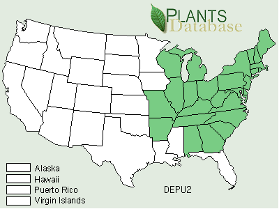
Distribution
Dennstaedtia punctilobula is also found in Alabama, Arkansas, Connecticut, Delaware, Georgia, Indiana, Kentucky, Maine, Maryland, Massachusetts, Missouri, New Hampshire, New Jersey, New York, North Carolina, Ohio, Pennsylvania, Rhode Island, South Carolina, Tennessee, Vermont, Virginia, West Virginia, and Wisconsin.
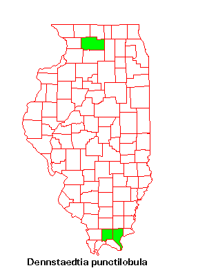
General Habitat
Open woods, clearings, rocky slopes and bluffs, and seasonal creekbeds.
Habitat in Southern Illinois
Dennstaedtia punctilobula grows on the outer edge of a seasonal, meandering creekbed. It was first observed in 2002 as a single plant with multiple fronds. Since the creekbed was no longer flowing on the outer edge, detritus had began to wash down and cover the fern from the adjoining moderate slope. This Pope County site has sandy soil that is medium acidic in pH and is included in the Saffell Soil Series. Groundcover was sparse and consisted of 20% woody and 10% herbaceous plants. Species providing full shade include Quercus alba, Ulmus americana, and Carya spp.
![]()
Dichanthelium
ravenelii (Scribn. & Merr.) GouldRavenel's rosette grass
Poaceae
Status in Illinois: endangered
Description
Culms 40-60 cm tall, sometimes purple, with spreading or ascending pubescence and the nodes densely so; ligule a ring of hairs 2.5-4 mm long; leaf blades up to 12 cm long and 18 mm wide, glabrous above, softly pubescent beneath; panicles 6-10 cm long, ovoid; basal leaves formed in fall.
Distribution
Dichanthelium ravenelii is at the northwestern edge of its national distribution in Illinois. Ravenel's rosette grass is also found in Alabama, Arkansas, Delaware, Florida, Georgia, Iowa, Kentucky, Louisiana, Maryland, Mississippi, Missouri, North Carolina, Oklahoma, South Carolina, Tennessee, Texas, and Virginia.
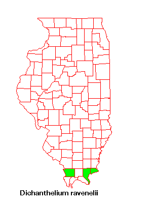
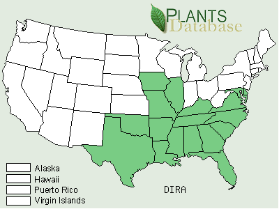
General Habitat
Dry upland forests, sandstone glades, sandstone cliffs (rocky bluffs)
Habitat in Southern Illinois
Dichanthelium ravenelii grows on a southwest-facing, strong slope at the Hardin County site in sandy loam soil. The soil is strongly acidic in pH and is part of the Sandstone Rock Land. On July 13, 2002 about 11 fruiting plants were observed. Groundcover was about 20% for both woody and herbaceous plants. Species providing full shade include Quercus alba, Juniperus virginiana, and Carya spp. Other species growing around the D. ravenelii at this site include Ulmus americana, Acer saccharum, and Toxicodendron radicans.
![]()
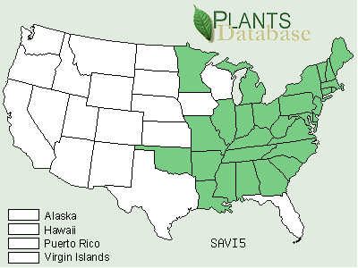
Dodecatheon
frenchii (Vasey) Rydb.French's shootingstar
Primulaceae
Status in Illinois: forest sensitive (IDNR)
Description
Perennial to 60 cm tall; leaves ovate, in a basal rosette, cordate or abruptly narrowing to the petiole; flowers in umbels, white, five-merous, nodding, on ascending or erect pedicels; capsules erect.
Distribution
Dodecatheon frenchii is at the northern edge of its national distribution in Illinois. It is listed as threatened in Arkansas, rare in Indiana, and of special concern in Kentucky. French's shootingstar is also found in Alabama.
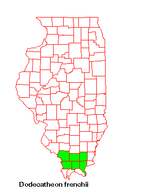
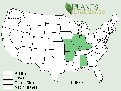
General Habitat
Shaded, overhangs of sandstone rock formations
Habitat in Southern Illinois
Dodecatheon frenchii grows on both east- and west-facing, very gentle and moderate slopes at the Jackson County sites in both sandy loam and clay loam soils respectively. The soil at the 2 sites is medium acid and very strongly acid in pH respectively. Both sites are classified as Sandstone Rock Land. In 2003 groundcover was predominantly herbaceous at both sites (40% and 20%) with an additional 10% woody plants at the former. Species providing full shade along with the rock outcrops include Acer saccharum, Liriodendron tulipifera, and Carya spp.
![]()
Echinacea
simulata R.L. McGregorwavyleaf purple coneflower
Asteraceae
Status in Illinois: forest sensitive (IDNR)
Description
Perennial herb with taproot; leaves simple, alternate, mostly toward base, 20 cm long, four cm wide, coarsely pubescent and with three main veins; ray flowers are pink to purple or white, about 13 per head, often drooping
Distribution
Echinacea simulata is at the northern edge of its national distribution in Illinois. It is listed as threatened in Tennessee. The wavyleaf purple coneflower is also found in Indiana, Kentucky, and Missouri.

General Habitat
Dry situations, especially in prairies.
Habitat in Southern Illinois
Echinacea simulata grows on mostly west-facing, very strong slopes at the Johnson County site in clay soil. The soil at both sites is moderately alkaline and is classified as Sandstone Rock Land as it contains many boulders, rock outcrops, and vertical bluffs. Plants were numerous with seed heads and achenes still attached when this prairie site was visited on August 5, 2002. None of the seed was viable. Echinacea simulata grows in full sun, but Juniperus virginiana provides some canopy cover. All of the groundcover was herbaceous and included Salvia azurea, and Silphium integrifolium.
![]()
Eryngium
prostratum Nutt. ex DC.creeping eryngo
Apiaceae
Status in Illinois: endangered
Description
Prostrate, fibrous-rooted perennial that roots at its nodes; leaves ovate to lanceolate, 1-4 cm long, entire or toothed; flowers blue violet, five-merous, complete, regular, in heads.
Distribution
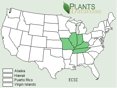
Eryngium prostratum is at its northern edge of its national distribution in southern Illinois. Other states include Alabama, Arkansas, Delaware, Florida, Georgia, Kansas, Kentucky, Louisiana, Mississippi, Missouri, North Carolina, Oklahoma, South Carolina, Tennessee, Texas, and Virginia.
General Habitat
Wet, muddy, sandy soil in floodplain forests, borders of lakes, and bogs.
Habitat in Southern Illinois
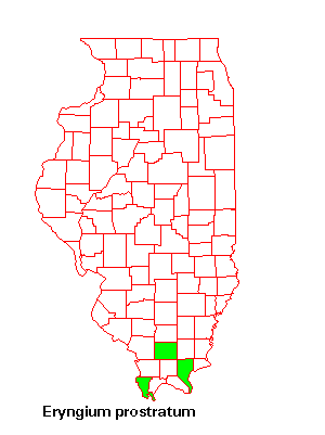
Eryngium prostratum grows on west-facing moderate slopes at the Massac County site in Belknap silt loam soil that is strongly acidic in pH. Species providing moderate shade include Quercus rubra and Carya spp. One-hundred percent of the groundcover is composed of herbaceous plants. Plants growing with it around the edge of the pond in 2002 included Eclipta alba, Eleocharis ovata, Eragrostis hypnoides, Fimbristylis autumnalis, Galium obtusa, Hypericum muticum, Lindernia dubia, and Lipocarpha maculata.
![]()
Lipocarpha
maculata (Michx.) Torr.American halfchaff sedge
Cyperaceae
Status in Illinois: endangered
Description
Cespitose annual growing up to 30 cm tall; achenes 1 mm long, not enclosed in a perigynia, subtended by two additional hyaline scales, adaxial one persistent on the rachilla, the abaxial scale is deciduous with the achene; bracts two or three; spikelets 3-7 mm long, with numerous green scales that turn brown with dark spots at maturity.
Distribution
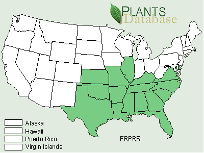
Lipocarpha maculata is at its northwestern edge of its national distribution in Illinois. Other states include Alabama, Florida, Georgia, New Jersey, North Carolina, Pennsylvania, South Carolina, and Virginia.
General Habitat
Wet, muddy, sandy soil in floodplain forests, borders of lakes, and bogs.
Habitat in Southern Illinois
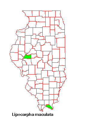
Lipocarpha maculata grows on west-facing moderate slopes at the Massac County site in Belknap silt loam soil that is strongly acidic in pH. Species providing moderate shade include Quercus rubra and Carya spp. One-hundred percent of the groundcover is composed of herbaceous plants. Plants growing with it around the edge of the pond in 2002 included Eclipta alba, Eleocharis ovata, Eragrostis hypnoides, Eryngium prostratum, Fimbristylis autumnalis, Galium obtusa, Hypericum muticum, and Lindernia dubia.
![]()
Matelea
obliqua (Jacq.) Woods.climbing milkvine
Asclepiadaceae
Status in Illinois: threatened
Description
Perennial vine; leaves opposite, simple, palmately veined, cordate, ovate to rotund; flowers in umbels, brownish-purple, 10-16 mm long, 1.5-2.5 mm wide.
Distribution
Matelea obliqua is at its northwestern edge of its national distribution in Illinois. It is classified as endangered in Maryland and Pennsylvania, threatened in Ohio, and rare in Indiana. Other states within the distribution include Alabama, Georgia, Kentucky, Mississippi, Missouri, North Carolina, Tennessee, Virginia, and West Virginia.
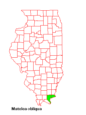
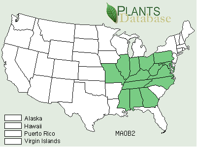
General Habitat
Rocky woods, thickets, and limestone glades.
Habitat in Southern Illinois
The climbing milkvine grows on slopes that range from moderate to strong, in sandy loam (1), clay loam (1) or clay (3) soils. Most soils (3) were near neutral, but can be very strongly acidic (1), or mildly alkaline (1). Four out of the five sites are southeast-facing with another one east-facing. All of the sites are probably in Sandstone Rock Land, but maps do not always indicate it. Groundcover varied widely between the five sites in 2003 with herbaceous plants ranging from 10-85% and woody plants ranging from 5-75%. Species providing canopy cover included Quercus alba, Quercus velutina, Carya spp., Acer saccharum, and Juniperus virginiana.
![]()
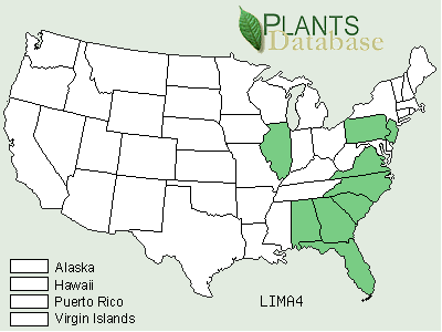
Pinus
echinata P. Mill.shortleaf pine
Pinaceae
Status in Illinois: endangered.
Description
Evergreen tree to 35 m; twigs light in color, glaucous; leaves in clusters of twos or threes, 7-12 cm long; pine cones divergent, 4-6 cm long, with terminal, 1-2 mm long spines.
Distribution
Pinus echinata is at its northwestern edge of its national distribution in Illinois. Other states within its distribution include Alabama, Arkansas, Delaware, Florida, Georgia, Kentucky, Louisiana, Maryland, Mississippi, Missouri, New Jersey, New York, North Carolina, Ohio, Oklahoma, Pennsylvania, South Carolina, Tennessee, Texas, Virginia, and West Virginia.
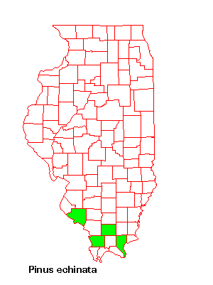
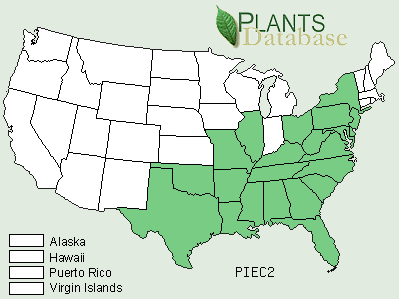
General Habitat
Dry upland forests in sandy or rocky soil.
Habitat in Southern Illinois
Pinus echinata grows on southwest-facing, strong slopes, in Alford silt loam, that is strongly acidic. Groundcover grows in full shade and is primarily woody (98%) with virtually no bare ground. Other tree species growing alongside the shortleaf pine at the Union county site in 2003 included Quercus rubra, Carya spp. and Fagus grandifolia.
![]()
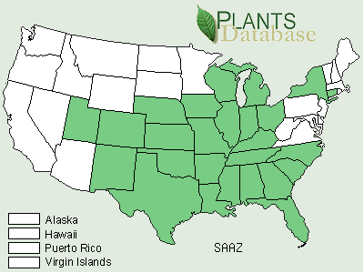
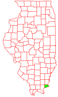
Plantago
cordata Lam.heartleaf plantain
Plantaginaceae
Status in Illinois: endangered.
Description
Perennial from fleshy roots that are 0.5-1.3 cm thick; leaves basal, cordate-ovate, up to 25 cm long and 20 cm wide; flowers white. 4-merous, in spikes; capsules ovoid, 5-10 mm long.
Distribution
Plantago cordata is listed as endangered in Indiana, Michigan, Kentucky, Maryland, North Carolina, Tennessee, and Wisconsin and as threatened in Arkansas, New York and Ohio. Other states within its distribution include Alabama, Florida, Georgia, Iowa, Mississippi, Missouri, North Carolina, South Carolina, and Virginia.
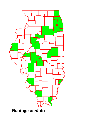
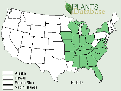
General Habitat
Wet floodplain forests, seeps, springs, marshes, and along streams.
Habitat in Southern Illinois
The heartleaf plantain grows on gentle to very gentle slopes, in silt loam (2) or sandy loam (1), that ranges from near neutral to medium acid in pH. The aspects at the three sites were northeast, southeast, and southwest. Plantago cordata at all three sites were located within seasonal creekbeds. Two of the sites are in close proximity to lakes and had no woody groundcover or bare ground. The third site is located at the base of a prairie and also did not have any woody groundcover. However, 85% of the ground was bare, largely due to the rocky nature of the creekbed. One of the lake sites was under water when visited on June 6, 2003. Tree species offering canopy cover to Plantago cordata at the Jackson county sites and the Johnson county site included Platanus occidentalis, Acer saccharum, Fraxinus pennsylvanica, Ulmus americana, and Carya spp. The three sites ranged from moderate shade to moderate sun.
![]()
Quercus phellos
L.willow oak
Fagaceae
Status in Illinois: threatened
Description
Shrub or small tree to 25 m in height; leaves entire, oblong linear to lanceolate/oblanceolate shaped, dull green on the underside, shiny green above, bristle-tipped, up to 12 cm long and 2 cm wide.
Distribution
Quercus phellos is at the northern edge of its national distribution in Illinois. The willow oak is on the endangered list in New York and Pennsylvania. It is also found in Alabama, Arkansas, Connecticut, Delaware, Florida, Georgia, Kentucky, Louisiana, Maryland, Mississippi, Missouri, New Jersey, North Carolina, Oklahoma, South Carolina, Tennessee, Texas, and Virginia.
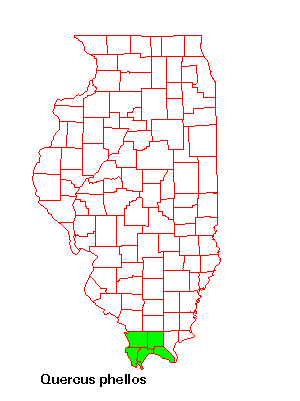
General Habitat
Bottomlands, swamps, and moist soil.
Habitat in Southern Illinois
The willow oak were growing on level ground at the Massac County site in Karnak silty clay loam that is slightly acidic in pH. Herbaceous plants composed 15% of the groundcover with woody plants contributing another 60 percent. About 17% of the acorns collected in 2002 germinated in the greenhouse experiment. Species providing canopy cover included Celtis occidentalis, Quercus palustris, and Quercus lyrata. Other species growing in full shade in the mixed bottomland forest site included Brunnichia cirrhosa, Populus heterophylla, Iris fulva, Trachelospermum difforme, and Diospyros virginiana.
![]()
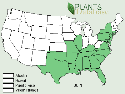
Quercus prinus
L.chestnut oak
Fagaceae
Status in Illinois: threatened
Description
Tree to 30 m in height; leaves entire, oblong obovate, oblong, or ovate in shape, margins with 10-15 teeth per edge, up to 11 cm wide; acorn 2-2.5 cm wide.
Distribution
Quercus prinus is at the northern edge of its national distribution in Illinois. The chestnut oak is on the threatened list in Maine. It is also found in Alabama, Connecticut, Delaware, Georgia, Indiana, Kentucky, Louisiana, Maryland, Massachusetts, Michigan, Mississippi, New Hampshire, New Jersey, New York, North Carolina, Ohio, Pennsylvania, Rhode Island, South Carolina, Tennessee, Vermont, Virginia, and West Virginia.
General Habitat
Dry or moist soil of upland or rocky woods.
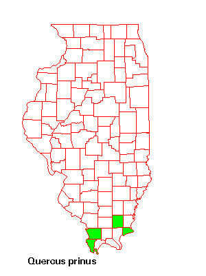
Habitat in Southern Illinois
Chestnut oak grow on east-facing, extreme slopes at the Union County site in Goss silt loam soil that is slightly acidic in pH. There were probably other aspects where Quercus prinus was located in this large wooded area with numerous ridges. Only 5% of the groundcover was composed of herbaceous species in 2002 with the balance made up of woody plants. Other tree species providing full shade include Quercus rubra, Juglans nigra, and Sassafras albidum. Other species growing around the site included Bromus kalmii.
![]()
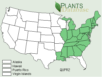
Quercus texana
Buckl.Texas red oak
Fagaceae
Status in Illinois: endangered
Description
Tree to 28 m in height; leaves entire, up to 19 cm long, 5-9 lobed, cut one-half to three-fourths of the way to the midrib, lobe bristles with 3-6 awns, not bristled right at tip; acorns 2-3 cm long.
Distribution
Quercus texana is at the northern edge of its national distribution in Illinois. The Texas red oak is also found in Alabama, Arkansas, Kentucky, Louisiana, Mississippi, Missouri, Tennessee, Texas.
General Habitat
Mesic to hydric bottomland sites that are poorly drained, with seasonal inundation by water.
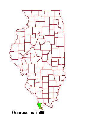
Habitat in Southern Illinois
Texas red oak were growing on south-facing and east-facing , nearly level and very gentle slopes at the Alexander County sites in Karnak silty clay or Cape silty clay loam soil that is strongly acidic or medium acidic in pH (respectively). Fifty-five to 80 percent of the ground cover was herbaceous at the two sites with an additional 5-10 percent woody species. These species grew in full shade. There were at least 6-10 trees at each of the two sites in 2002. Acorns were searched for on three different occasions and none could be found. Species providing canopy cover at the sites included Acer rubrum, Carya spp., Liquidambar styraciflua, and Taxodium distichum.
![]()
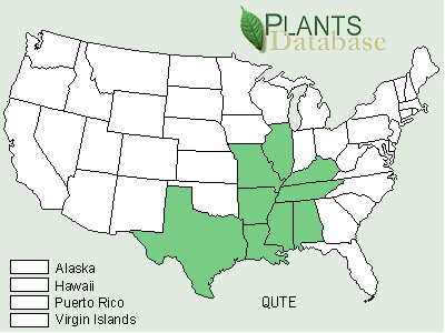
Salvia
azurea Michx. ex Lam.azure blue sage
Lamiaceae
Status in Illinois: threatened
Description
Perennial; stems covered with a gray-white pubescence; leaves simple, entire, opposite, toothed, linear oblong to lanceolate; flowers are arranged in a spike; flowers blue, irregular, five-merous, with 6-20 at each node.
Distribution
The azure blue sage is also found in Alabama, Arkansas, Colorado, Connecticut, Florida, Georgia, Indiana, Iowa, Kansas, Kentucky, Louisiana, Michigan, Mississippi, Missouri, Nebraska, New Mexico, New York, North Carolina, Ohio, Oklahoma, South Carolina, Tennessee, Texas, Utah and Wisconsin.
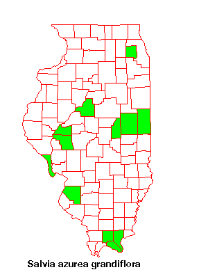
General Habitat
Prairies classified as Rocky Sandstone Land, roadsides, and waste ground.
Habitat in Southern Illinois
Salvia azurea grows on west-facing, very strong slopes at the Johnson County Sandstone Rock Land site in clay soil that is moderately alkaline in pH. There is virtually no bare ground at this prairie site and 100% of the groundcover is herbaceous. None of the seed collected in 2002 proved to be viable. There are numerous rocky outcrops at this site. Salvia azurea grows in full sun, but species providing canopy cover included Quercus rubra and Quercus alba. Other species growing nearby included Echinacea simulata, and Silphium integrifolium.
![]()
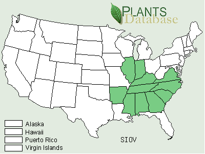
Sanicula
smallii Bickn.Apiaceae
Status in Illinois: endangered? Not thought to occur in Illinois.
Description
Perennial with cord-like roots; leaves three-parted with the lateral segments deeply lobed; flowers white; Ovoid fruit 3-5 mm long with its bristles longer than an individual sepal or style.
Distribution
Small's blacksnakeroot is listed as rare in Indiana. Sanicula smallii is also found in Alabama, Arkansas, Florida, Georgia, Kentucky, Louisiana, Mississippi, Missouri, North Carolina, South Carolina, Tennessee, Texas, Virginia, and West Virginia.
General Habitat
Rich woods
Habitat in Southern Illinois
Sanicula smallii was growing on south-facing, moderate slopes at the Hardin County site in Alford silt loam soil that is medium acid in pH. Groundcover at this mesic forest site with pine needle litter was primarily woody (75%). About 11 plants were observed on July 13, 2002 with the seed dispersing. None of this seed was viable. Species providing full shade include Pinus echinata, Cornus florida, and Juniperus virginiana.
![]()
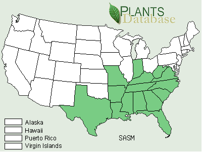
Saxifraga virginiensis
Michx.early saxifrage
Saxifragaceae
Status in Illinois: endangered.
Description
Perennial up to 40 cm in height; leaves in a basal rosette, oblong or ovate in shape, 2-5 cm long, entire or serrate, purplish on undersides; petals five-merous, white, 4-6 mm long.
Distribution
Saxifraga virginiensis is listed as rare in Indiana. The early saxifrage is also found in Alabama, Arkansas, Connecticut, Delaware, Georgia, Kentucky, Louisiana, Maine, Maryland, Massachusetts, Michigan, Minnesota, Mississippi, Missouri, New Hampshire, New Jersey, New York, North Carolina, Ohio, Oklahoma, Pennsylvania, Rhode Island, South Carolina, Tennessee, Vermont, Virginia, and West Virginia..
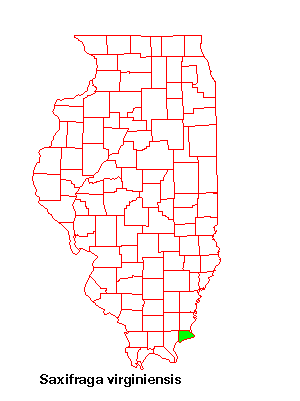
General Habitat
Moist or dry open woods and edges of sandstone rock-ledges.
Habitat in Southern Illinois
Early saxifrage grows on southeast and southwest facing, steeply sloped rock faces of the sandstone formations at the Hardin County site in loam/sandy loam soil that is medium acid in pH. Forty percent of the groundcover was herbaceous, mostly moss species, and an equal amount was composed of woody plants. Seed matures very early for this and none was found or collected on July 13, 2002 when the site was visited. Species providing moderate shade include Quercus alba and Carya spp.
![]()
Silene
ovata PurshCaryophyllaceae
Status in Illinois: endangered.
Description
Perennial up to 150 cm in height; leaves sessile, ovate to broadly lanceolate, up to 12 cm long, eight cm wide; petals white, their blades 7-9 mm long and with dissected with eight linear segments; three styles.
Distribution
Silene ovata is listed as endangered in Indiana and Tennessee and as threatened in Arkansas and Kentucky. The Blue Ridge catchfly is also found in Alabama, Georgia, Mississippi, North Carolina, South Carolina, and Virginia.
General Habitat
Woods
Habitat in Southern Illinois
Silene ovata was growing on southeast-facing, very strong slopes at the Hardin County site in sandy loam soil. The soil at this site is medium acidic in pH and is classified as Sandstone Rock Land as it contains many boulders, rock outcrops, and vertical bluffs. Twenty percent of the groundcover around the site was herbaceous and 30% of it was woody species. None of the seed collected in 2002 was viable. Species providing moderate shade include Cornus florida, Quercus rubra, and Carya spp.
![]()
Literature Cited
Abert, Curtiss. 2003. Modeling glaciated terrains. Internet access: http://gis.esri.com/library/userconf/proc96/TO100/PAP061/P61.HTM
Bazzaz, F. A. 1968. Succession on abandoned fields in the Shawnee Hills, southern Illinois. Ecology 49(5): 924-936.
Buchele, D. E., Baskin, J. M, and Baskin, C. C. 1989. Ecology of the endangered species Solidago shortii. I Geography, populations, and physical habitat. Bulletin of the Torrey Botanical Club 116: 344-355.
Buchele, D. E., Baskin, J. M, and Baskin, C. C. 1991a. Ecology of the endangered species Solidago shortii. II Ecological life cycle. Bulletin of the Torrey Botanical Club 118: 281-287.
Buchele, D. E., Baskin, J. M, and Baskin, C. C. 1991b. Ecology of the endangered species Solidago shortii. III Seed germination ecology. Bulletin of the Torrey Botanical Club 118: 288-291.
Buttle and Tuttle. 1996-2003. World Climate. http://www.worldclimate.com/
Cadotte, M. W. and Lovett-Doust, J. 2001. Ecological and taxonomic differences between native and introduced plants of Southwestern Ontario. Ecoscience 8: 230-238.
Committee on Resources, U.S. House of Representatives. 1997. Endangered Species Act of 1973. (http://resourcescommittee.house.gov/105cong/reports/105 c/esaidx.htm).
Costin, B. J., Morgan, J. W., and Young, A. G. 2001. Reproductive success does not decline in fragmented populations of Leucochrysum albicans subsp. albicans var. tricolor (Asteraceae). Biological Conservation 98: 273-284.
Ferdy, J., Loriot, S., Sandmeier, M., Lefranc, M., and Raquin, C. 2001. Inbreeding depression in a rare deceptive orchid. Canadian Journal of Botany 79: 1181-1188.
Fitzpatrick, E. A. 1986. An introduction to soil science. Second edition. Addison-Wesley Longman, Limited, England. 255 pages.
Garcia, M. B., Guzman, D., and Goni, D. 2002. An evaluation of the status of five threatened plant species in the Pyrenees. Biological Conservation 103: 151-161.
Gerakis, A., and Baer, B. 1999. A computer program for soil textural classification. Soil Science Society of America Journal 63:807-808. (http://nowlin.css.msu.edu/software/triangle_form.html).
Gleason, H. A., and Cronquist, A. 1995. Manual of vascular plants of northeastern United States and adjacent Canada. New York Botanical Garden. Bronx, New York.
Grime, J. P. 1974. Vegetation classification by reference to strategies. Nature 250: 26-31.
Grime, J. P. 1977. Evidence for the existence of three primary strategies in plants and its relevance to ecological and evolutionary theory. America Naturalist 111: 1169-1194.
Groppe, K., Steinger, T., Schmid, B., Baur, B., and Boller, T. 2001. Effects of habitat fragmentation on choke disease (Epichloë bromicula) in the grass Bromus erectus. Journal of Ecology 89: 247-255.
Heinlen, E. R. and Vitt, D. H. 2003. Patterns of rarity in mosses of the Okanogan Highlands of Washington state: an emerging coarse filter approach to rare moss conservation. The Bryologist 106: 34-52.
Hosner, J. F. and Minckler, L. S. Bottomland hardwood forests of southern Illinois--regeneration and succession. Ecology 44(1): 29-41.
IL DNR. 2002. The Illinois Endangered Species Protection Board. 524 South Second St., Springfield, IL, 62702. Internet Access: http://dnr.state.il.us/espb/datelist.htm.
IL DNR. 2003. Illinois Department of Natural Resources. Division of Education, One Natural Resources Way, Springfield, IL 62702-1271. Internet Access: http://dnr.state.il.us/lands/education/biodiversity/images/nat_div.GIF
Illinois Endangered Species Protection Board. 1994. Checklist of endangered and threatened animals and plants of Illinois.
Iverson, L.R., D. Ketzner, and J. Karnes. 1999. Illinois Plant Information Network. Database at http://www.fs.fed.us/ne/delaware/ilpin/ilpin.html. Illinois Natural History Survey and USDA Forest Service.
Jackson, S. T. 1983. Paleoecology of a fossil plant assemblage from a pre-Wisconsinan till in southern Illinois. The American Midland Naturalist 109: 120-135.
Jarosz, A. M. and Davelos, A. L. 1995. Tansley Review No. 81. Effects of disease in wild plant populations and the evolution of pathogen aggressiveness. New Phytologist 129(3): 371-387.
Kammerand, J. W. and Brewer, R. 1963. Dispersal rate and elm density as factors in the occurrence of Dutch Elm Disease. American Midland Naturalist 70(1): 159-163.
Kéry, M., Matthies, D., and Fischer, M. 2001. The effect of plant population size on the interactions between the rare plant Gentiana cruciata and its specialized herbivore Maculinea rebeli. Journal of Ecology 89: 418-427.
Kéry, M., Matthies, D., and Spillman, H. 2000. Reduced fecundity and offspring performance in small populations of the declining grassland plants Primula veris and Gentiana lutea. Journal of Ecology 88: 17-30.
Kunin, W. E. and Shmida, A. 1997. Plant reproductive traits as a function of local, regional, and global abundance. Conservation Biology 11(1): 183-192.
Layne, J. N. 1958. Notes on mammals of southern Illinois. American Midland Naturalist 60(1): 219-254.
Lee, T. D. 1989. Patterns of fruit and seed production in a Vermont population of Cassia nictitans L. (Caesalpiniaceae). Bulletin of the Torrey Botanical Club 116(1): 15-21.
Leitner, L. A. and Jackson, M. T. 1981. Presettlement forests of the unglaciated portion of southern Illinois. American Midland Naturalist 105(2): 290-304.
Llewellyn, D. W., Shaffer, G. P., Craig, N. J., Creasman, L., Pashley, D., Swan, M., and Brown, C. 1996. A decision-support system for prioritizing restoration sites on the Mississippi river alluvial plain. Conservation Biology 10(5): 1446-1455.
Mayden, R. L. 1987. Pleistocene glaciation and historical biogeography of North American Central Highland fishes. In W. C. Johnson (ed.), Quaternary environments of Kansas, 141–151. Lawrence: Kansas Geological Survey.
Meyer, T. A. 1999. Meet the disjuncts. Wisconsin Natural Resources magazine. Internet Access: http://www.wnrmag.com/stories/1999/aug99/disjunct.htm.
Mitchell, R. S. 1963. Phytogeography and floristic survey of a relic area in the Marianna Lowlands, Florida. American Midland Naturalist 69(2): 328-366.
Ontario Centre for soil resource evaluation. 1993. Field manual for describing soils in Ontario. Guelph Agricultural Centre publication #93-1, Guelph, ON.
Rabinowitz, D. 1981. Seven forms of rarity. In: Synge, H. (Ed.), Biological Aspects of Rare Plant Conservation, 1st Edition. John Wiley & Sons, pp. 205-216.
Robertson, P. A. 1992. Factors affecting tree growth on three lowland sites in southern Illinois. The American Midland Naturalist 128: 218-236.
Robinson, W. D. and Robinson, S. K. 1999. Effects of selective logging on forest bird populations in a fragmented landscape. Conservation Biology 13(1): 58-66.
Saetersdal, M. and Birks, H. J. B. 1997. A comparative ecological study of Norwegian mountain plants in relation to possible future climatic change. Journal of Biogeography 24(2): 127-152.
Saunders, S. C., Mislivets, M. R., Chen, J., and Cleland, D. T. 2002. Effects of roads on landscape structure within nested ecological units of the northern Great Lakes Region, USA. Biological Conservation 103: 209-225.
Schwegman, J. E. 1973. Comprehensive Plan for the Illinois Nature Preserves System: Part 2, The Natural Divisions of Illinois. Illinois Nature preserves Commission, Springfield, IL.
Soil survey of Gallatin county, Illinois. 1969. United States Department of Agriculture, Soil Conservation Service in cooperation with Illinois Agricultural Experiment Station. U. S. Government Printing Office. Washington D.C. 20402.
Soil survey of Jackson county, Illinois. 1979. United States Department of Agriculture, Soil Conservation Service in cooperation with Illinois Agricultural Experiment Station. U. S. Government Printing Office. Washington D.C. 20402.
Soil survey of Johnson county, Illinois. 1964. United States Department of Agriculture, Soil Conservation Service in cooperation with Illinois Agricultural Experiment Station. U. S. Government Printing Office. Washington D.C. 20402.
Soil survey of Pope, Hardin, and Massac counties, Illinois. 1975. United States Department of Agriculture, Soil Conservation Service in cooperation with Illinois Agricultural Experiment Station. U.S. Government Printing Office. Washington D.C. 20402.
Soil survey of Pulaski and Alexander counties, Illinois. 1968. United States Department of Agriculture, Soil Conservation Service in cooperation with Illinois Agricultural Experiment Station. U.S. Government Printing Office. Washington D.C. 20402.
Soil survey of Saline county, Illinois. 1978. United States Department of Agriculture, Soil Conservation Service in cooperation with Illinois Agricultural Experiment Station. U. S. Government Printing Office. Washington D.C. 20402.
Soil survey of Union county, Illinois. 1979. United States Department of Agriculture, Soil Conservation Service in cooperation with Illinois Agricultural Experiment Station. U. S. Government Printing Office. Washington D.C. 20402.
Spatial Climate Analysis. 2000. Oregon State University. Web access: http://www.ocs.orst.edu/pub/maps/Precipitation/Total/States/IL/il.gif
Stuckey, I. H. 1967. Environmental factors and the growth of native orchids. American Journal of Botany 54(2): 232-241.
TopoZone. 1999-2003. Maps a la carte, Inc. Internet Access: http://www.topozone.com/finddms.asp Urban, D.L., C. Miller, P.N. Halpin and N.L. Stephenson. 2000. Forest gradient response in Sierran landscapes: the physical template. Landscape Ecology.
Urban, D.L., C. Miller, P.N. Halpin and N.L. Stephenson. 2000. Forest gradient response in Sierran landscapes: the physical template. Landscape Ecology.
USDA, NRCS. 2002. The PLANTS Database, Version 3.5 (http://plants.usda.gov). National Plant Data Center, Baton Rouge, LA 70874-4490 USA.
Watt, A. S. 1971. Rare species in Breckland: their management for survival. Journal of Applied Ecology 8(2): 593-609.
Whittaker, R. H. 1956.Vegetation of the Great Smoky Mountains. Ecological Monographs 26: 1-80.
Williamson county soils: soil report 79. 1959. United States Department of Agriculture, Soil Conservation Service in cooperation with Illinois Agricultural Experiment Station. U. S. Government Printing Office. Washington D.C. 20402.
Wolf, A. 2001. Conservation of endemic plants in serpentine landscapes. Biological Conservation 100: 35-44.
![]()
![]()
