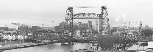
14 November 1998 - Got inside an appartment-building on the Noordereiland, at the Prins Hendrikkade. I saw no chance to infiltrate, so as a last effort I simply asked two ladies who were coming home: "Could I make some photographs of the view?" And they let me in.
Looking South - The "Hef" railway bridge (400m distant). In the background the smoke plumes from the AVR, the communal garbage incinerator at the Doklaan (3km distant). Notice the old houses at the left. They stood along the railway in earlier times and from the train you could look into their back gardens and bedroom windows. They're in terrible shape now, but the south part of Rotterdam ("the wrong side of the river") once was full of them.
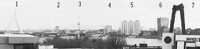
Looking Southwest - 1 = Erasmus Bridge, 2 = Van Ommeren
building at the Westerlaan, 3 = Euromast, 4 = Maastorenflat, 5 =
Boompjesflats, 6 = Building "De Maas", 7 = Wilemsbrug.
In the lower right corner you can see a part of the appartment
building. The next picture was taken from there and it looks
South-West:
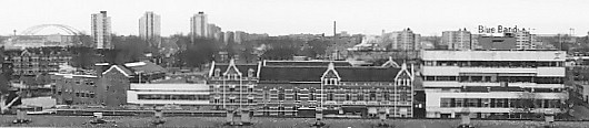
On the left the Van Brienoordbrug. In the foreground the Blue Band / Calve factory (margarine / peanut butter) that's part of the Unilever organization.
The old buildings date from 1891 and were founded by Simon van den Berg who first produced butter. One of his competitors and arch enemies was Jan Jurgens and they fought a bitter battle sometimes using industrial espionage against each other. But in 1927 they merged forming the Margarine-Unie. In 1929 they again merged with the Lever Brothers from Brittain, forming the Unilever multinational company.
Go to: Home
© 1999 Petr Kazil - 14 February 1999