To next page
Al Khwarizmi (847) Surat al Ard (about the Face of the Earth) from Uzbekistan, lived in Baghdad.
--------------------------------
von Mzik, Hans :
Africa nach der Arabischen...(1916)
Mostly taken from; von Mzik; Africa nach der arabischen Bearbeitung....al Hwarizmi(1916)
Also called : Harezmi, Kharezmi, Kharazmi
He mostly translated Ptolomy. He ads some new things.
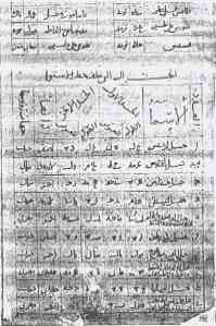
The names of the cities;
The names of the towns which are behind the equator.
Rafata at the sea; 65 deg longitude -8 deg latitude
Kanana at the sea, 72 deg 30' longitude 2 deg 45' latitude
(On other copies this is called Fanana; it is his translation of Ptolemy's panoun Komei (Pano village)
Madinat at-tib, 72 deg longitude 4 deg 30' latitude (lit: town of good smells)
(this is his translation of Ptolemy's Aromata emporium, south of which came Zygisa acra (Zingium))
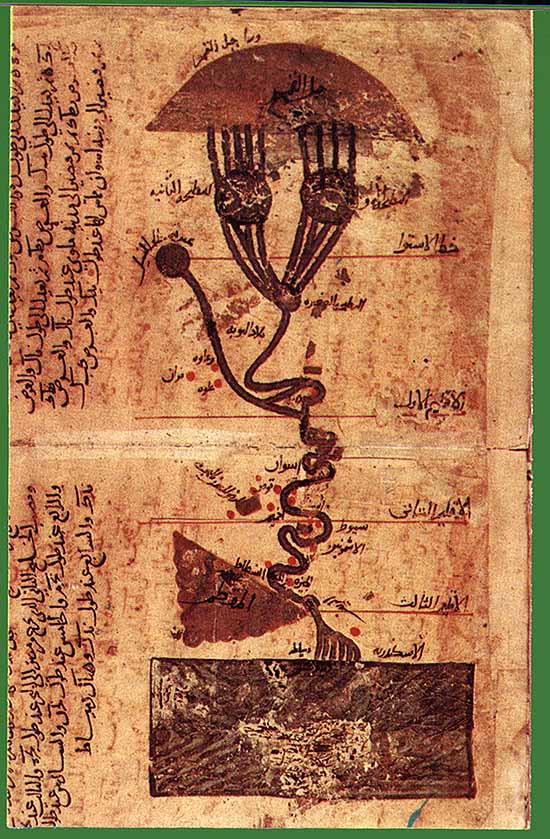
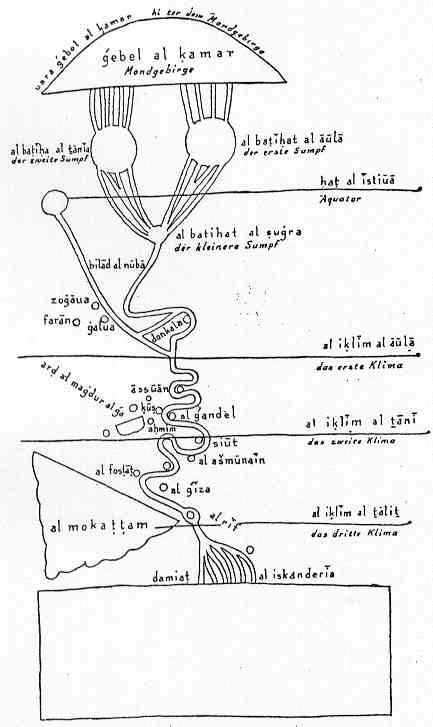
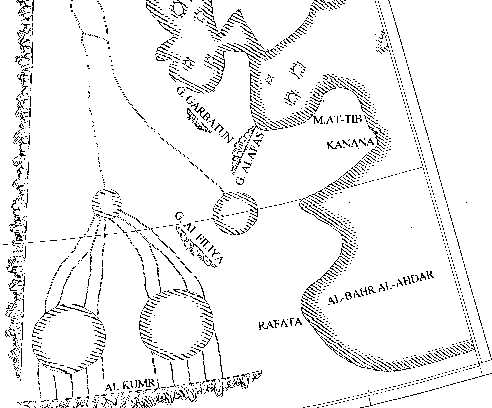
The mountains of al-Kumr, out of which the Nil of Egypt springs. (starting from) 46 deg 30' longitude -11 deg 30' latitude (up to) 61 deg 50' longitude -11 deg 30' latitude
(He is the first to talk about Djabal al-Kumr (the mountain of Kumr))
The mountains al-Filiya at 58 deg longitude 0 deg latitude (up to) 60 deg 10' longitude -3 deg 25' latitude
The mountains of Alafas at 62 deg 20' longitude 2 deg 35' latitude (up to) 64 deg 25' longitude 5 deg 25' latitude
The starting point of the Dark sea. The coastline continues to longitude 64 deg 30' and latitude 5 deg 20' then to longitude 65 deg 20' and latitude 5 deg, to longitude 68 deg and latitude 5 deg and passing at the base of a city - by longitude 69 deg 30' and latitude 6 deg 10'. - Then it continues in the form of a crossbow passing by the city of Madinat at Tib, touching the base of the city of Kanana at longitude 72 deg 30' and latitude 2 deg 20' to longitude 66 deg 20' and latitude 0 deg 20' , from here to longitude 68 deg 40' and latitude -3 deg 30'. Reaching the city of Rafata at longitude 65 deg 0' and latitude -7 deg 30' and then to longitude 68 deg and latitude - 13 deg. The latitudes that we find here are always the same. Now goes the coastline to longitude 72 deg and latitude 14 deg and up to longitude 112 deg and latitude 14 deg.
The names of the springs situated beyond the equator;
River, springs out of the mountains of Aliha at longitude 30 deg 30' and latitude -5 deg. He flows to longitude 27 deg and latitude - 3 deg 30 ' and then ends in the sea in the first clime at longitude 19 deg and latitude 6 deg 10'.
Two round seas, the diameter of each is 5 deg. The center of the first is at longitude 50 deg and latitude -7 deg, the center of the second at longitude 57 deg and latitude -7 deg. Into the first run 5 rivers from the mountains of al-Kumr. The start of the first river is at longitude 48 deg and the second one at longitude 49 deg, the third at longitude 50 deg, the forth at longitude 51 deg and the fifth at longitude 52 deg. Just the same we have 5 rivers coming out of al-Kumr into the second lake. The first river starts at longitude 55 deg 20' , the second longitude 56 deg 20' the third longitude 57 deg 30' the forth longitude 58 deg 20' and the fifth longitude 59 deg 10' . Out of each of those two lakes run four rivers towards a third round lake, which is situated in the first clime. The diameter of this third lake is 2 deg. and its center is at longitude 53 deg 30' and latitude 2 deg. The start of the first river, which comes out of the first sea is at longitude 48 deg 40' the second one at 49 deg 30' and the third at longitude 51 deg 15' . The second and third stream are united longitude 42 deg and latitude - 1 deg, from here they continue as a sole river. The start of the first river is at longitude 52 deg . The first river which out of the second lake also in the small third one flows, starts at longitude 55 deg 30', the second at longitude 56 deg 20' and the third at longitude 58 deg. The second and the third come together at longitude 56 deg. and latitude -1deg 40' and run after this in the named sea as a united stream. The forth river starts at longitude 59 deg. Each of these rivers runs into the third small lake, without that their mouth is close to the mouth of any of the other rivers. Out of this last lake comes a single very big stream, and that is the Nil of Egypt and he goes only through the Sudan and Alwa and Zagawa and Fazzan and Nubien and runs past Dongola, the capital of Nubia at longitude 52 deg 20' and latitude 2 deg of the first clime....
He also mentions the island of the anthropophagous Zanj, 4 degrees in length and breath, with its center at 138 deg. longitude and 3 deg, latitude south of the equator.(east of Taprobane) (which because it is so far from the African continent, might also be Zabay)