To next page
Al Idrisi (1150) (Kitab Ruyar) written in Sicily
-----------------------------
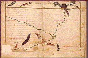
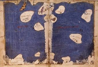
To the left: The sources of the Nile according to Idris (map from the Paris manuscript)
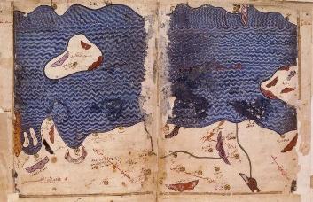
The island left is Socotra; the island right is Kanbalu. Among the cities on the African coast in this section are from the left: medinat Bazua; Karmua; Merca.
The multitude of islands are the islands of the Zang. Some of the towns in this section on the east African coast (on top) are: Baduna; Malinda; Monfasa; al Banis; Bathana.
M. Guillain: Documents sur l'histoire, la geographie
Neville Chittick: East Africa and the Orient.
The original translation by Jaubert
(Kitab Ruyar means book of Roger) (This is Al-Idrisi's geography book named after his employer Roger II of Sicily)
Al-Idrisi did not travel to the lands he described, he collected all information from hear say.
Al-Idrisi on his world map divides the east African coast in first Berbera and then the Sofala Coast. The coast opposite Zanzibar he calls Zanj.(on his map)
Idrisi talks about the interior of East Africa. His description is basically a geographical one (the Nile) and about the animals (mostly fish in the Nile)
Forth section (of the first climate)
This section exists of the description of Nubie, part of Abyssinie, the rest of the tropical part of the land of the Tadjowin, and of some of the oasis of the interior.
The best known residences and the best known towns are in Nubie, Coucha, Alwa, Dongola, Bilae, Soula. In Abyssinie, Marcata and An-Nadjagha. Among the oasis of the interior in part of upper Egypt, Syene (Oswan), Atfou and Ar-Rodainl.
It is in this section that is the place where the Nile splits into two branches, that is to say:
1: The Nile of Egypt who runs through the country from south to north, most of the towns
of Egypt are built on the sides and on the islands of the river.
2: The branch that runs from the east, and runs to the far west, it is on that branch of the
Nile that you find most of the towns of the Sudan.
The source of those two branches of the Nile is in the mountains of the moon, which starts at 16 degrees from the equinox. The Nile originates in this mountain out of ten fountains, of which five gather in a great lake. The others also come down from the mountain towards another great lake. From each of these two lakes leave three rivers who wind up uniting and run into a very big lake, close to that lake is a town called Terma, densely populated and in a fertile rice growing area. At the lake side is a statue of a man that has the hands lifted towards his breast, people say it was a bad men who was transformed this way.
One finds in the lake a fish of which the head, has a mouth that resembles that of a bird. There are also other remarkable animals. That lake is situated behind, but very close to the equinox line. On the interior looking part of the lake it receives the water of six rivers. A mountain in the lake separates it nearly into two. The mountain spreads out towards the north west. On the side of that mountain, a branch of the Nile, which runs to the west leaves the lake, and that one is the Nile of the blacks, on the side of it are situated most of the towns of that land. Another arm leaves the lake on the east side of the mountain. This one runs north through Nubia and Egypt and splits in lower Egypt in four branches of which three go into the Mediterranean and the forth in a salt lake that stops close by, meaning at six miles from Alexandria. This last lake is not connected to the sea, but is made by the inundation of the Nile. It stretches over a short extent parallel to the river and we will talk about it then, if God whishes.
Starting from the mountain of the moon, you count, going north after passing the ten rivers and their lakes, to the great lake, 10 days on foot. The size of those two small lakes from east to west, is six days on foot. In that land (10 days wide) that we just described there are three mountains, directed east-west. The first which is closest to the mountain of the moon, was called by the priests of Egypt the mountain of the temple of the images. The second which follows the first towards the north received the name golden mountain because of the gold mines there. The third, next to the second is named together with the land in which it stands, the land of the snakes. The people of the place say that you see there big snakes that kill just because they exist. There are also scorpions, very big, black colored, and instantly deadly when they bide. This is reported by the author of "the book of marvels". Codana, the author of "kitab 'l-khizana" says that the Nile from the source till the delta at the Mediterranean is 5634 miles.
(Note: when describing Egypt, he states: The length of the river from its sources to the mouth, if you have to believe several authors, 5434 miles. The author of the Kitabo 'l-Khizana however says it is 4595 miles long.)
The length of the river in Nubie is thousand miles after which writes the author of "the book of marvels" the length in the area of Micr is one third of a thousand miles. In the small lakes, and beyond in the Nile one finds crocodiles. One also finds water-animals called pig which are bigger then the buffalo, who stay close to the Nile, feed of the vegetation that grows there, and go back into the water. One also finds in the Nile fish:
1: a round fish with a red tail called lach, good to eat but hard to find.
2: The abramis: a white fish, round and with a red tail, one says he is the king of the
fishes very good to eat fresh or dried and salted, but is small, as long as the palm of
your hand and one third of that wide.
3: The rai: (salmon) big red fish. There are big and small ones. The big ones are up to
three pound. Good to eat, something like abramis.
4: The bonne (carpe) big fish, great in taste, you find them from about 5 to 10 pounds.
5: The balati, round fish like the afar which one finds in lake Tiberias. There are few
bones in and its tasty, sometimes you find them of 5 pounds.
6: The loutis (latus) the fish one calls farkh (perca) in Egypt, good to eat, very oily, you
can find them, but rarely as heavy as a quintal.
7: The lobais, good to eat, fine taste and does not have , till boiled, the odor of fish. One
uses the fish in the kitchen for many things even as meat. Its meat is solid. There are
big and small ones, even up to ten pounds. All these fish have scales. You can find (in
the Nile) others who don't. Among those are:
8: The samous , a fish with a big head very fat and sometimes about as heavy as a quintal.
One sells him cut in pieces.
9: The ninarial, a long fish, with a mouth like a bird.
10: Om Obaid, fish without scales that has monthly bleedings.
11: The djalbira, fish without scales, a fish of about one pound, poisonous.
12: The chal, a fish who carries on his back a thorn with deadly poison.
13: The ancalis (anguille) fish resembling a snake, and quite poisonous.
14: The djirri, fish with the back black and with a moustache a big head and a small tail.
15: The cafou, round fish wit rough skin used by the women to card flax.
16: The rada: a fish round as a bole, somehow rough, somehow poisonous so that if you
touch it your hand feels sudden pain and you are forced to let go. The fish keeps this
quality as long as it is alive, but when dead, becomes like all other fish.
17: The water dogs. (kilabo'l-ma) who resemble dogs and have different colors.
18: The water horse (faraso'l-ma) who resembles the horse in its appearance but it is
small and has feet as a duck. It contracts them when wanting to lift and opens them
when letting them down. It has a long tail.
19: The sacancour, a kind of crocodile. It is different from the fish in so far as that it has
hands and feet. It is different from the crocodile as it has a sharply pointed tail, where
as the crocodiles is round. Its grease is counted as an aphrodiastic medicine as well
as the salt used to preserve it. The sacancour is nowhere found but in the Nile up
to Syene.
20: The crocodile (timsali) who also does not exist in any other river or sea then the Nile
of Egypt. It has a long head specially shaped so that it is equal to the other half of the
body, the tail is scaled. It has such strong teeth that if it gets a dangerous animal or a
man it is sure it will pull it into the river. It is amphibious, because often it spends a
day and a night on the shore walking on its hands and feet. It is dangerous at land, but
less then in the water where it is really at home. However, the all powerful has made
him an enemy in a little animal between the beasts of the Nile which is called lachk
(ichneumon) which always observes him and the moment he opens the mouth it goes
inside into the intestines and eats his liver and intestines, making him die.. .. ..
Fifth section(of first climate)
Is about Ethiopia
Note: this passage which has at first sight not much to say about east africa can be used as an argument in the discussion on where the Wadebuli come from. The Wadebuli are known from oral traditions to have lived at certain Swahili cities at the coast, now all in ruins, and it is suggested that they came from the city of Daybul in India. These cities were off course not really filled with Indian people because they are real Swahili ruins, but the places might have had special commercial relations with the town, which made merchants from there or their descendants to settle in the place.
When describing the beauty of the women in Nubie, Idrisi gives a list of the best known races in Africa:. .. comparable with the ones of Nubie in all the countries of the black, not in Magzara, not in the country of Ghana, not among the citizens of Canem, not with the Bodja, not with the Abyssins , either with the Zindjes....
Haoudi, bird of Sofala, who nicely repeats what he hears, and talks even better then the parrot ( Babbagha).
The special ivory taken from the rhinoceros, (Kerkedan) is as much looked for as that of the elephant. Among other precious objects, they make of it for the kings of India handles for table knives, which become wet when you bring to the kings dishes into which is mingled some poison, that way one can immediately figure out if the food is poisoned. Cut in its length the horn of the rhinoceros offers to the eye remarkable designs, one can see in there figures of people, birds, and other things, nicely pictured, and from one side to the other. One can make of them belts of very high price.
This section is the description of, in the south, the towns of Carfouna, Markah, and el-Nedja .
(On his maps it consists of the regions of barbar below the Habasha as well as Ard Kafarat as Sudan) (Black Pagan Land)
These three countries are the southern end of the dependencies of Berbera, and are situated at the shore of the Yemen sea. The people of Berbera feed themselves for a big part on sea turtles who they call: lebeh.
One can reach Carfouna from Djonah by sea in two days. The land is dominated by a big mountain that stretches south. From Carfouna to Termeh , three days by sea. It is there that starts the mountain of Khakoui, (Ras Hafun) who has seven peaks, really high, and the mountain continues under the water for 44 miles. Close to those peaks are the villages known as d'El Hadye (Somali). From Khakoui to Markah you have by sea three small days and seven over land. Two days from Markah in the dessert is a river that floods just like the Nile and on which one sows dourha. From Markah to El-Nedja, a day and a half by sea and four by land.
El-Nedja is the last dependency of Berbera. From El-Nedja to Carfouna takes eight days. El Nedja is a small town at the sea shore. From there to Bedouna is six days on foot. It is a sizable village, lots of people. The natives eat frogs, snakes and other animals for which people mostly feel horror. This country borders to that of the Zendj. Carfouna and Bedouna (is Barawa) are pagan, their territory touches that of the Zendj along the coast. This hole area has opposite it to the north Yemen, from which it is separated by a sea arm of about 600 miles wide but depending on the depth of the gulfs into the interior and the penetration of the capes into the sea.
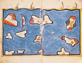
In this section are also four islands two of whom on the East Side in the gulf of the Weeds and called Khartan and Merian. (the twin islands of Khuriyan and Muriyan or Kuria Muria) The third is Socotra, (On his map Idris gives the following coordinates for Soqotra latitute11 deg, longitude 72 deg.) known through the aloes that it produces, and at two days by boat with good wind. Opposite this island on the coast of Yemen is the town of Berbat (Merbat). The fourth island is called Cabala (Quanbala he places it close to Socotra. There is a Quanbala on the mainland in N-Somalia, it still exists).
It is found to the west of that deserted section (juz) It is uninhabited but thickly wooded, with rugged mountain chains, various species of wild and dangerous animals, as well as a waterfall which falls into the sea. Sometimes boats carried away (akhrama) from Yemen or vessels from Qulzum (or Colzqoum) or Abyssinia put into this island seeking refuge. It is opposite the strong point called Mikhlaf Hakam on the coast of Yemen.. .. ..
About the island of Socotra, it is big, well known and covered with trees. It's best known vegetable product is the tree that produces aloes, and nowhere exists, nor in the Hadramout nor in the Yemen, nor in the Sahar, and nowhere else, aloes that comes in beauty close to that of Socotra. This island is as we have said from the north and west side close to the province of Yemen from which it is a dependency and a resemblance Confronting it on the Bilad az Zanj side are towns of Malindi and Mombasa. Most of the people on the island of Socotra are Christians.. .. ..
Idrisi also talks about the island of the monkeys, at two small madjrds (day trips) from the continent close to Abyssinia, and two madjras from Socotra.
The town of Aden is small, but very well known because of its harbor from where the boots leave for Sind, India, and China. One brings from these countries the following: iron, damascene swords, skins, musk, aloes wood, saddles, pepper, coconuts, perfumes.. .. ebon wood, tortoise shell, camphor, muscade,.. .. elephant tusks,.. .. and also most of the aloes for trade.
This section consists of the description of a part of the Indian sea and all the Islands that are in it, in which people of different races live. In the south of the countries in this section is the rest of the countries of the black kaffirs, and several countries close to the sea. Our intention is to describe all those things with clarity. So we say that that sea is the Indian Sea and on its shore is situated the town of Bedouna, at the extremity of the country of the kaffirs, unbelievers who have no revealed religion, but take standing stones (al-ahjar al-qaina) which they anoint with fish oil and to which they prostrate themselves in worship. That high is the stupidity in which these people live and the absurdity of their believes. Part of this country obeys the Berber king the rest the Ethiopian one.
From Bedouna, on the coast to Medounat is three days. This last town is in ruins, nearly deserted, dirty and difficult to live in. The peoples live from fish, shells, frogs, snakes, rats, lizards, and other horrible reptiles. These people practice fishing without boats, but they do not keep to the beach either. They swim with little home made nets of vegetable fibers attached to their feed. Through lines with nods that they keep in their hands they close the nets as soon as they feel that the fish got in it and that with an art in which they excel and with tricks in which they have a long experience. To attract the fish, they use common reptiles. Although they live in problems and big poverty, these people, God likes those who live a homely live, are satisfied with their lives and what they have. They obey the Zendj government.
From Medounat (Maqdishu?)to Mulanda (M.l.n.da)(Malindi)(350 miles), one follows the coast for 3 nights and 3 days (by boat). Mulanda, a town of the Zenj is situated on the edge of the sea at the mouth of a river of sweet water. ( Today Malindi is 4 miles south of the Sabaki river, some authors name Gedi as the original Malindi). It is a large town in which the inhabitants engage in hunting and fishing. On the land they hunt tigers and other ferocious animals. They obtain various kinds of fish from the sea, which they cure and sell. They possess and exploit iron mines, this is for them an object of commerce and the source of their greatest profits. In the town there are maqanqa (or El-Mocnefa) (sorcerers). They pretend to know the art of enchanting the most venomous snakes to the point of making them harmless for everyone except those they which to harm. They also pretend they can enchant lions and tigers so that they can not harm them.
It is a two days journey along the coast (by boat) to Manfisa. This is a small place and a dependency of the Zenj. The inhabitants of this place work in iron mines and hunt tigers, ( the name of this town is a mix up of Mombassa and Mafia in one and the same location). They have red colored dogs that fight every kind of wild beast and even lions. Mafisa is on the sea shore opposite the mouth of a great river up which it is possible to sail for two days. (like Mafia opposite the Rufiji). (the part between Mombassa and Mafia is non existing in the book of Idrisi) Its banks are uninhabited because of the wild beasts that live in the forests were the Zanj go to hunt, as we have already said.
The king of Zanjibar lives in Mafisa. His guards go on food because they have no mounts: horses can not live here.
From Manisa to the village of El'Banas on foot, six days, and by sea one and a half days. El-Banas is a very big and heavily populated place. A one-sided drum called Er-rahim (Er-radjim) and big as (unreadable) is worshipped in El-banas. The drum is covered with leather on one side, on which a cord is attached to beat the drum. It makes a terrible sound that can be heard 3 miles away.
Banas is the last Zenj dependency (which) borders on Sofala, the gold country. From El-Banas, on the coast to the town called Tohnet (Al-Tuhnat) by sea, one and a half days, and overland eight days, because in between there is a great golf who stretches to the south and so forces the travelers to go around, and also a high mountain called Adjoud from which the sides have been eroded by the water which hits it with great noise. This mountain attracts to it all boats that come close and sailors keep far from it.
The town of Tohnet is part of the country of Sofala and touches the country of the Zendj. There are many villages, all of them on the boards of the rivers. In the whole of Zendj country the main products are iron and the hides of tigers from Zanzibar. The color of those hides is close to red, and they are very soft. Since they have no pack animals, they themselves transport their loads. They carry their goods on their heads to two towns, Mombassa and Malindi. There they sell and buy. The Zanj have no ships in which they can voyage, but boats land in their country from Oman, as do others that are going to Zabaj (or Djawaga) (Endonezya). These foreigners sell their goods there, and buy the produce of the country. The inhabitants of Zabaj (or Djawaga) call at Zanj in both large and small ships (zawariq wa marakib kubar) and trade their merchandise with them, as they understand each other's language. The Zendj have at the bottom of their hearts a great respect for the Arabs. For this reason, when they see an Arab, whether a traveler or merchants they prostrate themselves before him. They say in their language: Welcome son of Yemen. The visitors to this country steal their children, enticing them away by means of giving them fruit. They carry the children from place to place and finally take possession of them and carry them off to their own country. Because the people of Zangibar or numerous and are short on food. The ruler from the island of Qais (or Keish) in the sea of Oman (opposite Muscat, the port that became important after the decline of Siraf) had 505 ships with which he used to raid the Zanj coast for slaves and he makes many captives.
Opposite the Zanj coast are the Zabaj (or Djawaga) islands; they are numerous and vast; their inhabitants are very dark in color, and everything that is cultivated there, dorrha, sorghum, sugar-cane and camphor trees, is black in color. Among the number of the islands is Sribuza (Jazirat Sharbua min az zanj) which is said to be 1,200 miles round; and pearl fisheries and various kind of aromatic plants and perfumes are to be found there, which attract the merchants.
(on the map the island is situated right off mount Naked (Jabal Ajrad) between al Banas and Tohnet)
(On his map two islands have the inscription : an island belonging to the Zanj.)
Among the islands of Zabaj (or Djawaga) included in the present section is Andjuba (Anjouan-Johanna), whose principal town is called Unguja (El Anfoudja) in the Zanj language, and whose people, although mixed, are actually mostly Muslims. The distance from it to Banas on the Zanj coast is one majra . The island is 400 miles round; bananas are the chief food. There are five kinds, as follows: the bananas called kundi; fili whose weight is sometimes twelve ounces; omani, muriani, sukari. It is a healthy, sweet and pleasant food. The island is traversed by a mountain called Wabra. The vagabonds who are expelled from the town flee there, and form a brave and numerous company which frequently infests the surrounding of the town, and who live at the top of the mountain in a state of defense against the ruler of the island. They are courageous, and feared for their arms and their number.
The island is very populous; there are many villages and cattle. Another translation reads; the island has many buildings linked together. They grow rice. There is a great trade in it, and each year various products and goods are brought for exchange and consumption. In the past when India was in confusion, the Chinese, transferred their trade to the islands of Zanedj or Zaledj, and the islands that depend from it, facing the coast of the Zinj, where they came to intimate relations (ishra) with the inhabitants on account of their mildness and accommodating ways. It is because of that that this island is so populated and receives so many visitors.(Some authors think these islands are Zanzibar, Pemba.. .., but most probably the Maldives or Laccadives )
Close to that island there is another one, not so big, Jazirat min az Zanj, with Jabal an-Nar dominated by a big mountain, of which the sides and top are inaccessible, because everybody getting close is burned. (this island is without doubt La Grande Comore) During the day there is a dense fog, and during the night a heavy fire. From its base springs water, some cold and sweet the others hot and salt.
Close to the above island of Zanedj ( Jazirat min az Zanj )one finds another, with the town of Kahua (Kua on Juani Island) on which the people are black. They are called Nerhin. They wear the dress called Azar and the
Fouta. They are fierce people, brave, and always walking armed. Sometimes they get into their boats and attack merchant ships, of which they take all merchandise. Only their own countrymen they leave to go home, they do not fear any enemies. It is separated from Sahil az Zanj by a majra of a day and a night. Between it and the island of Ranih (also Unfuja) (or El-Anfrandji) is a majra of a day....
Amber is a substance that comes out of springs deep in the sea, like naphtha that comes from sources in the Hit.
(At the south end of Pemba began the Sofala country) (Art Sufala) (Sufala is used to mean shoal water, sometimes however it means lowland)
This section embraces the description of the remainder of the country of Sofala.
You first find two towns or better two big villages, in-between there are villages and camps that resemble those of the Arabs. Those big villages are called Djantama and Dandama (Chindi and Quilimane?) They are situated at the sea shore and rather small. The inhabitants are poor, miserable, and without resources to support them except iron, of this metal there are numerous mines in the mountains of Sofala. People of the Zabag (or Zanedj or Raneh) come hither for iron, which they carry to the continent and islands of India where they sell it for good money, because it is an object of big trade and it has a huge market in India. For although there is good quality iron in the islands and in the mines of that country, it does not equal the iron of Sofala for its quality and its malleability. The Indians are masters in the arts of working it. They prepare and mix the substances so that through fusion one gets the soft steel normally called: India steel. They have factories that make the best swords in the world. This is how in iron Sind, Serenbid and Yemen rival among each other in quality through local circumstances, as well as the art of manufacturing, the pouring of the steel, the smelting, and the beauty of the polished surface. But nothing cuts better then this iron from India. Everybody knows that and nobody can deny it.
From Djantama to Dandama is two days by sea and seven by land. Dandama is one of the important towns of Sofala. Three more are close to its territory. One of them is Sayuna. Sayuna, (a settlement at the mouth of the Zambezi?) is medium in size and its inhabitants are a collection of people of Hind, Zunuj (Zanj) and others. The town is situated on an estuary (khor) (another translation reads: gulf) into which the ships of the voyagers can enter. (One of the Manuscripts has added here:) (It is here that the ruler lives, he has soldiers, but there are no horses in the country.) From it to the town of Bukha along the coast (al as sahil) is three majras. Also from Sayuna to Dandama, of Sofala towards the west, by sea, three days, and by land about 20 days (marhala) . Because in between there is a large gulf, extending south, which forces to go around it. From Bukha to Djantama ( this is a mistake it should read Jabasta) by sea one day, four days overland. In the whole country of Sofala one can find gold, in abundance and from excellent quality. But the people like more copper, and they make jewelry from that metal. The gold one finds in Sofale is more, in quality and volume, then that from other countries, because one can find pieces of about one or two mitqals sometimes even of a rotl. They melt it in the desert, in a fire of cattle dung, and it is not necessary to use mercury for this, like it is done in west Africa because the people of this last country united their pieces of gold and mix it with mercury.....
The gold of Sofale does not need that process, but it is melted without chemicals.
Tortoise shell is the most important product of some islands close to the island of El-Qomr. One can split it in seven portions, the heaviest being half a mann. It is big, transparent and very varied in colors.
We have said that in the south of this sea is a part of Sofala, of which we have already talked, and that among the habited places is the town of Jabasta, not so big. There is quiet some gold, its exploitation is the only industry and the only income for its people. They eat sea turtles and shells, there is not much dhorra among them. The town is situated in a big gulf where the boats can enter. The people of Jabasta who do not have boats or beasts of burden to carry their loads, are forced to carry their loads themselves, and to help out each other in this. Also people from Qumr (Madagascar) and merchants of the land of the Mihraj (ruler of Sumatran empire of Sri Vijaya) are well received ( in Jabasta of Sofala) and carry on trade there. From the town of Jabasta to the town of Daghuta by sea is a journey of three days and nights, and from it (Jabasta) to the island of Qumr is one majra.
The last town on the coast of Sofale (Sufalat at tibr) is Daghuta (Angoche in Mozambique?) and its territory, and there most gold is found. It is in a big gulf, the people are naked. They cover with their hand their sexual parts when merchants come to them from neighboring islands. The women are afraid and never show themselves in the markets nor in the places of business, because of their nakedness. That is why they are confined to their homes. One finds more gold in these territories then anywhere in Sofala. This land touches on that of the Quac-Quac, where there are two miserable, dirty towns. This is because of the scarceness of food and scarceness of all other things to. One is called Derou (or Zaoura, this last name comes close to the river Zavora, in that neighborhood) and the other Nebhena or Iana'ana (what comes close to modern Inhambane). In its neighborhood is a big village called Dargha or Daghdagha, the natives are black, with hideous figures, a deformed complexion: their language is a kind of whistling. They are absolutely naked, and little visited by foreigners. They live of fish, shells, and turtles.
They are (as we have said) neighbors of the island of Wacwac, of which we shall speak later, God willing. All of these countries and islands are situated in a large gulf. Neither gold, nor ships, nor commerce, nor beasts of burden are found there. As for the island of Djalous, its inhabitants are Zendjes; they live, as we have said, from anything that falls into their hands. In the island is a mountain, whose soil is mixed with silver. If one approaches this soil with fire, it dissolves and becomes silver�..
At other places in his work we still have the following:
Malai is a great island in the eastern seas, it stretches eastward nearly from the coast of Zanj.
Note: Idrisi uses both words Zanj or Zanzibar (on his world map), which is a word of arab origin and Unguja (in his text) which is a Swahili word to talk about the main town.
At some complete other place in his work Edrisi talks about the Indian town of Daybul close to present day Karatchi.
...The place is inhabited only because it is a station for the vessels of Sind and other countries ... ships laden with productions of Uman, and the vessels of China and India come to Debal.
There exists in the centre of the Persian Gulf opposite Muscat an island called Keich, square in form 12 miles long, of which a certain governor of Yemen took possession. He fortified it, he populated it and equips it with a fleet, and with that he takes control of the coasts of Yemen. That man makes travelers and merchants lose lots of money, steels everything of everybody, and he damages the trade so that it turns from Oman to Aden. With his fleet he destroys the coasts of Zendj, and the ones of Gamran. The people of India are afraid of him and resist him with ships called el-mechiat, about which we have already spoken�.. This man up to today continues his predatory expeditions, he is very rich, and nobody can stop him.
The name of Belhara means king of kings and is inherited here, just like in other parts of India, where when a king ascends the throne, he takes the name of his predecessor and transfers him to his heir. This is an established costume which the people never change. It is also like this among the Nubie, the Zendj, the Ghana and the Persians and in the Roman empire�..
The people that live in the first climate are swarthy, others black. In the first case you have the people of India, Sind, China and the coasts. As to those who live in the deserts of Zenghebar, Abyssinie, Nubie, Soudan, and of whom we have already spoken, those because of the lack of the moisture of the sea, and because of the intensity of the heat of the sunlight to which they are constantly exposed; those we say have all kinky hair, black skin, stinking sweat, the skinon the legs that is dried out, a deformed body, little industry and small intelligence. They live in extreme ignorance and it is under that title that they are known. There are among them no scholars, and all what their kings know about justice and government, they learnt it from people coming from the third and fourth climate, who had read the history of the ancient kings. Among the animals found here in the first climate and not in the six others are the elephant, rhinoceros, the giraffe, monkey with tail��.