To next page
Ibn-Hawqal (970) from Baghdad. (Kitab Surat al-Ardh) (the shape of the earth). also known as:
(al-Masalik wa'l-Mamalik)
--------------------------------
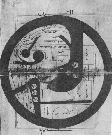
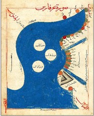
The picture left is a map of the Indian Ocean. It is not found in the original manuscript of ibn Hawqal but in Persian translations of it. (map found in the Miller atlas)
Taken from the French translation ; Configuration de la Terre.
Also extracts from: - Marcel Devic; Le pays des Zendjs
One of his travels brought him 20 degrees south of the equator (Sofala) along the African coast. One of the things he noted was that there were large numbers of people living in areas that the Greek said were uninhabitable.
I don't mention the countries of the blacks in the Maghreb, nor the Buja, nor the Zendjs, not the other groups living in their neighborhood, because the good organization of the empires comes with religious convictions, good morals, and wise institutions, and the conservation of wealth depends on a just method of government. Or those ones neglect those qualities or they do not participate in them and so need a different place from the viewpoint of the development of the other empires.
As to the largeness of the land-area, from the extreme north to the southern limit, it starts beginning from the coast of the Ocean to come to the territory of Gog and Magog, passing through the territory of the Slaves, passing the region of the interior slaves Bulgares, and the Slaves, further on the country of the Byzantins, the land of Egypt, and Nubia, stretches through the deserts between the lands of the Blacks and the Zendjs, to finish up at the Ocean....
There are Gulfs in the region of the Zendjs, as well as in the neighborhood of the lands of the Byzantins, where one also has seas, but we will not mention them because they are small in comparison with the other seas, and also because there are so many....
Abyssinie stretches along the Red sea, which is in reality the Persian sea, and which goes up to the land of the Zendjs. From the other side it is limited by the desert situated between Nubia and the Red sea, and an other frontier goes along the Buja and the un-passable desert. The territory of the Zendjs is the longest of all the Black countries, it borders the Abyssinians.... (All this he textually copied from Istakhri)
The Indian empire is situated opposite the land of the Zendjs, in the eastern part of the Persian Sea....
Then this sea stretches along the Abyssinian sea, arrives at the end of the land of Nubia to get to the regions of the Zendjs, which are the biggest ones in these areas. After that the sea continues among the countries of Islam.....
An extract out of a battle in upper Egypt between the forces of the emir and the tribal Buja:
Qummi also has Koran verses written on banners, put up in an imposing line and attached to the lances, and he has them proclaim in the early morning; look here for you soldiers of the Buja, the messages of the emir of the believers. The Buja were arranged for battle, seeing this, they become curious and several leave the ranks to get closer. Qummi had had put the flags on the camels who carried the drums. When the Buja where among the written banners, the Zendjis start beating the drums, the ranks of the Buja are broken and they flight in disorder. This might well be one more example of Zanj mercenaries in the Egyptian army.
At the altitude of Yemen basin, the sea is called sea of Aden, and this up to Aden, then it is called sea of Zendjs, and this opposite Oman where she goes towards the sea of Persia. It is a sea that becomes so large that crossing it to the land of the Zendjs is 700 parasangs. (1980 miles) It's an obscure and dark sea, under its surface nothing is visible. Close to Aden there is a fishing ground for pearls, who are brought to Aden.
After passing Oman, passing the limits of Islam, and continuing to Ceylon, this sea takes the name of Persian Sea. She reaches a very big surface. On the opposite shore are the lands of the Zendjs.
The land of Abyssinia ..... After that the territory continues to the land of the Zendjs, situated opposite Aden..... . Those gold mines extend (from Abyssinia) up to the land of the Zendjs along the sea..... Following certain sayings there are in the land of the Zendjs cold regions, in which white Zendjs live. I already said that this country is miserable, with few people few little cultivated lands, except for the area around the residence of the king....
The southern ocean.....passes to the south-east of Sama and Ghariwa, in a country with innumerable inhabitants, until it reaches the desert which no one has yet crossed.
Between the hinterland and the regions of the Zendjs, there are big sand wastes, who formerly were passable, that was the route from Egypt to Ghana....
Nobody knows the sources of the Nil : in fact the Nil comes out of an impassable desert, from beyond the land of the Zendjs, and penetrates the region of the Zendjs, goes through the deserted and cultivated parties of the Nubia, then waters the fields uninterrupted till its arrival in Egypt.
(the copier has here added)
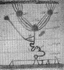
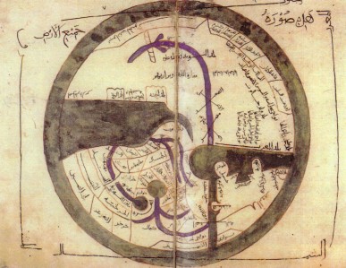
The author of the book pretends that nobody knows the sources of the Nil and that this river comes out of the deserts situated behind the lands of the Zandjs. I have seen in a geographical treatise that the sources of the Nil are situated in two circular lakes, fed by five rivers coming from the mountain Qumr. Each of those two lakes gives bird to 4 rivers who throw themselves in a circular lake in the first climate. Its diameter is divided in two parts, of which the center is at 53 deg. longitude and at 2 deg 31 min latitude of the first climate. From this last lake a river leaves, which is the Nil of Egypt made bigger by a river starting at the equator at longitude 59 deg 31'. It runs till close by Nubia.....
The sand bank crosses the sea and is found again opposite Shihr and Mahra, in the land of the Zendjs, where the sand is of the same kind as the one of Shihr.....
The biggest town after Chiraz is Siraf, it is nearly as big as Chiraz. The houses of Chiraz are made of teak-wood and another type that gets imported from the land of the Zendjs, the houses have several floors, like in Fostat.....
In a dispute with a rich ship owner and merchant the following sentence occurs:
It is rare that one of his boats goes to the regions of India, the Zendjs or China with an associate or someone with delegated powers, but he sometimes does give the benefit of a free cargo, without asking payment or compensation.
Where then is that land of the blacks, of which the length is seven years, in the sky or under the ground? Or the totality of their countries is situated in the second climate. Starting from Ghana at the Ocean, passing Kugha, Sama, Gharayu, Kazam, traversing the steppe that separates the Zendjs of the Ocean, Nubia, Abyssinie, the Zendjs, to arrive with the rest of their regions in the Indian regions, at the Sea of Persia and of India. This whole space is not more then a 250 days long walk and in those territories the wide is never more then one month of walking.
Between the land of the blacks and the (surrounding)ocean in the south is a desert where the enormous heat destroys all live. Just like the cold has destroyed all live between the Northern Ocean and the lands of Yadjoudj and Madjoudj (Gog and Magog).
All those Zendjs, the lowest of the peoples, are not Moslems and do neither know justice nor good manners.
(when discussing N-W afr.)
......ambergris is equally high in value as gold or black slaves
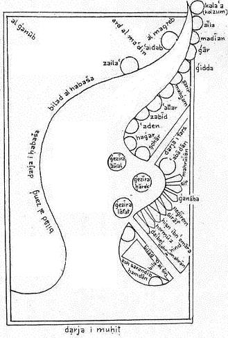
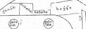
Qumbala he locates on his map opposite the dessert (mafaza) between Bilad-al-Habash (ethiopia) and Bilad al-zanj.
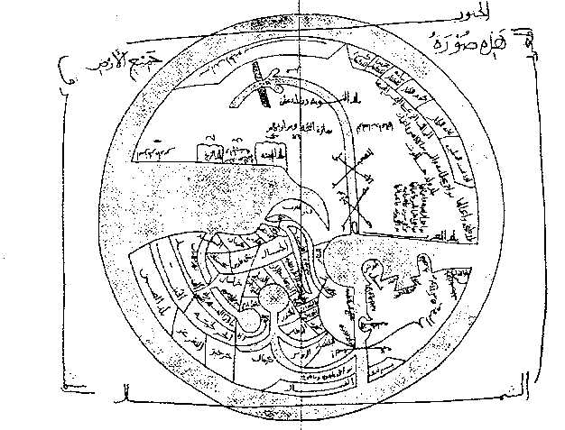
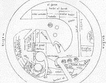
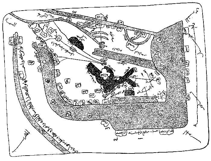
1 Origin of the Persian Sea
2 Land of the Zendjs
3 Desert that separates the Zendjs from the Abyssinie
4 The land of Abyssinie
5 Desert and waste of the Budja

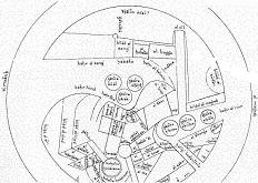
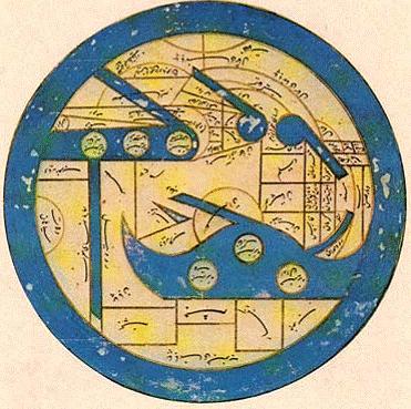
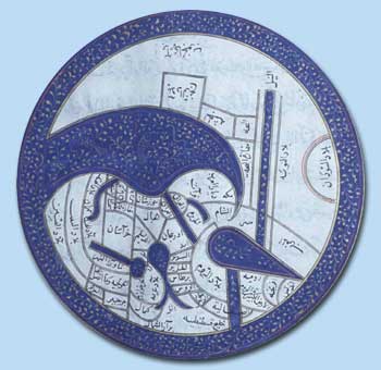
1 The region and the districts of the Zendjs,
the desert that separates the Zendjs of the Abyssine
2 the land of Abyssinie
3 Berbera
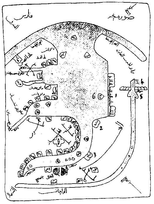
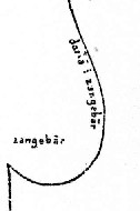
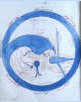
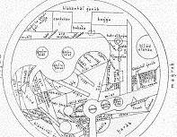
1 The land of Abyssinie
the desert that separates the Zendjs of
the Abyssine
the land of the Zendjs
2 Berbera
3 Zaila
4 Nile
5 The mountain of Qumr
6 The island of QANBALA
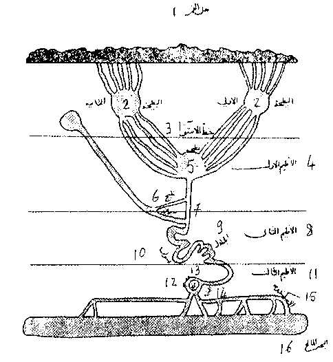
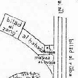
1 Mountain Qumr 9 Cataracts
2 first lake, second lake 10 Assouan
3 equator-line 11 third climate
4 first climate 12 Misr
5 lake 13 Djazira
6 arm 14 Guizeh
7 capital of Nubia 15 Alexandrie
8 second climate 16 the sea
These are not the Sources of the Nile but the Nile ending up in the Mediterranean.