 |
Coal Deposits and the "Noah's Flood Model"
|
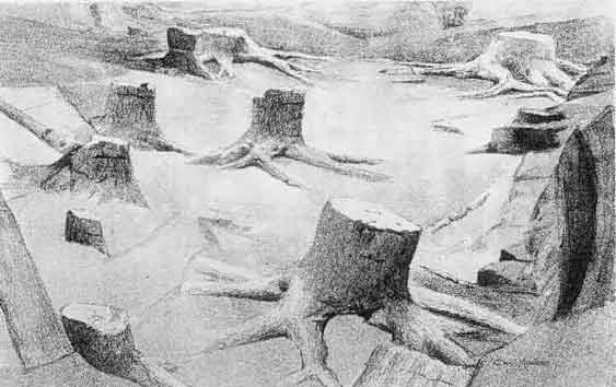
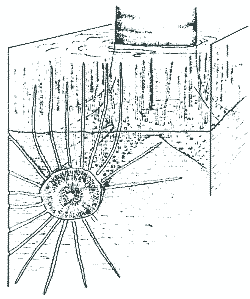
1883 sketch of upright Lycopod trees, Carboniferous 'Fossil Grove' Victoria Park, Glasgow. From Transactions of the Geological Society of Glasgow. 8, 227-235.
While virtually all geologists agree that most economic coals are autochthonous, meaning that they accumulated over time at the sites where they are found, flood geologists have argued that coal deposits in the geologic record are all allochthonous, or transported from their preflood place of accumulation and somehow buried in structural basins during Noah's flood (e.g. Austin 1986; Morris 1961; Nevins 1976; Price 1943; Scheven 1996; Snelling 1986; Walker 2001; Wieland 1996; Woodmorappe 1984). Both conventional geologists and flood geologists would agree that in situ coal deposits would falsify all the various forms of the "Noah's Flood Model" of the geologic record, all of which stipulate that the Paleozoic sedimentary record was deposited in a period of weeks.
The most widely accepted flood models for coal deposition are Scheven's "floating forest" model, and Steve Austin's Mt. St. Helens "model." Both of these models are inconsistent with the available evidence, and fail to provide a plausible account of the formation of known coals within a flood catastrophe lasting weeks or months. In fact, the abundant evidence for in situ trees, in situ cast trees, tidal rhythmites overlying some coals, and pedogenically modified soils within coal sections, constitutes another unequivocal falsification of the Noah's Flood depositional model. Most of the information in this article comes from Gastaldo (1984 and 1999), and Cobb, J.C., and Cecil, C.B., eds., Modern and Ancient Coal-Forming Environments, GSA Special Paper 286.
Evidence for Autochthonous Nature of Coal Deposits
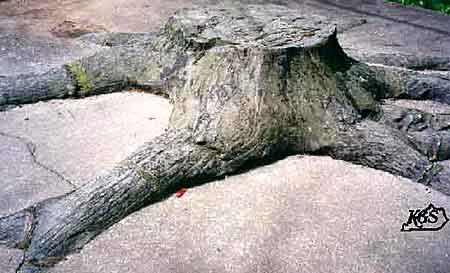
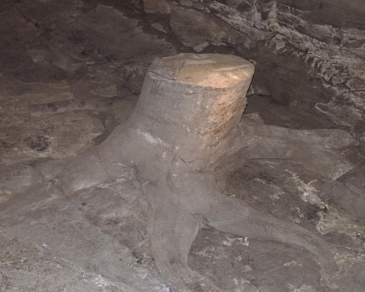
Before discussing the evidence for in situ trees in coal deposits, we should describe the stump and root anatomy of the Lycopsid trees and plants (such as Lepidodendron and Sigillaria, 7 and 5 below) found in Paleozoic coals. (Note that Mesozoic and Cenozoic coals are composed of entirely different plant faunas.)
Numerous stumps of these trees are often found in upright position above coal sea,s, and paleoecological studies of several these "standing forests" show that the distribution of trees conform to expected distribution in modern forests (several sources cited in Gastaldo, 1999, p. 149). Several locations show several standing forests, stacked atop each other, each one with roots penetrating downward into soil horizons (e.g. Dembko and Gastaldo, 1992).
[Gastaldo (1999, p. 149) also notes that for several Mesozoic and Cenozoic coals, "ample empirical evidence has been presented not only for root penetration within the weakly developed soil beneath the coal, but also for extensive, in situ, standing forests within the coals (e.g. Mossbrugger et al., 1994)."]
These lycopod trees occur alongside plants such as the sphenopsids (Calamites, for instace), pteropsids (which includes true ferns and pteridosperms, an extinct form of seed fern), and Cordaitales. Gastaldo (1984) describes the root anatomy of the lycopod trees:
The organs of the plant generally accepted as the subterranean parts of these lycopods are cruciform in shape with four dichotomizing stigmarian axes radiating from the base (Williamson, 1887). Stigmarian axes departed the base of the tree (positive geotropism) at varied angles (see: Potonie, 1920; Frankenburg and Eggert, 1969), dichotomized twice, and bore helically arranged lateral appendages sometimes referred to as stigmarian 'rootlets' (Charlton and Watson, 1982). 'Rootlets' attained a maxium diameter of 1 cm, and were deciduous at least near the base of the tree (Frankenburg and Eggert, 1969)."
Root and "Appendage" Orientation
These root systems are sometimes found extending for hundreds of feet, penetrating multiple lithologies underlying the coal seam, forming a complex, intertwined root system. In many cases, these root systems can be seen branching outward from upright trunks, and the delicate appendages extend outward from these roots into the surrounding sediments. Erect Calamites plants have also been documented in association with erect Lycopods, with roots cross-cutting the underlying lithology in the same manner as the Lycopod trees. Gastaldo (1984):
"Although erect lycopod trunks are generally found without accompanying erect vegetation, those cases in which erect vegetation has been preserved along with lycopods demonstrate the same cross-cutting relationships of stem and root structure. The only other plant convincingly documented to co-exist with lycopods is _Calmites_. Binney (1847) illustrated the positively geotropic character of calamite roots originating from successively higher nodal areas, which cross-cut bedding in the same horizon(s) in which erect lycopods are preserved. Dawson (1868), Potonie (1909), Pfefferkorn and Zodrew (1982) and others recorded the same observations, and Ward (1900) reported this condition for _Calamites_ preserved in conglomerates of St. Etienne."
Lycopod root with appendages extending laterally into sediment.
The orientation of the stigmarian axes is a crucial piece of evidence for the in situ growth of these trees, and rules out both the floating forest and the Mt St Helens/sinking log models. Gastaldo (1999) writes:
"Many authors have documented the three-dimensional nature of intertwined axes with attached appendages in a variety of lithologies, as well as the spread of these axes in a position of growth. Stevenson (1912) noted that one such forked stigmarian system in Britain extended over 826 ft2; Gastaldo (1986a), DeMichele and Demaris (1987), and DeMichele et al. (1996) demonstrated similar relationships in other Carboniferous coals. Although autochthony of these organs has been widely accepted for more than a century, Gastaldo (1984) evaluated the mechanisms that would control allocthonous emplacement of these stigmarian axes and appendages in the context of Austin's (1979, 1980) proposed floating mat model. The spatial configuration of stigmarian axes and surrounding appendages in the underclays and other clastic settings (e.g. Dembko and Gastaldo, 1992) can only be accounted for by autochthony because allocthonous emplacement within a waterlogged substrate would result in deformation of the appendages around the main axis rather than the typical helical configuration, penetrating and cross-cutting the lithology" (p. 148-149).
Gastaldo's 1984 paper elaborates on this crucial point:
" . . . the stigmarian axes interlace in a complex manner and demonstrate that the axes spread out over an immense aerial, three-dimensional surface. Williamson (1887) figured a stump with stigmarian axes which were distributed over an 926 square foot area, and recorded the discovery of a single stigmarian axis of 37 feet 4 inches in length. The stumps which are attached to such systems cross cut the encasing lithology(ies) and are commonly abruptly terminated in the upper sediments. The heights to which trunks are preserved may be minimal or may be in excess of 6 m (i.e. Teichmuller, 1955; Pontonid, 1920). The distribution of large numbers of erect trunks conform to natural spacings (DiMichele and DeMaris, 1982; Gastaldo, 1983)."
" . . .The preservation of stigmarian axial systems within the underclays of Euramerican coals can only be interpreted as in growth position and in place. As discussed previously, the cross-cutting relationships of the stigmarian axes and appendages precludes interpretation of abiotic emplacement. If stigmarian axes were abiotically introduced into the underclay by sinking, the aerenchymatous rootlets as well as the sediment itself should always demonstrate distortion."
"Examination of underclays results in the observation that there is no evidence for abiotic disruption of the sediment that would have been caused by the sinking of the axial system. Since the sediment would have been unlithified at the time of stigmarian emplacemnet, disruption of the sediments would have occurred in order to allow for complete encasement of the axial system in the undreclay. The time for sinking of the axial system with attached plant body and hypothesized peat would have been short. This rapid event would have caused compactional and deformational sedimentary structures such as flame-like structures or clay injection structures between 'rootlets' in addition to dispolacement of bedding. Underclays in association with the axial systems do not demonstrate these features. Rather, the underclays are disrupted by the growth of the rootlets through the sediment and accompanying vegetative (coalified compression) remains. In addition, the emplacement of the lycopod mat with developed peat accumulations should have generated mud diapers into the base of the coal seam. Again, the condition is not known. The coal may lie conformably or unconformably on the underclay."
"Field observations, numerous reports, and descriptions of erect lycopods support the interpretation that these plants are in situ and were not transported to their site of deposition. Stump features displayed by most preserved trees agree with those criteria proposed by Fritz and Harris (in press) to distinguish in situ from transported stumps. That the stigmarian axial systems embedded within the underclays (paleosols) of coals represent stands of lycopods in non-peat and peat accumulating environments is unquestionable. The assertion that these lycopods were abiotically, vertically emplaced from a floating habit cannot be supported by the disposition of the axial systems or the sedimentary structures accompanying them."
Additonal evidence for in situ growth of these trees can be seen by close examination of the soil layers penetrated by the root systems. Well-developed, regionally-extensive fossil soils underly many coal beds. The development of these features require that the substrate remain unburied for at least many years, which would be impossible on the any of the Noah's Flood models. Dulong and Cecil (1997) write:
Regionally extensive paleosols formed during low stands of sea level underlie most minable Pennsylvanian coal beds. Several characteristics of the paleosols indicate long-term soil formation prior to the onset of peat formation. Regional description of soil types under any given coal bed allows reconstruction of the paleowater table, the paleoclimate, the lateral variation in soil types (catena), and surficial relief.
Although clear soil horizonations are usually (but not always) absent from these soils because they were generally submerged rather than well-drained, there are numerous features identifying these layers as soils (Gardner et al. 1988; Joeckel 1995; Miller et al. 1996). Miller writes:
"Soil features preserved at both the outcrop and microscopic-scale enable paleosols to be classified using modern soil classification systems. Interestingly these paleosols show stratigraphic patterns in their development that are consistent with both sedimentologic data on cycle durations and with data on ancient climate change."
Another feature found in many soils underlying coals is spherulitic siderite (Ludvigson et al. 1998). These same features can be seen in buried soils beneath modern domed peat accumulations.
The macroscopic and microscopic pedogenic features of early Pennsylvanian soils are indicative of a perhumid climate. Dulong and Cecil:
Lower and lower Middle Pennsylvanian paleosols under coal beds in the Appalachian basin have features such as gleization, well-crystallized clay minerals, and the absence of subaerial exposure features, all of which indicate peat formation was initiated on poorly drained aquic Inceptisols. The climate was probably perhumid which is consistent with the inferred domed-peat origin of Lower and lower Middle Pennsylvanian coal beds.
Jonathon Clarke describes an early Carboniferous paleosol from South Wales, which occurs in association with thin coal seams:
"Wright (1982) reported on calcrete palaeosols from three separate horizons in the Early Carboniferous Llanelly Formation in Wales. From the bottom these are the Tyer bont pedocomplex, the Cwm dyar pedoderm, and the Llanelly pedocomplex.
"The Tyer Bont pedocomplex overlies the top of the Oolite Group. The top of the Oolite shows karsted relief of up to 1 m and clay-filled solution pipes. The complex consists of lenticular sandstones, conglomerates, and clays. The sandstones and conglomerates strongly channelised and, together with the clays, are interpreted as a fluvial channel and flood plain complex. The pedocomplex varies between 1 and 6 m in thickness. Superimposed on the terrigenous sediments are nodular, massive, blocky, and prismatic diagenetic carbonates. These form stratigraphic units and are often truncated by overlying channel units. The Cwm Dyar pedoderm is developed on top of the Cheltenham Limestone Member. This member consists of interpreted shallow marine to intertidal limestone. Palaeosols are common through the sequence and a prominent one near the top is called the Cwm Dyar pedoderm. The Llanelly pedocomplex is developed within the Gilwern Clay Member. The host sediments of this complex are an upward fining sandstone interpreted as a high sinuosity stream deposit. The palaeosols are best developed in the clay rich units.
"The clays are smectitic, variably coloured, with red and purple mottles superimposed on a background green colour. Secondary carbonates grow in this clay matrix. Clays in the upper part of the Llanelly pedocomplex are somewhat different. A grey clay-rich palaeosol with numerous rootlets and capped by a thin coal occurs at the top of the Llanelly pedocomplex. Clays in the Llanelly pedocomplex locally show pseudoanticlinal structures reminiscent of gilgai structures in modern smectitic soils.
"The nodules are found in the clays and vary in shale and size. Some have gradational contacts with the surrounding sediment, others sharp. Those with sharp contacts often appear to have shrunk relative to the surrounding sediment. In size, shape, and texture these nodules closely resemble carbonate glaebules in modern calcretes.
"Platey calcretes are found rarely in the Cwm Dyar pedoderm and in the base of the Llanelly pedocomplex. They consist of limestone plates 1-5 cm thick and 20 cm across separated by clay seams up to 2 cm thick. These plates are composed of fine-gained carbonate and are often fractured and highly distorted. Similar plates are known in modern calcretes and the distortion is due to the development of gilgai structures.
"Limestone beds can have massive, platey, blocky and prismatic textures. The prisms in the prismatic beds are oriented vertically and are sometimes cylindrical in shape. The beds are often fractured and filled by calcite cement. This is a very early feature as it is also found in reworked limestone pebbles in the channel units. Clays between fractures in the limestone beds may show curved slickensided surfaces that are at a high angle to bedding. These are different from the tectonic slickensides that are straight and at a low angle to bedding. The limestone beds are often brecciated; varying from jigsaw fit breccias to ones that are completely disrupted. Sand, clay, or calcite fills the spaces between the clast veins. In thin section the limestone beds are very fine-grained and clay rich. The clay occurs as small seams and as included grains. Internal cavities with internal sediment are common. The limestone beds closely resemble those found in modern calcrete hardpans. Slickensides are also common in modern soils and are formed by the shrinkage and expansion of clays. The difference in orientation between these slickensides and those of undoubted tectonic origin strongly suggests a pedogenic origin for these features. The prismatic to blocky texture in many of the beds closely resemble calcareous peds in size, shape, and texture. The microfabric also closely resemble that of modern calcretes.
Gill and Yemane (1996) describe an exceptionally well developed Ultisol beneath the lower Pennsylvanian Lykens Valley #2 coal in northeastern Pennsylvania:
"A well-formed, upland soil profile, preserved beneath the Lower Pennsylvanian, Lykens Valley #2 coal in the Southern Anthracite Field of northeastern Pennsylvania, is geologically the oldest example of an Ultisol yet identified. The Lykens Valley paleosol is a complete soil profile that exhibits characteristics consistent with a sustained period of soil formation in a highly oxidizing and leaching upland environment. This paleosol provides evidence that an active and complex forest ecosystem occupied tropical uplands at a time when coal formation dominated the adjacent lowland environments. In addition, it provides insights for understanding the evolution of land plants, the development of oligotrophic, terrestrial ecological interactions, and global carbon cycling. The distribution of kaolinite, illite, chlorite, and aluminum and iron hydroxides within the profile shows that this paleosol formed in a warm, moist, oxidizing environment. Further, on the basis of modern analogs, this profile suggests that a stable substrate may have persisted for as long as a hundred thousand years. The formation of Ultisols during the Lower Pennsylvanian demonstrates that plant communities had complex rooting systems that were capable of collecting nutrients and surviving in a base-poor and well-drained environment at a much earlier time than previous Upper Pennsylvanian estimates.
"Both bulk and clay mineralogy, as well as geochemical and petrographic analyses, indicate that the underclay beneath the Lykens Valley #2 coal is a complete and well-formed soil profile. However this soil profile does not exhibit characteristics typical of a water-logged Histosol (Levine and Slingerland, 1987), nor does it appear to have been a poorly formed Entisol or Inceptisol as might form on a flood-plain levee. Rather, the Lykens Valley profile shows evidence of substantial leaching and translocation of material, indicating a sustained period of soil formation. The Lykens Valley paleosol profile, with its albic horizon and well-developed Bt horizon, is consistent with that of an Ultisol. Ultisols are highly weathered, base-poor, oxidized soils of warm, humid forest regions (Brady, 1990; Retallack, 1990). Modern Ultisols are characterized by their low base status, the predominance of 1:1 clays such as kaolinite, and illuvial accumulation of clay in the B horizon (Brady, 1990).
"The degree of weathering, the distribution of minerals, and the fabrics of the Lykens Valley underclay are consistent with that of a modern Ultisol. Ultisols typically take from tens of thousands to hundreds of thousands of years to form in warm, moist tropical or subtropical environments (Retallack, 1990). The persistence of a stable environment over the period of time necessary for such a soil to form indicates that the Lykens Valley paleosol did not form in a rapidly changing flood-plain environment. Had deposition continued during soil formation, even at a slow pace, the soil profile would have remained immature with poorly expressed E and B horizons. The pedogenic formation of such a mature profile requires a hiatus in sedimentation. In addition, although such weathering could have begun in the absence of vegetation, it is unlikely that a sustained period of soil formation could have continued without either erosion or induration unless there was deep rooting and ample vegetation cover. Present day Ultisols are found as transitional soils in tropical regions where sufficient time has not elapsed for the formation of a mature Oxisol profile, and are also found in environments such as the moist piedmont and coastal plain area of the southeastern United States (Brady, 1990). The presence of the Lykens Valley paleosol in equatorial Pangea indicates the existence of an upland plant community that adapted to its well-drained and base-poor environment over an extended period of time. The existence of this paleoultisol profile is consistent with predictions by Cecil (1990) that Lower Pennsylvanian climates varied between tropical humid and wet-dry and provides evidence for a brief period, on the scale of hundreds of thousands of years, when conditions were more seasonal.
Several researchers have documented a climatic change towards more seasonal and arid conditions during the late Carboniferous and early Permian, based on upward changes in paleosol features. Miller (1996) writes:
The Early Permian was a time of major climatic change on which the cyclothems were superimposed. Gondwana glaciation was waning in the Early Permian (Crowell, 1978; Veevers and Powell, 1987), and aridity was consistently increasing in North America. These long-term climate trends are recorded by the increased proportion of red terrigenous clastics, evaporites, and carbonates in the Lower Permian relative to the Upper Pennsylvanian. The trend toward in-creased aridity begun in the Late Pennsylvanian can also be followed in the paleobotanical record (Phillips and Peppers, 1984; Phillips et al., 1985; Cross and Phillips, 1990; DiMichele and Aronson, 1992). Such changes are consistent with the continuing assembly of Pangea and with paleogeographic reconstructions showing the midcontinent drifting into drier latitudes during this time (Rowley et al., 1985; Scotese, 1986; Witzke, 1990).
Of course, the Permian is characterized by aridity in general, and was a period of extensive evaporite formation. This is in contrast to earlier Pennsylvanian soils, which were usually characteristic of tropical everwet climates. Tabor and Montanez (1999) describe early Permian paleosols from Texas:
. . .paleoclimatic reconstructions have been facilitated through analysis of various macromorphological, micromorphological, and geochemical criteria from well developed, mature paleosols. In this study we analyzed late Pennsylvanian to Early Permian paleosols preserved within fluvial-alluvial sedimentary strata of the Eastern Shelf of the Midland Basin (northern Texas, USA). Detailed spatial and temporal (stratigraphic) field analysis of fluvial-alluvial sedimentary rocks and intercalated paleosol profiles has allowed us to critically evaluate the various factors effecting paleo-soil formation (i.e., landscape position, parent material, soil biota, time, and climate) and has yielded a robust, high resolution record of climatic variability. In this regard, we interpret changes in paleosol hydrodynamic conditions, based on changes in climatically sensitive soil indicators preserved within paleosol profiles, to elucidate relative climatic change at three different temporal scales: (1) a long-term transition from warm and moist conditions in Upper Carboniferous strata characterized by organic-rich surficial paleosol horizons (e.g., Histosols) and reducing soil water conditions to semi-arid and hyper-arid conditions in upper Early and Middle Permian strata characterized by calcic, petrocalcic, gypsic, petrogypsic, salic horizons (e.g., Calcisols, Gypsisols) and oxidizing water conditions.
There is also paleosol evidence for shorter-term oscillations between arid and wet climate during the transition period. Tabor and Montanez (1999) document this in Texas paleosols, where the transition soils are characterized by ". . . repeated intermediate-scale transitions from relatively more humid to more arid conditions in Early Permian strata demarcated by alternation of individual paleosols which bear calcic (e.g. Calcisols) and argillic (Argillisols) horizons as well as polygenetic paleosols which contain calcic horizons superimposed upon older argillic horizons "
Miller has documented similar shorter-term oscillations in early Permian (Wolcampian) cyclothems in Kansas. Miller (1998) notes:
"Within a single cyclothem of the Kansas Wolfcampian, several different paleosol types can be recognized including calcic Alfisols, Vertisols, and paleosols with well developed natric horizons (McCahon and Miller 1997; Miller et al. 1996). Although developed from similar parent materials in a low-relief coastal setting, these paleosol types represent a significant range of climatic and drainage conditions. . . Our ongoing work, however, indicates that within a vertically stacked series of paleosol bearing parasequences, the central cycles tend to have macro- and micromorphological pedogenic features in the most advanced states of development (Miller et al 1996). These more mature paleosols may be preceded by a series of progressively better-developed paleosols and exposure surfaces . . ." (p. 123).
Although Nevins (1976) cited them as evidence for transport, cast trees above coal seams are another problem for the flood theory. Cast trees refer to trees which have died as a result of burial of the trunk, after which they were hollowed out by decay, and then infilled with sediments by a later flood, or by tidal sediments (see Tessier et al., 1995) as a result of eustatic sea-level rise. There are many examples of both in situ and prostrate cast trees above Paleozoic coals, and in some cases the sediments filling the hollowed tree are different than the sediments encasing the tree. For instance, in some cases the tree is encased by fluvial sandstone, but is infilled by sand-mud couplets similar to tidal rhythmites.
Gastaldo (1989) has documented similar infill occurring within hollow prostrate Taxodium logs in the Mobile-Tensaw River delta, and notes a close similarity of these infilled logs with prostrate cast logs above the Blue Creek coal in Alabama. In Nova Scotia, fossils of the early reptile Hylonomus were found within a cast tree. Gastropod shells and serpulid worms have been found in cast logs as well.
 |
|
Linked from the Nova Scotia Museum. The sequence of events depicted on the left illustrates the formation of "polystrate trees." These are usually erect trees on top of coal seams which have been buried by successive floods or by tidal deposition.
Tidal rhythmites may be defined as "tidal bedding which displays a vertical record of tidal cyclicities, such as the semidirurnal, diurnal, and neap-spring cycles" (Tessier, 1995, p. 259). Tessier writes:
"Sedimentary records of tidal cycles are very well known in migrating bedforms based on the work of Visser (1980) and Terwindt (1981). Such records have also begun to be well understood in vertically accreted deposits. This is especially true within Carboniferous strata of the epicontinental basins of the interior of the US, where rhythmites that appear to be of tidal origins are very common and have been described from a variety of settings (Kvale and Archer, 1990, 1991; Brown et al 1990; Kuecher et al 1990). These ancient rhythmites show many similarities to modern tidal rhythmites described from upper intertidal areas within esturarine environments. Such modern tidal rhythmites are present within the upper estuarine reaches of the Bay of Fundy, Canada (Dalrymple et al, 1991) and are particularly common with the bay of Mount Saint Michel in France" (Tessier, 1995, p. 260).
These sedimentary deposits are very distinctive in appearance. They usually consist of sand-mud couplets, about 1mm-1cm thick. These are usually flat (planar) to slightly wavy. These couplets are arranged into distinct sequences of increasing and decreasing thickness, the sequences seperated from each other by a dark band. Tessier again, describing the structure of the rhythmites forming at the bay of Mount Saint Michel.
"Successive couplets are arranged into microsequences, a few cm to 15cm in thickness, seperated from each other by a dark layer. Each microsequence contains 10-12 couplets and the individual couplet thicknesses thicken and thin progressively from the bottom to the top of the sequence. These microsequences represent a vertical record of neap-spring tidal cycles.
"In a given microsequence, the number of couplets corresponds exactly to the number of tides able to reach the upper intertidal domain which only flooded during spring tides. Neap tides are characterized by extended periods of subarial emergence lasting at least several days. A couplet thus represents the depositional record of a single semi-diurnal cycle . . . In some cases, a very thin second couplet occurs at the top of the primary couplet, reflecting minor reactivation during the ebb retreat.
"Progressive thickening of the couplets is related to increasing tidal range from neap to spring, progressive thinning representing the descreasing tidal range from spring to neap. The neap emergence is manifested by a dark layer . . . At such times no tidally induced sedimentation occurs on the flats and extensive microbial activity develops a thin mucilaginous film" (p. 265-266).
Archer (1996) notes that "Cyclical tidal rhythmites, which express neap-spring and other tidal cycles, appear to be particularly common within Carboniferous rocks of the eastern U.S. These rhythmites exhibit many similarities to a variety of modern tidal periods. In well preserved examples, it is possible to extract synodic, tropical, and anomalistic periods. Yearly periods, which probably relate to sediment supply, have also been documented from several sites." See also Archer, A.W., 1991; Archer, A.W., Lanier, W.P., and Feldman, H.R., 1994; Kvale, E.P., et al. 1994 write that "Pennsylvanian-age, small-scale tidal bundle sequences discovered on the eastern margin of the Illinois Basin record years of continuous daily tidal deposition."
Tessier at al. (1995) systematically document a very impressive array of similarities between the modern tidal rhythmites of the Bay of Mont Saint Michel in France and Carboniferous rhythmites overlying coals from the Carboniferous of Indiana and Kansas. They show side-by-side comparisons of planar, lenticular, and wavy-bedding rhythmites, and trace fossils as well, and the similarities are so close as to be virtually identical. Such comparisons show that the rhythmites overlying Carboniferous coals represent many years worth of tidal cycles (e.g. Kvale et al. 1994), which is not consistent with all coals being deposited within weeks to months during a single event.
Click here to see an example of planar to wavy-bedded rhythmites.
A variety of claims have been made in support of the floating forest model. For instance, Wieland claims that the Lycophyte trees which were the dominant contributors to Carboniferous coals, such as Lepidodendron and Lepidophloios, were "almost entirely hollow inside." This is incorrect. Lycophytes were not "almost entirely hollow," although there are many examples were they have been hollowed by decay and subsequently filled with sediments. Gastaldo (1984) notes "Arborescent lycopods...were not hollow trees during growth and development. Rather, these trees were easily hollowed upon death by degradation of thin-walled parenchymatous tissues in the trunk, canopy and stigmarian axial system. Although speculation continues as to the textural character of these trees, the fact that specimens have been documented in excess of 38 meters in height attests to the interpretaiton that these trees were not frail or lightly built. None of these characters supports the contention of a reduction in weight allowing for a floating habit."
It seems dubious that such massive trees could be sustained in a vertical attitude without being rooted in a soil. Since these floating forests are thought to have existed in shallow waters, perhaps only a few meters deep, the roots of these large trees would sink isostatically and become rooted. Yet another problem is the presence in many coals of ferns and pteridosperms, which would not survive in a saline environment. And given the thickness of many coals, we would have to assume some remarkable floating forests, dozens of even hundred of feet thick.
Another unanswered question is if these trees were as exceptionally bouyant as Scheven supposes, then how did they managed to become buried en masse in the first place? They should have floated through the flood. For that matter, how did *any* trees sink during the flood? As the creationists' example of Mt St Helens shows, trees take months to years to become waterlogged enough to sink.
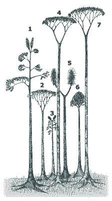
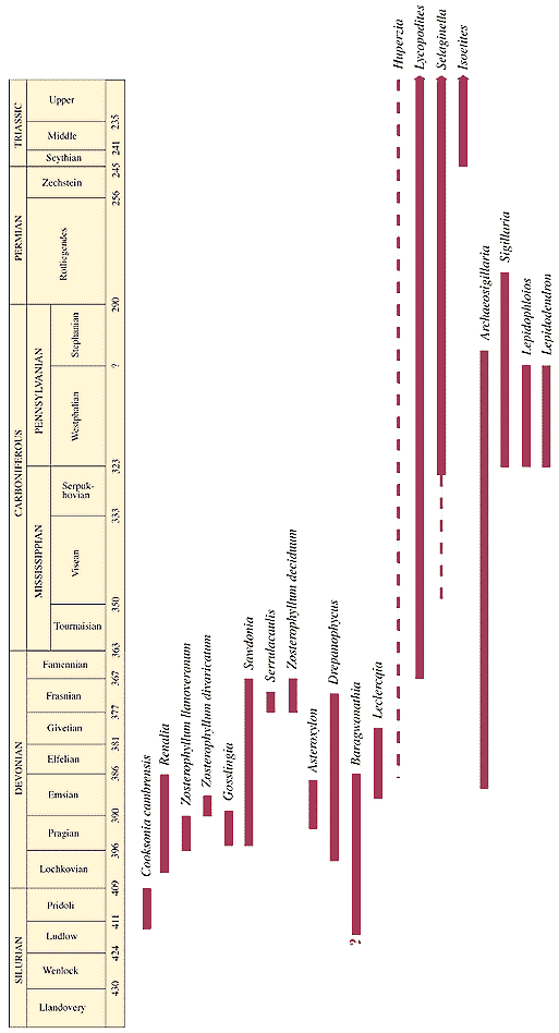
Another problem with the floating forest is that the stratigraphic distribution is the opposite of what we would expect. The supposed floating lycopsid trees are present *only* in the Paleozoic, or early flood deposits, and the angiosperms hardwoods do not even *appear* in coals until the Cretaceous! And to make matters even worse for the flood geologists, the spores of these trees are sorted in the same fashion. There are massive amounts of angiosperm pollen in Cretaceous-Holocene coals and sediments, and there are massive amounts of lycopod spores in late Paleozoic coals and sediments, but not vice versa! Why not? The distribution of lycophytes in the fossil record is illustrated here.
Gastaldo (1984) discusses sundry other problems. For instance, "the reducing conditions necessary for near surface peat accumulation would be greatly influenced by meteoric waters. Fresh water in combination with a tropical climate would promote deterioration and utilization of the plant debris rather than continued peat accumulation."
When Mt. St. Helens erupted in May 1980, numerous trees were uprooted and carried by mud and debris flows to Spirit Lake. Austin (1986) suggests that the Mt. St. Helens eruption provides a plausible analogue for the formation of coal within a flood catastrophe, and boldly claims that "These processes challenge the traditional uniformitariarn way of thinking about how the earth works, and serve as a miniature laboratory for catastrophism." I, on the other hand, find nothing in Austin's work presenting any such challenge.
Austin claims that "several inches" of peat have accumulated on the bottom of Spirit Lake, and that many trees have sunken in an upright attitude to the bottom of the lake. Austin (1996) claims that "If found buried in the stratigraphic record, these trees might be interpreted as multiple forests which grew on dffferent levels over periods of thousands of years. The Spirit Lake upright deposited stumps, therefore, have considerable implications for interpreting 'petrified forests' in the stratigraphic record."
But in fact, the analogy is very poor, and such a model is not consistent with the observed features of most coals. Since we have already described the in situ nature of the root systems and the nature of the paleosols underlying many coals, we will not repeat these observations here.
1. "Several inches" of peat, after burial, compaction and dewatering, would provide only a tiny sliver of coal at best. How many more eruptions and how many more uprooted trees would be required to form a 40 coal seams, each with an average thickness of several meters, seperated from each other by clastic deposits which contain no trees or peat? The actual problem of catastrophically creating the coal-bearing sections is much worse than Austin seems to imply. Gastaldo (1999) notes that this accumulation rate is "far slower than required by the Diluvial model, which requires ten to hundreds of feet of peat to form within hours or days of denudation and transport" (p. 158). And this is considering only single coal seams, not numerous stacked seams as are found in the geologic record.
2. There are no published analytical data on the Spirit Lake peat, but I would willing to bet that the peat contains high levels of volcanic and other clastic detritus. This is in contrast to many "pure" coals in the fossil record, and in contrast to the very low ash, low sulpher domed peats accumulating in equatorial everwet environments today (see Neuzil, S.G. et al., 1993). How would such "pure" peats required to account for many pure coals accumulate from flood waters carrying massive suspended loads of fine sediment? This problem would seem especially acute in the context of Paleozoic coals, which are thought to have been deposited during the violent early stages of the flood.
3. The bark-dominated peats at Spirit Lake are simply not good analogues for most economic coals. Littleton notes that "there are indeed eastern (e.g., Pennsylvanian) coals dominated by bark. However, there the similarity ends as demonstrated by uncompressed plant material preserved in coal balls (DiMichele et al. 1986). First, studies of both coal balls and the enclosing coal clearly shows that woody tissue is either a dominant or major constituent of the coals of the eastern United States. In addition to woody material, significant amounts of herbaceous roots and foliage (leaves) comprise the eastern (Pennsylvanian) coals, unlike the woody material that has accumulated at the base of Spirit Lake (DiMichele et al. 1986). " Another problem is that whereas all the putative peat in Spirit Lake seems to be composed of bark, and the trees in the lake have all apparently been stripped of their bark, we find bark macerals throughout many thick coals. We would thus need a constant influx of of bark into the depositional basin to account for the vertical distribution of bark macerals in coals.
4. How did the trees sink during the flood to allow for burial? The trees at Spirit Lake took weeks to years to sink to the bottom. In fact, many of them are still floating on the lake surface today. This problem becomes worse when we try to use the same floating log mechanism to account for thick, laterally extensive coals. The reason is that the logs float as a single layer, not as massive piles of logs. If you covered Spirit Lake completely with logs, you would not be able to introduce more trees. Instead, you would get a log jam. New trees could only enter the basin once previous trees became waterlogged enough to sink below the water-air interface. Gastaldo (1999) writes that to "amass a floating raft that is more than a few logs thick is impossible physically in a natural confined setting. In an unconfined, one would expect that such a log raft would be dispersed by the currents operating in near-surface waters . . ." (p. 158).
A. Root Configuration
A variety of claims have been made in an attempt to support coal allocthony. Carl Wieland claims that "Water in soil moves downwards under the influence of gravity, so roots growing in soil are designed to send their secondary rootless in that direction, away from the soil surface. By contrast, the rootless of plants floating in water today (equally likely to get a 'drink' whichever way they head) grow straight out from the main root in all directions, just like the stigmarian appendices."
First, Wieland is also making an unsupported assumption about what kind of soils existed in coal-forming environments. Trees growing on saturated substrates, such as exist in peat accumulating environments today, do not send down deeply penetrating roots. If they did deeply penetrate, they would suffocate. The paleosols beneath most coal layers are typical of soils developed in saturated, shallowly submerged environments, thus the roots would not normally be expected to deeply penetrate the soil.
Second, Wieland's suggestion that stigmaria root systems always extend horizontally is empirically false. Although the root systems often extend outwards in a horizontal fashion, they are also found penetrating and cross-cutting underlying sediments at subhorizontal angles, up to 30º or more. Gastaldo (1984) notes:
"The disposition of the stigmarian axes and rootlets within their encasing matrix is an essential criterion for determining in situ growth. . . The contention that stigmarian axes always are buried shallowly, that is, lying parallel or subparallel to bedding, is a generalization. Although specimens have been documented where the axes are buried shallowly (i.e. MacGregor and Walton, 1972; and others), numerous specimens bave been excavated which demonstrate that stigmarian axes also grew downwards at steep angles (i.e. Potonie, 1920; Frankenburg and Eggert, 1969; and others). Sorby (1875) suggested that the difference in angle of penetration of stigmarian axes of individual trees might indicate prevailing wind directions during the Carboniferous. Stigmarian axes which cross cut bedding at angles up to, and in some cases exceeding, 30 degrees and possess perpendicularly inserted, radiating appendages ('rootlets') have been interpreted to represent preservation in a normal subterranean attitude."
And:
"...The proximal axial systems may depart the base at angles up to 30 degrees and the more distal axes commonly cross-cut bedding at angles of 10 degrees or more. This provides for an intertwining of axes at multiple levels, rather than the generally viewed concept of intertwining along a single plane or adjacent planes. The appendages ('rootlets') develop perpendicular to the main axial system and also cross-cut bedding where bedding is preserved."
B. Depostional Fabrics in Fossil Soils
Wieland, following Nevins (1976), also objects that the underclay paleosol "often shows such things as cross-bedding, underwater 'duning', and even 'slump' marks showing that one layer of sediment was deposited while the one beneath was still soft. Undisturbed layering around the stigmarian roots is consistent with their sedimentary burial, not with the intrusion of roots into an already layered soil."
It is simply untrue that soils never display depositional fabrics. There are two seperate things being confused here. The underclay sediment is initially deposited as tidal sediments, and possesses depositional fabrics such as cross-bedding. The soil developoment proceeds *after* these sediments are deposited, and superimpose a variety of features onto these sediments, such as roots and root traces, burrows, authigenic minerals such as siderite, carbonate nodules, etc. In soil environments where the environment is right, the soils are heavily bioturbated by burrows, and thus the depositional fabric is obliterated. However, many soils retain their depositional fabrics for thousands of years, especially submerged soils or soils in reducing environments. And Wieland is just incorrect to say that the preservation of initial depositional features around the stigmaria is inconsistent with their in situ growth, since this very thing can be seen in many places in the modern world.
C. Low Ash-Yield
Discussing a coal seam in Australia, Tas Walker writes:
When the brown coal burns, it leaves hardly any ash behind. The ash produced from most of these coals ranges from 1.5–5%, which is less than the 3–18% ash in typical peat. The low ash is consistent with the vegetation being transported and washed by water, not with lying in a swamp for tens of thousands of years.
Walker clearly displays his ignorance here, on two counts. First, he says that the "low ash is consistent with the vegetation being transported," yet he neglects to explain why he believes this to be the case. My view would be that the opposite is true: the transport and deposition of peat accumulations by flood waters with high suspended loads of fine sediment would *introduce* significant amounts of mineral contaminants into the coal, and would do nothing to account for exceptional "purity".
Second, Walker is either unaware or neglects to mention that many low-ash, low sulpher coals are thought to have originated as domed peats rather than as planar swamp accumulations. Studies of modern domed peats show that they often contain very low ash yield. For instance, Neuzil et al. (1993) studied three domed peats (Siak, Bengkalis, and Keramat peats) from Indonesia, and showed that these often possess very low ash yield, averaging only 1.1% (p. 23), demonstrating that "massive amounts of low-ash peat can develop close to marine conditions and above a marine substrate" (p. 42). In fact, Neuzil and Cecil (1984) and Cecil et al. (1985) "suggested that the domed peat deposits on the coastal lowlands of Indonesia and Malaysia are excellent modern analogues for the low-ash, low-sulpher coal beds of the Lower to mid-Middle Pennsylvanian of the Appalachian Basin. This comparison was based on the deposit geometry, the low-ash and low-sulpher contents of the peat, acid swamp conditions, and the woody and well-preserved nature of the peat" (ibid., p. 25). Grady et al. (1993) have also documented maceral distributions in these modern domed peats closely analogous to maceral distribution in Carboniferous coals (p. 63).
More Problems with the Flood Model
There are various other lines of evidence that are left unexplained by the flood models, but which find simple explanations under the accepted models.
A. For instance, if all the trees and plants found in Phanerozoic coal deposits were present before the flood, we should expect to find a regional rather than stratigraphic correlation of coal types. This would apply to Price's, Morris' Austin's models, in which trees are washed from highland areas into nearby basins, after which they are buried, and the process repeated, until the thick coal sections are formed.
Gastaldo (1999) illustrates the sorting problem by comparing the Cretaceous-Paleocene lignites of the Wilcox trend in Texas and Lousiana with the early Pennsylvanian bituminous coals of the Black Warrior basin. The Wilcox trend contains several coal seams within a 3500ft thick section, and the Black Warrior basin contains about 40 seams within a 12,000ft section. Although these two coal groups are seperated by only about 200 miles in north central Alabama, both coal groups contain *entirely* different floral compositions throughout their lateral extent.
The Wilcox trend coals consist of conifers and coniferophyte wood, and angiosperm wood. These coals contain abundant angiosperm and coniferophyte pollen. The Black Warrior basin coals, on the other hand, consist entirely of typical Paleozoic flora, such as lycophytes, tree ferns, and so forth. "All spores and pollen recovered from these coals represent the lower vascular plant groups; there are no higher vascular plant group pollen, such as that from conifers and or angiosperms, in these coals" (p. 153). Gastaldo goes on to note that "the types of palynomorphs in each of these coal bearing sequences are absolutely dissimilar. None of the pollen or spores in the Wilcox coals can be found in the Black Warrior basin coals, and vice versa" (p. 154).
B. Why are there massive coals on the continents but apparently none in the ocean basins? Even if the trees were somehow able to sink en masse during the flood, we would expect many if not most of them to be washed into the ocean basins rather than piled preferentially onto the topographically higher continental platforms. This consideration will aggravate the already-formidable problem of accounting for all the carbon contained in coals. In their attempts to account for proven coals in terms of a preflood vegetation, flood geologists are already forced to hypothesize a preflood earth packed with massive forests, and floating forests to boot. Yet there is no reason to suppose that the proven coals represent more than a small portion of the preflood vegetation.
C. The idea that the preflood earth was packed with massive forests immediately raises several difficult questions. For instance, why don't we find *any* palynological evidence for these extensive preflood forests? Why no spores, pollen, roots or root traces, woody material or buried trees in precambrian sediments? For that matter, why don't we find any evidence for the existence of forest vegetation in Cambrian, Ordovician, or Silurian "flood" strata? Once coal does appear in the Devonian, what accounts for the stratigraphic distribution of plant types within the flood deposits (see Cross, A.T. and Phillips, T.L., 1990)?
Links
Coal: An Introduction
Atlas of Coal Macerals
International Journal of
Coal Geology
Information on the
Lycophytes
Arborescent Lycopods
Paleobotany of Britain
Picture of Sigillaria
Trunk
Large (180k) Photo of
Lycopod Trunk
Plant Fossils of West
Virginia
Paleozoic Forests:
University of Munster
Paleocene Rocky Mountain
Coals
Polystrate Fossil - Don
Lindsay
Polystrate Fossil -
Andrew MacRae
An Underground Forest
Coal Beds, Creationism,
and Mt. St. Helens
Dinosaur Footprints in
Coal
Powder River Basin Coals
Carboniferous Incised
Valley Systems
Fossils of Nova Scotia
Forests that Grew on
Water
The Origin of Coal
Geological Evidences for
a Flood
The Polystrate Trees of
Joggins
Fossil Cliffs of Joggins
Biostratinomic Processes
in Fluvial Deltaic Environs
Tidal Time - Indiana
Geologic Survey
Allen Archer's Tidalite
Research
High Resolution record of
orbital forcing in a late Paleocene coal
Paleoclimate
reconstruction from Permo-Pennsylvanian Paleosols
Archer, A.W., 1991, Modeling of tidal rhythmites using modern tidal periodicities and implications for short-term sedimentation rates: Kansas Geological Survey Bulletin 233: 185-194.
Austin, Steven A. (1986) Mount St. Helens and Catastrophism. Institute for Creation Research, El Cajon, California, Impact 157, 4 pp.
Cross, A.T. and Phillips, T.L., 1990, Coal-forming plants through time in North America: International Journal of Coal Geology 16: 1-46.
Demko, T.M. and Gastaldo, R.A. Paludal environments of the Lower Mary Lee coal zone, Pottsville Formation, Alabama: Stacked clastic swamps and peat mires. International Journal of Coal Geology. 20:23-47.
Dulong, F.T., and Cecil, B.T. Paleoclimatic Indicators in Paleosols Underlying Pennsylvanian Coal Beds: USA. US Geological Survey; Reston, Virginia.
Gardner, T. W., Williams, E. G., and Holbrook, P. W. (1988) Pedogenesis of some Pennsylvanian underclays; ground-water, topography, and tectonic controls. In Paleosols and Weathering Through Geologic Time: principles and Applications, J. Reinhardt and W. R. Sigleo (editors), GSA Special Paper no. 216, pp. 81-102.
Gastaldo, R. A., 1984, A case against pelagochthony: the untenability of Carboniferous arborescent Lycopod-dominated floating mats. in Walker, K.R., ed., The Evolution-Creation Controversy, Perspectives on Religion, Philosophy, Science and Education, The Paleontological Society Special Publication No.1, p. 97-116.
Gastaldo, R.A., Demko, T.M., Y. Liu, W.D. Keefer, and S.L. Abston. 1989. Biostratinomic processes for the development of of mud-cast logs in Carboniferous and Holocene swamps. PALAIOS 4:356-365.
Gastaldo, R. A., 1990. Early Pennsylvanian Swamp Forests in the Mary Lee Coal Zone, Warrior Basin, Alabama. In. Carboniferous Coastal Environments and Paleocommunities of the Mary Lee Coal Zone, Marion and Walker Counties, Alabama, R. A. Gastaldo, T. M. Demko, and Y. Liu (editors), Guidebook for Field Trip VI, Alabama Geological Survey, Tuscaloosa, Alabama.
Gastaldo, R.A. Regenerative growth in fossil horsetails (Calamites) following burial by Alluvium. Historical Biology 6(3):203-220.
Gastaldo, R.A. 1999. Debates on Autochthonous and Allochthonous Origin of Coal: Empirical Science versus the Diluvialists. in Manger, W.L., ed., The Evolution-Creation Controversy II: Perspectives on Science, Religion, and Geological Education, The Paleontological Society Papers, v. 5, p. 135-167.
Gill, Susan, Keddy Yemane. 1996. Implications of a Lower Pennsylvanian Ultisol for equatorial Pangean climates and early, oligotrophic, forest ecosystems. Geology: Vol. 24, No. 10, pp. 905–908.
Grady, W.C., Eble, C.F., and Neuzil, S.G., 1993, Brown coal maceral distributions in a modern domed tropical Indonesian peat and a comparison with maceral distributions in Middle Pennsylvanian-age Appalachian bituminous coal beds, in in Cobb, J.C., and Cecil, C.B., eds., Modern adn Ancient Coal-Forming Environments: Boulder, CO, GSA Special Paper 286, pp. 63-82.
Joeckel, R. N. (1995) Paleosols below the Ames marine unit (Upper Pennsylvanian, Conemaugh Group) in the Appalachian Basin, U.S.A.: variability on an ancient depositional landscape. Journal of Sedimentary Research, vol. A65, no. 2, pp. 393-407.
Ludvigson, Greg A., Luis A. González, Ronald A. Metzger, Brian J. Witzke, Robert L. Brenner, Angela P. Murillo, Tim S. White, 1998. Meteoric sphaerosiderite lines and their use for paleohydrology and paleoclimatology. Geology: Vol. 26, No. 11, pp. 1039–1042.
Miller, K.B., McCahon, T.J., and West, R.R., 1996. Lower Permian (Wolfcampian) paleosol-bearing cycles of the U.S. midcontinent: evidence of climatic cyclicity: Journal of Sedimentary Research 66: 71-84.
Miller, K.B., and West, R.R., 1998. Identification of Sequence Boundaries within cyclic strata of the Lower Permian of Kansas, USA: Problems and Alternatives. Journal of Geology, 106: 119-132.
Mossbrugger, V., Gee, C.T., Belz, G., and Ashraf, A.R. 1994. Three-dimensional reconstruction of an in-situ Miocene peat forest from the Lower Rhine Embayment, northwestern Germany; new methods in paleovegetation analysis. Palaeogeography, Palaeoclimatology, Palaeoecology, 110: 295-317.
Neuzil, S.G., and Cecil, C.B., 1984, A Modern Analog of low-ash low-sulpher, Pennsylvanian Age coal: GSA Abstracts with Programs, vol. 16, no. 3, p. 184.
Neuzil, S.G. et al., 1993. Inorganic Geochemistry of domed peat in Indonesia and its implications for the origin of mineral matter in coal, in Cobb, J.C., and Cecil, C.B., eds., Modern adn Ancient Coal-Forming Environments: Boulder, CO, GSA Special Paper 286, pp. 23-44.
Nevins, S.E. 1976. The Origin of Coal. Impact 41, Institute of Creation Research.
Snelling, A. Coal Beds and Noah's Flood. Creation Ex Nihilo 8(3):20-21, June 1986.
Scheven J., The Carboniferous floating forest — An extinct pre-Flood ecosystem, CEN Technical Journal 10(1):70–81, 1996.
Neil Tabor and Isabel Montañez. 1999. Early Permian Atmospheric pCO2 Reconstructed from Paleosol Carbonate: Implications for Late Paleozoic Degalciation. 11th Bathurst Meeting, Cambridge. Volume 4 Number 2.
Tessier, B., et al. 1995. Comparison of ancient tidal rhythmites (Carboniferous of Kansas and Indiana, USA) with modern analogues (the Bay of Mount-Saint-Michel, France). Spec. Publs int. Ass. Sediment. 24:, 259-271.
Walker, T. Coal: memorial to the flood. Creation Ex Nihilo 23(2):22–27, March–May 2001.
Wieland, C. Forests that Grew on Water. Creation Ex Nihilo 18(1):20–24, December 1995–February 1996.
