Seven Arches Logo

Canal Feeder - Page 1

Home Page Back to Home Page

OS Map Ref SD 797 130


Providing Water for the Manchester, Bolton & Bury Canal

All canals need a source of water to supply that lost when locks are operated. A standard canal lock is at least 70 feet long by 7 feet wide with a drop of about 6 feet. This means it transfers over 60 tonnes of water from the higher level to the lower level each time it is used.

The Manchester, Bolton and Bury canal obtained its Act of Parliament in 1791 and was opened in 1797, being extended to meet the Irwell at Salford in 1808. From its start at Bury Wharf the canal manages to reach Prestolee on the outskirts of Little Lever, a distance of about 5 miles, before the first flight of locks.

The main water supply for this canal is Elton Reservoir near the Bury/Radcliffe border, but this has only three small natural streams flowing into it, which would not have provided sufficient water when the canal was operating commercially.
Thus a feeder was built to carry water from the river Irwell to replenish the reservoir. Unfortunately the river is well below the level of Elton Reservoir where they are close together and so the feeder has to start a long way upstream, in an area known as Burrs.
The straight-line distance from the start of the feeder to Elton Reservoir is 3¼ kilometers (2 miles), but because of its meanderings the total length of the canal feeder is 4 kilometers (2½ miles.)

Burrs is at the end of Woodhill Road, which starts near the junction of Crostons Road/Brandlesholme Road.
The feeder can be traced from its source at Burrs, along Woodhill Road, under Brandlesholme Road, Tottington Road, Walshaw Road, Ainsworth Road and Bolton Road then finally alongside the former Bury-Bolton railway line (now a cycle path) until it empties into Elton reservoir.


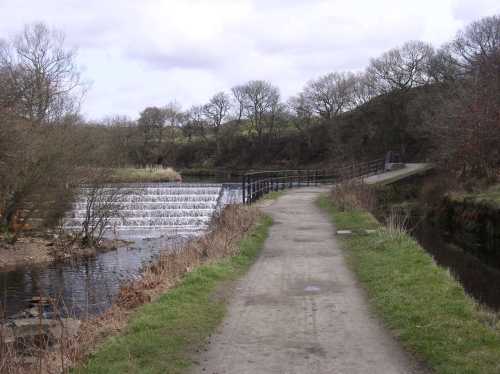
The beginning of the canal feeder can be reached from Burrs Country Park by following the footpath, helpfully signposted "Weir", between the river and the water channel.

The feeder starts at the top of the weir in this picture and flow is controlled by sluice gates, the mechanisms for which are just visible to the right of the picture.

Weir at Burrs


A close-up of the control gear.

Sluice gate controls


The feeder is an open channel like a narrow canal leading off from the left bank of the river. This shows the start of the channel next to the weir and the openings from the sluice gates can be seen in the left wall. The waterway was clearly constructed to last and at this point is lined with blue engineering bricks.

Canal feeder source


The feeder then runs parallel to the river but at a higher level back towards the site of Burrs Mill, the chimney for which (dating from about 1850) is visible in this photograph.

Burrs Mill was originally a cotton-spinning mill, started by Haworth Yates and Peel in the 1780s. In the 1880s it became a bleach works.

Canal feeder near Burrs Mill


Home Page
Home Page

Next Page
Next Page


Hosted by www.Geocities.ws

1