|
Time finally to finish that missing section: Kinsman Notch to Franconia Notch. We didn’t do it last year (with the western New Hampshire hike) because of heavy rain. And we didn’t do it earlier this year (with the Crawford Notch to Franconia Notch) because, frankly, we were aching badly.
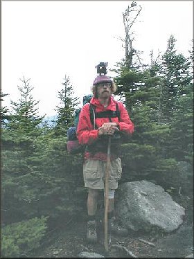
8/23/02. Friday. Day 1. Temp 60-75. Bright and sunny. It had downpoured the previous day. 8.0 miles. 8 hours. That’s 1 mph folks. Kinsman Notch to Eliza Brook Shelter. Yes, we’re northbounding this section. The Kinsman Ridge Trail. Hiking with my sister, Joan (Goes in Circles), of course. 2280’ of climb. Steep and overgrown, but not difficult climb up the cliffs. Meandering up and down the ridges of Wolf Mountain.
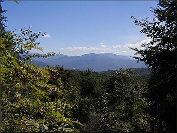
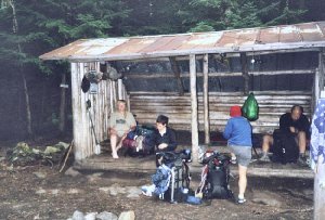
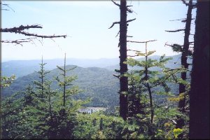
Some nice, but hazy, views east to the lower part of Franconia Ridge, and Mt. Coolidge and Loon Mountain Ski Area. Rocky, and somewhat tiring with the constant ups and downs. Passing hikers, and groups told us that the previous evening there had been twenty-five people at Eliza Brook Shelter in the pouring rain. Nine of them camped under tarps. The shelter only sleeps 8 comfortably, and that’s with two sleeping on the lower section. Patrick (who passed us on the hike in
8/24/02. Day 2. Temp 50-65. Overcast. 8.3 miles. 10 hours. Hmmm… That’s .83 mph! But there’s a reason. 2000’ to the top of South Kinsman, and another 520’ over North Kinsman, and other climbs. The ATC guide book says “Allow considerable extra time on the segment, especially with heavy packs.” The book did not lie. We were overnighting, but only one night, so our packs were probably about 30 pounds. Eliza Brook is a beautiful little mountain stream. It’s wide, to carry the runoff from the winter snows, but shallow this time of the year. It feeds from a spring a thousand feet up the mountain. Steep, rocky, but not a bad hike up Eliza Brook. It burbles, and splashes in short falls. Then. Then starts a steep climb up rock steps, and angled slabs. Nothing too difficult, but somewhat frightening with the pitch. I say “Hmmm” when a difficult climb appears before me. Circles gets worried every time she hears me say “Hmmm” or “Ooh”.
We finally hit a marshy spot at Harrington Pond (which flows down a different side of South Kinsman). And THEN we start climbing! Now we’re cliff climbing, swing up on trees, or climbing steep slabs. “How did you get up this one?”
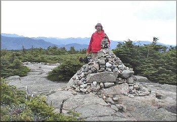
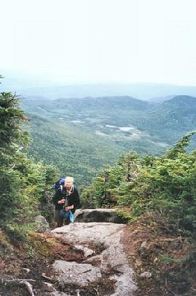 Steep climbing, with spectacular views behind us. Hey, you climb 40’ up a slab, there ain’t no trees behind you, so there’s a view. Views of the Big Moose (Moosilaukee). Views to the south end of Franconia Ridge. Then we hit a false summit. It looked like it should have been the summit as we climbed, but it was just a level spot before the next climb. The ubiquitous bunchberry is here, but not as prolifically as last year in western New Hampshire. The bunchberry now has berries, reddish-orange berries. 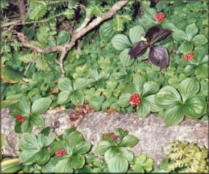 Another flower is in bloom. Tall stalk (about two feet high) with single long ovalish leaves up the stalk, and clusters of yellow star-like flowers up and down the stalk. Clintonia lily is also in the berry stage. There’s another 280 foot climb up the cliffs to reach the top of South Kinsman Mountain. The predominate trees here are red spruce and silver birch. No old growth trees. This mountain must have been clear cut back in the early 1900’s. As we approach the top, the red spruce are shorter and shorter. Because of the winds none of the tall mountains have tall trees at the top. Tallest tree here is 2 or 3 feet tall. Two and a half miles, two thousand feet of climb, three hours and twenty minutes! This was a tough climb, but we’ve bagged another 4!! The South Peak of Kinsman Mountain, 4358’. Spectacular 360 degree views, of Moosilaukee and the Green Mountains of Vermont, including Mount Mansfield to the west.  Gorgeous views of the southern part of Franconia Ridge to the east. Brisk winds and cool temperature. And we rest. I seek cover by the two foot tall red spruce. I guess my mommy did raise some mountain goats after all. A fairly steep and rocky climb down South Kinsman to the col.
And another fairly steep slabbing climb up North Kinsman. The North Peak of Kinsman Mountain. 4293’. And yet another 4!!!!! My 10th and 11th 4000’ mountains in New Hampshire. Finley Dolphin is quite proud of himself!
 For Joan, these are numbers 24 and 25. She’s more than halfway done bagging the 48 4’s in New Hampshire!!!!!! There are quite a number of day-hikers on both these mountains. These are much easier to climb from the Lonesome Lake Hut or climbing up from Route 3 from the east. But I’m hiking the AT, and I needed the section. There’s some discussion as to where the exact top of this mountain is. Comparing notes with other hikers, and their guide books, and looking around, we determine that the top of North Kinsman is a large pointed boulder. First mountain that I’ve climbed with a boulder as the high point. Another spectacular 360 degree view. Of South Kinsman, of Franconia Ridge. We’re both quite sore by now. These were some very difficult climbs. Another tough slabbing climb down to Kinsman Pond. Here we pick up the Fishin’ Jimmy Trail. (It’s all the AT, but the AMC uses it’s own trail names. AS long as it’s blazed in white, we’re on the right trail.) More rocky, boulder-strewn or slabbing descent to Lonesome Lake, and the Lonesome Lake Hut. Lonesome Lake is a beautiful lake between two ridges of North Kinsman. The outlet is called Cascade Brook.
We hike down Cascade Brook Trail. Very rocky and slow progress. I’m very tired at this point. My sister is leading. After we cross Cascade Brook, hopping on granite boulders, we finally hit an easy section of trail. An old woods road. We are overtaken by a thruhiker who has spent the previous night stealth-camping at Gordon Pond.
 He and my sister go gallivanting off ahead. I never did catch his trail name. WE promise him a ride into town (which means he has to hike as slowly as we are). Nice easy descent to Whitehouse Brook, and under I-93. One mile hike along the bicycle path to the parking area. We’re both very tired, and sore. I drop my sister off at Woodward’s to check in, and drive the thruhiker to North Woodstock, where he’s hoping to find a cheap motel for the night. We had carried seven liters of water from Eliza Brook, and we had drunk almost all of it, despite the fact that the temperature never got over 65, and it was overcast all day. That shows how hard this section was. Our friendly thruhiker is used to hiking twenty miles a day. He said “It took me all day to hike thirteen miles. This was a very difficult section.” We’re very glad we did this section as a long weekend (despite the 7 hour 15 minute drive for me each way). It was a hard section. And again, we’re very glad we did it northbounding. We did enough butt-sliding northbound. Southbound might have been too frightening for me. That’s one of the joys of section-hiking: We get to choose which way we want to hike each section.

 This page hosted by Get your own Free Home Page Free search engine submission and placement services! |