Famous Valleys of
District:
![]()
![]()
Mansehra is known as the district of valleys. There are five main valleys in this district. which are as under
AGROR VALLEY:
This is a comparatively small valley lying between Kala Dhaka and the Pakhly plain, surrounded by mountains of various altitudes ranging from 50000 feet to 90000 feet. It is not homogenous valley but a combination of three beautiful glens meeting at the central town, Oghi . The Dilbori dale extends towards the north, the Kathai towards the east and the Arbora dale towards the south. Its maximum length is about 21km and breadth is 18 km. It comprised of a total area of about 66 sq. miles. The land is fertile and Unhar is the major water source.
BHOGARMANG VALLEY:
Bhogarmang or the Siran valley is ordinarily considered as a part of Pakhly plain rather then being a separate geographical entity. It is a narrow tract of about 50 km length. It is enclosed on the three sides by the snow capped mountains but no natural boundary demarcates it from Pakhly. It is divided into two glens, one is Panjool section and the other is Devli section, beyond the Sachan village. Jabori is the central place while Bhogarmang and Dadar are other important villages in this valley.
KAGHAN VALLEY:
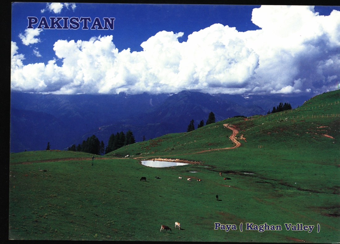
Kaghan valley is the most prominent in the physical features of this district. Its importance for its botany, science beauty and geography can not be denied. It lies in the north eastern portion of the district and like a spearhead penetrates for into the heart of Himalayan system. It is a wedge between the Kashmir on the east and territory of Batagram, Mansehra and Kohistan district on the west. It also touches the Diamer district in the extreme north through Babusar Pass. The total area of the valley is estimated about 800 sq. mile with maximum length of 60 mile and an average width of 15 mile. Average elevation of the valley from the MSL is about 6690 feet while somewhere it also reaches to the height of above 17000 feet. Population mostly consists of scattered villages and tiny hamlets studded on the mountains slops. A road of about 92 miles connects the valley from Balakot to Babusar pass.
The valley is bestowed with a rich treasure of flora and fauna but cultivation and crop growing system is not so convincing, only 3% of land is under cultivation. Most of the area is under forests, lofty mountains with everlasting snow, flanks on either side of valley while Kunhar river traverses in the middle.
TANAWAL VALLEY:
It is not a regular valley but network of small plain valleys, steep hills and passes studded small villages. Due to its geo-political integration, it is considered as a physical unity. Geographically it is U- shaped valley with two horns, one Shergarh-Durband while the other is Parhina-Lassan horn, connected by a narrowpass, Gali Badral, of about 10 km length .Total areas of all the three sections is about 200 sq mile
Which is mostly mountainous area, Bhingra is the most important ridge with 8500 feet elevation. The Siran and the unhar rivers traverse its eastern and western portion respectively. Soil is poorer for cultivation with few exception , is not so efficient. Once the whole valley was the property of two feudal , khan of Phulra and Nawab of Amb but now rights of ownership have been transferred to inhabitants who are mostly belong to Tanoli tribe.
KONSH VALLEY:
Another small beautiful valley at the head of Pakhly plain is KONSH. The southern boundaries of this valley are not well-defined. An off shoot of Siran mountain system Skirts its eastern boundary with Bhogarmang valley. Agror valley is situated in the west, Tanglai is in the east where the Battal mountains form its northern and western boundaries. It is divided into two parts. Bar Knosh (Upper Konsh) and Kooz Konsh (lower Konsh). Battal is the central village while Qaziabad, Ahl, Serian Chinar Kot and Hairan are other important villages. Batkus is the major source of water in this valley.
Besides these, there are a number of vales and dales in this district but Mangal at the border of Abbottabad and Mansehra district and Nane Sukh at the foot of Kaghan valley are other notable valleys.
Copyright or other proprietary statement goes here.
For problems or questions regarding this web contact
[email protected].