To next page
Qutb al-Din al-Shirazi (1281) Nihayat al-idrak fi dirayat al-aflak (in the complete understanding of the spheres) from Persia
--------------------------------------------------
Taken from: Journal Asiatique
The equator starts in the west of China and passes by an island that the Indians call Jankut, then by the southern parts of China, then by Dixhank, by the island of Zawa which is called the gold island, then by the south of the island of Sirandib, between the islands of Kalah and Sribua, through the Diwa islands, on the north of the islands of the Zanj, and to the north of most of their country. After having crossed the border of their country through the desserts and steppe of the Negroes, to the north of the mountains of Komr, to the south of the Negroes of the Magrib.....
----------------------------------------------------------------------------------------------------------------------------
Qoutb al-Din al-Chirazi; Al Touhfa al Chahiya fi l-Hai�a
(The royal gift about astronomy)
Taken from: Youssouf KamaltomIVfasc1
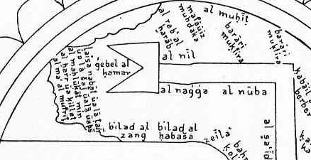
The sea�.. that is part of the south western quarter continues towards the country of Soufala al Zandj which is the extreme end of the ships of Oman and Siraf in the furthest places of the Zandj. The bigness of the sea, the darkness and the big waves make navigation impossible once passed this country because if they pass they sink. Because of that it is not clearly known how this sea connects with the all encircling sea�.. this sea goes to the south of the equator where she passes behind the snowy mountains called Mountains of the Moon where are the sources of the Nile of Misr. She then continues to al-Soufala without that the connection with the encircling sea is known��
The Barbari gulf forms a triangle�.. on the western leg of the triangle are situated the countries of the Habacha infidels, part of the Zandj, and towards the east the land of the Habacha Muslims�.. the side of the continent, a part of the lands of the Zandj and the Habacha, here is situated Maqdichou opposite Zafar or al-chihr�.
Then the islands of the Zandj, which are very numerous, like the island of Qanbalu situated at 1 or 2 days distance of the Zandj coast; its people are Muslims who settled there in the beginning of the Abbasid period. The water of this island flows into the sea of Oman; this country is at about 500 farsakhs distance. It is here that a branch of the Nile reaches the sea. The navigators on the sea of Oman say that during the floods of the Nile the effect is felled in Oman. The people of Mogadishu take profit of this branch of the Nile to water their crops and because of that their sugarcane and other crops are better there then anywhere else in the Soudan. To this reason the traders say is due their affluence and the floods or shortage of the Nile is a very sensible subject to them. There are however people that deny that a branch of the Nile goes down towards Oman but they have no reason to stand on�.
The Nile has its origin in the mountains of the moon. First its 11 rivers that join in a swampy lake. Then they go through the sand and mountains of the region, and then the land of Nakta, black people like the Zandj and in the land where the gold grows. There it splits in two of which one branch goes to the sea at the island of Qanbalou as we already said. This branch goes through most of the land of the Zandj long and wide, from that branch to the land of Soufala is about 700 farsakhs�.
The first clime starts�. Through the islands of Diwa and the northern part of the islands of Zandj and the biggest part of the land of those people. After the Zandj it reaches the Soudan from where the black eunuchs come then north of the mountains of the moon�.The inhabitants �. Have often defects in their natural qualities what is proven with the ugliness like the Zandj and the Habacha in the first clime.