To next page
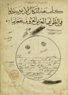
Ibn Said al Maghribi (1250) Kitab Djoughrafiya fi l� aqalim al Sab (Book of maps of the seven climes) born in Spain
---------------------------------
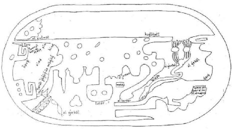
The map to the left is a map of the Indian Ocean. The original manuscript of Ibn Said had no maps. The once given are added in later centuries in copies of his work. They originated in Ibn Hawqal's work

Mostly taken from : Neville Chittick:East Africa and the Orient.
E.J.Brill ;The encyclopedia of Islam; 1984
M Guillain; Documents sur l'histoire, la geographie
Youssouf KamaltomIVfasc1
Third section:
Since the beginning of this section where the longitude is 36 deg and some min up to 39 deg 20 min longitude and 16 latitude are the sources of the Nile who come after the 5 rivers mentioned in the last part of the second section. These sources start off in the plains. The sources of the 5 other springs are also in the third section but they come out of the Djabal al Qoumr at 48 deg to 52 deg 5 min longitude as to latitude for t he 10 springs they are 16 deg. The 5 first rivers go to the first lake, west, with centre at 42 deg longitude and 7 deg latitude diameter 5 deg. Second lake, east, is at 2 deg distance of t he first with same latitude and diameter. From each lame leave just as there enter 5 rivers on the north side, only the second and third river become together one river. All reach a big lake with centre in the first clime. In this third section are the towns of the Soudan. Rafla between the two first rivers and at one deg distance of the lake then Koucha at the sources that feet the last river coming from the 2nd lake at 53 deg and 2 deg latitude. Above this place passes the Nile of Maqdachou that comes from north of the equator. The people of Qoumr are between the two lakes and those of Akwan are north, in the direction of Koura.
Fourth section
In this section ends the Djabal al-Qoumr according to Ptolemy at 61 deg 50 min longitude (mss London 46 deg / Paris 51 deg 50 min) and lat 11 deg (mss London 16 deg) al Baihaqi and ibn Fatima make them join there the mountain that stretches along the first regions that are inhabited up to Djabal al Nadama�� along this mountain live the Qoumr��
Dandama/Damadim 54deg 20 min longitude, 9deg 30min latitude
Qaljur, near which are iron mines (ma'din hadid fa'iq), source of the material from which
the Qaljuriyya swords are made 56deg longitude, 2deg 30min latitude
....Berbera, (Qa'idat al Barabar) the capital of the berbers, of which Amou-el-Qis described the slaves and horses. who are considered really good. Most of those people did become Muslim by now. This town is at 68 deg longitude and 6 deg 30 min latitude. The Nile of Maqdishu from where it leaves lake Koura continues ascending in this section up to 11 deg lat. and 66deg long. then swings round to the east (south) of Barbara from which it is separated by a degree; then curves to the east (south) of Maqdishu.
In this section among the towns of Berbera and after Berbera, which is the capital, one finds on the Indian Ocean shore: Serfouna or Carfouna (or Qarquna/Farfuna), which is placed in a bay at the beginning of that sea, 64 deg 30 min longitude and 0 deg 20 min latitude. More to the east is another town of the Berbers, called Berma, (Barma) also located in a bay at 66 deg longitude and 1 deg latitude. Further to the east is Llhafouny (Hafuni, Ras Hafun), a big mountain very well known by travelers. It seems like it goes into the lands towards the south for a distance of 100 miles. At the same time it also goes into the sea for about 140 miles, in a northerly direction, with an inclination to the east. In that part that you can see, there are 7 peaks, the sailors count them and are happy when they are past. Marka, to the east (south) of Hafuni, in the celebrated land of Barbara, on the seacoast is found Marka whose inhabitants are Muslim. It is the Capital of the country of the Hawiya which contains more then 50 villages on the banks of the river branching out from the Nil Maqdishu 69 degrees 30 min longitude 1 degrees 10 min North latitude It is placed on the side of a river that comes out of the Nile of Magdachou and has its mouth at 2 marhala to the east of the town. Out of that river comes an arm that forms close to Meurka a sort of gulf. At the east of Meurka is the Muslim town of Magdachou (madinat al Islam) celebrated in this region whose name Maqdishu occurs frequently on the lips of travelers.... 72 degrees longitude, 2 degrees latitude at the Indian Ocean shore, its harbor offers little security.
The Damdam live on the shores of the Nil behind the lands of the Zeng. They are the Mongols of the Sudan. They pull out against them and kill them, like the Mongols do with the Muslims. They are careless in their religion. They have idols and religious ceremonies. In their countries there are giraffes. It is in the land of the Damdam that the Nil splits. They live there where Ahmad b. Tulin the Bukna puts. These live behind Alwa and are completely naked like the Zang. It is in their country which produces gold, that the Nil splits in several branches . Out of which the green and the white Nile are born.

At the beginning of this section at 0 deg, 10 min (still of the former section ) and at 2 deg latitude is the mouth of Nil Maqdishu, which flows through the lands that belong to the town with the same name. At about 12 miles from it and then mouths into the sea. Close to Maqdishu it looks like the river is less big then the Nile of Egypt, but it is deep and it lost lots of water on the way, giving birth to other rivers. Ibn Fathima says: This Nile comes from lake Koura, situated under the equator, and out of the mountain El-Moquecem. This Nile then becomes a twin river to the Nile of Egypt, the bifurcation is at 51 deg longitude and 0 deg 30 min latitude in the first climate to the north of the equator. The river is curving around instead of going strait, other rivers leave it who go and make the surrounding country more rich as happens in Egypt for the sugarcane and the banana and in India for the pepper the m'qeul (the cocoa-tree) the foufeul (palm-tree) and others. The people of the land plant twice a year: once just after the floods of the river, one uses this water to irrigate the terraces, the other, when the rain season has arrived. The river after running for about 2,000 miles mouths at the east of Magdachou. At the eastern side of the Nile ends the land of Berbera (Bilad al Barbariyya) and begins the land of the Zendj. (Bilad az-Zanj).
One finds in this 5th section among the well known towns of the Zandj Mulanda- Malindi at 81 degrees 30min longitude 2 degrees 50 min latitude. It is situated in a bay west (north) of it is a khor (estuary) of a river (Jabal al-Qamar) coming from the mountains of Comr. On its banks are habitations of the Zanj and to the south (west, inland) those of the Qamar. To the east of Malindi is Alkerany (Kharani), a jabal (mountain) known to travelers. This mountain goes into the sea for about 100 miles, in north-east direction and at the same time it goes in strait line into the country in southerly direction for about 50 miles. Among the special things of this mountain is: on the continent side of it is an iron mine producing enough for the whole country of the Zendj as well as for export. The other side, in the sea, is magnetic. One finds at Malindi the tree of the Zandj (or another translation reads: one finds sorcerers) The king of the Zanj lives in Mombasa (Manbasa) a degree from Malindi. Mombasa is on the sea shore. To the west is a gulf that the boats can go up for two days. And which is more then 300 miles long. In this section is also Mafaza the uninhabited stretch between the Zanj and Sofala.
Then we have the towns of Sofala. Banyna, (Batina) (Idris Bathana/ at-Tuhnat) at the extremity of a big gulf that goes into the lands up to a distance of 4 deg. from the equator. And of which the opening is 2 deg. longitude. The town is at 87 degrees 10 min longitude 2 degrees 30 min latitude...To the west of Banyna is Jabal 'Ajrad (or al-Mujarrad) a mountain that goes into the sea, towards the north east, up to 100 miles. The sea here makes a lot of noise, and the mountain sucks to it everything that comes close. Travelers really are very scared of it, and watch out. Banyna has a quite long bay into which comes a river that comes from the mountains of Comr, which are in the east. The length of the bay and the river is of one month traveling. On it's shores are many houses and trees.
Section 6
In this section are the inhabited regions of the Sofalans that are on the board of the Indian Ocean. And also some of their towns that are not well known; then comes the capital, which is Sayouna at longitude 99 deg and latitude 2 deg 30 min situated on a big gulf where descends a river from the Djabal al-Qoumr west of the town, in an immense bay east of which is a town: the length of the bay, along the equator is 5 and a half deg. In this town lives the king of the Soufalas. These and the Zandj are idolaters and pray to stones which they sprinkle with oil from big fish. Their mean income comes from gold and iron. Their clothes are made of panther skins. Horses don�t live in their country so that their soldiers go on foot. Al Masoudi says that they fight on the back of bulls as the Nuba use camels. East of this town is the canal of al-Qoumr coming from the sea of Hind up to the last inhabited places in the south; it stretches there about 200 miles it keeps going that way making an arc, towards the south east till it touches the Djabal al Nadama, talked about later. East of al Sayouna is the mountain al Maltam this one is big and stretches along the coast for about 260 miles, it happens often that ships that got shipwrecked by the north wind are destroyed there, travelers watch out for this mountain, when they pass it towards the east they are saved and when they enter the channel in the south they try to use the south wind to get out so that the water and the wind does not bring them to the Djabal al Nadama which would kill them.
The people of Al-Qoumr are in the south of this section where they are close to the mountain that is called after them. One of the towns in this section, who are on the island of al-Qoumr- an island wide and large and of which it is said 4 months long and 20 some days wide- is Lirana. Ibn Fatima says he visited it and that it is from the Muslims as Maqdachou. Its people come of all places. It is a place for loading and off loading; its nobles who make up the government are under the king of Malay which is to the east of t heir town. Lirana is situated at the shore at 102 deg longitude less some min. and 0 deg 32 min latitude: it is in a big gulf in the river, coming from the mountain situated in the 7th section descending west of the town. At 5 deg distance of it is the town of Malay where the king of the island resides. It is possible that he is a sultan with authority over the whole island or a big part of it but that is not important, because of the big distances and the differences in opinions and parties. This town is on the same latitude as Lirana: west is a gulf which is a derivation of the big river which descends to Lirana.
There are no Chinese. They dwelt originally with the Chinese in the eastern regions of the world, that is to say, in the interior of the continent of Asia. Discord having broken out between them, the latter drove the Kumr towards the islands. After a certain period of time, with dissention erupting among the Kumr who had emigrated to the islands, the king and his family emigrated again made their way to the large island of Kumr (Madagascar) And the king established himself in a town of this large island called Kumriyya. These Kumr, having arrived on the large island, grew in number and proliferated in the various capitals of the island in question. But new dissentions provoked a new exodus and a large number of them departed to settle in the south, at the commencement of the inhabited territory, along the mountain range which bears their name. (this paragraph is taken from Encyclopedia of Islam)
Seventh section
In this one ends the continent of the Soudan which stretches from the extreme west up to Djabal al Nadama, further on the sea covers all that is to the east, at the longitude of the island of Qoumr. The beginning of Djabal al Nadama is the beginning of this section at 108 deg and a min longitude, it is said that it goes up in the air for three days in height. Its color is a mix of dust and red and it stretches along the limit of the inhabited places at 16 deg lat for about 20 days of these about 14 days along the sea, its end is at 117 deg 30 min longitude. The sea al-Mouhit coming from the south-east reaches its southern part, in the north is the channel of Al-Qoumr. When a boat from the sea of Hind enters this channel the waters and wind pouch it till you see this mountain, one regrets not to have taken precautions and accepts the fatality, then one gets shipwrecked, or one gets behind the mountain after which there is no more news about the ship, and it is unknown what has happened, it is said that there waves that don�t stop turning the ship till it submerges. The travelers on the sea of Hind call this place the sea of destruction and sea of Canopus because when entering Canopus is seen above the heads. Under this mountain, in the channel of al-Qoumr is the town of Daghouta last town of Soufala and last place inhabited on the east coast which goes on till the (surrounding) sea. She is situated at 109 deg longitude and 12 deg latitude in the north there is a gulf where descends a river from the mountain of al Qoumr, it is said it has the same source as the river of Sayouna.
Among the towns and islands of al-Qoumr who are the residence of their kings and who are in this seventh section is Daemi at 112deg 30 min longitude and 3 deg latitude. East of this town descends a gulf fed by a big river: this gulf is bend in an arc and the sea enters along the town till it touches close to the equator. At the end of the arc is situated the town of Balbaq also one of the residences of there kings of the island at 118 deg 30 min longitude and 1 deg latitude. In the east is an island that is called after the town, this island is about 2 deg long west to east and wide about 1 deg. In the east of Balbaq is a big river shaped in an arc, this is the river of Lirana, it descends from the Djabal al Ouyoun 8 days long on foot from east to west, from its sources descend 5 small rivers up to the bend of that river, then the bent continues up to the sea of Lirana and the sea of Balbaq�.
Section 8
Towns of Qumr, continued
Section 9
Towns of Qumr, continued, Old capital Qumriyya.
Account of the Qumurians, boats, buildings and so forth.
The Kumr who have given their name to the mountain of this name situated in eastern Africa are brothers of the Chinese. They dwelt originally with the Chinese in the eastern regions of the world, that is to say, in the interior of the continent of Asia. Discord having broken out between them, the latter drove the Kumr towards the islands. After a certain period of time, with dissention erupting among the Kumr who had emigrated to the islands, the king and his family emigrated again made their way to the large island of Kumr (Madagascar) And the king established himself in a town of this large island called Kumriyya. These Kumr, having arrived on the large island, grew in number and proliferated in the various capitals of the island in question. But new dissentions provoked a new exodus and a large number of them departed to settle in the south, at the commencement of the inhabited territory, along the mountain range which bears their name.
Climate I
Third section
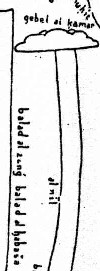
In this third section is the lake Koura from where comes the Nile of Misr, the Nile of Maqdachou and the Nile of Ghana�..
The origin of the Nile of Misr is in this section; it comes out of lake Koura at 51 deg 30 min longitude and latitude 6 deg. There where it leaves the lake is the city of Koura, from the cannibalistic Soudan; this town is on t he North-West of the Nile where is the mountain al-Mouqassam, which extends towards it leaving from the south-eastern corner of the lake. The Nile of Maqdachou also comes from underneath this mountain close to the equator and from behind the equator.
Fourth section
To the south-east of this town (Donqoula) are the habitations of the Zandj from among the Nouba�.
The land of the Kazla stretches from the equator close to the Zandj and the Habacha up to the southern side of the mountain Mouris where there are gold and silver mines�.
In the south east of Kazla is the lake of Hawars; this lake is called after one of the Zandj groups who belong to the Habacha, who are naked and wild. It is said that gold and lead are very common in their land �..
Donqola, qa'idat an Nuba at 58 degrees longitude 14 degrees 15 min latitude.
Nawaba 58 degrees longitude 9 degrees latitude.
Kusha, capital of Majalat Zanj an Nuba, Khalf al-istiwa, situated behind the equator.
Alwa = capital Soba at 57 degrees longitude 16 degrees latitude
Tajawa; Qa'idat az Zaghawiyyin. Muslims under the control of Kanem at 55 degrees
longitude 14 degrees latitude
Madinat Zaghawa at 54 degrees longitude 11 degrees 30 min latitude.
Among the Abyssinian towns in this 4th section are....
Junbaita at 58 degrees longitude 3 degrees latitude.
Country of the Kazia (read Karla, Karka)
Jabal Mawrus/Mawris
Buhairat al-Hawrus/Hadrus, named after a tribe of Zunuj al Habasha at 62 degrees
longitude 2 degrees latitude.
An-Naja'at, to the east of Nil al Habasha, beside the lake at 61 degrees longitude 2
degrees latitude.
Markaza/Markata, on this Nil at 62 degrees longitude 6 degrees latitude.
Bilad Saharta
Kalghur at 63 degrees longitude, 10 degrees latitude.
Bilad al-Khasa, to the north of Saharta between the Nile and the Sea
Samar (Samhar)
Bakhta, east of Kalghur at 65 degrees longitude 12 degrees latitude.
Jabal al Khamahin, west of Bakhta
Bata at 64 degrees 30min longitude, the first place on the Indian Ocean, marking the
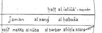
boundary between Bilad al-Habasha and Bilad al Barbara, and situated just behind Khatt
al- Istiwa. (Ibn Said says a little bit further on that Bata is situated 2 degrees from the khaff meaning the line of climate.) (some authors say Bata = Pate )
Baqati/Baqati, north (this is east) of Bata, 100 miles.
Mount Manquba at 65 degrees longitude 8degrees 30 min latitude
Mount Maqurus at 66 degrees longitude 11 degrees latitude
Jazirat Qanbalu: Among the islands of this sea mentioned in the books neighboring the coasts of al-Habasha is the island of Qanbalu. between it and Baqati are 2 degrees 30 min. Its southern point is on the same parallel (as Baqati), and its length is about the same as its breath, around two degrees. The distances between its north-eastern part and Aden is 4 degrees 30 min. It used to be prosperous but is now derelict. Boats that have been carried off their courses and have need of water and firewood take refuge there. It is recorded that the extremity of Bahr al-Hind, where are located the Abyssinian towns mentioned... situated just a little off the Sawahil, consists of reefs and rocky stretches where the water is shallow as far as Bab al Mandab where none except small boats can sail.
Section 5
South Arabia
..........
At the end of the first climate is a sea were are situated the islands of Mend (Djezair-el Mend or Jaza'ir al Hind/Mand) which are known for the big amounts of coconuts that are found there. The most special is called the island of Kiloua, a name given by sailors. The islands are many, and Ptolemy spoke a lot of it under the name Mend. The Mend people are from the same race as those of India and Send, but way less known then their racial brothers. Ibn Fathima says that they were beaten by the Zendj, and pushed a lot of them back to Send, and that the ones of mend that remained on the islands remained there as rayas. There are in the island of Kiloua three towns mentioned in the books, all three on the boards of rivers. The first has the same name as the island, it is the residence of the chief of the islands, and the place where boats go for trade. It is situated in the south-western part of the island at 84 deg 50 min longitude and 7degrees 55min latitude. In the south-eastern part is the town of Mend, and in the north-west the town of Kenk.
The circumference of the island is 1,400 miles. It is shaped nearly like a square in which are cut out several well closed bays.
In the west are the small islands of which the names are for the biggest part unknown, but among which are situated in the west of the group the island Cotria. The size of the island west to east is 160 miles, its length about 60 miles. Its people are a plague on the route to India and the Persian Gulf, they take advantage of their position to stop the boats passing by. From the part of the Indian Ocean where these Islands are to the island of Kiloua is one madjra and a third by boat.
In the south is the Island of the Monkeys (Djeziret-el-Qeroud) round in form, with lots of mountains and forests. The monkeys have taken it over. The circumference of the island is about 660 miles. It is situated in south west direction from the island of Kiloua and at a distance on the Indian Ocean of about two madjra.
At the feet of the island of Kiloua is the island of Kermouah (kermouh), about 330 miles round. Its people are black pirates. In the east is the island of the Vulcan (Djeziret-el-Beurkan) were there is a mountain that constantly spits out fire during the night, and from which there is constant smoke in daytime. Its people are the Zendj, around it is about 300 miles.
Among the islands that depend of Kiloua, are the islands Ranehh, well known among sailors. The most important among them is Serira, of which the length, north to south, is 400 miles, and 460 miles wide. It has nearly closed in bays. Its capital also called Serira is placed in the center of the island; a gulf from the sea gets close to it. And the town is on the bank of a river that flows into that gulf. Its longitude is 88 deg 30 min, latitude 3 deg 40 min. On the island are other towns of which we do not know the names.
Among the islands of Ranehh, we still have the island of Anfoudja, (Jazirat Unquja Zanzibar) of which the ruler is quiet rich, as well as many people through which he most of the time is able to command the whole archipelago. His family rules the other island of Ranehh.
On the southern part of this island is the town of Khablia (or Djeblia). The prime food of these island is the bananas. The island of Anfoudja is about 170 miles long and nearly 90 miles large. The channel that separates it from Serira is half a madjra wide. In the south and east of Serira are a big amount of small islands who form part of the archipelago of Ranehh. Most of them are inhabited by blacks. Only some of them are part of this 5th section of which the end corresponds with Qubbat Arin for Qubbat Uzain at 90 degrees longitude (the geographical center of the earth) of which we already talked..........
Note: the way Ibn Said puts it here are Kilwa and Zanzibar both situated among the Dibajat islands (Laccadive).
At an other place in his book is found:
From lake Kuri (Chad) flows the Nile of Egypt, the Nile of Maqdishu and the Nile of Ghana.
------------------------------------------------------------------------------------------------------------------------
Kitab al-Djoughrafiya
------------------------------
Taken from: Youssouf KamaltomIVfasc1
This is another book of the same author.
The people cannot penetrate any further 5the 200 farsakhs from the sea) sometimes they reach the first lakes from which the Nile springs and in which winds up a lot of water from the Djabal al-Qamar: It is called this way because of the different colors it takes as the moon grows. In the first day of the month it is shinning white, in the second night there is even more white, in the third night it is surrounded by a yellow light, in the fourth night this is even more as well as in the 4th and 5th night and it develops a reddish color and a light like fire. In the 7th it becomes green and with lots of light. This light becomes always brighter till the 15th when there is full moon, the mountain then resembles the tail of a peacock and is everywhere visible for the Nuba and Habacha because of its excessive light. From the mountain leave many springs that gather in a lake. According to al�. (unreadable) this mountain gives bird to the big Nile who advances towards the equator�.
The first section of this part is the territory between the equator and the land of the Nuba and the Zandj�.
The first section has the Nuba, the Zandj and the mountains of al-Ardakan�.
The Nile who comes out of the mountains of the moon and enters the region of the mountains of Arkadan to continue then through the land of the Zandj towards the Big Sea�.
Between the land of the Nuba and the Zandj there are the mountains of al-Arkadan; who give the material for the vases in which one gathers the emeralds, that is how it is said�.;
Nobody can see the Zandj without becoming blind, they live behind the mountains of al-Arkadan on the Nile that passes through their country. They are visited by the Nuba the Habacha and the Djanawa who bring there their merchandises, among which salt is the most important�..