|
Committee on the
Peaceful Uses of Outer Space Scientific
and Technical Subcommittee Forty-first
session Vienna,
16–27 February 2004 Item
6 of the provisional agenda* Implementation of
the recommendations of the Third United Nations Conference on the Exploration
and Peaceful Uses of Outer Space (UNISPACE III) |
|
|
|
|
|
|
Implementation
of the recommendations of the Third United Nations Conference on the
Exploration and Peaceful Uses of Outer Space (UNISPACE III): final report of
the Action Team for the Development of a Comprehensive Worldwide Environmental
Monitoring Strategy
Note
by the Secretariat**
I.
Introduction, background and
justification
1. At its forty-fourth session, in 2001,[1] the Committee on the Peaceful Uses of
Outer Space established action teams to implement recommendations of the Third
United Nations Conference on the Exploration and Peaceful Uses of Outer Space
(UNISPACE III).[2] The first action team was established
to implement the recommendation that action be taken to develop a comprehensive
worldwide strategy for environmental monitoring, which is part of the nucleus
of the strategy contained in “The Space Millennium: Vienna Declaration on Space
and Human Development”,[3] adopted by UNISPACE III to address
global challenges.
2. The first meeting of the Action Team for
the Development of a Comprehensive Worldwide Environmental Monitoring Strategy
was held on 1 March 2002, during the thirty-ninth session of the Scientific and
Technical Subcommittee of the Committee on the Peaceful Uses of Outer Space.
The report of the Action Team and relevant documents were submitted to the
Subcommittee.
3. At its first meeting, the Action Team
examined the development of a comprehensive strategy for environmental
monitoring at the national, regional and global levels, taking into account the
specifics of each of the levels that were connected with each other. Whether at
the national, regional or global level, environmental monitoring requires data
to be collected through continuous or occasional observations. The necessary
data can be provided by ground, aerial or space-based observations.
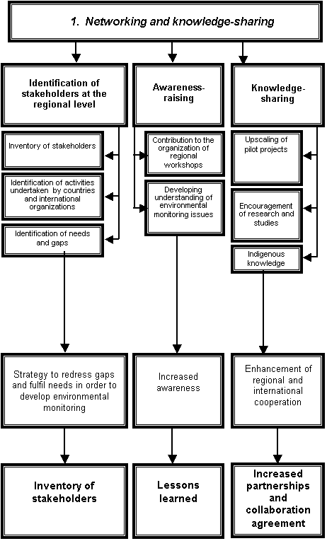
4. At present, space-based observations are
an effective and reliable tool for environmental monitoring. Although their
potential uses are being discovered daily, there are still many unexplored
applications still to be found. Space-based monitoring requires the use of
space platforms with appropriate sensors on board.
5. Managing data and setting up databases
with acquired monitoring data constitute the next component of the
environmental monitoring system. The availability of data for planners,
decision makers, specialists and scientists on issues related to environmental
monitoring is also essential.
6. Based on the recommendations of UNISPACE
III, the Action Team aims to launch a worldwide strategy for environmental
monitoring that would: (a) ensure the sustainable use of ecosystems; and (b)
promote national, regional and global cooperation on critical environmental
issues. To achieve that aim it is necessary: (a) to know what to monitor
(dynamics of environmental phenomena); (b) to assess and adopt monitoring
techniques; (c) to set up a convenient monitoring system or systems; (d) to
establish guidelines; (e) to build capacity; (f) to enhance partnerships among
relevant national, regional and international institutions; and (g) to involve
non-governmental organizations and the public. It is essential to join existing
efforts in order to promote greater technical cooperation, to enhance knowledge
and experience exchange among countries, to develop policies to achieve
sustainable environmental development and to build upon current development and
national environmental action plans and rural development strategies.
II. Inventory of existing strategies at the
regional and international levels
A. The background to global environmental
monitoring
7. The Action Team noted the following
historical milestones and background in the development of a global
environmental monitoring strategy:
(a) The
early 1960s:
(i)
National strategies for global monitoring;
(ii) Broad international cooperation on
meteorology and weather forecasting;
(b) The
United Nations Conference on the Human Environment, held in Stockholm in 1972:
(i) International
definition of monitoring;
(ii) Establishment
of the United Nations Environment Programme (UNEP);
(c) The
United Nations Conference on Environment and Development, held in Rio de
Janeiro, Brazil, in 1992:
(i) Agenda
21;[4]
(ii) Establishment
of the Commission on Sustainable Development;
(d)
UNISPACE III, held in Vienna in 1999:
Recommendations
contained in the Vienna Declaration and other recommendations;
(e) The
Millennium Summit of the United Nations, held in New York in 2000;
(f) the
World Summit on Sustainable Development, held in Johannesburg, South Africa, in
2002.
B. Existing strategies
8. An indicative list of existing
strategies on environmental monitoring identified by the Action Team is
provided below:
(a) Global
strategies of international entities:
(i) Organizations of the United Nations
system such as UNEP, the International Oceanographic Commission of the United
Nations Educational, Scientific and Cultural Organization (UNESCO/IOC), the
Food and Agriculture Organization of the United Nations (FAO) and the World
Meteorological Organization (WMO):
a. United Nations System-wide Earth-Watch;
b. Environmental Observing and Assessment Strategy (UNEP);
c. Information, Monitoring and Assessment Strategy (FAO);
d. Global Climate Observing System (GCOS),
Global Terrestrial Observing System (GTOS) and Global Ocean Observing System
(GOOS);
(ii) International
process on sustainable development;
(iii) Integrated Global Observing Strategy (IGOS)
Partnership (Committee on Earth Observation Satellites (CEOS));
(iv) Global Monitoring for Environment and
Security (GMES). (European Space Agency and the European Commission);
(b) Global
monitoring efforts at the national level pursued by:
(i) China,
India and Japan;
(ii) The
Russian Federation:
a. Russian Aviation and Space Agency (Rosaviakosmos);
b. Russian Federal Service for
Hydrometeorology and Environment Monitoring (Roshydromet);
(iii) The
United States of America:
a. Mission to Planet Earth of the National
Aeronautics and Space Administration (NASA);
b. National Oceanic and Atmospheric Administration (NOAA);
(iv) Other
regional, local or thematic programmes.
9. A brief review of existing strategies at
the international and regional levels will be provided in a full report of the
Action Team.
C. Conclusions
10. The full inventory of existing strategies
should include:
(a) A
comparative analysis, to identify common features, divergences, gaps and best
practices identified in the various strategies;
(b) Definition
of the key elements for purposes of policy formulation: the elements to be
defined include “global”, “comprehensive”, “integrated”, and “supporting
sustainable development”;
(c) Development
of a strategy model, including recommendations, a review of compiled
information and a preliminary implementation plan.
11. To achieve the objectives of an
environmental monitoring strategy and to develop an implementation plan, needs
and requirements should already be defined, taking into account the following:
(a) the dynamics of the rapidly changing environmental, socio-economic and
information landscape; (b) scientific and technical development; (c)
shortcomings in data and information; (d) gaps in technology and instruments;
and (e) increasing the number of cross-cutting issues and linkages.
12. There should also be a variety of sources
and mechanisms for collaboration that provide broad experience in planning and
implementation, a wide range of strategies and operational process and
different approaches and multi-level studies.
III. Applications of space technology for
environmental monitoring with the combined use of other ancillary techniques
A. Integration of the ground segment and ground
truth
13. Data are produced by ground- and
space-based monitoring networks and statistical surveys carried out by
national, regional and international organizations. The use of satellite data
for environmental reporting has increased, but its full potential remains
untapped. The commonly held view that space observations would make ground-based
measurements redundant is seldom justified. While space observations may reduce
the need for conventional in situ measurements, they do not eliminate the need
for direct reporting and ground truthing.
14. The emphasis has already shifted from
problems associated with obtaining or gaining information to those associated
with effective use of the information and providing users with information in a
user-friendly form. For various environmental systems, satellite systems of
online monitoring of the Earth are the main source for developing a monitoring
information base. A broad range of information obtained from various satellites
in the form of images of the Earth in different spectral ranges and spatial
resolutions is accumulated in many countries. The Russian Federation, in
particular, has formed an enormous archive of low-, medium- and high-resolution
data as well as databases of topographic and geodetic information.
Nevertheless, it is predicted that, by the year 2010, meeting the requirements
of different regions of the world for new maps will become the main problem for
global mapping. Mapping of large territories has been carried out for many
years and cartographic materials have been in need of updating for a long time.
This need will increase.
15. Moreover, because of the increasing need
for data of the Earth for sustainable development of the environment and
available natural resources, greater attention should be paid to monitoring
indicators of sustainability, including: (a) vegetation degradation (as in
clearing for agriculture); (b) forest disturbance; (c) biodiversity; (d)
changes in land cover; (e) estimation of agricultural crops; (f) the condition
and erosion of the soil; (g) quality of inland waters and the condition of
coastal wetlands; (h) the potential for landslides; drought stress on natural
resources; (j) local, regional and global changes in surface temperature;
and (k) disaster management. These indicators have three important features:
(a) remote sensing can provide reliable measurements on a regular basis; (b)
measurements can be reproduced without bias; and (c) the indicators truly
reflect the characteristics of the changing environment.
B. Data quality and availability[5]
16. Lack of relevant data is a common
experience. In the environmental domain, there are still serious data gaps
related to, for example, pesticide application, the state of fish stocks,
forest quality, groundwater and biological diversity. The quality of the
existing data is of equal concern and the causes of data gaps and poor data
quality are complex and diverse.
17. There are inherent challenges in working
with data sets on a global scale. From the perspective of global Earth
observation (GEO) as a high-level global assessment, linkages of data across
scales are particularly important. Considering that, in general, only data with
the same resolution, standards and date of measurement can be reliably
aggregated to a regional or global level, even small discrepancies or gaps can
make data sets incomplete or deficient. At the same time, even with
good-quality data, aggregation and averaging may mask important spatial or
temporal detail. In large-scale aggregations, features unique to smaller
regions disappear. Therefore, the scale of aggregation and reporting of averages
should be carefully matched with the scale of environmental phenomena or
policies and the purpose of assessment.
18. Most of the available data apply to
quantitative attributes of the environment. While measuring qualitative
variables is usually more difficult, it is often through qualitative change
that major trends can be detected. Monitoring the quality of the ecosystem, for
example, for forests or fisheries, needs to be improved.
19. Some new global or regional compendiums of
environment-related data have considerably improved the global stock of data
resources. Notable examples are the Dobris data compilations in Europe and the
World Bank's World Development Indicators. In addition, a small but
steadily growing number of countries have set up systematic compilations of
environmental data, in part following the guidelines of the Statistics Division
of the Secretariat. This is resulting in national environmental reports being
issued by more countries and in the gradual improvement and harmonization of
reporting to the Commission on Sustainable Development and within the framework
of multilateral environmental agreements. The relatively widespread testing of
the Commission’s indicator methodology by countries may well lead to demand for
developing more concrete input data.
20. As regards needs for geo-referenced data
in environmental assessment, there is a gradual recognition of the need to use
geo-referenced data in environmental assessment and the need to have some
information broken down by spatial units other than administrative units. Some
important global geo-referenced data sets, such as population and landcover,
have been produced in the past few years. However, this should be considered
only as the beginning. Few, if any, of the new data sets seem to be routinely
updated.
21. As for data access, data may be
inaccessible because of copyright issues, high cost or professional or
organizational competition. Although some parameters are accurately and
routinely measured, the information may be classified or publicly unavailable.
Difficulty of access to data on shared aquifers and surface water is an example
that is seen in many parts of the world.
22. However, public and institutional
attitudes towards access to data have changed noticeably during the past
decade. With the widespread access to the Internet, the decrease in both cost
and difficulty of mass data processing and the fact that there is no longer a
need for cold war-style security measures, the public has become more demanding
and institutions more proactive and open. This is true for a wide range of
issues involving many organizations. The most symbolic event that serves as an
example is the partial declassification of military satellite imagery.
23. The opening up of data holdings and data
exchange leads to two potential problems for their use in broad assessments
such as the Global Environment Outlook reports by UNEP. Firstly, access
to essential data, which is currently taken for granted, may become more
commercialized and therefore more difficult for multilateral organizations and
other users who are conducting environment assessment. In particular, this
applies to satellite data and to large integrated databases. Secondly, as data
become more widely distributed and recycled, critical validation will become
even more important than it is at present, making sound scientific links
essential for assessments of the UNEP type.
C. Centre for obtaining, receiving and
processing information
24. It is possible to avoid deficiency of
information by establishing regional Earth monitoring centres utilizing modern
technologies for receiving and processing satellite, aerial and in situ data.
These technologies should allow for automated machine interpretation of the
results of imaging, synthesis of thematic maps for complex analysis of
territories, development of local or regional geographical information systems
(GIS), generation of information from data and support to decision and
policy-making processes. Prospective information technologies for monitoring
are related to the development of such dedicated regional information systems
for specific purposes. Based on those systems, it would be possible to maintain
effective land and water cadastral surveys to manage resources and to carry
out, for example, ecological tasks, regional land use tasks and thematic
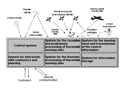
mapping tasks. A possible structure for a proposed regional centre for
monitoring of the Earth is shown in the figure. A more detailed description of
the geo-information centre will be presented in the full report of the Action
Team.
 Figure
Geo-information centre
25. The closer integration of remote sensing
and GIS is increasingly becoming the dominant tendency in modern development.
As a final result, it is quite possible to obtain a merger of remote sensing
and GIS into a joint processing and information distribution system. In such a
case, the capacity of such a joint system will be larger than the sum of the
capacities of the individual systems involved. The companies working in the
fields of remote sensing and GIS are becoming more and more information
companies.
26. The geo-information centre presented in
the figure would allow for production and maintenance of an economically and
technically efficient dynamic GIS, making it possible to conduct regular
analyses of observations of the ground, adding data to a remote sensing
database and updating the information system at all levels.
D. Next steps for the development of the ground
segment
27. To improve data availability for
environmental assessment, the Global Environment Outlook 2000 recommends
the following for immediate action:
(a) Complete
analysis of information, focusing on priority environmental issues and
including underlying causes as well as the impact on humans and on nature;
(b) Development
of a set of objective data sets on driving forces behind environmental
monitoring and pressures on the environment at the regional level, building
upon work conducted by the Global Resource Information Database (GRID), the National
Institute of Public Health and the Environment (RIVM) of the Netherlands and
the World Resource Institute among others;
(c) Further
strengthening of coordination with monitoring programmes, taking into account
needs from the perspective of integrated assessment of environment and
sustainability issues;
(d) Improvement
in access to indicators and underlying data for collaborating centres through a
dedicated Intranet platform based on the Global Environment Outlook 2000,
the public Internet and CD-ROM;
(e) Strengthening
the participatory approach and the status of data through capacity-building at
regional centres for integrated environmental assessment and data validation
and feedback;
(f) More
stress should be placed on institutional and political aspects of observation
and to the translation of data into information: a better understanding would
lay the foundations for long-term improvement of the data situation.
1. From data to information: modelling and
prediction
28. The results of regional efforts should be
used to refine global narratives and to undertake the subsequent quantitative
analyses associated with scenario narratives. Further refinement of both
narratives and quantitative analyses can be achieved through an iterative
process involving the core scenario team and the modelling groups.
2. Need for quantitative analytical tools
29. A few important examples from Global
Environment Outlook 3 will be provided in the full report of the Action
Team.
E. Conclusion
30. The main trend in development is the
integration of technology, involving the following:
(a) Acquisition
of data, including from satellites and airborne remote sensing, and in situ
data;
(b) The
Global Positioning System (GPS) and the Global Navigation Satellite System
(GLONASS);
(c) Data
processing, including software and hardware;
(d) Integration
of data into GIS and other information systems;
(e) Cost
effectiveness and the prices of technology and services;
(f) User
education and training.
31. The geo-information centre proposed above
would provide a comprehensive and economically effective structure for the
organization of work in receiving, processing and distributing data for
environmental monitoring purposes. It would bring together modern
infrastructure for receiving, processing and distributing data and deriving
information. The geo-information centre would include satellite, aerial and
ground-based technology for data collection and processing, GPS/GLONASS
equipment, communication equipment, hardware and software for data processing
and integration into GIS and other information systems. Moreover, the
development of technology and the market indicates that the use of remote
sensing technologies is most effective in the case of combined use of different
kinds of information, database and information-processing technology.
32. The use of the geo-information centre
would provide opportunities for filling the knowledge gaps in the following
areas: (a) transformation of environmental data into information; (b) policy
implementation; and (c) funding and finance.
33. It would also present opportunities for
taking an integrated and comprehensive approach to mainstream thinking,
integrated management, international coordination and technology development.
This approach would provide: (a) comprehensive quantitative tools; (b)
scientific and institutional technical and mathematic models; and (c)
decision-support tools as the linkage between scientists or technicians and
policy makers.
IV.
Examples of space applications in land,
water and air environments
34. The unique ability of remote sensing
satellites to provide comprehensive, synoptic and multi-temporal coverage of
large areas at regular intervals is an example of a space technology
application for environmental monitoring. Remote sensing satellites have been
and will remain an indispensable tool for continuous monitoring of dust storms,
desertification, forest fires, floods, oil spills, volcanic eruptions and
depletion of the ozone.
A. Air pollution and dust storms
35. Dust and smoke, or aerosols, are tiny
particles caught in the air. Some occur naturally, originating from volcanoes,
dust storms, forest and grassland fires, live vegetation and sea spray. Human
activities, such as burning of fossil fuels and alternation of natural surface
cover, also generate aerosols. Many human-produced aerosols are small enough to
be inhaled, posing a serious health hazard around industrial centres and even
over hundreds of miles downwind. Thick dust or smoke plumes severely limit
visibility and can make it hazardous to travel by air or road. Recent research
indicates that aerosol pollution can modify cloud properties and thus reduce or
prevent precipitation in the polluted region, while aerosols containing black
carbon can have an impact on climate and inhibit formation of clouds.
B. Desertification monitoring
36. The United Nations Convention to Combat
Desertification in those Countries Experiencing Serious Drought and/or
Desertification, particularly in Africa,[6] indicates that desertification is land
degradation in arid, semi-arid and dry sub-humid areas resulting from various
factors, including climatic variations and human activities. Monitoring of
desertification includes activities that are part of the integrated assessment
and restoration of the degraded land and are aimed at: (a) assessment of
current states of desertification; (b) analysis of land degradation process;
(c) selection of basic indicators of desertification; (d) mapping of degraded
land and other related natural resources; (e) evaluation of the impact of land
use change and implemented rehabilitation measures; and (f) monitoring of
desertification using space technology. Some examples of monitoring of
desertification as well as the recommended methodology to monitor
desertification processes using remote sensing techniques will be provided in
the full report of the Action Team.
C. Forest fires
37. Detection
of forest fires is made possible either by sensing the thermal or mid-infrared
spectral signature of the forests during the day and the night or by detecting
the light emitted by them at night.
Wildfire is a natural part of the Earth’s environment, caused in most
cases by lightning strikes and occasionally by volcanic eruptions. Wildfires
affect a million or more square kilometres (sq km) per year. People also start
many fires, sometimes accidentally, but in most cases deliberately. Fire is
used in agriculture to clear croplands and help return nutrients to the soil.
Prescribed fires clear away dead and dying vegetation to help rejuvenate
forests and reduce the risk of large, uncontrolled wildfires. Fire is also a
tool people use to help clear forests for human usage. Annually, people burn
between 750,000 sq km and 8.2 million sq km of forests and grasslands around
the world.
D. Floods
38. Floods have been an integral part of human
history ever since the start of the agricultural revolution following the first
permanent settlements on the banks of the great rivers of Africa and Asia.
Seasonal floods deliver valuable topsoil and nutrients to farmlands and bring
life to otherwise infertile regions of the world such as the valley of the
Nile. On the other hand, flash floods are responsible for more deaths than
tornadoes or hurricanes. Floods are also responsible for billions of dollars in
property damage every year.
E. Oil spills
39. Oil spills are caused either by break-up
of tankers at sea or by illegal discharge from and clean-up of tankers.
Discharge of oil is the more important of the two causes of oil spillage. Many
countries have signed agreements such as the International Convention for the
Prevention of Pollution from Ships and the United Nations Convention on the Law
of the Sea[7] and other regional agreements that
forbid dumping of waste materials in the marine environment. Earth observation
data are used operationally to monitor oil spills and to enforce compliance
with the agreements by using radar and thermal data provided by Radarsat, the
European Space Agency (ESA) Remote Sensing Satellite (ERS-2), Satellite pour
l’observation de la Terre (SPOT-5) and the Land Remote Sensing Satellite
(LANDSAT)-Thematic Mapper.
F. Volcanic eruptions
40. Volcanic eruptions can be both awesome and
deadly, presenting a major hazard to those who live near them for a variety of
reasons. Pyroclastic eruptions can smother large areas of land with hot ash,
dust and smoke within a span of minutes to hours. Red-hot rocks spewed from the
mouth of a volcano can ignite fires in nearby forests and towns, while rivers
of molten lava can destroy almost anything in their path as they reshape the
landscape. Heavy rains or a rapidly melting snow pack at the summit can trigger
lahars—masses of mud that can flow for miles, burying roads and villages. Large
plumes of ash and gas ejected high into the atmosphere can influence climate,
sometimes on a global scale.
G. Ozone depletion
41. The atmosphere thins as it rises above the
curve of the Earth’s surface. The layer of atmosphere between 10 and 50 km
high, called the “limb”, provides a side view of the structure of the
atmosphere. Orbiting scientific instruments look at the limb to measure how the
concentrations of trace gases vary with altitude and to monitor holes in the
ozone. The Total Ozone Mapping Spectrometer (TOMS) instrument aboard Nimbus-7,
the Global Ozone Monitoring Experiment (GOME) aboard ERS-2 and the Shuttle
Ozone Limb Sounding Experiment–2 (SOLSE-2) on the Space Shuttle Columbia were
used to detect such holes.
V. Guidelines for a comprehensive worldwide
strategy: a model based on education, training and capacity-building
42. As a result of rapid population growth and
climatic changes, environmental systems have been subjected to high pressure to
meet increasing demand for food and other elements necessary for life. That
pressure has resulted in many cases in degradation of the environment. Despite
efforts undertaken to rationalize the use of environmental systems such as land
and water resources, large areas worldwide have been degraded and are now
facing many environmental problems. Both natural factors and human activities,
in particular in fragile and unstable ecosystems, have contributed to the
process of environmental degradation. The result is unbalanced natural
environmental systems. It is, therefore, very important to monitor and assess
the degradation process at its early stages in order to take the necessary
measures to combat it and rehabilitate the degraded systems.
43. In response to that situation, the
international community has given high priority to environmental monitoring, as
evidenced by UNISPACE III, which called for action to develop a comprehensive,
worldwide, environmental monitoring strategy in the Vienna Declaration.
44. The main objective of the work plan
proposed in the present report is to launch a space-based worldwide strategy
for environmental monitoring, ensuring the sustainable use of ecosystems and
promoting regional cooperation on critical environmental issues. More specific
objectives include the following:
(a) Implementation
of a preoperational system to monitor the dynamics of certain environmental
phenomena in selected areas;
(b) Assessment
and adaptation of relevant techniques for environmental monitoring;
(c) Provision
of guidelines for effective implementation of environmental monitoring;
(d) Provision
of support for capacity-building of local staff in environmental monitoring, in
cooperation with concerned national institutions;
(e) Enhancement
of partnerships between relevant national, regional and international
institutions;
(f) Provision
of support for the involvement of non-governmental organizations and the local
population in environmental monitoring.
45. To achieve the above-mentioned objectives,
the work plan should concentrate resources and efforts on achieving greater
technical cooperation, enhancing the exchange of good practices among countries
and encouraging the development of policies leading to sustainable
environmental development. The work plan should build upon existing development
plans, national environmental action plans and rural development strategies. A
graphic representation of the work plan is provided in annex I.
A. Technical components
46. The work plan consists of four technical
components. Each component consists of a set of outputs, which will be
delivered through specific activities.
Technical component 1. Networking and
knowledge-sharing
47. This component includes the exchange of
information on best practices on environmental monitoring among countries at
the regional level. In that domain, the work plan will rely on a regional
consultative approach for the collection and distribution of related
information. Awareness-raising and training workshops will be essential to
bridge knowledge gaps between countries and will take into account the work in
the area accomplished by organizations or networks.
48. Three outputs are expected:
(a) Output
1. Identification of stakeholders at the regional level
(i) Activities:
a. Compilation of an inventory of all
stakeholders working on environmental monitoring at the regional level;
b. Identification and documentation of
activities undertaken by countries and international institutions in the field
of environmental monitoring;
c. Identification of needs and gaps as
regards issues related to environmental monitoring;
(ii) Expected
results:
a. Preparation of a document identifying a
strategy on how to redress gaps and fulfil needs in order to develop or
strengthen space-based environmental monitoring and the role of regional and
international organizations and networks to meet those needs;
b. Compilation of an inventory of all
stakeholders working on environmental monitoring;
(b)
Output 2. Awareness-raising
(i) Activities:
a. Contribution to the organization of regional
workshops in cooperation with specialized bodies and networks;
b. Organization of regional
awareness-raising activities to deepen the understanding of the value of
environmental monitoring;
(ii) Expected
results:
a. Increased awareness among countries of
the linkages between ecosystems and other sectors;
b. More case studies and lessons learned;
(c) Output
3. Knowledge-sharing
(i)
Activities:
a. Upgrading of pilot projects to the
regional level; encouragement of the design, implementation and repetition of
pilot projects at the regional level based on lessons learned;
b. Encouragement of case studies on the
development of natural resource management techniques;
c. Dissemination of guidelines and best
practices among countries on the use of indigenous techniques to monitor,
protect and enhance ecosystems;
(ii) Expected
results:
a. Enhanced regional and international
cooperation on a variety of environmental issues through the exchange of
experience and best practices;
b. An increased number of partnerships and
collaboration agreements among concerned institutions at the regional and
international levels.
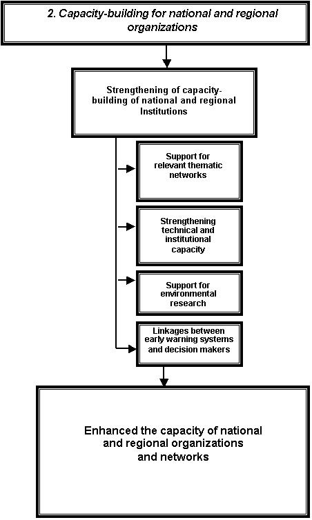
Technical component 2. Capacity-building for
national and regional organizations
49. This component aims at promoting regional cooperation
among countries to strengthen the institutional capacity of national and
regional organizations to promote the exchange of best practices and knowledge
within and among countries.
50. Three outputs are expected:
(a) Output
1. Strengthening of capacity-building of national and regional institutions
(i)
Activities:
a. Strengthening the institutional and
technical capacity of national and regional specialized centres to provide
training in the field of environmental monitoring;
b. Technical support for relevant thematic networks;
c. Support for national and regional environmental research;
d. Strengthening the institutional
relationship and linkages between early warning systems and decision makers to
facilitate timely and appropriate responses to environmental problems;
(ii) Expected
results:
Enhanced
institutional and technical capacity of national and regional organizations and
networks to conduct environmental monitoring and to provide adequate training
and information in that area.
Technical
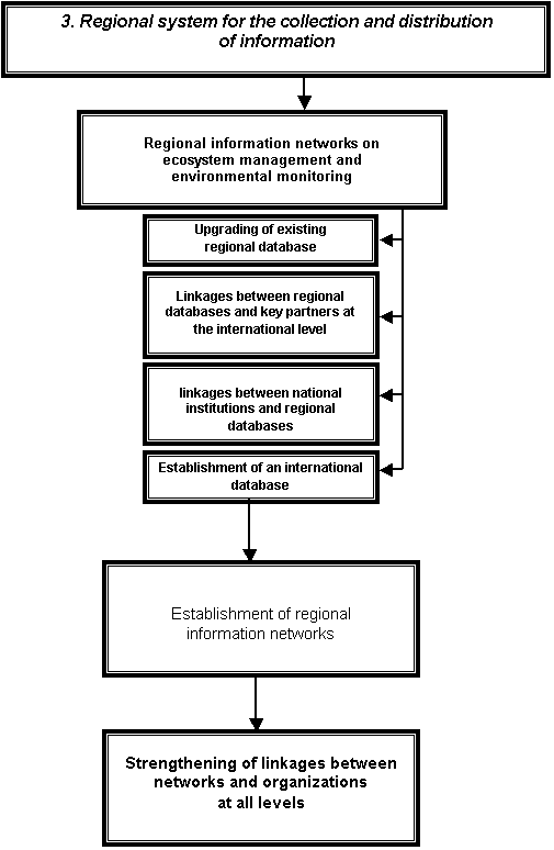
component 3. Regional system for the collection and distribution of information
51. Comprehensive regional information
networks on environmental monitoring need to be established in order to ensure
effective dissemination of information.
52. One output is expected:
(a) Output.
Regional information networks on ecosystem management and environmental
monitoring
(i) Activities:
a. Upgrading of existing regional databases
on environmental monitoring and management in order to create a comprehensive
regional database;
b. Facilitation of linkages among regional
databases in collaboration with key partners at the international level;
c. Encouragement of linkages between the
national institutions and the regional database web sites and thematic
networks;
d. Establishment of an international
database on environmental monitoring;
(ii) Expected
results:
a. Establishment of comprehensive regional
information networks on environmental monitoring and ecosystem management;
b. Strengthening of information and
communication linkages between networks and organizations at all levels.
Technical
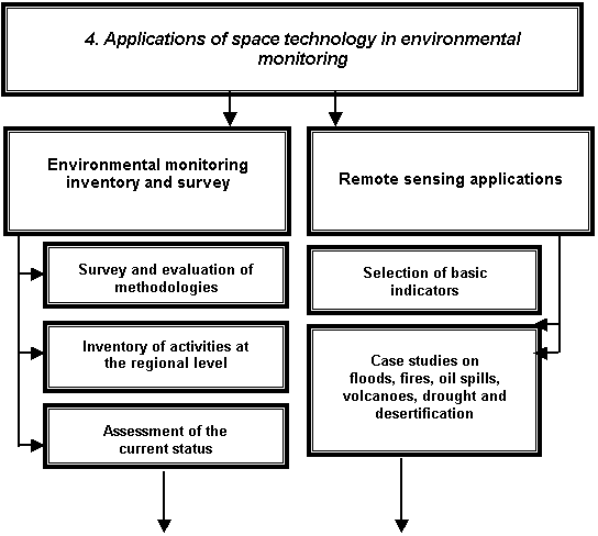
component 4. Space technology applications in environmental monitoring
53. This component will provide the technical
skeleton of the work plan and will be based on selection of monitoring areas
and series of test sites for implementation and assessment of monitoring
techniques with the use of space technology.
54. Two outputs are expected:
(a) Output 1. Environmental monitoring
inventory and survey
(i) Activities:
a. Survey and evaluation of methodologies
used for environmental monitoring;
b. Inventory of environmental monitoring
activities at the regional level;
c. Assessment of the current status of
environmental monitoring at the regional level;
(ii) Expected
results:
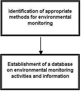
a. Identification of appropriate methods
for environmental monitoring;
b. Establishment of a database on
environmental monitoring activities and information;
(b) Output
2. Remote sensing applications
(i) Activities:
a. Selection of basic indicators of
environmental conditions to be derived from remotely sensed data;
b. Cease studies on levels and types of
environmental monitoring, including the following: (i) definition of data to be
acquired (parameters and measurement protocols); (ii) data acquisition,
including remotely sensed data and ground data sets; (iii) data processing and
analysis using the available hardware and software; (iv) analysis of
environmental degradation causes; and (v) mapping of environmental degradation
trends and highlighting of hot spots;
(ii) Expected
results:
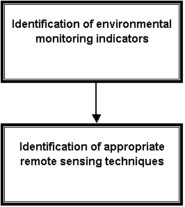
a. Identification of environmental
indicators that can be monitored with the use of remote sensing;
b. Production of environmental maps using
remote sensing and other related space technology;
c. Identification of appropriate remote
sensing techniques and other related space technology for environmental
monitoring and environment degradation assessment.
B. General recommendations
55. The most effective organizational solution
for the continuation of reliable integrated, comprehensive environmental
monitoring is to develop an institutional mechanism, consisting of
interdisciplinary activities with scientific, technical, economic, political
and legal aspects, that is constantly active on a global scale in the interests
of environment protection and for the benefit of all countries. This should
gradually evolve towards the establishment of a united environmental monitoring
system. The following key features should be taken into account in establishing
the monitoring system:
(a) The
system must be globally acceptable, with as many participating countries as
possible, and it should be as comprehensive as possible and integrated at the
horizontal and vertical levels;
(b) The
system must be supported by subsystems for data collection, which should be
well-structured at the national, regional and global levels and coordinated
with socio-economic information systems;
(c) The
system must contain effective tools for data analysis and processing to produce
information and to generate knowledge accessible for officials and the general
public;
(d) The
system must be well-known to policy and decision makers by being able to
present data and information in easily understandable format.
56. In order to create such a system, it is
necessary to develop international legal documents that determine
organizational and technical aspects of the system’s functionality. The first
step could be a resolution of the General Assembly that defines the status of the
monitoring system. Further, an agreement among countries must be signed that
would set forth the rights and obligations of participating countries and the
organizational structure of the system. Technical issues concerning the
operation of the system should also be covered. The whole set of such legal
documents could be developed in stages pending the commitments to be made by
participating countries at the political and legal levels and progress at the
technical level.
57. The implementation of the monitoring
system under the aegis of the United Nations would have the following positive
features for all participants:
(a) Existence
of a unique scientific database on the Earth that conforms to unified
standards;
(b) Closer
cooperation among countries, including cooperation in scientific data exchange
to stimulate investment in data exchange;
(c) Creation
of an infrastructure for information development for society;
(d) Facilitation
of user access to information on global observation;
(e) Improvement
in the quality of information (broader coverage and more frequent updates);
(f) Availability
of different types of observation technology.
58. The monitoring system must be established
and implemented in accordance with international law, including environmental
law, international space law and the laws of international organizations,
bearing in mind the key milestones and their results (see para. 10 above) that
would provide the basis for environmental law.
59. The process of establishing the monitoring
system must be gradual. Integration procedures should be accomplished taking
into account existing international acquisition systems and use of Earth
observation data. At the initial stages, existing monitoring facilities must be
identified for integration into the monitoring system. At a later stage, the
management of the system would determine what further types of observation
device would be required for the effective functioning of the System and which
countries should participate in what manner. Distribution of the work involved
must be determined on a voluntary basis and taking into account the national
interests of participating countries.
60. The objectives to be achieved for the
project to develop the monitoring system could be as follows:
Year 2004
(a)
Development and establishment by participating countries of legal
organizational documents defining the status of the monitoring system, the
rights and responsibilities of countries participating in the project, the role
and functions of international authorities and conditions of access to
information;
(b) February.
Development of a document determining the tasks and purposes of the monitoring
system and its coordination with participating countries;
(c) Inventory
of existing monitoring facilities that could be provided by participating
countries to meet the needs of the system;
(d) Development
and coordination of standards, formats, classifiers and data-processing methods
required for the system;
(e) Development
of technical proposals for the system;
Year 2005
(a) Establishment
of authorities to coordinate the work involved;
(b) Development,
within the framework of the system, of centres for collection, processing and
preparation of information for end users;
2005-2008
Integration of national observation
systems;
2008-2010
Development of new technologies in
order to expand the capacity of the system;
2011-2012
Upgrading of the system to become
fully operational.
61. In the early stages of the establishment
of the monitoring system, a strategy for integrated, comprehensive
environmental monitoring could be implemented through pilot projects, which
would allow local communities to take practical steps as well as to test and
practice the main technological approaches and basic ideas. Two pilot projects
are proposed:
(a) Remote
sensing applications for monitoring of desertification (see annex II);
(b) Establishment
of an institute (cycle of workshops and training activities) on the use of
integrated comprehensive data for environmental monitoring (see
annex III).
62. In the process of implementing the
strategy for integrated, comprehensive environmental monitoring, other pilot
projects suggested by relevant action teams established by the Committee on the
Peaceful Uses of Outer Space to implement recommendations of UNISPACE III could
also be implemented.