Welcome
to the Parks and Playgrounds Movement Inc. Website.
Celebrating 50 Years of Environmental Action
Celebrating 50 Years of Environmental Action
| |
Welcome
to the Parks and Playgrounds Movement Inc. Website. Celebrating 50 Years of Environmental Action |
| ISSUES INDEX | ANNUAL REPORTS | LINKS | Sign Guestbook | View Guestbook |
|
Public Meeting Tuesday, 1 May 2001 Green Point Foreshore Reserve - Proposed Extension Cycle Path to Dilkera Ave
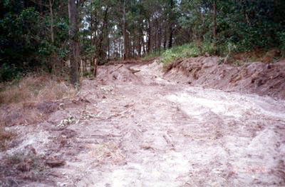
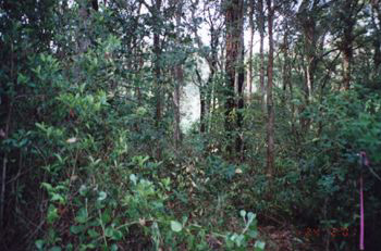
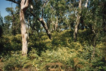
The proposal to build a 2.5 metre wide cycle path through bushland at the northern end of Green Point Foreshore Reserve from Dilkera Ave will impact on the high quality bushland of the Reserve and will not satisfy the needs of the reserve and is contrary to the core values of the Foreshore Reserve. To ensure the ongoing ecological viability of the land by protecting the ecological Biodiversity and habitat values of the land, the flora and fauna (including invertebrates, fungi and micro organisms) of the land and other ecological values of the land and To protect the aesthetic, heritage, recreational and scientific values of the land, and To promote the management of the land in a manner that protects and enhances the values and quality of the land and facilitates the enjoyment of the land, and to implement measures directed to minimise or mitigate any disturbance caused by human intrusion and To restore degraded bushland, and To protect bushland as a natural stabiliser of the soil surface. To protect existing landforms such as natural drainage lines, watercourses and foreshores, and To retain bushland in parcels of a size and configuration that will enable the existing plant and animal communities to survive in the long term, and See LMCC Plan of Management Green Point Foreshore Reserve (POM) EDAW The regional off road cycle path has been completed through the reserve from Green Point Drive (The main Entrance) to Ross Street providing a circuit connecting Sea Eagle Lookout and Picnic Area and the Ross St. entrance. The circuit directly connects to the official 1997 Regional Bike Plan Route on Croudace Bay Rd.. The proposed cycle path extension to Dilkera Ave would effect the identified littoral rainforest, the rain forest regeneration area and pass through the Backhousia forest. In will impact on a Squirrel Glider habitat and disturb rare ground orchids. It is in an area that should only be accessed by narrow nature trails. The Cycle path as planned will cause devastation during construction and fragmentation of the remaining high conservation bushland and the steep slopes. This is a high quality bushland part of the reserve. The sensitive bushland in this area and the rare fauna is partly acknowledged by the proposal to build three bridges and expend a million dollars.
However the basic justification and impact of the 2.5 metre wide cycle path has not been considered. The expenditure is difficult to justify given that there is a real and pressing need for parking and picnic facilities at the main entrance to serve the increasing number of people visiting the reserve. The cycleway route in the adopted plan is a shared fire trail designed to give fire trucks access. The proposed cycleway expenditure will not serve the reserve or make an improvement to the interpretation of the reserve. The need for an attractive main entrance gateway at Green Pt. Drive, (car parking, landscaping and regional picnic facilities) is not satisfied by this suggested change of the plan.
Furthermore a long bridge at a grade would be dangerous for pedestrians and cyclists and will need massive foundations which may be difficult to obtain because of mine subsidence in this area. Parks and Playgrounds Movement wants priority given to parking and picnic facilities at the main entrance and a sensitive walking trail at the Dilkera end of the park as required by the POM. Doug Lithgow
Parks and Playgrounds Movement Inc.
Tuesday, 1 May 2001 40 YEAR CAMPAIGN FOR GREEN POINT FORESHORE RESERVE Lake Macquarie NSW Cardiff Coal Coy Land identified for National Park 1956. (Cardiff Coal Coy was dormant since the thirties) The land owned by the Cardiff Coal Company, Portions 35A and 36A together with the adjacent Portions 37A and 38A had been identified for a 'County National Park' in 1956 by the Lake Macquarie Shire Council and by the Northumberland County Council. Planning Authority 1948/63. There has been continuous community support for the park over more than 40 years lead by the Northern Parks and Playgrounds Movement (Oct.1988, Green Point Action Committee set up) Newcastle Herald carried a story 3/11/1984 describing a proposal to develop a $100 million dollar housing marina hotel and leisure facility over the four portions at Green Point. Because of the long standing National Park proposal over the land the Parks and Playgrounds Movement called for the preparation of a Local Environmental Study before any rezoning was to be considered by the Lake Macquarie Council. A number of studies were ultimately completed. NSW Government's Green Point Task Force 20th April 1990 supported the park proposal with subdivision of the quarry. In 1989 the heirs of James Lunn, an original promoter and share holder of the Cardiff Coal Company, began action in the NSW Supreme Court (3047/89) to have their share holding in the Cardiff Coal Coy reinstated. It was alleged that their Cardiff Coal Coy. shares were transfered to Belmont Colliery P/L who had a lease over part Por.36A. There were no valid share transfer. His Honour, Justice Hulme in his Reasons for Judgment (Lunn V Savage) dated 14th Oct.1994 found that documents transferring share holding to Belmont were forged either in 1938 or 1976 and in his Judgment of 6th Sep.1996 his Honour made orders: (i) that the Lunn share holding be restored to the share register, (ii) that a Receiver be appointed to the company and (iii)that there be an account of the dealings of the Cardiff Coal Coy. An appeal was heard before Handley JA Sheller JA and Sheppard AJA on the 8th to the17th of September 1997. Counsel for Lunn, F.S. McAlary QC and Counsel for Savage, I.D.F. Callinan QC. The appeal was dismissed 9th of March 1998. Further leave to appeal dismissed by High Court. The Cardiff Coal land (Por.35A & 36A) was sold in 1992 to McCloys Pty Ltd a developer despite the litigation. There was continuing and widespread concern in the community and the Lake Macquarie Council resolved to acquired 154 ha.of the land for the creation of the Green Pt Foreshore Reserve. The remaining 66 ha. was to be rezoned for housing in accordance with a Deed of Agreement between McCloys and the Council dated 19/7/94. The 154 ha. Green Point Foreshore Bushland Reserve has at last been created on the shores of Lake Macquarie albeit with a number of finger subdivisions projecting into the reserve and at a cost of about $4.5 million dollars. A further $1.5 million for a management plan, weed eradication and park development was granted by the NSW Government. Management Challenge -* protect the bushland reserve *develop main entrance car park and picnic grounds at Green Point Drive. ---------------------------------------------------------------- Back to Issues Index |