Welcome
to the Parks and Playgrounds Movement Inc. Website.
Celebrating 50 Years of Environmental Action
Celebrating 50 Years of Environmental Action
| |
Welcome
to the Parks and Playgrounds Movement Inc. Website. Celebrating 50 Years of Environmental Action |
| ISSUES INDEX | ANNUAL REPORTS | LINKS | Sign Guestbook | View Guestbook |
|
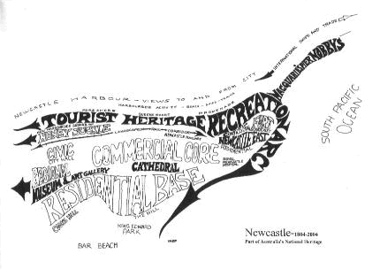
NEWCASTLE
FORESHORE LANDSCAPE : AN OVERVIEW
BACKGROUND The Parks and Playgrounds Movement has had a long interest in the Newcastle Harbour Foreshore and an association with those citizens who have been working for the improvement of the amenity of this part of the city over many years. Our work in the public interest on the foreshore and Newcastle East over thirty years has involved members in countless hours of research, attendance at meetings, field inspections, study of plans and preparation of submissions. During this time our members have accumulated a storehouse of knowledge and understanding of the special problems of the area. The planning structure of the foreshore and its significance should be recognised as it is impossible to ensure the creation of a fine setting for the city that relates directly to its history and natural growth pattern unless this is clearly understood.
LONG TERM PLANNING STRUCTURE The two most important elements in the long term planning structure that should be identified are the rail and road transport spine and the historic tourist recreation arc. The rail corridor and the transport spine The historic Newcastle Town was formally established by 1828 between Brown Street in the west and Pacific Street in the east. The Australian Agricultural Company lands were to the west of Brown Street and Government Reserved lands to the east of Pacific Street. The Cathedral was to be on the hill overlooking the town with an axis to the waterfront through the Cathedral Burial Ground and Market Square. The Newcastle township was later flanked with a rail corridor to Newcastle Station. This corridor is part of the transport spine that is a distinctive characteristic of the City of Newcastle today. The existing passenger rail link to Newcastle Station provides spare capacity for access to the historic tourist recreation arc that is unparalleled in any other Australian city. The Harbourfront and Newcastle's History (Historic Tourist Recreation Arc) Newcastle's history and its harbourfront are intricately interwoven from its long Aboriginal past through to the convict settlement and later industrialisation. This fascinating history is in evidence within the broad structural arc that encompasses the Harbourfront; Nobbys, the convict built breakwater, the ocean beaches, Fort Scratchley, the old bond stores, remnant sand dunes, the convict stockade, the former railway marshalling yards, ballast wharves and rail corridor. This uniquely historic arc is backed by the city core and is destined to become a tourist and recreation destination of great significance in Australia. The elements of the original city core should be seen as part of a comprehensive whole and all landscape and public park development should enhance, reveal or develop the historic city structure. The passenger rail corridor and the harbourfront tourist and recreation arc are essential features of that structure and could become a focus for Newcastle's revitalisation in the future. The Newcastle Harbour Foreshore with its landscape is the unifying and connecting element but the city has not yet extended these landscape links because individual issues are often considered without the comprehensive overview that is necessary.
THE NEWCASTLE HARBOUR FORESHORE SCHEME
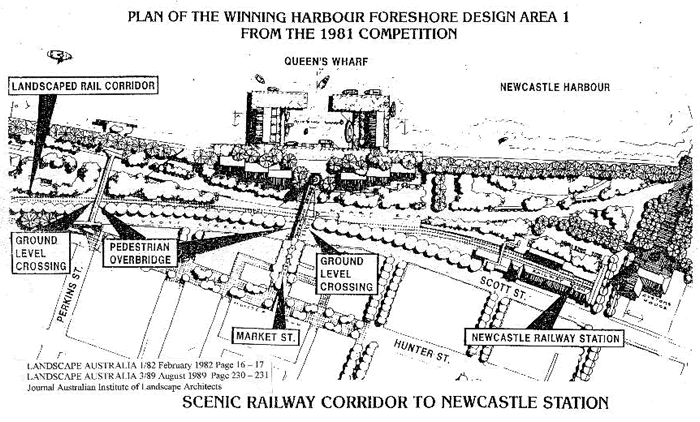
The Newcastle Harbour Foreshore Competition In September 1979 the Newcastle City Council resolved to hold a major international design competition for the Newcastle harbour foreshore and the Lord Mayor Ald. Joy Cummings A.M. noted in the preamble to the competition in 1981 that few cities in the world would have the opportunity to put forward such a scheme. Because this area has remained in Government ownership, we still have the opportunity to develop what I see as the most exciting development for Newcastle in this century. This was not the first time that the City Council had tried to seek the release of the old marshalling yards at Newcastle East for public parklands but it was significant in that a unified approach was being made for a landscape and urban design project. The winning design from the competition was brilliant in its simplicity and scope. It was firmly based on an understanding of the morphology of the city and provided the impetus for a revaluation of the image of the city. The funding and implementation of a large portion of the project was carried out as part of Newcastle's highly successful contribution to Australia's 1988 bicentennial celebrations.
IMPORTANT DESIGN FEATURES Features of the winning entry included the realignment of Wharf Road, the reopening of the Watt Street through to Wharf Rd. and the rationalisation of the rail corridor for passenger rail. These basic traffic articulation and transport features were to be arranged within an attractive landscape and pedestrian flow pattern which emphasised the integration of city, harbourside and parkland. The landscaped rail corridor was an essential feature of the foreshore design and was fully incorporated into the landscape pattern. The railway easement was to be reduced in width to less than half its present width from Brown Street to Newcastle Station with only two railway tracks operating. The third track which was previously used to connect the old marshalling yards at Newcastle East to the Darks iceworks siding was to be removed. This line is now used for the stabling of trains that could easily be stabled at Honeysuckle or Newcastle Station. The land that was to be released by the rationalisation of the rail easement was to be used in the foreshore design to provide lawns and landscaping and to allow Wharf Road to be aligned in such a way as to reduce the crossing distance at Queens Wharf. The Design also provided for a much needed landscaped parking area and bus standing facility on the northern side of the Newcastle Station for picking up and setting down of rail passengers. Two ramped overbridges were to be provided to connect the Hunter Street Mall directly with the foreshore and Queens Wharf. A pedestrian concourse was designed to flow from the Mall down Market Street across Scott St. and Wharf Rd to the Harbour Foreshore. One other rail crossing was suggested at the Perkins Street end of the Foreshore Scheme. The Harbourfront Promenade connected Newcastle's historic breakwater with a generous civic scale walkway around the harbourside to the old vehicular ferry wharf. This scenic promenade provided a pleasant physical link between the points of interest on the foreshore. Queens Wharf was designed to be linked directly by an overhead gantry type crossing from the Mall with an elevated viewing platform on the original Dangar Axis looking up to the Cathedral and across the harbour. The displayed winning design did not show a marina at Queens Wharf and the buildings were to be of a smaller scale than those which have been built. Landscaping was proposed on the southern or city frontage to Wharf Rd. Shortland Lawn and the proposed amphitheatre on the central axis up to Fort Scratchley were important features of the eastern section of the winning foreshore design. Lawns and landscaping flowed in a generous sward up to the Fort and created a direct physical and visual link with this historic area and vantage point. Nobbys road was to be closed to through traffic and an attractive landscaped buffer was to be planted out to screen the existing residential area from the amphitheatre.
DESIGN CHANGES TO THE WINNING SCHEME Changes to the winning scheme The changes made to the scheme were unfortunate and mainly forced upon the City Council because it had no power over the various statutory bodies that controlled most sections of the site and because the State Government did not pledge itself to the implementation of the full scheme. Newcastle's Lord Mayor Ald Joy Cummings who had been intimately involved with foreshore competition and the winning scheme tragically became very ill and had to stand down. During this vital detail design stage in early 1984 the Newcastle Council was disbanded and an administrator appointed. For these and other reasons the foreshore scheme was then out of the hands of the people of Newcastle and at the mercy of bureaucrats who did not fully understand the potential of the scheme. Shortland Lawn and amphitheatre In 1986 the N.S.W. Housing Commission (now the Department of Housing) went ahead with a proposal to build Commission flats onto the Shortland Lawn. This meant that the amphitheatre had to be reduced in size and pushed out of place toward the end of Nobbys Road. The green buffer between the foreshore and the existing housing had to be abandoned and the closure of Nobbys Rd with its link to Fort Scratchley deleted. There was widespread public concern and disappointment at the dismemberment of this important section of the Foreshore design. The area immediately below the present Fort Scratchley marked almost the exact spot where Lt. John Shortland camped when he visited the Hunter River in September 1797 and discovered the first winnable coal in Australia later mined by convict labour from this location. Queens Wharf Whilst the present Queens Wharf development sits well on the foreshore and is an interesting building complex, its scale is much greater than originally planned and it forms an unrelieved mass on the Wharf Rd. frontage. This is made even worse because Wharf Road was not realigned toward the railway at this point to narrow the railway easement as shown in the winning design. The failure to align the road to comply with the scheme meant that there was insufficient room to landscape the Queens Wharf buildings on the Wharf Rd. frontage. There was strong objection in the community to the first plans made for the buildings which had to be modified to meet some of the public criticism. The present buildings are still particularly ugly when approached from the overhead walkway and the views to the harbour that were to be a feature of the walkway are blocked by the buildings which are twice as high as those shown in the winning design. The Rail Corridor It was a tragedy for the Newcastle Harbour Foreshore Scheme when the N.S.W. Government and the Rail Authorities failed to recognise and support the Scheme. This meant that the City was unable to realise the magnificent benefits of the scenic landscaped rail corridor as a feature in its own right and gain the advantage of the improved crossing facilities and the realignment of the Wharf Road to create extra landscaped areas.
Furthermore the Government and the Railways made no attempt to construct attractive overhead gantries to carry electrical gear when the line was electrified across this sensitive foreshore area. Had the line been electrified with consideration of the importance of the City and the foreshore in mind, simple overhead hoops would have been used for a section of the corridor similar to those used to carry the overhead wires on the Eastern Suburbs railway. If economy was the chief thought however, single stanchions between the two sets of lines with the overhead electrical gear hung from each side could have been used. This would have provided a simple, neat, and practical solution over most of the corridor.
THE LANDSCAPED RAIL CORRIDOR IS STILL THE KEY Notwithstanding the mistakes of the past the rail corridor still remains the key to the foreshore scheme. It has the potential to provide for a huge increase in patronage from other centres and for commuter passengers. It can provide speedy, comfortable access to what will soon become an important tourist and recreational destination. The landscaped rail corridor along the foreshore will enhance the pleasure of arriving at an attractive destination and improve the foreshore landscape. The Newcastle Station itself with the occasional visit of a steam locomotive will be an important attraction capable of drawing thousands of people into the area as on the occasion of the visit of the Flying Scotsman or locomotive 3801. The scenic landscaped railway corridor will give Newcastle an attractive transport spine direct into its heart and historic focus. It can be easily accomplished and must be completed as soon as possible. New and improved rail facilities can also be constructed at Civic in conjuction with the redevelopment of the Honeysuckle area. RELEASE OF FURTHER SRA LAND AT NEWCASTLE EAST Promise to release further land After a long campaign over many years, the State Government in August 1987 released the remaining vacant section of the State Rail Authority land for use as public open space and parkland. The Newcastle City Council resolved to rezone these lands to 6(a) Open Space and Recreation on August 11, 1987 and in May 1989 the Premier of N.S.W.on behalf of the Government vested the lands in Council's control under the Crown Lands Consolidation Act. Tract Consultants were given formal instructions to prepare a draft plan for the inclusion of the additional land into the Harbour Foreshore Park. THE CITIZENS' FORESHORE COMMITTEE The Citizens Foreshore Committee which was established in 1978 and included representatives from eight community groups prepared a plan for the foreshore to show how it could look. This was done in response to a Council engineers plan in 1978 that had only considered traffic. The committee was expressing deep felt concerns of the community and helped create the climate for Council's decision in 1979 to hold an international competition that ultimately led to the harbour foreshore scheme.
TRACT 1989 PLAN UNACCEPTABLE TO THE COMMUNITY The Tract Consultants draft proposals for the 1989 released SRA.land were greeted with deep concern by the Newcastle community because they contained unacceptable proposals for residential buildings on the parkland. It was decided to reconstitute the Citizens' Foreshore Committee and prepare a plan for the landscape of the recently released parkland that incorporated community views. The committee developed a concept and detailed plan for an Historic Park and Open Air Museum to integrate with the existing foreshore park landscape. The plan was launched and widely distributed in May 1989 and won widespread support.
THE HISTORIC PARK AND OPEN AIR MUSEUM The Historic Park and Open Air Museum concept The Historic Park idea dealt only with the site and highlighted the potential for the development of the heritage and recreational values of the land, whilst the concept of the Open Air Museum is a broader theme that creates a wider awareness of Newcastle's unique past its heritage buildings and distinctive landscape. The two concepts are intertwined within the park landscape but the open air museum concept extends from the park to the city beyond and establishes a cultural physical and historic matrix that unites the city and its foreshore park. The Convict stockade and archaeological dig The convict beginnings of Newcastle are nowhere more obvious than at the Stockade (Lumber Yard) and at the Nobbys Breakwater which are linked together across the park. The Stockade was the industrial workshop of the colonial settlement and played an important part in the building of the Breakwater the mining of coal from under Flagstaff Hill (Fort Scratchley) and in cedar getting. The Stockade or Lumber Yard was the centre of skilled and semi-skilled trades in the settlement and in 1827, new convict barracks housing over a hundred men was constructed on the site. Convict gangs were still used on the roads and on the Breakwater until 1846 and were mustered at the stockade. By 1850 convict work at the Stockade had ceased.
PROPOSED TREATMENT OF STOCKADE SITE It is envisaged that the stockade (lumber Yard) area between the present Bond Street and Scott Street should be landscaped with a rolling lawn and massed planting of native sand dune species outside the boundary of the original Stockade . The Stationmaster's Cottage and the former Berthingmaster's Office should be restored immediately and the landscaping commenced on the Scott Street frontage linking Enterprise Park visually with the site. Informal access should also be made into the site linking through to the Foreshore. We would like to see both buildings used as soon as they can be renovated. The Stationmaster's Cottage as a caretakers house or Tea Rooms and the former Berthingmaster's Office as an interpretation centre. It is obvious that archaeological investigation of the site will continue for many years and the ultimate design for the site may have to include provision for continuous archaeological work and staged recreation of historic ruins and other historical interpretative techniques. Regardless of the archaeological findings that are being revealed the site will need to be developed as a neat and tidy entrance to the foreshore. We believe that this can be successfully achieved in the context outlined above.
NEWCASTLE CITY COUNCIL EXHIBITED DESIGN PLAN Proposed landscaping of additions to the Foreshore Park The Newcastle City Council in May 1990 exhibited an imaginative landscape design for the extension of the Foreshore Park. Council's exhibited design plans considered previous proposals from the Citizens' Foreshore Committee and suggestions from the public and created a framework for future park development that will complement and reinforce the existing Foreshore design. Principal elements in exhibited design include the restoration of the old Loco Shed and the creation of a heritage axis linking this railway industrial archaeology and the Customs House as major heritage landmarks. This axis gives a strong civic and cultural structure to the park extension. The minor axes cross the main axis at different activity points at various angles to reinforce the strong closed vistas of the distinctive bond store buildings at the boundary of the park. The firm underlying geometry of the park layout is softened by banks of foliage and partially screened vistas beneath the avenue planting across rolling lawns to revegetated sand dune remnants and to the existing foreshore. The total scheme together with the Foreshore should mature to become a significant regional landscape. Retention of railway shed as visitors centre & pavilion The refurbishment of the Loco Shed as proposed will create an interesting covered space within the park. Its suggested use for a visitor centre and pavilion should prove very popular however the visitor centre may prove too expensive. The Loco Shed could be shortened even more than shown to remove the damaged section at the western end and provide extra materials for the refurbishment. The total design of the park would not be compromised if the entire eastern end of the shed was demolished or shortened considerably.
CAR PARKING ON PARKLAND SHOULD BE RESISTED The provision of extra car parking on the parkland should be resisted because demands for parking areas can never be satisfied without debilitating the landscape that is intended for people. Car parking should only be countenanced if it is required as part of the recreational activity of the park. Ultimately Newcastle's Foreshore Park and the historic city core will benefit greatly from a large increase in the number of passengers and tourists visiting the city by rail. Special excursion and steam train visits from Sydney should be arranged on a regular basis to stimulate visitation as soon as the park extensions and landscaped rail corridor are completed. It should also be possible to visit the park from Honeysuckle using rail or by the waterfront promenade in the future. Provision of parking area near Bond store The provision of car parking on the forecourt of the Earp Gilliam Bond Store is the major jarring element in the landscape design. It would be more appropriate and less expensive if a smaller public car park were provided immediately to the east of the new location of the Bond Street turning circle and on the Heritage walk alignment. The pavement in front of the Earp Bond Store could then be reduced and the entire Heritage walk made into a shared access way extending to the John Bull Plaza. The shared access would be used in the same way as the Hunter Street Mall and available for access and limited parking at the Bond Stores and for service and emergency vehicles. The separate Heritage walk shown would not be necessary and the total concept would be more in keeping with the Heritage Promenade concept incorporated in the Citizens' plan. Create a Children's Park The children's park should be an interesting place and have provision for seating where parents can watch small children. Ideally the park should have a heritage theme and be totally different from the normal playground space. The Citizens' plan had intended to develop a simple railway theme for the children's park area within view of the public housing to the east of the site. We feel that the location of the Children's Park in the exhibited design is arbitrary but should be satisfactory especially if a small amphitheatre could be included in the area for an outdoor theatre space for impromptu performances. Develop a formal axis with a vista to the Customs House The proposed Governor's Walk will develop an important axis that extends through to the historic railway station and frames the Customs House facade at its most picturesque angle. The use of Norfolk Island Pines if successful will be reminiscent of the forest of masts that lined the shoreline at Newcastle in the days of sail. This important promenade should be named CONVICT WALK because it links with the Stockade and is orientated toward the Breakwater and coal mines on which the convicts toiled.
LANDSCAPING IN HARMONY WITH THE EXISTING FORESHORE DESIGN Create a landscape that blends with the existing Foreshore One of the chief aims of the exhibited plan for the extensions is to blend with the existing park. This is achieved in a dynamic way by extending the less formal planting into the existing landscaped areas and connecting the new landscape directly with the Customs House Plaza and the Lake water feature. The extensions will give improved emphasis to these features by creating the sense of partial enclosure and a scenic setting that is essential if these areas are to be made more useful and attractive. The new vistas that link the park with the heritage buildings will highlight and enhance the Customs House and both the Bond Stores in particular.
Whilst it is obvious from the exhibited landscape design of the 1989 Foreshore park extension that the new landscape will be in harmony and blend with the existing park, it also becomes obvious that much of the planting in the existing park needs massing and strengthening to truly reflect the features of the Tract Consultants' design that was successful in winning the 1981 international competition.
The method of massing plant material to establish a successful design feature in a difficult environment can be seen at Pacific Park, Newcastle East. These techniques which Council has used so successfully at Pacific Park can easily be used at the Foreshore Park where required in the design layout. Criticism of exhibited landscape plan The exhibited landscape design for the extensions has been considered as part of the larger landscape and of the historic morphology of the city. Our criticism is tendered within this constructive framework and should be evaluated from that standpoint. We believe that this is the context in which the original winning entry from the Foreshore landscape and urban design Competition was chosen by the distinguished panel of judges led by Lawrence Halprin, Landscape Architect and Urban Designer of San Francisco in 1981. Consideration of the total landscape With the total landscape in mind the design for the additions to the foreshore must be judged very favourably in the way the park is to be blended into the urban fabric with the one exception of the problem of providing parking for the occupants of the Earp Gilliam Bond Store on Public parkland. It must be reiterated at this point that Newcastle has developed a total landscape concept that is uniquely Newcastle and if its benefits are to flow on to the future Newcastle it must be completed as a total comprehensive plan including the essential scenic landscaped railway corridor that is an integral part of the total scheme. Enhancement of the sense of place The historic activities associated with the foreshore and the attractive views to historic landmarks and buildings give a unique sense of place to the park. This sense of place is enhanced by the design which makes a feature of its historic location. Contrast the exhibited design with the Historic Park proposal Whilst the exhibited design and the Citizen's Foreshore Committee historic park seem to have similar aims, the Citizens' plan is largely organic in the pursuit of its aims and the exhibited design has a more formal civic axial approach. The Exhibited Design has a more active approach, focusing on the central axial arrangement of the plan. The Citizens' plan did not consider the refurbishment of the old loco shed as an active area but focused its attention on the Bond Stores in the hope that they would be developed in the future with active frontages to the park as restaurants and arts and crafts outlets. The exhibited design will also accommodate this type of development. The Citizens' plan would have a more informal and leisurely atmosphere and would rely more on the use of indigenous plant material and botanic display. Furthermore it would be much less expensive to develop and more related to quiet family outings. It does not rely on costly architectural finishes or expensive pavements except for the heritage promenade. Screening and open vistas The exhibited design effectively uses massed planting to screen or partially screen incongruous elements. However more plant material will be necessary to soften the public housing development to the east of the loco shed. The location of the stairway to Stevenson Place east of the former John Bull factory will also create an unsatisfactory entrance and vista from the park. It would be better to close this view off with screening and develop a ramp exit /entrance as shown in the Citizens' plan. A ramp up to Stevenson Place gives easy access and reveals the interesting housing facades on the southern side of the street whereas the stairway would focus attention onto a carpark and a less interesting part of domestic architecture. Plant material The only plant material mentioned in the exhibited plan is in relation to the Governor's Walk (Convict Walk), grassed areas, hedge planting of native shrubs and avenue planting of majestic Norfolk Island Pines. We believe that the park should have a guiding philosophy in its planting scheme. The park landscape should represent the absent countryside or in this case the riverside and hind dune system. The Citizens' plan developed a clear idea to guide its planting scheme which we think could be incorporated into the exhibited design. It proposed that the landscape should feature ecological associations of plants that once grew in the sand dune and riverside margins of the area and be grouped in a way that emulates nature, each association of plant material providing natural shelter and protection for other plants. The high water table of half a metre over most of the site and the sandy loam soils would provide conditions that suit heathland plants and water tolerant trees. However on the mounded areas and on the reformed remnant sand dunes (embankments) to the south, Acacia, Banksia and Angophora species and others could be used. A preliminary planting list was provided in the Citizens' plan. AVENUE PLANTING The use of Araucaria heterophylla (Norfolk Is. Pine) as the main avenue tree follows a long tradition in Newcastle and we hope they do well. However they have not been grown in such a high water table site in Newcastle and avenue planting tend to look very ragged in time if the trees are not uniformly successful. We would like to see the avenues planted out in such a way that they do not lose their effect if some of the trees fail in time . This is easily accomplished by grouping extra trees at appropriate places in the avenue. One suitable place to open the avenue and group a number of extra pines would be west of the turning circle in Bond Street. The paving could then be extended through to the Governor's Walk (Convicts walk) from the archaeological site.
CONCLUSION The exhibited design for the additions to the Foreshore Park demonstrates an interesting development of ideas and a fresh creative approach to Newcastle's Foreshore. The designer has blended many of the concepts from the 1981 Foreshore Competition winning design, the 89 Tract Plan and the Citizen's Historic Park Plan into a new unity that relates directly to the distinctive architectural heritage of the area. The design also merges with the existing Foreshore and develops a series of activity areas that will be pleasing and attractive. The additions are not seen as separate in time and space but as a comprehensive and integral part of the whole of Newcastle's widely acclaimed Foreshore Scheme. Doug Lithgow ---------------------------------------------------------------- Back to Issues Index |