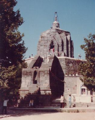
Shankracharya Temple
Shankarachar is a detached ridge of igneous rock to the south-east of
Srinagar, separated from the Shilamar Range by the Aita Gaj Gap. The summit
of the hill is crowned with a picturesque edifice. This hill was called
Jetha Larak and afterwards it was named Gopadari Hill. Some are of opinion
that the temple at the top was originally built by King Sandiman (2629-2564
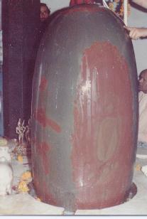
B.c.). There were 300 golden and silver images in it. About 1368 B.C. King
Gopadittya founder of Gopkar repaired it and bestowed to the Brahmans of
Arya Varta, agrahars which he built on its top. King Sandimati (34 B.C.-A.D.
13) improved and added to the temple. Zain-Ul-Abdin (1421-1472 A.D.)
repaired its roof which had tumbled down by an earthquake. Sheikh Ghulam
Mohi-Din, a Sikh Governor (1841-46) also repaired its dome. Recently, the
dome was repaired by Swami Shivratnanand saraswati at the request of a
Nepali Sadhu who gave him financial aid.
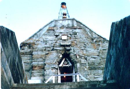
The temple is under the control of the Dharmartha Department. They have
built two small buildings for the sadhus who live there. There is at the
place an old stone shed which is called 'Parvatihund bana koth' (the
store-house of goddess Parvati).
The present name owes its origin to the great philosopher Shankaracharya who
visited the valley about ten centuries ago, and lodged at the top of this
hill, where it appears there were small sheds of Brahmans who looked after
the temple. There is a small tank built of slabs of stone just behind the
temple. In those days the Acharya or the Chief Preceptor or, in modern
parlance, the Chancellor of the University of Srinagar was Swami Abinaugupth.
A discussion took place between the two sages and according to the local
tradition Abinaugupth initiated Shankaracharya into the Shakti cult.
On the 20th April 1961 Shri Shankaracharia of Dwarika Pet installed the
white marble statue of Adi Shankaria just near the temple arranged by the
Dharmartha Department.
A climb to the hill from the Mission Hospital (now Government Hospital for
chest diseases) will take about 40 min. The path is a pony-track. The
descent towards the Gagribal spur is gentle. En route is the tomb of Mian
Dullo who is said to have squandered away all the money which his father had
given him to trade with. He was enamoured of the charms of the Dal Lake
which he selected as his favourite haunt for the gratification of his
epicurean appetites.
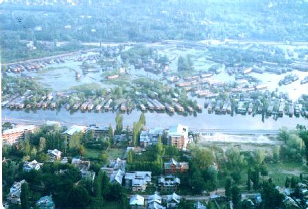
The panoramic view of the valley in early April when the snow is deep on the
mountains, or after rains on a summer day from the summit of the hill is one
of the best that could ever be witnessed. The mountain ranges on the south,
west and north rise one above the other and the peaks, varying in height
from 13,000-15,500 ft., jut out like the teeth of a saw cutting through the
sky. On the south lies the Banahal Pass (9,250 ft.) the chief highway to
Jummu, and a number of other passes and depressions. The Brahma Shakri
peaks, a group of grand cones viewed even from Lahore, the Aliabad Pass
(11,44o ft.) leading to Gujrat, the Romesh Thong (Sunset) Peak, Tata Koti
(15,540 ft.) guard the Chhoti Gali Pass (14,450 ft.) the highest in the
range, come one after another. We now turn our eyes to the west where lies
the vast plateau of Tosa Maidan, the paradise of sheep, and where the eye
meets the depression of Ferozpor leading into Punch (Prunts) and Apharwat
(13,542 ft.) giving shelter to Gulmarg and affording thrilling sport for the
votaries of ski-ing in India.
Beyond the Baramula Pass, towards the north-west, the range is continued in
Kaj Nag and Khagan mountain. In between the Tragbal (9,500 ft.) and Zoji La
(10,500 ft.) appears the beautiful candy cone of Harmoukh (16,842 ft.) in
the north, while the eastern range culminating in Mahadiv (13,013 ft.) and
Western peaks completes the enchanting circle. At the foot of these
mountains lie the alluvial plateaus with rich yellow soil yielding maize and
rice where water is available. The swamps, marshes and lakes of the valleys
stretch as far as the Wular Lake in the extreme north of the valley. The
Baramula road bordered with poplars, the sinuous course of the Vetasta (Jhelum),
cutting a clean almond called Shivapor Phur, the green house-tops now
disappearing with the introduction of galvanised iron sheets for roofs, the
minarets of churches and mosques and the shining surface of the temples
present a picturesque sight.
Turning now to the Dal lake we see the Moghul gardens of Nasim, Shalamar and
Nishat densely shaded by the deep green foliage of Boin (Chinar) trees, the
floating gardens and the houses situated on the islands in the lake
encompassed by poplars, willows and quince trees. The two expanses of deep
blue water are separated by the causeway like two great eyes, each with its
pupil of an island. The eastern shore is embellished by the magnificent
Royal Palace with their crystal sheen, by newly-laid gardens and the
boulevard skirting it. A part of the palace has been converted into a hotel
with a superb view.
The Government has made the hill a resort and it is hoped that it will one
day be clothed with dense herbage and trees Providing charming bowers for
lovers. A number of paths has been marked out and platforms with suitable
seats have been made for visitors. In fact, every effort is made to attract
people to the hill.
In olden days a great festival used to be held by the Hindus on the ioth day
of the lunar fortnight of Baisak which corresponds to March. Just above the
Dal Gate they would come in doonga's to bathe. This was called Monda daham,
probably in memory of the killing of the demon Mond by the goddess Sharika.
But this festival has now been entirely forgotten as if nothing like it ever
existed.