|
|
 |
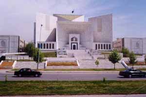
Islamabad = The City of Peace
|
|
|
Islamabad, the capital of Pakistan, is located against the backdrop of Margalla Hills at the northern edge of Potohar Plateau. In contrast to its twin city Rawalpindi, it is lush green, spacious and peaceful. Islamabad is a city of wide, tree-lined streets, large houses, elegant public buildings and well-organized bazaars. Traffic jams and crowds are rare, and narrow lanes and slums are few and far between. Sidewalks are shaded and safe behind rows of flame trees, jacaranda and hibiscus. Roses, jasmine and bougainvillea fill the many parks, and scenic viewpoints show the city to its best advantage.
The master plan of this most modern city was prepared in 1960 by M/s. Constantinos Doxiades, a Greek firm of Architects.
Construction was started in October 1961. The city came into life on 26 October 1966, when the first office building of Islamabad was occupied. It is a modern and carefully planned city. There are ample opportunities for walking, jogging, hiking and trekking around Islamabad in the Margalla Hills. The Margalla Hill range offers excellent opportunities for short and long hikes with magnificent vistas opening up on all sides. A network of trails having more then 120 kms total length has been developed.
The urban area is divided into eight zones: administrative, diplomatic, residential, institutional, industrial, commercial, greenbelt, and a national park that includes an Olympic village and gardens and dairy, poultry, and vegetable farms, as well as such as the Atomic Research Institute and the National Health Center. The name Islamabad (City of Islam, or City of Peace) was chosen the reflect the country's ideology.
ROSE AND JASMINE GARDEN
This 20,360 sq. meters rose garden is famous for its roses. It has
250 different varieties of roses as well as a dozen types of Jasmines, Flower
shows are occasionally held here, particularly during spring. Nearby is the
Tourist Camping Site.
SHAKARPARIAN HILLS
Shakarparian hills are situated near Zero Point, at a height of 609
meters. Its terraced garden offers pleasant and sweeping vistas of Margalla and
Murree hills, Rawal Lake, Rawalpindi and Islamabad, Snack Bar facilities are
available.
DAMAN-E-KOH
This low hill over looking Islamabad, known as Daman-e-Koh, offers
panoramic view of Islamabad. Snack bar facilities are available at PTD’s
Daman-e-Koh Restaurant. The place is ideal for afternoon and evening outing with
family and friends.
MURGHZAR MINI ZOO AND CHILDREN’S PARK
Murghzar Mini Zoo is located at
the foot of Daman-e-Koh viewpoint. A display corner of Pakistan Museum of
Natural History and a Japanese style children’s park have also been
established near the Zoo. The Park is a gift to Pakistani children from the
children of Japan.
ISLAMABAD SPORTS COMPLEX
A Sports Complex comprising Liaquat Gymnasium for indoor games and Jinnah Stadium for outdoor games has been built with the Chinese assistance. It is located on Shahrah-e-Kashmir near Aabpara. Regular national and international sports events are held in the Complex. For details, please contact Pakistan Sports Board, Islamabad Sports Complex, Shahrah-e-Kashmir, Islamabad.
PNCA Art Gallery
Idara Saqafat-e-Pakistan (Pakistan National Council of the Arts) runs two art galleries. The National Gallery is located at House # 77, Street # 48, F-7/4, Islamabad (Tel: 9204951), where contemporary Pakistani art is on permanent display besides revolving exhibitions & paintings available for sale. The other is Children Art Palace, # 77 School Road, F-7/4, Islamabad (Tel: 221286), where Children's art is on display and regular art classes held for children.
Pakistan Museum of Natural History
The Museum of Natural History is located in the National Park on Garden Avenue, Shakarparian, Islamabad. The Museum depicts the early human history, geology, and the wild life of Pakistan. The exhibits are of particular interest to students and children. It is open to public from 9:00 a.m. to 4:00 p.m. except Friday. Entry is free.
Islamabad Museum
Islamabad museum presents a long historic sequence of the land where Pakistan is situated today. Pakistan has been a seat of the world's leading civilizations from the time immemorial. There is plenty of evidence to support this argument now on display in Islamabad Museum. For example, 20 million years old fossil remains, 2 million years old man-made stone tools, 7000 years old early human settlements which lead to the world famous Indus Civilization, Gandhara Grave Culture and Gandhara art, early Islamic settlements, Sultanate and Mughal period, their art and craft.
The Museum is located at Garden Avenue, Shakarparian, Islamabad. It is open for visitors, Thursday to Tuesday, from 09:30 to 16:30 hrs without break. Wednesday is weekly off and there is a prayer break on every Friday from 12:30 to 14:00 hrs.
Lok Virsa Museum & Heritage Library
The Lok Virsa (National Institute of Folk & Traditional Heritage) works towards preserving the living folk and traditional culture of Pakistan. Its Folk Heritage Museum, located near Shakarparian Hills, has a large display of embroidered costumes, jewellery, woodwork, metalwork, block printing, ivory and bone work. Traditional architecture facades exhibiting such skills as fresco, mirror work, marble inlay, tile mosaic and stucco tracery are also displayed. Lok Virsa Heritage Reference Library is equipped with resource data on ethnography, anthropology, folk music, art, history and crafts. Museum and Library timings are: 8:30 a.m. to 4:00 p.m. Friday closed. (Tel: 9201651, 9203983). Books on culture, heritage, audio and video cassettes of folk and classical vocal and instrumental music are available for sale at Lok Virsa's Sales Centre.
LOK VIRSA
The Lok Virsa (National Institute
of Folk and Traditional Heritage) works towards preserving the living folk and
traditional culture of Pakistan. Its Folk Heritage Museum, located near
Shakarparian Hills, has a large display of embroidered costumes.
Jewellery, woodwork, metalwork, block printing, ivory and bone work. Traditional
architecture facades exhibiting such skills as fresco, mirror work, marble
inlay, tile mosaic and stucco tracery are also displayed. Lok Virsa Heritage
Reference Library is equipped with resource data on ethnography, anthropology
folk music, art, history and crafts. Museum and Library timings are 8:30 a.m. to
4.00 p.m. Sunday closed (Tel: 9201651, 9203983). Books on culture and heritage,
audio and video cassettes of folk and classical vocal and instrumental music are
available for sale at Lok Virsa’s Sales Centre, also located near the Museum.
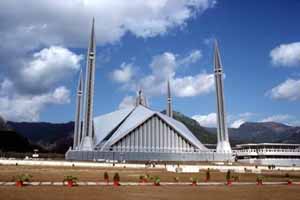
Shah Faisal Mosque
This beautiful mosque was designed by a renowned Turkish Architect, Vedat Dalokay and named after the late King Faisal of Saudi Arabia. It is spread over 1,89,705 sq.metres with 88 meters high minarets and 40 meters high main prayer hall. The main prayer hall can accommodate 10,000 persons while the covered porticos and verandahs can take over 24,000 worshipers. The main courtyard has space for 40,000 people.Shrine of Shah Abdul Latif (Bari Imam)
Noorpur Shahan, a village situated at the foot of Margallah Hills, near Qaid-e-Azam University, is famous for the mirror-studded shrine of Hazrat Shah Abdul Latif Kazmi, popularly known as Bari Imam. The shrine was originally built on the orders of Mughal emperor Aurangzeb. The death anniversary (Urs) of Bari Imam is observed in the first week of May beginning Monday through Thursday with lot of festivities representing the Potohar culture and attracts people from all over the country.
There is a cave in the Margallah Hills on the back of the shrine where Bari Imam used to sit for meditation. A mosque, where he preached and acted as Imam, is located on Hill Road. The tomb of his father is located on the Shahrah-e-Kashmir opposite the Aabpara Market. Bari Imam is said to have predicted that a new city would be built near his tomb, which will greatly serve the cause of Islam.
Shrine of Syed Meher Ali Shah
The shrine of Syed Meher Ali Shah of Golra Sharif is located 18 km from Rawalpindi, in sector E-11 of Islamabad. He was descendant of a Syed family and had links with Syed Abdul Qadir Gilani of Baghdad. He was born in 1859, preached and spread the message of Islam during the turbulent times in South Asia. He also wrote beautiful prose and poetry in Persian, Arabic and Punjabi languages, mostly in praise of God and Muhammad (peace be upon him). He died on May 11, 1937. His mausoleum was recently reconstructed comprising of a dome, and a high minaret built with marble. Devotees assemble here on the occasion of annual Urs.
Rawal Lake
This glistening man-made lake covers an area of 8.8 sq. km. The terraced garden and the lake are ideal for picnic, fishing and boating. The highest point in the garden commands a panoramic view of the lake, Margallah and Murree hills, Rawalpindi and Islamabad. The PTDC Jaltarang Restaurant offers snack bar facilities for visitors.
Khanpur Lake
This beautiful lake/dam is 48 km from Islamabad, on Taxila-Haripur Road. It is an ideal place for day trip/picnic, boating, angling and watching migratory birds during winter.
Simli Lake
About 30 km from Islamabad lies Simli Lake and the Dam. It can be reached via Lehtrar road or via Bhara Kahu. It is fed by the melting snow and natural springs of Murree hills. The water stored in the lake is supplied to Islamabad for drinking purposes. Angling and boating is also allowed in the lake. The Capital Development Authority (CDA) has a Rest House at the Dam, which can be booked through its Head Office in Islamabad.
Misriot Dam
Misriot dam is located 12 km south-west of Rawalpindi. This small dam has an artificial lake with boating and fishing facilities. Fishing permit may be obtained from fishing guard at Misriot. It has a pleasant landscape and walkways beyond the lake among eruptions of black rocks.
Tanaza Dam
It is a small dam located at about 35 Km south-west of Rawalpindi on Dhamial Road. Ideal for a day trip, the lake has a quiet atmosphere.
Tarbela Dam
The world's largest earth-filled dam on one of the world's most important rivers - the Indus - is 103 km from Rawalpindi. The dam was completed in 1976 at a cost of Rs.18.5 billion. Over 15,000 Pakistani and 800 foreign workers and engineers worked during its construction. It is the biggest hydel power station in Pakistan having a capacity of generating 3,478 MW of electricity. Its reservoir is 97 km long with a depth of 137 meters while total area of the lake is 260 sq.km. Permits are required for visiting the Dam. Please contact Public Relations Officer (PRO), Water and Power Development Authority (WAPDA), Tarbela (Tel: 051-568941-2). A No-Objection Certificate (NOC) from the Ministry of Interior (Shaheed-e-Millat Sectt.), Islamabad is also required for foreign visitors.
Mangla Dam
World's third largest earth-filled dam is only 115 km south-east of Rawalpindi. One has to turn left from Dina Town and the dam on river Jhelum is about 14 km to the east. The dam is 3,353 meters long and 116 meters high above the river bed. It is designed to store 5.88 MAF water and also used for power generation. In the centre of the dam there is a Gakkhar Fort from where one can have a panoramic view of the lake. For permit to visit the dam, please contact PRO, WAPDA, Mangla. A NOC from the Ministry of Interior is required for foreigners only.
Rawat Fort
Rawat Fort is located 17 km east of Rawalpindi, on the Grand Trunk (G.T) Road leading to Lahore. Gakkhars, a fiercely independent tribe of the Potohar Plateau built the fort, in early 16th century. The grave of a Gakkhar Chief, Sultan Sarang Khan is located inside the fort. He died in 1546 AD fighting against the forces of Sher Shah Suri. If one dares to climb the broken steps inside the tomb, one may get a panoramic view of the plateau and the Mankiala Stupa.
Pharwala Fort
This fort is about 40 km from Rawalpindi beyond Lehtrar road. A Gakkhar ruler, Sultan Kai Gohar, on the ruins of a 10th century Hindi Shahi Fort built it in 15th century. Emperor Babar conquered the fort in 1519 AD. Later, in 1825, Sikhs expelled Gakkhars from this fort. Though the fort is in a crumbling state, it is still an attraction for castle lovers. The fort, being situated in prohibited area, is only open for Pakistani visitors.
Rohtas Fort
Rohtas Fort is 109 km from Rawalpindi. It is located about 6 km south-west of Dina Town. Going from Rawalpindi/Islamabad, you have to turn right from G.T. Road to a narrow road just before Dina Police Station and then go left until you find the dry bed of Kahan River. The fort is visible from this point. However, you have to cross the river to reach it. During rainy season, you need a four-wheel-drive to cross the river. The fort is one of the most impressive historical monuments in Pakistan. It was built by Afghan ruler Sher Shah Suri, between 1540 and 1547 AD. It served as a huge fortified base for military operations against Gakkhars by Sher Shah Suri. It was later used by Mughal emperor Akbar and Sikhs. Within the huge terraced rampart walls with robust bastions and twelve gates, is located another fortress, palaces and ancillary buildings.
Attock Fort
It is situated about 101 km west of Islamabad on the left bank of Indus River. The fort was completed in 1583 under the supervision of Khawaja Shamsuddin Khawafi, a minister of Emperor Akbar. The Mughal caravan sarai outside the fort, which is almost on the G.T. Road, was also built during this period. Please note that no visitors are allowed inside the Fort.
Giri Fort
The glen of Giri is located 8 km north-east of Taxila, at the foot of Margallah. It is approached through a rough torrent bed near two villages named Khurram Gujar and Khurram Paracha. There are remains of two monasteries and stupas, one on the top of the hill and other below it. The remains of Giri Fort are perched on the hill top, with spring water falling within it. The fort was built in 5th century by the Buddhist monks. Later, it was used by Sultan Masud, son of Sultan Mahmud of Gazni.
![]()