In this project, there is an
attempt to study the notion of urban cove. In other words the vacant concave
space in the interior of a city that remains, in its greatest part, without
artificial intervensions, conserving its natural substance.
These are the spaces that for various reasons (mainly historical, social and
political) that haven't followed the artificial reconstruction of the city
and conserve a natural, dynamic condition. These spaces, although they systematically
accept the thoughtlessness of the citizens and of the urban social public
life, are stamped by the dynamism of its unadulterated, uncontrollable natural
growth. In this case, the urban cove that we are studying, neighbors with
a very powerful and important natural substance of the city, the hill of Lecabetus.
It is in touch in such a way with the hill so that it can be considered (and
can be lived) as its natural unfoldment, as its continuance.
Its direct dependence to the hill (and because of its similar intense inclination)
allows us to try to confute the classical compositional architectural elements
that we use in the designing and to be canalized towards the formulation of
some new compositional instruments that are based to the "schematization
of the view". We will try first of all to analyze and afterwards to interfere
to it having as a base and instrument the human view towards the natural and
urban landscape.
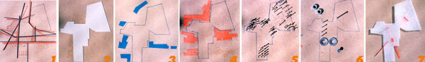
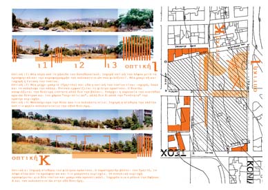
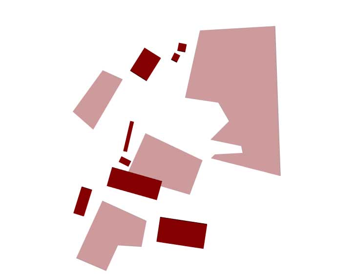
In the plans, the points of photo shootings are marked (that are identical
to the paramount, according to the analysis, views) together with the buildings
or the natural elements that are considered as very important in any occasion.
There is an attempt to register the continuities and the discontinuities of
the space, its big surfaces and the rhythms that are naturally created.
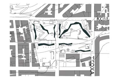
The next step of the analysis leads i) to the specification of the selected
points on the urban cove where certain spaces from constructive elements will
be installed and ii) to the directions that we want to drive the eyesight.
Consequence of the foresaid is the composition of a plan in which the basic
intentions of the designing are recorded.
The functions that will be hosted will be mainly for recreation and information;
they will be organized on certain constructions. The aim is the natural element
to be accented, the relaxed walk to be favored and the view to be guided towards
the distant points of interest of the city (and not to be exclusively focused
on the interior of the urban cove). From all these, someone can conclude that
designing is trying to propose to the user a subjective view of the urban
environment.
In the pictures, the compositional elements that are chosen and the points
of interest and of intervention are intensively analysed. Furthermore, a graphic
annotation of the views that each point provides, is presented.
Public's space topology.
Public space includes a series
of simultaneous schematizations that define in it materialistic, as well as
notional limits. It practically means that every meaning using public space
as a field for unfolding its semblance, every perception that interprets it,
recognizes in it different limits and different materiality.
This assumption premises an approach of the public space's meaning, not only
in terms of geometry, common geometrical characteristics and of a common subjective
space. But an approach in terms of topology. This means in terms of searching
of interpretational characteristics: notional and perceptional limits, limits
of influence, passages of connections and correlations.
These different schematizations come from a quantity of factors that define
successive layers of meanings that at the same time act as force application
fields.
We can therefore represent the public space as a multilayer scheme, a machine
to create not only one but many meanings that can coincide supplement or strike
together. The factors participating in this machine are those that create
the complicity of the city, of the urban environment.
Public's space "programmatic diagram".
In the case that we endeavour,
through the designing of public space, to search for the different forces
that influence, to map the notional limits and in this way to schematize designing
proposals, important phases in the designing can be the programmatic formulation
of the forces and its notions, the constitution of the designing program that
in the same time interprets and proposes. It interprets this multilayer scheme
through which the space is loaded and proposes designing strategies.
The program of the public space is the most crucial factor of its design.
As program we mean the different layers that predefine the activity and the
notional content of the public space. The foresaid layers can be layers of
uses and also layers of perception and layers of public space meaning. These
are that coexisting can create different pairs of meaning like public - private,
natural - artificial, material - notional.
In the programmatic environment of designing there is a need of a compositional
instrument with topological characteristics that can imprint relations, connections,
forces and in the same time can function as a creating machine for new meanings,
can provision the designing. The diagram can install that type of "thought
mechanism".
This way a very important function is defined, the diagrammatic imprinting
of a multilayer programmatic scheme that is constituted by the layers of the
program that each of them schematize a different function, perception, meaning
and also the natural limits of the public space, its materiality.
The diagram formulation of that scheme can be extremely important for the
designing. We could name it "programmatic diagram".
The analytical mapping of the meanings' field that contains the programmatic
diagram as a compositional instrument, hides one more value for the designing:
Each of these fields can, from the one side, be autonomized, opening independent
fields of questioning for the public space (the planting, the housing, the
networks, the value of the ground etc), producing questions that can, for
the other side, re-embody and re-provision the programmatic model.
A compositional proposal for "surface".
We tried during the elaboration
of the proposal to enroll in it the procedure of the "empty square",
the procedure that brings in comparison and correlates the heterogeneous series
of signs as Deleuze mentions. In parallel, designing can put in motion a procedure
that won't accept the predefined production of images and prototypes of the
public space and its elaboration for the same the users.
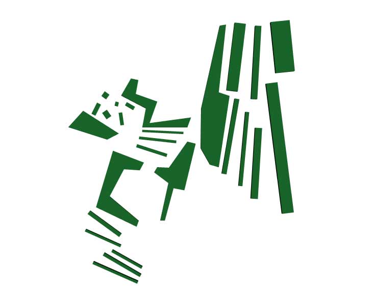
This, compositionally, is attempted with the help of conductors that pierce,
dig out or alter the multilayer scheme of the public space (the "urban
worms" or "urban conductors"). So, from the one side, it shows
forth its superficiality and, from the other side, it proposes a theory that
accepts the notion of public space as something that is permanently under
negotiation. The depth in this case is perceived as a discovery of an other
surface under the surface, in an unlimited game of surfaces' succession. An
apparentness game.
These conductors practically bring that procedure of image production, production
of communication, of public space memory administration, the whole "non-material"
piece of life in public space that today, with the new media, can be collectively
experienced.
These conductors, in the logic of installation of interdependence between
the different layers of the program, can install ephemeral constructions that
"alter" the layers (in public building, housing, transportation
etc) in relation with the surface of public space.
Each of these layers, with its material or non intervention in the foresaid
empty space of the city, schematize different limits of public space, always
having as a background, the surface (the planting, the boundaries that defines
the schools and the stadium) and the different notional dimensions of space.
The public buildings of the area (schools, stadium) redefined designingly,
in order to be included in the foresaid relation of interdependence with the
surface. The schools permit to the surface to go through them as a carpet,
while in the case of the stadium, the surface surpass the space (which is
downgraded) and covers part of it.
Finally, the surface of the certain place is camouflaged, as natural ground,
in order to be a continuance to the natural space of Lycabetus and of other
neighbouring empty spaces of free vegetation or parks, giving the opportunity
for the creation of a network of united public spaces. A different network
of movement and public uses inside the urban net.