 |
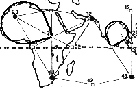
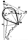
| So, it should be visible to "those with eyes to see" that the Global Grid is very obviously shaping these land structures. If you look at South America, for example, you can see the extremely obvious effect of this particular "grid triangle," in literally forming the continent around itself. In looking at the southernmost tip of South America, you can see how the force of node number 58 pushes the land away from its due south trend and towards the east. Then, if you look at node 49, on the middle of the East Coast of South America near Rio de Janeiro, you can clearly see how the force of the node has pushed the landmass of the continent into a rounded shape. Then, looking at Australia, you can clearly see that the whole continent, and especially the northwest side, forms very precisely within the stretching forces of this area of the Global Grid. Here, if we look to the exact north and middle of Australia on point 27, we see a circular "node point" displacing the land around it and forming the Gulf of Carpenteria. Again, the nodes themselves have shaped the land into circular "vortices," repelling the continental mass from themselves and in this case, also shaping the outline of the island directly above Australia. These circular forms, as we shall continue to see, are consistently visible in conjunction with the Global Grid. We saw them in Egypt on our chapter regarding Carl Munck, forming the Nile River coastline on the Mediterranean. Also, node 44 is precisely aligned with the bottom of Antarctica, and we see either edge "drooping" to the right or the left from this. According to Richard Lefors Clark, this is the "bowtie" energetic configuration showing itself in the Australian landmass, which he calls a "diamagnetic energy vortex." We will examine how such a shape could be formed by the curved, spiraling energies that make up the grid below. Clark also shows us that the Gulf of Mexico follows this same curving energetic organization, as well as the two coastlines of the continental United States. Next, look at Africa, and see the combined action of two larger triangles, one with the point facing downwards on the African continent and its neighbor pointing upwards, girding the Indian Sea: |
 |
| In the following quote, they explain in precise terms exactly what they did: We propose that the planetary grid map outlined by the Russian team Goncharov, Morozov and Makarov is essentially correct, with its overall organization anchored to the north and south axial poles and the Great Pyramid at Gizeh. The Russian map, however, lacks completeness, in our opinion, which can be accomplished by the overlaying of a complex, icosahedrally-derived, spherical polyhedron developed by R. Buckminster Fuller. In his book Synergetics 2, he called it the "Composite of Primary and Secondary Icosahedron Great Circle Sets." We have shortened that to Unified Vector Geometry (UVG) 120 sphere� We use the number 120 due to its easy comprehension as a spherical polyhedron with 120 identical triangles - all approximately 30, 60 and 90 in composition. And now, the moment we've all been waiting for: the Becker / Hagens grid, which finally "cracked the code" of the Platonic Solids' positions on Earth. Right away, you should be able to see the amazing correspondences of this Grid to the physical forms of the continents, among other things. |
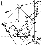
| Again, we see Dr. Lefors Clark's bow-shaped "diamagnetic energy vortex" shaping the land in a smooth curve. We can also see the same curving formation created by the east coast of India and the west coast of the China / Korea / Vietnam area of Asia. This vortex is balanced between points 24 and 13. We remind ourselves that these smooth curves illustrate the spiraling nature of the superstrings that make up these geometric energy fields, here expressed as spiraling lines of magnetic force. Let us remind ourselves that Clark's primary example of this bowtie energy is that which occurs in the general area of the Bermuda Triangle, with its opposite pole forming the eastern coast of Mexico. According to Dr. Clark, the point at the center of the "bowtie" becomes a magnetic null zone of zero gravity when appropriately triggered by the right geometric positions of the Sun, Moon and Planets to the Earth. In those moments of conjunction, there is a "hyperdimensional bleed-through," and we then get time dilations, disappearances, gravity loss, levitation and other related phenomena. Haven't had enough? Still not convinced? No problem. Check out the next three pictures, showing the circular grid energy formations surrounding the east coast of China and surrounding area: Honestly, when you know what you are looking for, and you have the Grid map, they really do jump right out at you! In picture number 1, we have our straight grid map of China for comparison. Picture 2 has three circular vortexes in it. We have already discussed the bottom left vortex in India and China. Then, the center vortex shapes the East Coast of China, based off of and emanating from point 13. |
| By noThe following credits need to be given when reprinting this photo: The Planetary Grid System shown [here] was inspired by an original article by Christopher Bird, "Planetary Grid," published in New Age Journal #5, May 1975, pp. 36-41. The hexakis icosahedron grid, coordinate calculations, and point classification system are the original research of Bethe Hagens and William S. Becker. These materials are distributed with permission of the authors by Conservative Technology Intl. in cooperation with Governors State University, Division of Intercultural Studies, University Park, Illinois 60466 312/534-5000 x2455. This map may be reproduced if they are distributed without charge and if acknowledgement is given to Governors State University (address included) and Mr. Bird. It becomes immediately obvious that this Grid indeed controls the positioning of continental landmass on the Earth. Our favorite examples, both of which combine "nodes" and force lines, are South America and Australia. See the detail in this next picture below. |
| (It's funny to think that someday this is going to be in boring textbooks, being read by Kindergartners, isn't it?) Anyway, the downward-pointing triangle certainly describes Africa well, and the extra land on the western side can be explained by the pressure coming from the Mid-Atlantic Ridge, which is almost precisely the same as the Atlantic grid line formed by points 10, 19, 37, 38, 39 and 50. The east coast of Africa and Saudi Arabia follow the eastern side of the triangle very nicely, on the grid line from point 41 to point 12. We can also see how node point 22 gently pushes in on Africa's east coast, causing it to dip inwards as it travels and forming the Somalia Basin. We can also assume that the "cracks" separating Africa and Saudi Arabia were caused by the expansion of the Grid, forcefully pulling the land into alignment. The "crack" to the immediate left of point 12 follows the grid line exactly. And finally, the upward-pointing triangle can be clearly seen to cut its way right into the land, with Africa's coast defining its left side and India's coast defining its right. In this next illustration, we can see how point 21, in the center of the African continent, works with its above-right partner point 20 in providing a framework for the bow-shaped energy vortex that shaped the northeast coast of Africa. Point 20 is the only "vile vortex" that is significantly inland; 41, near South Africa, and 42, near India, are the only others that touch land at all! This is probably due to the incredible strength that they possess, which seems to repel landmasses. We can see how the northeast coast of Africa is indeed very circular, and point 20 is directly at the center of this "bowtie" of energy. |
 |
 |
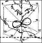
| Although it is absolutely mind-boggling, we can see that an elliptical-shaped gravity field is clearly visible when the center is placed directly in node 15. If we use any standard image editing program and "drag out" an ellipse using point 15 as a center, we can indeed align it precisely with the island formations to the far west of our diagram. We can see the amazing connections of this energy formation as soon as we start looking at the diagram. We can try other center points besides 15, but the ellipse will not fit anywhere else as precisely as it does right at that spot. Right away, we should see that this massive energy vortex seems to provide the clearest Grid counterpart for the existence of the Ring of Fire, which is a ring of volcanoes and tectonic activity surrounding the Pacific Ocean. When we look at this "grid ring" carefully, we can see that it represents the perfect fusion between the Earth's landmasses and the Global Grid. Going clockwise from the 12:00 point, the ring will perfectly touch a "square" of grid points, as 7, 31, 27 and 5. (Node point 27, near Australia, is the only one that isn't touched exactly. We can also see that this ellipse is well defined by points 14 and 16, again Sanderson's incredibly powerful "vile vortices," the points of the icosahedron. We have already seen how the incredible gravitational force of these "vortices" was able to shape the entire upper Western half of Africa into an elegant, circular shape. Now, we are seeing two of these vortices working together to form an even larger shape. The ring forms part of the East Coast of China, as well as a good part of the upper Russian coastline surrounding node 5. It also defines part of the southern coastline of Alaska. Perhaps most interesting of all is that the combination of forces that are demonstrating themselves in this map look very familiar to a microscopic formation in nature. Take another look and you will see it� Cell Mitosis! We can certainly see that Mother Earth is giving all Her secrets away, right in front of our very eyes, if only we understand Her Grid. The grid points 14 and 16 would be akin to the two poles of the dividing cell. The gridlines provide us with a simplified depiction of the "spindle fibers" that form in cell mitosis. The actual ring of energy that is created forms a precise analog of the nuclear membrane of the cell, as it continues its expanding, elliptical process of division. |
| If the reader wishes to see more of the connections between the Becker / Hagens grid and the landmasses, simply stare at the map for a while and they start popping out. The reader will remember that in previous chapters, we showed the "grid bands" on the Earth and how their effects shaped the Ring of Fire, the flowing of the Nile River, the "node point" of the Egyptian northern coast centered in Giza, and the vertical structure of the Yucatan Peninsula. Now, with the full map of the Becker / Hagens grid, we can see a great deal more from the effect of these straight longitudinal lines. As one example, by referring back to the main map, the reader can clearly see that the entire Eastern side of Hudson Bay in Canada precisely follows the line from 18 in Florida to 9 in the Bay to 61 at the North Pole. Furthermore, all of England is precisely within the line created by point 20 in Africa, through point 11 in England to point 61 at the North Pole. So, there are a variety of ways to see this energy at work on Earth. One can begin to visualize this Grid energy as a living net of "wires" that are tightly stretched over a thin balloon. It is obvious to us that what we think of as randomly placed continents are actually conforming to this massive energy. As you look at the different diagrams of how these geometric energies show up on Earth, you do indeed get a sense of the massive forces that are involved with this Grid. We know that gravity is not the full extent of these forces, either, as they can be shown to have profound effects on human consciousness. Becker / Hagens explain how these Grid points also seem to attract large population centers. |
 |
 |
| The uppermost and largest vortex in Picture 2 shapes the entire Japanese and Russian archipelago, and is centered in and emanating from point 4. Finally, in picture number 3 we have a vortex centered in Sanderson's "vile vortex" near Japan, the "Devil's Sea," here listed as point 14. This vortex is "equalized" by points 25 and 26, both of which are equidistant from the edge of the circle. And obviously, the Philippines precisely traces the bottom left of the circle itself. This is obviously a very strong vortex to be able to shape the land of the Philippines from where it stands. According to Becker and Hagens, Another area of continuing disappearances and mysterious time-warps is the Devil's Sea located east of Japan between Iwo Jima and Marcus Island. Here events have become so sinister that the Japanese government has officially designated the area a danger zone. This area was significant enough to the work of Bermuda Triangle author Charles Berlitz that he wrote a whole book dedicated to it and the "bigger picture," entitled The Devil's Triangle. It is becoming more and more clear that our geometric shapes, expressed as the consciousness unit expanded to a planetary scale, are far more than abstract concepts of theoretical physics. What we have here are direct, quantifiable and measurable phenomena, and these geometry-based Grid patterns are simply the simplest, and therefore the best solution to the problem. |
| We have shown that a pyramid is actually a physical, crystalline structure that is built to be identical to our own native dimensional frequency of the octahedron, for the purposes of harnessing energy. The Wilcock reading in chapter 17 told us that the circle shape of stoneworks like Stonehenge and earthworks like the Mound Builders' creations in Florida also work to harmonize with this upward-spiraling Earth energy. Again getting back to our discussion of Dr. Clark's information, we can look back to the South American landmass. Not only does it fit perfectly within our "Grid Triangle," but we can see yet another example of this circular, "bowtie-shaped" energy at work in the actual shaping of the landmass itself. |