| 7.4 Magnitude E A R T H Q U A K E hits the Caribbean Region - see Maps Below |
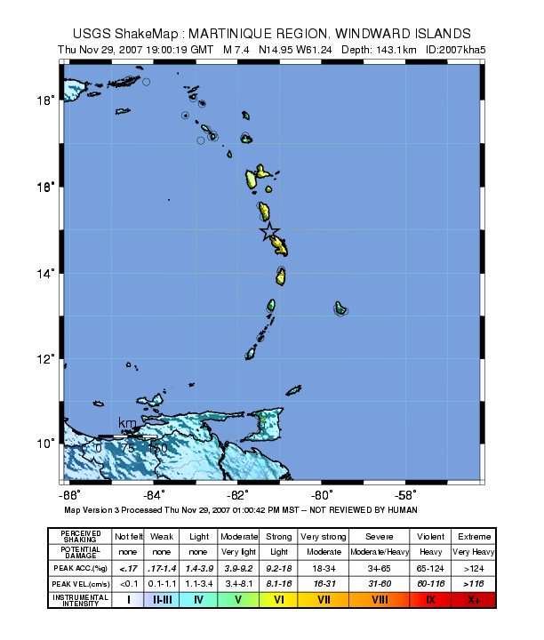
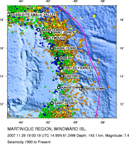
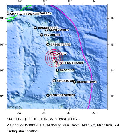
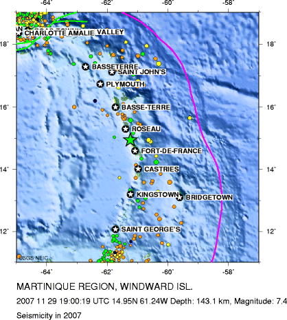
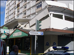
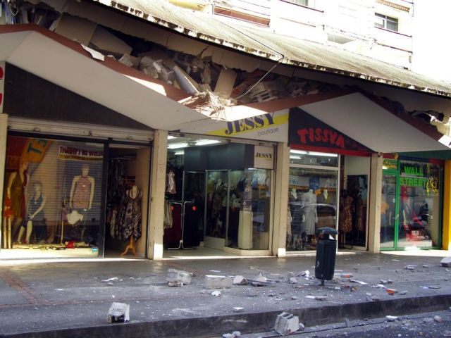
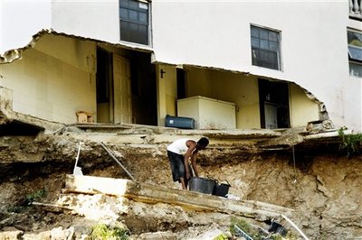
| The Event: NNC News Cast items on Earthquake & End of the Hurricane season On Thursday afternoon 29th November at 3:00 p.m. local time, an earthquake occurred off the east coast of Martinique. The preliminary location for the event is 14.70�N 60.89�W, the focal depth is 121km and the preliminary magnitude is 7.3, later updated to 7.4. Reports have indicated that the earthquake was widely felt across the eastern Caribbean as far in the north as BVI and as far south as Guyana. This is one of the largest events to be recorded in the Eastern Caribbean in historic times. This was the fifth earthquake of similar size to occur in this area since 1727 and the largest earthquake recorded since the magnitude 7.5 event which occurred in 1974 near Antigua. There were no threats of a tsunami from this event. No damage has been reported in Nevis, However cell phone service was temporarily disrupted for a few hours. The general public was informed by radio of the event, its magnitude and location, within 15 minutes of the event by the Nevis Disaster Management Department officials. The quake was located 176 miles ESE from Nevis, 270 km (168 miles) NW (320�) from Bridgetown, Barbados, 42 km (26 miles) SSE (159�) from Roseau, Dominica. Three likely aftershocks occurred at 3:35 p.m., 4:11 p.m. and 12:00 midnight in the Windward Islands of magnitudes 5.0, 4.8 and 5.1 respectively. An earthquake of magnitude 4.8 was felt the previous day on Wednesday, November 28, 2007 at 10:18 a.m. with its epicentre located 45 miles North East of the capital of Martinique and 60 miles ESE of Roseau, Dominica. As of Friday 30th Nov, there have been at least 8 aftershocks following the 2007/11/29 main shock, with a magnitude range of 3.5-4.8. There have been no reports of these aftershocks being felt. The Eastern Caribbean will continue to experience earthquakes in the future and as such citizens are encouraged to learn about earthquake safety measures and practice these through regular drills at home, school and work. Updates on earthquakes in the Eastern Caribbean and information on Source of Information includes the Seismic Research Unit, UWI = = = = = = = = = = = = = = = = = = = = = = = = = = = = = = = = = = = = = = = = = = = = = = = = = = = = Tectonic Summary (from United States Geological Survey, USGS) The Martinique earthquake 29 November 2007 occurred in the inclined seismic zone that dips to the west beneath the Lesser Antilles islands arc. In the region of Martinique, the South America plate moves to the west-northwest with respect to the Caribbean plate with a velocity of about 2 cm/yr. This relative motion is accommodated largely by the South America plate thrusting beneath the Caribbean plate. The earthquake occurred within the subducted South America plate, in response to stresses generated by plate's slow distortion, rather on the thrust fault that constitutes the interface the between the Caribbean and South America plates. The subducted South American plate is seismically active to depths of almost 200 km beneath the Lesser Antilles island arc near Martinique. Earthquakes, such as this one, that have focal-depths between 70 and 300 km are commonly termed "intermediate-depth" earthquakes. Intermediate-depth earthquakes typically cause less damage on the ground surface above their foci than is the case with similar magnitude shallow-focus earthquakes, but large intermediate-depth earthquakes may be damaging nonetheless and may be felt at great distance from their epicenters. |
 |
 |
 |
 |
| HISTORIC INFORMATION: The Leeward Island earthquake of October 8, 1974 The Leeward Island earthquake of October 8, 1974, produced the strongest shaking in several of the Leeward Islands since the great earthquake of February 8, 1843. The 1974 earthquake had a magnitude of 7.5, making it one of the largest earthquakes of the year, worldwide, in terms of seismic energy released at the earthquake source. Fortunately, the source was tens of kilometers from the nearest inhabited land. For this reason, damage was generally unspectacular, and there does not seem to have been loss of life. Damage was costliest on Antigua. The Cathedral of St. John, built at the site of the cathedral destroyed in the 1843 earthquake, suffered extensive damage to its masonry exterior. The new deepwater harbor facility at St. Johns, Antigua, was damaged by settling of the fill on which it was constructed. Equipment and buildings of the West Indies oil refinery, on the outskirts of St. Johns, were damaged, and thousands of barrels of crude oil leaked from tanks. Elsewhere, sparsely inhabited Barbuda was strongly shaken, On St. Kitts, the tower of the church of St. Thomas fell through the roof of the church causing serious damage, although the level of shaking which produced the tower collapse was probably less than the shaking at Barbuda and Antigua. The damage data from the Leeward Islands earthquake are valuable as guides to the interpretation of historical earthquakes. For the 1974 earthquake, we have damage data for both modern reinforced-concrete structures and for unreinforced masonry buildings which are more than a century old. For the historical earthquakes, we have damage information only for the unreinforced masonry structures. What the historical earthquakes might have done to modern structures must be inferred from the damage pattern of the 1974 earthquake. For example, it is clear that the 1983 earthquake caused destruction over a much wider area than the 1974 earthquake. In 1843, severe damage occurred at locations damaged by the 1974 earthquake and, in addition, at Montserrat, Nevis, English harbor (Antigua), and Guadeloupe (south of Antigua), which experienced little damage in the 1974 shock. In general, the duration of strong ground shaking in earthquakes increase with the size of the zone of damage caused by the earthquakes. It is probable, therefore, that strong ground motion in the 1843 earthquake lasted significantly longer than strong ground motion in the 1974 earthquake. Modern structures in the vicinity of the Leeward Island which are susceptible to damage from sustained strong or moderately strong ground motion would likely to be damaged much more from a repetition of the 1843 earthquake than they were in the earthquake of October 8, 1974. |
 |
 |
 |