
The US Army Corps of Engineers, Buffalo District, is to be highly praised for bringing in federal experts to critique wetland studies by Earth Dimensions, Inc. Developers and/or North Tonawanda taxpayers paid for these studies. The two cases presented on this page are the Briarwood subdivision (and related infrastructure) and the Klydel Wetland.
Sierra Club predicted that there could be problems with the Briarwood study as noted in these excerpts from public comments submitted to the North Tonawanda Planning Board at a July 5, 2005 public hearing:
"After receiving warning letters and stop work orders from regulatory agencies, the city has hired Earth Dimensions, Inc., to assess wetlands in the Briarwood area." ....
"We believe Earth Dimensions work should be subject to the most rigorous scrutiny as they were very inaccurate in their study of the Klydel Wetland that was submitted to the North Tonawanda planning commission in June 2000. The planning commission would not permit us to speak at that meeting to contest their inaccurate wetland delineation. Fortunately, federal experts from the US Army Corps of Engineers Waterways Experiment Station in Vicksburg, Mississippi visited the Meadow Drive project site in October 2000 to critique the Earth Dimensions wetland study."
"The federal experts concluded, hydric soils were more extensive on this site than indicated in the Earth Dimensions study. Wetland hydrology is more extensive on this site than was indicated by Earth Dimensions. And based on the evidence, Earth Dimensions, Inc., may have significantly underestimated the extent of wetlands on the Kinkead Avenue and Meadow Drive site.
Federal experts determined that Earth Dimensions understated the wetlands present on both project sites. In this first case, Briarwood, a wetland delineation map by Earth Dimensions has been updated by Corps' officials (below) to add "supplemental wetlands" that Earth Dimensions had failed to properly identify. This map was obtained under freedom of information law and is followed by detailed analysis by government soil scientist Steve Carlisle. Further down this web page are the critiques of the Klydel Wetland studies.

The remaining documents on this page refer to critiques by federal experts to an Earth Dimensions study of the Klydel Wetland near Meadow Drive and Kinkead Ave. in North Tonawanda. Again, government experts found that this study that was paid for by the developer underestimated wetlands by incorrectly interpreting wetland soils.
CEERD-EE-W
7 December 2000
MEMORANDUM FOR RECORD
SUBJECT: Wetland Determination at Kinkead Avenue and Meadow Drive, North Tonawanda, NY (WRAP 01-1)
At the request of the Regulatory Branch of the U. S. Army Engineer District, Buffalo, NY (the Buffalo District), I visited the undeveloped property at Kinkead Avenue and Meadow Drive, North Tonawanda, NY. The owner has proposed to develop a portion of the property near Meadow Drive. A consulting firm, Earth Dimensions, Inc., Elma, NY, performed a wetland delineation on the property in September 1999 and concluded that 3.24 acres of the approximately 18-acre tract were wetlands potentially regulated under the federal Clean Water Act, and that most of this wetland acreage was outside the portion proposed for development. However, the consultant's wetland delineation differed considerably from that performed by personnel of the NY Department of Environmental Conservation (NYDEC) pursuant to State regulations. NYDEC concluded that portions of the area proposed for development contained regulated wetlands.
Through the Wetland Regulatory Assistance Program (WRAP), the Buffalo District asked for assistance from the Environmental Laboratory of the U. S. Army Engineer Research and Development Center, Vicksburg, MS, in reconciling the different wetland determinations on the Kinkead Avenue and Meadow Drive site. During my visit to the site on 27 October 2000, I was accompanied by Dr. Barbara Kleiss, Supervisory Hydrologist with the U. S. Geological Survey, Division of Water Resources, Pearl, MS, and by Messrs. Gary Mcdannell, Harold Keppner, and Marty Crosson of the Buffalo District. We did not attempt to delineate wetland boundaries. Instead, we generally inspected areas designated as wetland and nonwetland by Earth Dimensions, Inc., sampled and recorded data at three representative sampling points (data forms are attached), and judged whether or not significant areas of wetland may have been overlooked by the consultant. We had access to the consultant's 1 February 2000 wetland delineation report and to a report dated 18 September 2000 by Steve Carlisle, Soil Scientist with the U.S.D.A. Natural Resources Conservation Service (NRCS), concerning his investigation of soils on the site. There were no obvious surveyed markers on site to determine the exact location of our sampling points. However, our point A was probably located slightly east of the consultant's mapped sampling point D-19; our point B was located roughly between the consultant's points D-7 and D-12; and our point C was located slightly north and west of the consultant's point D-5.
According to the 1987 Corps of Engineers Wetlands Delineation Manual (the 1987 Manual), an area is wetland if it has three essential characteristics - hydrophytic vegetation, hydric soils, and wetland hydrology. The first two are relatively easy to observe and interpret in a brief site visit because evidence of a hydrophytic plant community and hydric soils is usually present on a site year round. The third characteristic, wetland hydrology, can be problematic if wetlands are not visited during the normal wet portion of the growing season. The following sections discuss each essential wetland characteristic in relation to the Kinkead Avenue and Meadow Drive site.
Vegetation
An area has hydrophytic vegetation if more than 50% of the dominant plant species from all strata (i.e., trees, saplings/shrubs, herbs, and woody vines) are rated as obligate (OBL), facultative wetland (FACW), or facultative (FAC) on the appropriate regional version of the 1988 National List of Plant Species that Occur in Wetlands published by the U. S. Fish and Wildlife Service. The Kinkead Avenue and Meadow Drive site was forested and had a mostly closed canopy (expect where logged) of generally FACW and FAC trees. Dominant species on our three plots included red maple (Acer rubrum, FAC), pin oak (Quercus palustris, FACW), green ash (Fraxinus pennsylvanica, FACW), and cottonwood (Populus deltoides, FAC). The sapling/shrub stratum, when present, contained some of the same species. The herb stratum was sparse over much of the area and contained seedlings of the overstory trees in addition to sedges (Carex spp.), fowl manna grass (Glyceria striata, OBL), stout wood-reedgrass (Cinna arundinacea, FACW+), soft rush (Juncus eftusus, FACW+), iris (probably blueflag, Iris versicolor, OBL), Virginia knotweed (Polygonurn virginianum, FAC), and other plants. Vegetation was hydrophytic at all three sampling points and appeared to be generally hydrophytic throughout the site. Earth Dimensions, Inc., reached similar conclusions. They found hydrophytic vegetation at 20 of 22 points they sampled.
I conclude that hydrophytic vegetation is present across much of the site.
Soils
A hydric soil is defined by the National Technical Committee for Hydric Soils (NTCHS) as a soil that was formed under conditions of saturation, flooding, or ponding long enough during the growing season to develop anaerobic conditions in the upper part (Federal Register 59(133):35680-35681, July 13, 1994). Hydric soils are recognized in the field by morphological characteristics, such as soil color, that are called hydric soil indicators. Hydric soil indicators are listed in the 1987 Manual. In addition, NRCS has developed an updated list of hydric soil indicators, the Field Indicators of Hydric Soils in the United States, version 4.0, March 1998, which is accepted by the Corps as supplemental information in a wetland delineation.
Soils on the Kinkead Avenue and Meadow Drive site were mapped entirely as Canandaigua (Ca) series by the NRCS in the 1972 Niagara County soil survey report. Canandaigua is classified as a Mollic Endoaquept, described as poorly to very poorly drained, and listed as hydric on the Niagara County list of hydric soils.
Earth Dimensions, Inc., concluded that three soil types were actually present on the site: Canandaigua series, Niagara series, and Udorthents (areas of fill). They further determined that only the areas of Canandaigua were hydric and, therefore, could potentially be wetlands. Niagara series is described in the Niagara County soil survey as somewhat poorly drained. It is listed on the Niagara County list of hydric soils because mapping units of generally nonhydric Niagara soils are likely to contain included areas of hydric soils.
In practice, hydric soils are identified in the field by the presence of hydric soil indicators that reflect prolonged inundation or saturation during the growing season, not by the listing of the soil name on the hydric soil list. Hydric soil lists are intended as preliminary office-based information that may indicate the likelihood of hydric soils on a property. The actual presence or absence of hydric soils must be verified through on-site investigation.
At Kinkead Avenue and Meadow Drive, we found hydric soils at all three of our representative sampling points based on indicators in the 1987 Manual and indicator F3 of the NRCS list of field indicators of hydric soils. Our point A was located within the area designated by Earth Dimensions, Inc., as nonhydric Niagara soils. Point B was in the area designated as hydric Canandaigua soils by Earth Dimensions. Point C was in an area designated by Earth Dimensions as nonhydric fill (Udorthents). In addition, Steve Carlisle, NRCS Soil Scientist and experienced soil mapper in Niagara County, found hydric soils at all four of the representative sampling points he documented in his 18 September 2000 report. He concluded that all four soils were natural and not fill; all four were appropriate to the Canandaigua mapping unit shown in the soil survey; and all were hydric based on soil colors. Furthermore, he concluded that areas of fill were only "a small proportion" of the site.
Based on the evidence above, I conclude that hydric soils are more extensive on this site than was indicated by Earth Dimensions, Inc., in their wetland delineation report.
Hydrology
According to the 1987 Manual, an area has wetland hydrology if it is inundated or saturated for at least 5% of the growing season in most years. The North Tonawanda area has a growing season that, on average, starts April 14 and ends October 31, a period of 200 days (NRCS National Water and Climate Center, Portland, OR). Therefore, the critical threshold for wetland hydrology in this area is approximately 10 consecutive days. Areas that meet this criterion and have hydrophytic vegetation and hydric soils are wetlands under the 1987 Manual.
As Dr. Kleiss pointed out in her hydrologic evaluation of the Kinkead Avenue and Meadow Drive site (copy attached), the most appropriate time of year to evaluate the hydrology of any site in this region is early in the growing season (i.e., mid April to late May) when precipitation, snowmelt, and other sources of water exceed losses due to evapotranspiration and sites are at their wettest. Unfortunately, all of the recent evaluations of the Kinkead Avenue and Meadow Drive site have been during September and October, when the site is at its driest. During this period, direct observation of flooding, ponding, or soil saturation is very unlikely and a hydrologic evaluation must rely on indirect indicators of hydrology. The 1987 Manual and recent guidance memoranda from Corps Headquarters recognize features such as water marks on trees, drift lines, sediment deposits, oxidized rhizospheres, water-stained leaves, local soil survey data, and a plant community that passes the FAC-neutral test as valid indicators of wetland hydrology.
All three of the representative sampling points we examined on the Kinkead Avenue and Meadow Drive site had sufficient indicators of wetland hydrology to conclude that wetland hydrology was present, including water-stained leaves, vegetation that passed the FAC-neutral test, and local soil survey data for the Canandaigua series. The Niagara County soil survey indicates that Canandaigua soils have a high water table within 6 inches of the surface and are sometimes flooded throughout the spring.
Consultants from Earth Dimensions, Inc., examined the site in September 1999 and, as expected during the dry season, did not observe either inundation or shallow soil saturation on the site. They observed hydrology indicators at four sampling points and ultimately concluded that seven points had wetland hydrology, for reasons that were not clear on the data forms. (Earth Dimensions did not use the official Corps of Engineers wetland delineation data form and their list of wetland hydrology indicators differed.)
In addition to the official wetland hydrology indicators given in the 1987 Manual, we observed other evidence suggesting that the site has been inundated or saturated regularly in recent years, including extensive areas of bare soil that lacked herbaceous plant cover, a few areas of soil cracks and polygons that are produced when wet soils dry out, and morphological adaptations of woody plants for life in wet conditions (e.g., flared and enlarged bases on trees, enlarged lenticels or surface pores on the bases of some saplings, multiple stems).
I conclude that wetland hydrology is more extensive on this site than was indicated by Earth Dimensions, Inc., in their wetland delineation report.
Conclusions
Based on the evidence described above, I conclude that Earth Dimensions, Inc., may have significantly underestimated the extent of wetlands on the Kinkead Avenue and Meadow Drive site. Although we did not determine wetland boundaries during our 27 October 2000 site visit, our observations suggest that the wetland boundary marked by the NYDEC at the southern end of the property may be closer to the Corps' jurisdictional limits than the boundaries drawn by Earth Dimensions. If necessary, the site should be reexamined, preferably during the early part of the growing season, to establish the wetland boundary more accurately.
Of the three essential wetland characteristics given in the 1987 Manual -hydrophytic vegetation, hydric soils, and wetland hydrology - wetland hydrology is the most problematic to evaluate during a brief site visit. In seasonal wetlands, the problems are compounded when the site must be sampled during the dry season. The 1987 Manual recognizes this fact and provides added flexibility when hydrology indicators are lacking during dry-season investigations in seasonal wetlands (see Section G, Problem Areas, paragraphs 77-79). In addition, a 1995 report from the National Research Council concluded that the presence of both hydric soils and a hydrophytic plant community is strong evidence of wetland conditions in areas where hydrology has not been significantly disturbed. The Corps requires that all three essential characteristics be present to conclude that an area is wetland. However, delineators should take special care when the lack of hydrology indicators seems to be in conflict with the presence of hydric soils and hydrophytic vegetation on relatively undisturbed sites. Further analysis of the hydrology of the site may be needed to make an accurate wetland determination.
From a technical viewpoint, there are two courses of action if there is further disagreement about the extent of wetland hydrology on the Kinkead Avenue and Meadow Drive site. The first is to reexamine the site during the early part of the growing season (i.e., mid April to late May) when conditions are expected to be at their wettest. At that time, direct observations of inundation and/or soil saturation may resolve the questions. Second, installation of manual or automated surface-water and groundwater monitoring equipment would provide hard data that could be used to verify whether the wetland hydrology criterion (i.e., inundation or saturation for at least 5% of the growing season in most years) is met. The second option could require considerable planning, effort, and expense. For both courses of action, an evaluation of antecedent precipitation would be needed to determine if rainfall that year was within normal limits and not unusually excessive or droughty.
James S. Wakeley, PhD
Wetlands and Coastal Ecology Branch
Biography for Dr. Wakeley
ENCLOSED (but not shown here) were Data Forms, Routine Wetland Determination (1987 COE Wetlands Delineation Manual): All 3 sample points on the Probst property that were studied (A, B, & C) were determined to be wetland.
7 December 2000
MEMORANDUM
TO: James S. Wakeley, Wetlands Branch, ERDC
FROM: Barbara A. Kleiss, Supervisory Hydrologist, USGS
RE: Wetland hydrology observations at the Klydell Wetlands, at Meadow and Kinkead Streets, in North Tonawanda, Niagara County, New York
Background
The project area involves about 17.95 acres of land adjacent to the Klydell Wetlands, at the intersection of Meadow and Kinkead Streets, in North Tonawanda, Niagara County, New York. Two independent wetland delineations have been performed on this property; one by a consulting firm, the other by the New York Department of Environmental Conservation (NYDEC). The consulting firm asserts that the property has 3.24 acres of wetlands, while the NYDEC claims a larger amount. One of the points of contention between these two wetland determinations deals with the extent of the property that possesses wetland hydrology. During a field investigation on October 27, 2000, this issue was examined and the following memorandum reviews issues associated with the wetland hydrology on this property.
Seasonal Timing of Wetland Hydrology Assessment
In order to be defined as a wetland, an area must exhibit wetland hydrology, along with wetland vegetation and hydric soils. According to the 1987 U.S. Army Corps of Engineers Wetland Delineation Manual, wetland hydrology is defined as inundation or saturation to the surface continuously for at least 5 percent of the growing season in most years. The growing season in northwestern New York is defined by the Natural Resources Conservation Service in the Niagara County soil survey as the period between April 15 and October 31. Therefore, for wetland hydrology to exist on this site, an area must be saturated or inundated for 10 consecutive days during the growing season.
Rainfall is fairly evenly distributed throughout the year (fig. 1). However, average daily maximum temperatures are not evenly distributed (fig. 2). [THESE FIGURES ARE NOT REPRODUCED HERE, BUT ARE BASICALLY MONTHLY GRAPHS OF PRECIPITATION & TEMPERATURE]:
Figure 1. Monthly precipitation at Lockport, New York, based on a 30-year period of record. (Soil Survey of Niagara County, New York, 1972.)
Figure 2. Average daily maximum temperature at Lockport, New York, based on a 30-year period of record. (Soil Survey of Niagara County, New York, 1972.)
The average temperature can be used as a surrogate for the periods during the year when biological activity and evaporation are at their highest. Thus, the periods of highest temperature are often periods of high evapotranspiration (that is, the combination of evaporation and the transpiration of the vegetation). When determining whether an area possesses wetland hydrology, it is necessary to evaluate the area during the growing season, but before evapotranspiration rates exceed soil moisture excesses, creating a moisture deficit in the soils. In northwestern New York, the optimum time for this evaluation is likely to be from April 15 to around the end of May.
Unfortunately, all of the investigations to date on the Klydell Wetlands near the intersection of Meadow and Kinkead Streets have been performed in the late summer and early fall when the site is likely to be at its driest. During this period of time, no direct measures of hydrology (such as standing water or saturated soils) have been noted. However, determinations made during this time frame cannot accurately be used to state that wetland hydrology is not present on the site. Because no observations for primary hydrologic indicators have been made during an appropriate time frame, wetland hydrology can only be estimated by using indirect indicators.
Indirect Indicators of Wetland Hydrology
Presence of Hydric Soils: The entire Meadow and Kinkead Street project area is mapped in the Soil Survey of Niagara County (NRCS, 1972) as having a Canandaigua soil. Steve Carlisle, a Soil Scientist for the Natural Resources Conservation Service in Seneca Falls, New York, confirmed this mapping designation on September 18, 2000. According to the soil description information provided in the soil survey, the Canandaigua soil series "consists of deep, poorly drained and very poorly drained, medium-textured to moderately fine textured soils." "Canandaigua soils, unless drained artificially, have water standing at the surface throughout spring and after each rainy period. The downward percolation of water is restricted by the high water table, as is the depth to rooting." Also, the soil survey states that for the Canandaigua soil, the depth to the seasonal high water table is from 0 to 0.5 foot below the surface, indicating that at least for some period of time the site is likely to be saturated due to a high water table.
This soil description strongly suggests the presence of wetland hydrology across much of the site. Additionally, hydric soil indicators, particularly gleying and iron concentrations, whose formation is dependent upon reduced conditions due to high water and fluctuating water tables, were found in shallow pits at sampling sites at several places on the property, again suggesting the presence of wetland hydrology.
Presence of Hydrophytic Vegetation: Hydrophytic vegetation is that which occurs in areas where the frequency and duration of inundation or soil saturation is sufficient to exert a controlling influence in the plant species present. Field observations of the vegetation showed the site to be dominated be red maple, pin oak, cottonwood and green ash, all of which are considered facultative or facultative wetland species. Semi-quantitative measurements taken by both the Corps of Engineers and the consultant indicated that more that 50 percent of the dominant plant species forming all strata were rated as being faculatative or wetter plant species, showing that hydrophytic vegetation is present across much of the site. It follows, therefore, that for this wetland vegetation to be present, the site is also likely to have wetland hydrology present.
Other Wetland Indicators: Other indications that an area may have standing water for a fairly long period of time found on the Klydell Wetlands site include bare ground (or lack of herbaceous understory) consistent with standing water and publicly available photographs which show water standing on the forest floor (figs. 3 and 4). However, the dates and the locations of these photographs have not been determined, nor does the presence of water in a single photo firmly establish that the area remains flooded for a sufficient period of time to be delineated as a wetland.
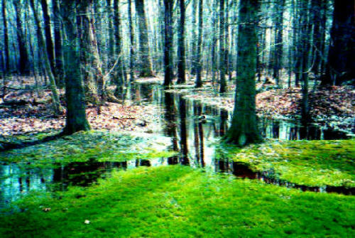
Figure 3. Standing water in the wetlands in the vicinity of the project area. (Picture from the Citizens for a Green North Tonawanda web site. Retrieved from http://www.geocities,com/rainforest/vines/3317/photosummer/s2a.jpg on October 31, 2000. The location and dates of photos have not been verified.)

Figure 4. Klydell Wetlands in the summer showing standing water. (Picture from the Citizens for a Green North Tonawanda web site. Retrieved from http://www.geocities,com/rainforest/vines/3317/photosummer/photosummer2.jpg on October 31, 2000. The location and dates of photos have not been verified.)
Apparent Impacts of Hydrologic Alteration
A ditch that is approximately 3 meters wide and 0.5 meter deep traverses the eastern and northeastern perimeter of the property. While, in theory, this ditch could be draining water from the wetland site, in actuality it does not appear as though this ditch has a significant effect on the wetland hydrology of the site. There are two aspects which indicate this minimal influence. First, the ditch has a prominent berm on the west side where the spoil material from the ditch construction was placed that would retard the movement of water from the site into the ditch. Secondly, the growth of mature trees on the berm of the ditch indicates that the ditch has been in place for an extended period of time. Many of the saplings and understory vegetation in the project area are younger than the ditch, and the vegetation is still dominantly hydrophytic, showing that the area is still wet enough after ditch construction to support wetland vegetation. Thus, the ditch appears to be having a minimal effect on the wetland hydrology of the site.
Summary
Hydrologic measurements and observations on the Kinkead Avenue and Meadow Drive site have not been made in the mid-April to late May time frame, which is necessary to firmly establish whether wetland hydrology is present on the site. However, a variety of indirect indicators, including the presence of hydric soils, the presence of hydrophytic vegetation, the lack of understory vegetation in low areas, and undated photographs taken in the vicinity showing standing water suggest that wetland hydrology is likely to be present in an area larger than that defined by the consulting firm who submitted a wetland delineation for the site.
If more definitive information regarding the wetland hydrology of this site is needed, more site-specific investigations are required. This could be done in a couple of ways. Frequent observations of the extent and duration of floodwater and/or saturation due to a high water table could be made by field personnel. Secondarily, water-level recorders and shallow wells could be installed. In either case, it would be critical to determine the best time of the year for observations to be made, and to determine whether or not the year in which the observations took place is a normal or average rainfall year.
Dear Mr. McDanell:
The following is with respect to the Klydel Wetlands, Meadow and Kinkead Streets, North Tonawanda, New York. At your request and accompanied by yourself, Harold Kepner, Mike Montone, and Mary Crosson from the Army Corps of Engineers, Buffalo Office I examined several places within the Klydell Wetlands to confirm the status of the soils, visavis hydric or non-hydric.
Stop 1. This stop was in an area designated as meeting the federal definition of a wetland.. It was in my opinion representative of this area. Location: N. Latitude, 43 degrees, 03', 11.3'', W. Longitude, 78 degrees, 52', 29.4''. In my opinion this soil is natural and is not fill.
A horizon, 0 to 9 inches, 10YR 2/1, 1 percent 10YR4/4 redoximorphic accumulations, silt loam.
Bg horizon, 9 to 17 inches, 10YR 5/1 and 10YR 5/2, 45 percent 10YR 5/6 redoximorphic accumulations, silt loam.
This is a hydric soil: [photo not included here as it does not reproduce well]. The dominantly two chroma or less soil colors immediately below the A horizon at 9 inches are convincing evidence of that. In support of that conclusion are the very dark color of the A horizon and the redoximorphic accumulations in the A horizon. Tree trunks in the vicinity were buttressed and there were blackened leaves. The vegetation was largely facultative as described by the Corps of Engineers biologists.
Stop 2. This stop was in an area designated as not meeting the federal definition of a wetland but meeting the state definition for a wetland. It was in my opinion representative of this area. Location: N. Latitude, 43 degrees, 03', 12.8'', W. Longitude, 78 degrees, 52', 28.6''. In my opinion this soil is natural and is not fill.
A horizon, 0 to 8 inches, 10YR 2/1, silt loam
Bg horizon, 9 to 13 inches, 10YR 5/1 B material, with 25 percent 10YR 5/6 redoximorphic accumulations, 20 percent 10YR 6/2 E material, silt loam.
This is a hydric soil [photo not reproduced here] based on the dominance of chroma 2 and less soil colors below the A horizon. In support of this conclusion is the very dark color of the A horizon. In addition there were many buttressed tree trunks and blackened leaves supporting a conclusion of wetland hydrology. The vegetation was dominantly facultative as described by the Corps of Engineers Biologists.
Stop 3. This stop was in an area designated as not meeting the federal definition of a wetland but meeting the state definition for a wetland. It was in my opinion representative of this area. Location: This was a satellite stop, not far (less than 100 meters from Stop 2. 10YR 2/1 A horizon, 9 inches thick. Bg horizon has a dominance of 2 or less chroma and is a fine sandy loam. In my opinion this soil is natural and is not fill. This soil was hydric in my opinion. The soil hydrology was well supported by indicators of wetland hydrology including blackened leaves and buttressed tree trunks. AS described by the Biologists present the vegetation was almost exclusively facultative
Stop 4. This stop was in an area designated as not meeting the federal definition of a wetland but meeting the state definition for a wetland. It was in my opinion representative of this area. Location: North Latitude, 43 degrees, 03', 11.5'', W. Longitude, 78 degrees, 52', 26.4". In my opinion this soil is natural and is not fill.
A horizon, 0 to 7 inches, 10YR 2/1, silt loam/loam
Bg horizon, 7 to 14 inches, 10YR 5/1 and 10YR 5/2, 5 percent 7.5YR 4/4 and 7.5YR 4/6 redoximorphic accumulations, fine sandy loam.
This is a hydric soil: [photo not reproduced here] The dominantly two chroma or less soil colors immediately below the A horizon at 9 inches are convincing evidence of that. In support of that conclusion are the very dark color of the A horizon and the redoximorphic accumulations in the A horizon. Tree trunks in the vicinity were buttressed and there were blackened leaves. The vegetation was largely facultative as described by the Corps of Engineers biologists.
This area that we examined was mapped Canandaigua in the original soil survey. Canandaigua is poorly and very poorly drained in Niagara County and is hydric. The observations detailed above confirm that with respect to the soil characteristic of wetness the area was well mapped. In my opinion the four places that were looked at represented fairly the area at large. The soil in these four places was hydric according to the 1987 Corps Manual. In my opinion fill material on top of the soil that would have effectively buried the hydrology represented a small proportion of the overall area. It was spotty and not uniform across the landscape. In the four places where observations were recorded, as well as along the route of travel, in between the sites, signs of wetland hydrology in the form of blackened leaves and buttressed tree trunks were commonplace.
Respectfully submitted,
Steven C. Carlisle
Soil Scientist
Back to Citizens for a Green North Tonawanda MAIN PAGE. Thanks to the over 800 individuals and organizations who wrote to the Army Corps in support of the preservation of this unique wetland! You can view the permit application and compare what the developer claimed as possible wetland impacts to the studies (above) that were conducted in Fall 2000 by federal experts.